Chapter 2
An Outline of Urban Structure
Whether we take into consideration social, political, economic, or artistic points of view, we must recognize the essential role that cities play in the modern world and the influence they may have on the destiny of the people who have begun to evolve, on their environment, their organization, their health, their aesthetics.
Order and security are at play; social peace, prosperity of the nation, its artistic formation, [and] the attraction it may exert on foreigners can be compromised or assured by violation of or respect for principles of urbanism.
M. E. De Vivier de Streel, Introduction to J. Royer, L'Urbanisme aux colonies et dans les pays tropicaux
The dilemmas the French confronted in their interventions to the old town of al-Jaza'ir were paralleled and, furthermore, complicated by the considerable growth of the city following the occupation. French administrators placed great importance on urban planning as an instrument of colonization that would help establish their power and facilitate their control of the dominated society. The need for systematic urban design was acknowledged and voiced immediately following the conquest, but its translation into practice did not proceed smoothly. Several factors hindered the implementation of grand plans—among them the ambiguity of the role assigned to Algiers in the early decades of French rule; the topography of the site, complicated by steep hills separated by valleys behind a flat band along the water; and, stem-
ming from site conditions, the linear "organic" growth of the city toward the south, following the coastline. Political struggles within the urban administration and economic problems played obstructing roles as well. While these issues dominated the entire duration of French rule, the planning of Algiers displays three distinct periods. The first period covers the century between 1830 and 1930 and shows fragmented reactions to ad hoc growth. The second period extends from 1930 to the end of World War II and is distinguished by sweeping attempts to bring order to the entire city through master plans. The third period, characterized by its concentration on the regional scale, leads to the end of French rule.
From the first decades of French occupation, the organic expansion of the lower city was linear; it followed the coastline and eventually resulted in a continuously built fabric in the flat zone at the water's edge, meanwhile pushing the center of the city away from old Algiers. The hills were dotted with dispersed settlements separated from the rest by topographic conditions. Establishing a connection between the upper and lower sections of the town constituted the main issue, and plans were devised to construct a wide road that swept along the heights and many cross-streets that climbed up the slopes to provide fast access to upper neighborhoods. Starting in 1930, master plans attacked the same problems, which continued to escalate with the growth of Algiers. The master plans, like the regional plans that came later, prioritized zoning and a road network that would unify the city. With the intensification of the housing shortage in the 1950s, however, planning began to focus on the design of large housing projects, the grands ensembles.[1]
Taming the Organic Growth
When the French invaded Algiers, they settled in the old city. Uncertain about their future in Algeria, they kept urban intervention to a minimum during the first years of occupation. As seen in the previous chapter, the main operations—the opening of the Place du Gouvernement and the widening of the main arteries, Rue Bab el-Oued and Rue Bab Azzoun—depended solely on militaristic and practical necessities.
Even in the 1840s, when the French became convinced that they would stay in Algeria for good, no clear role was envisioned for Algiers.
On the one hand, plans for its future did not extend beyond military functions, as articulated by the governor general of Algeria in 1844: "Algiers must rather be a place of war, which forms the citadel of Algeria, than a town of commerce."[2] Accordingly, an early planning decision called to replace the Ottoman fortifications with new fortifications "à la Vauban."[3] Built between 1841 and 1848, the new fortifications tripled the intra-muros, while enhancing the emphasis put on defense. On the other hand, a second camp approached city building with a broader vision. Arguing that French domination in Algiers would be permanent, a group of technocrats advocated converting Algiers from a battlefield (champ de bataille ) to a workplace (champ de travail ), where a large European population would either mix with local Arabs or live next to them in peace and friendship. To enable economic development, construction of harbor facilities and commercial buildings had to be given priority.[4]
Meanwhile, the growing population of the city had already pushed the city limits toward the south, creating a major settlement in Mustafa. As early as 1839, official reports pointed to the high densities in the old town, especially to the overcrowding of the Marine Quarter and the lower casbah, where most of the fifteen thousand Europeans lived. By this time, the population of Algiers was around forty-eight thousand.[5]
Attempts at a plan that would control the urban growth and introduce a "rational" street system go back to the early 1840s, but the first project to be approved by the ministry of war dates from 1846. The project replaced the Ottoman fortifications by large boulevards that encircled the casbah. The Boulevard Vallée to the north of the casbah and the Rue Rovigo to the south, which climbed the hills with its dramatic curves, provided communication with the interior of the country (Fig. 28). Rue du Rampart (later Boulevard de l'Impératrice, Boulevard de la République, and now Boulevard Che Guevara), completed in the 1860s, defined the border between the edge of the city and its harbor.[6]
Taking into consideration the organic extension of the city southward, a second project from 1846 (Plan Guiauchain) moved the center from the Place du Gouvernement to the site of the demolished Bab Azzoun gate. The Bab Azzoun Quarter, sheltering both residential and commercial functions, had a "double physiognomy": corresponding to its topography, the lower section displayed a rectilinear arrangement of streets, with the Rue d'Isly crossing it transversely and opening up to the Place d'Isly (later named Place Bugeaud) at its center, while the upper section was cut through by curving arteries. The short streets

Figure 28.
Plan of Algiers, c. 1900. (1) Rue d'Isly, (2) Rue Rovigo, (3) Boulevard Vallée,
(4) Rue du Rampart, (5) Place de la République.
linking the Rue d'Isly to the heights were, if straight, painfully stepped. One among them, Rue Joinville, with its 150 steps, was considered by Lespès to be "a curiosity . . . a challenge thrown at nature and also a picturesque misinterpretation of urbanism."[7]
While the area around Bab Azzoun developed as a European quarter, not much happened in Bab el-Oued, except for the establishment of a few minor industries and a couple of mills. A planned working-class neighborhood, the Cité Bugeaud, was designed for this quarter in the late 1840s on the initiative of a German architect, M. Lichtenstein; it offered refuge to victims of the Janina fire, which had devastated the area surrounding the Janina Palace as well as the palace itself (Fig. 29).[8]
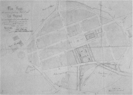
Figure 29.
Plan of Cité Bugeaud, Bab el-Oued Quarter, c. 1845.
Several projects in the 1850s called for the extension of Algiers outside its fortifications toward the south. Chassériau's "Napoléonville" from 1858 proposed to sever the European settlement completely from the Muslim town and to settle sixty thousand Europeans in two-story houses filling an orthogonal grid in Mustafa (Fig. 30). The houses were grouped around green spaces, and densities did not exceed 282 people per hectare. Given the realities of Algiers, Chassériau's project was considered idealistic and "too beautiful to become real." Two similar projects, the Vigourous-Caillat plan and the MacCarthy-Génévay plan, reiterated the same ideas the same year. None of these proposals stirred an interest among municipal authorities, whose main concern focused on the private interests of landowners in intro-muros . In addition, Mustafa obtained its autonomy as an urban unit in 1871 and pursued its own ad hoc development.[9]
On the road that led from Bab Azzoun to Mustafa, another quarter, that of Agha, had developed organically since the 1840s along Rue de Constantine, which led to the town of Constantine. Agha attracted some commercial enterprises, as well as a considerable number of caba-

Figure 30.
Charles-Fréderick Chassériau, plau for Napoléonville, 1858.
rest that capitalized on the proximity of the army camp and the Champ de Manoeuvres, the parade ground. According to Fromentin in 1852, the Agha Quarter was "an interminable line of restaurants and cafés [buvettes ]," forming a striking contrast to the sombre Muslim town.[10]
Perhaps the most significant urbanistic event of the 1860s was the completion of the Boulevard de l'Impératrice, which extended from one end of the city to the other within the French fortifications, unifying the waterfront (see Fig. 19). This boulevard enhanced the planning of adjacent areas, among them the Square Bresson (later Place de la République, then Square Aristide Briand; now Square Said), which definitively welded the old town to the new one. Defined on one side by the Grand Theater, one of the first French monuments in town, Square Bresson opened to the waterfront on the other. It was lushly planted and decorated with statues; the music stand in the center was topped by a dome from a demolished sixteenth-century building. The Boulevard du Centaure (later Boulevard Gambetta, now Ourida Meddad), leading from Square Bresson to the hills behind and following the line of the former Ottoman fortifications, was an "immense stairway" with about two hundred steps and periodic platforms (Figs. 31 and 32). On the up-

Figure 31.
Plan showing the juncture of the casbah and the French city.
per parts of the Boulevard du Centaure the first casino in Algiers was built in the 1880s in an effort to accommodate the British tourists and to turn the city into an hivernage (winter resort).[11]
The Rue de la Liberté, parallel to the Boulevard de l'Impératrice, was also laid out during the 1860s, simultaneously with a network of or-

Figure 32.
View of Square Bresson, with the Grand Theater in the foreground, c. 1900.
thogonal streets, creating a new neighborhood (Fig. 33). Due to the 10-meter width of its streets and the uniformity of the buildings lining them, this longitudinal quarter was considered the "best designed," the "best ventilated," and the "best built." The two government buildings back to back to each other in the center, the Central Post Office facing the Boulevard de l'Impératrice and the Palace of Justice the Rue de la Liberté, added further prestige to this strip.[12]
Mustafa's autonomy lasted until its reannexation in 1904. During the 1870s it grew considerably, in part due to employment resulting from the construction of the Civil Hospital. Random development of the neighborhood was difficult to correct, however, and the attempt of a master plan to regularize the quarter failed, because it did not take into consideration topographic characteristics. The Rue de Télemy (now Salah Bouakouir) remained a unique intervention. Originally conceived as a 10-mater-wide corniche that would span the heights of the city and offer spectacular views of the bay, its width was reduced to 7 meters for reasons of economy.[13]
The lifting of the forty years of military regime in favor of civilian rule in 1871 had important consequences for the city of Algiers. The military terrains and easements occupied a huge area encircling the city; within the fortifications, this amounted to 160 hectares, as opposed to the 86 hectares left for public use. The city walls had also become obsolete, acting only as artificial barriers between Algiers proper and its

Figure 33.
Plan of Algiers, c. 1900. (I) Mustafa, (2) Jardin d'Essai, (3) Boulevard Laferrière, (4) Rue de Télemy, (5)
Rue de Constantine, (6) Rue de la Liberté, (7) Boulevard de l'Impératrice, (8) Bab el-Oued, (9) Boulevard
Guillemin, (10) Square Nelson, (11) Rue Randon.
suburbs. After negotiations that lasted over a decade, the demolition of the ramparts began in 1894. The turbulent negotiations themselves constituted one of the two main urbanistic activities from the 1880s to the beginning of the demolitions (with the exception of one new street—the extension of the Rue Randon).[14]
The other major event in the planning of the history of Algiers at the time was the Projet de transformation, d'extension et d'embellissement de la ville d'Alger , prepared by Eugène de Redon in 1884. Taking into consideration the inevitable growth of the city southward, Redon proposed to connect Algiers and Mustafa by placing a maritime quarter in the Bab Azzoun area. Sheltering new sea and land transportation installations, a train station, and a large commercial area, and facing a new basin, this quarter would replace the Bab Azzoun fort. Redon extended the Boulevard de la République for 900 meters toward Agha and foresaw the development of the zone gained by the demolition of the fortifications, around a main boulevard that connected the waterfront to the heights—later realized as the Boulevard Laferrière.[15]
To compensate for the real estate lost by the military in the redesign of the Marine Quarter, Redon introduced a military quarter in the north, near Bab el-Oued. This quarter was organized by means of three arteries parallel to a 630-meter-long and 25-meter-wide boulevard on the waterfront, the Avenue Bab el-Oued; other streets perpendicular to those would ensure excellent ventilation. Furthermore, Redon proposed to renovate the Bab el-Oued Quarter entirely in an effort to balance development in the north of the city with the expansion of the southern suburbs. The corniche boulevard would be continued, and six principal roads parallel to it would be intersected by perpendicular streets, forming, once again, a well-connected and spacious network.[16]
As Lespès argued, even though actual city building was minimal between 1880 and 1896, an important development had taken place: the city administrators had formed a clear opinion on how to deal with the problems of Algiers. They understood that the future of the city was based on its merging with suburbs in the north and south; the Mustafa and Bab el-Oued quarters had to be incorporated into Algiers proper. In addition, Algiers was now considered the capital of French Africa and potentially a great city of commerce, not a mere military and naval outpost. In 1896, its population was over 120,000 people; of these, about 92,000 lived in Algiers proper and 35,000 in Mustafa.[17]
The heyday of building activity in Algiers occurred between 1896 and 1914. On the land bought from the army by the city administration, the
municipality built sixty-six roads. The impressive developments to the south underscored the inevitable shift of the center: the Rue d'Isly, until then dotted with makeshift shops and insignificant buildings, became lined with large and "beautiful" structures; another well-built neighborhood emerged in the Isly Quarter and around the newly extended Bugeaud ramp; the terrains between Rue de Constantine and Boulevard Carnot also were developed. To the north, the Esplanade Quarter was built around a central square, the Square Nelson (now Square d'Istanbul); the heights of Bab el-Oued, below the el-Kattar cemetery, acquired twenty streets lined with impressive buildings. In addition, two new boulevards replaced the former fortifications: Boulevard Laferrière (now Mohamed Khemisti) to the south and Boulevard Guillemin (now Abderahmane Taleb) to the north, both alternating ramps with leveled platforms to soften the topography. The lushly planted central strips of these avenues acted as longitudinal mini-parks, compensation to some degree for the lack of open space in the city. Another important urbanistic gesture was the decision to create a large public park in the Jardin d'Essai in 1912.[18]
This intensive building activity could not always be controlled and regulated. While certain urban fragments benefited from careful plans, others were not so lucky. For example, the lower and upper sections of Mustafa, as well as Belcourt and Hamma, grew fast but without any plan (Fig. 34).[19] Inevitably, the more prestigious quarters became the focus of attention and benefited from urban design in the "grand manner," albeit in a piecemeal fashion. The location of a number of new monuments, such as the new Prefecture on the Boulevard de la République and the Central Post Office on Boulevard Laferrière—both built in 1906 in neo-Islamic styles—emphasized further the primacy of certain quarters (Fig. 35).
The ad hoc growth pattern set by Mustafa, Belcourt, and Hamma became the norm until 1930. Not only did the built fabric of the city begin to climb up farther onto the hills, appropriating any available land, but also the former pattern of "Moorish-style" villas in gardens on the heights gave way to much denser settlement patterns; the original owners of such villas now preferred to live in the fashionable apartments downtown. Densities in the older quarters of the city rose, too, due to the increasing building heights and new construction on every leftover open space. Yet it was the linear expanse that most overwhelmed people concerned with the future of Algiers. In 1930, Algiers extended for 8 kilometers along the shore from St. -Eugène to Hussein-Dey, in

Figure 34.
Schematic plan showing the area occupied by Algiers in 1930. The dark lines on the left and the right indicate
the area covered in the 1948 regional plan.

Figure 35.
View of the Prefecture on Boulevard de la République. The arcades of the
harbor are in the foreground.
what was repeatedly characterized at the time as "chaotic growth." In between the built areas lay land that belonged either to the military or to the public (such as hospitals).[20]
Unlike other French colonial cities, Algiers was not strictly segregated into European and indigenous quarters. The exception was the casbah with its almost entirely Algerian population; other areas showed varying degrees of population mixture. In 1926, 212,000 people lived in Algiers (including Mustafa). The intra-muros had 112,000 residents: about 45,000 were Algerians, mostly concentrated in the casbah, and 67,000 were Europeans residing in the quarters to the south of the casbah and in the less affluent Marine Quarter. Mustafa's population consisted of 64,000 Europeans and 10,000 Muslims. Bab el-Oued had only 800 Muslims, out of a total of 26,000 residents.[21]
The Age of Master Plans
The first French law on "urbanism" dates from 14 March 1919. Considered "the charter of modern urbanism," this law called for a master plan for every town having more than ten thousand people in
order to regulate growth and enable "beautification" (embellissement ). The plan would thus determine the street network once and for all, specifying the layout and width of all the streets (including the design of new ones and modification of old ones) and the location and character of all open spaces—public parks, gardens, and squares—as well as of monuments and public service buildings.[22] Undoubtedly, the technological, social, and aesthetic lessons learned from city planning practices previously undertaken in French colonies played a primary role in devising official policies for urban development in both metropolitan France and outre-mer . Similar regulations for orderly urban development were in place in other parts of Europe at the time, and while the French were influenced by these trends, they relied more heavily on their own ideas about urban planning. To reiterate a familiar argument, the colonies were true laboratories of modern planning.
Yet although Algiers was the foremost among France's colonial cities, it had never been a real laboratory. Its development had followed a haphazard pattern; decisions were made on the spot, in accordance with the ambiguous and unsettled policies of the early colonial period. In fact, the mistakes made in Algiers were in part responsible for the more orderly planning in other colonies. In turn, the urbanistic lessons learned from the later colonies and empowered by the growing confidence in modernism were reformulated in the 1930s to be applied to France's oldest colonial city. The curious story of Algiers's "rational" planning after 1930 is indicative of the waves of changes in colonial policies, as well as the city's unusual status vis-à-vis France.
Algiers's master plan, a pioneering scheme that put the 1919 law into practice, was approved in 1931 and revised twice, in 1933 and 1934. Initiated by the newly created Service Municipale de l'Urbanisme, it was drafted by Henri Prost, René Danger, and Maurice Rotival. Prost was considered an especially fortunate choice to correct the former errors and offer "new and sound" rules because of his extensive experience in Morocco and the "happy and rational" results he had obtained there. Nevertheless, given the "disordered and incoherent character" of Algiers, expectations were conservative. Lespès, for example, could foresee only "partial improvements" succeeding in the old built fabric; he displayed more optimism for new quarters planned for vacant zones.[23]
Following the new trend in urban planning, the Prost plan (as the master plan came to be known) called for strict zoning, qualified as "methodical discrimination" but based on current needs and tendencies (Fig. 36). The city was divided into four zones, A, B, C, and D. The commercial area, zone A, covered the lower part of Bab el-Oued, the
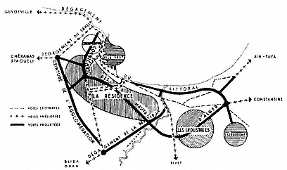
Figure 36.
The Prost plan, 1930–37. Zone A follows the coastline; zone B covers the
area marked as "la résidence"; zone C is on the heights of "la résidence"; zone
D comprises the areas marked as "agglomération" and "industries."
Esplanade Quarter, the old town, Agha, and the middle and inner parts of Mustafa all the way to the Jardin d'Essai; it would be filled with apartment buildings, offices, shops, cafés, restaurants, small workshops, and garages; the roads would be a minimum of 12 meters wide. Zone B was residential and consisted of small, single-family houses (whose maximum height could not exceed 15.2 meters) covering a large and longitudinal area from Bab el-Oued to Mustafa; the streets would again be a minimum of 12 meters wide. Zone C, located on the heights of Mustafa, had "country cottages" in gardens, in an effort to preserve the natural beauty of the particular site. The industrial region, zone D, was on the southern border of Bab el-Oued, as well as to the south, past the Jardin d'Essai. But the real industrial suburb of Algiers was Hussein-Dey. The main roads of the industrial zone were envisioned as 18 meters wide, whereas the secondary ones could be 12 meters. In accordance with the tendencies already in place, industrial working classes were to be housed close to their workplaces, whereas the upper regions of the "amphitheater," which enjoyed a better climate and were in demand by upper classes, would be reserved for villas in gardens and parks.[24]
Within these general outlines, the plan had specific provisions. For example, the Marine Quarter would be demolished completely and re-built; new quarters were to be designed in the area gained by the appro-
priation of the Champs de Manoeuvres, in Mustafa, and on the waterfront near Bab el-Oued; in the densely built quarters, many existing streets would be enlarged and new ones cut through; and the greenbelt defining the heights of Algiers would be preserved, because it was essential for the health, charm, and beauty of the city. The construction of four new roads would improve the communication system of Algiers radically. The corniche along the waterfront would continue the Boulevard de l'Impératrice toward Hussein-Dey and extend for another 13 kilometers; a "ring road" on the zone cleared from the fortifications would add picturesque and aesthetic values to the city; the middle region (the residential section) would be crossed with the help of tunnels which also linked the waterfront to the heights; and, finally, another belt road would envelop the entire agglomeration.[25] One of the first segments of the Prost plan to be completed was the ring road. The Boulevard Laferrière (on the site of the demolished French fortifications), considered to be a great urbanistic achievement, was extended to a vast esplanade of about 3,000 square meters—the "real forum of new Algiers."[26] No longer a traffic artery, it was turned into a lushly planted park with spectacular views. Prost and his colleagues proposed a tunnel under Boulevard Laferrière that would start at the docks (at the Maritime Terminal) and connect to the ring road at the heights (Fig. 37). An exit at Rue d'Isly would enable access to a central location in "downtown" Algiers, close to the Central Post Office, and another exit would lead to the new development of Tagarins farther up the hill.
Rotival justified this ambitious plan by defining the new role that Algiers would play as the capital of an African empire, as a business, commercial, and industrial center, and as a residential town. He likened the task ahead to the rebuilding of Paris under Napoleon III. Confronting the criticism directed at the plan he and his colleagues had drafted, he argued that if Baron Haussmann had not been supported by Napoleon III against his own critics, Paris would now be a "poorly designed village without a future."[27]
The main challenge to the Prost plan came from Le Corbusier, in the form of several (unimplemented) projects for the city between 1932 and 1942.[28] Le Corbusier was not officially commissioned to develop a master plan; his involvement with Algiers had started through an invitation from the Friends of Algiers in 1931 (to deliver a series of lectures on urbanism within the context of the centennial celebrations) and was pursued on his own initiative. While his designs are commonly seen as a critique of French urbanism, in essence they did not diverge radically

Figure 37.
Proposal for a tunnel under Boulevard Laferrière by Prost, Danger,
and Rotival, 1937. (1) Entrance to the tunnel from the maritime
station, (2) access to Rue d'Isly, (3) exit from the tunnel at Tagarins,
(4) rectified rail connection to Télemy, (5) terrace, (6) corniche of
Fort l'Empereur, (7) Ta-garins park, (8) exit from the tunnel at
Frais Vallon.
from the proposals of Prost and his colleagues; the differences were formal, not conceptual, and exaggerated mainly by Le Corbusier's own vast and vigorous propaganda. Le Corbusier began his critique of contemporary urbanism by arguing that French interventions during the last five decades had caused the destruction of Algiers. He wrote: "The last fifty years of European colonization abolished without any regrets the natural richness and petrified the new city into a desert with its crowded houses leaning onto noisy streets." Like the cities of Europe and America, Algiers had sickened, for it had been shorn of its poetry.[29]
Curiously enough, Le Corbusier respected the original achievements of the French colonial oeuvre and credited the first decades of French rule with good urbanism. He had already clarified his standpoint in La Ville radieuse , where, including a plan that indicated the first interventions (the Place du Gouvernement and the Bab Azzoun and Bab el-Oued streets) he expressed his admiration for early colonial urbanism: "The military rulers of the conquest knew how to make beautiful city plans. They knew how to urbanize."[30]
While Le Corbusier's diplomatic plot to obtain the commission by associating the current administration with the glorified conquerors is quite transparent in this statement made on the centennial of the occupation, his repetition of the same theme in various contexts reflects his firm support of French colonial policies. For example, celebrating the mission civilisatrice in Morocco, he praised the instruction, loyalty, and justice brought by the French, as well as the network of roads and cities they had built—all "signs of civilization." These achievements, he argued, had created an atmosphere of admiration, enthusiasm, and respect among the Arabs: "The Arab discovered his educator, his instructor. He did not bat an eyelid of doubt. With two hands outstretched, leaving all his hopeless deceit behind, he loved, admired, understood the new times and respected France with all his conviction. Architecture and urbanism can be the great educator."[31]
In accordance with the colonial mission, Le Corbusier's Algiers—the "French capital of Africa," the "head of French Africa," and the "phoenix of France . . . reborn out of the ashes of the mother country"—would reinforce French rule not only in Algeria, but throughout the entire continent.[32] The architect expressed this view passionately in his writings, but also in several drawings where an axis originating in the north continues into Africa, connecting France, from Le Havre via Paris to Marseilles and across the Mediterranean, to Algiers and farther in (Fig. 38). Sketches of skyscrapers indicate the cities along the
Figure 38.
Le Corbusier, sketch showing the unification of
the French colonial empire by urbansim.
axis, proposing to unify the greater France through a new architecture and urbanism. With such drawings, Le Corbusier was reiterating the notion of a geographical axis between France and Algiers, a repeated theme in colonial discourse. For example, Cotéreau, a prominent engineer who worked for the urban administration of Algiers, argued in 1933 that the city must be renovated by means of a "sane architecture, following Aryan traditions," because of "its position on the axis of France."[33] Le Corbusier's sketches depict, furthermore, the idea of la plus grande France , which represents not only an imperial French doctrine, but also a colonial consciousness developed in 1930. Minister of Colonies Paul Reynaud summarized this new mindset at the time: "Everyone among us must feel he is a citizen of the greatest France [la plus grande France ] that expands to five parts of the world."[34]
Le Corbusier's 1932 Obus A plan (the word obus being a reference to the trajectory of an exploding shell) ignored the existing city by and large and superimposed a new system. A curvilinear viaduct along the

Figure 39.
Le Corbusier's Obus A plan, 1932.
waterfront connected Hussein-Dey to St. Eugène, emphasizing the linear development of the city and reinterpreting the corniche in the Prost plan (Fig. 39).[35] Le corbusier's desire to respond to the geography of the site and to muster views of the Mediterranean was the driving factors behind his proposal; the viaduct (which would house working classes) can be regarded as a second, and raised, corniche running parallel to the first one, the Boulevard de l'Impératrice. The Marine Quarter, entirely demolished and transformed into a cité d'affaires , reflects a conceptual similarity to zone A of the Prost plan. Yet the scale is radically different, as Le Corbusier's scheme is dominated by high-rises. The housing blocks of Fort-l'Empereur on the hills, intended for the middle and upper classes, can be seen as the equivalent to the zoning of the heights of Mustafa for upper-class residences by Prost and his colleagues. The last major element of the plan, the elevated highway that connected the housing on the hills of Fort-l'Empereur with the business center in the Marine Quarter, addressed the much-debated problem of linking the coast to the heights—a problem that Prost and his colleagues had attempted to resolve by means of underground transportation.
Obus A was formally the most spectacular of Le Corbusier's Algiers plans. In successive plans, he modified the original scheme in accordance to the responses he received. In Obus B of 1933, for example, he eliminated the viaduct and gathered all the functions of the business center in a single skyscraper. Obus C of 1934 was restricted to the Marine Quarter only and again proposed a single skyscraper. This building
became the principal focus of the proposals and took different forms: in 1938 it acquired a Y-shaped plan (Obus D), and in 1939 it was transformed into a building whose facades were defined by Le Corbusier's hallmark brise soleils (Obus E).
The 1942 project was the last and the most conventional of Le Corbusier's schemes for Algiers. Although it came closest to Obus A in its scope as a master plan, it diverged dramatically from the proposal of 1932 in terms of its formal qualities. A coastal road replaced the viaduct, approaching closer to Prost's corniche, and zoning dominated the plan, delineating separate functions that were not connected to each other. The business center was moved from the Marine Quarter to the eastern end of Boulevard Laferrière, away from the casbah and clearly serving the European community. Similarly, the civic center was transported to Agha, again shifting the center toward the European town. Recreation facilities were placed along the coastline of Bab el-Oued and in the vicinity of the Jardin d'Essai; industry was concentrated in Hussein-Dey, and the port maintained its commercial and transportational functions. Residential zones, distinguished with their Y-shaped high-rises, dominated the hills, affording good views and providing for public gardens and parks. The Marine Quarter was now reserved for "Muslim cultural institutions," with the argument that this transformation would enable the cleaning of the lower part of the casbah and bring a new vitality to the casbah-Marine ensemble.[36] The separation between the European and indigenous communities would thus be secured even more firmly than in the previous schemes.
Le Corbusier's progression from Obus A to the plan directeur reflected the architect's persistent efforts to secure the commission by conforming to established norms. As argued by Mary McLeod, the architect's involvement with the landscape became limited to details and moved away from broad gestures that had endowed Obus A with its lyrical plasticity.[37] Not surprisingly, it is the more "realistic" aspects of Le Corbusier's later plans that made an impact on the future architecture of Algiers. While the Algiers plans have become keystones in the architectural discourse on modernism, their impact on the city of Algiers itself remained minimal. The most memorable urbanistic aspects on paper—the daring proposals of Obus A—were the least influential, whereas the plan directeur surfaced in small fragments now and then in subsequent efforts to regulate the city. Le Corbusier's influence on Algiers remained on the architectural level and manifested especially in the 1950s.[38]
Expanding the Boundaries: Regional Plans and Grands Ensembles
The international economic crisis of the 1930s hit Algeria seriously, although a few years later than it had disrupted France. Affected by an economic crisis that included a plunge in exports, high inflation, unemployment, and lack of funds for building investment, the master plan drafted by Prost and his colleagues could not be implemented. World War II made matters only graver and forced the colony into a closed economy.[39] Not until 1948 was the attempt to address the city's problems and to achieve a comprehensive solution revived. In the meantime, the housing situation in Algiers had deteriorated to the degree that the 1948 plan d'urbanisme (which literally duplicated the Prost plan and survived with minor alterations until 1976) prioritized housing over other issues in a move that would dominate all subsequent planning activities in Algiers until the end of French rule. In effect, the origins of the bidonvilles that became the nightmare of planners from the 1950s onward began in the early 1930s: as noted by sociologist René Maunier, gas barrels (bidons ) were used "even to build walls" in 1932.[40]
Inflation and unemployment had hit all lower-income groups, but indigenous populations suffered the most. Attempts by colonial authorities to provide housing for all lower-income groups, and especially for Algerians, stemmed from a fear of uprisings. Private enterprise, however, favored lucrative luxury housing for the wealthiest sector of the European community and refrained from investing in the peripheries for more modest populations. It had become clear to all parties involved that large-scale housing operations should be relegated to the public sector.[41]
In spite of the lip service paid to the intellectual, administrative, military, judiciary, and religious centrality of Algiers and its role as the capital, the principal premise of the 1948 plan, implemented only in parts, revolved around developing residential zones on the heights. Housing would be built on the ridges and plateaus, while the actual center was reserved for tertiary activities and the valleys conserved as parks, with roads connecting the various quarters in the valley beds. In the already built-up quarters further growth would be blocked; the new residential zones would be defined by clear boundaries and divided into two categories. The "peripheral residential sectors," reserved for modest-income groups and kept to a maximum density of 124 persons per hec-
tare, would be located near industrial zones or preexisting similar residential neighborhoods (such as Ouchaya). For the "sectors with special status," however, densities were envisioned to vary between 97 and 294 persons per hectare; here residential buildings could range from one to twelve stories in a "subtle" arrangement that would conform to the site; such quarters would occupy the more favorable ridges and platforms (like Les Annassers in Kouba) that afforded good views.[42]
Development of "industrial" and "rural" zones was the other component of the plan. Industrial zones were divided into three: the "mixed" areas in Hussein-Dey along the coast to the south, which also sheltered certain nonindustrial activities; the "first- and second-class" industrial areas situated well outside the city, along the railways leading to Oran and Constantine in opposite directions from Algiers; and the "third-class" industrial zone in the Kouba quarter on the southern hills. Following the zoning principles by now accepted universally, the concentration of industry intensified with distance from the city proper. "Satellite cities" for workers were to be situated in the proximity of factories, but separated from them by means of green areas. Finally, "rural zones" were projected for the borders of the settlement—to the west, in Sahel, fields for fruits and vegetables, and to the east, in Mitija, land for grapes and cereals—in a first-time gesture to organize the site around the city as part of a regional plan.[43]
The proposed road network consisted of two coastal exits, one from the east and the other from the west, reiterating once more the importance of the waterfront connection. Two arteries, going east and west, would connect the coastal road to the rural hinterland. A corniche running parallel to the waterfront divided the settlement in two and formed the spine of the residential settlement, ultimately connecting to the industrial zone and to the airport farther to the east. This first regional plan for Algiers thus defined a huge triangular area, with the waterfront as its base, Châteauneuf as its summit, and the valleys of Oued M'Kacel (Frais Vallon) and Oued Kniss (Femme Sauvage, now Mohamed Belkacemi) defining the sides (see Fig. 34).[44] A triangular pattern echoing the original settlement persisted, but on a dramatically enlarged scale. The urban image had changed radically, too. In contrast to the compact form of old Algiers, surrounded by vegetation on three sides, against a background of steep hills, the Algiers of the mid-twentieth century was a sprawling city. It circled the entire amphitheater of the bay and extended into the hills, its built fabric broken up by random green zones. Within this immense agglomeration, the casbah stood out in its urban-
istic configuration. Clearly in opposition to French Algiers, it still dominated the urban image with its uniqueness.
By the early 1950s, restricted use of the city's open zones was no longer considered a viable solution to the housing problem. The heights of the city and other areas not built on due to their difficult topography were now seen as inevitable sites for development, if furnished with a road network that, "inscribing itself into the site," would conform to the specificities of the land. Sweeping plans could no longer respond to the new scale and complexity of Algiers; a decentralized strategy was proposed which divided the city into quarters and relegated them to individual planners who would report to a central office of urbanism that coordinated the different projects.[45] Expanding the scope, planners and administrators agreed that a regional approach had become necessary and developed the Plan Régionale d'Urbanisme. This plan took two essential measures: regional management and zoning. The principles that underlined the first measure included decreasing congestion in Algiers, conserving the greenbelt around the city by limiting land occupation, placing new housing projects on slopes, and developing a road network between new quarters and employment centers. The second measure proposed six new zones, three dedicated to housing, others to industry, green areas, and finally to rural development (at the edges of the city).[46]
Between 1948 and 1954, Muslim immigration to Algiers significantly increased the population, deteriorating housing conditions and resulting in the multiplication of bidonvilles .[47] The growth of squatter settlements intensified ethnic segregation, with "European Algiers" becoming more and more isolated from "Muslim Algiers." Europeans were concentrated in the center, along the waterfront from Bab el-Oued to Champ de Manoeuvres, extending as far as the coastal suburbs of Hussein-Dey and St.-Eugène, and in neighborhoods on the slopes that-dominated the amphitheater of Mustafa. The "Muslim" zones consisted of the casbah in the north, its extension Climat de France, the "petite casbah" near Hamma in the south, sandwiched between two larger squatter settlements, Mahieddine and Clos Salembier, and Kouba, Hussein-Dey, and Maison-Carrée farther away. The divided nature of Algiers was particularly evident in the daily life and commercial activities. The "Moorish cafés" and small shops of the casbah contrasted with the "milk bars" and haute couture boutiques of the Rue d'Isly (formerly Rue de Chartres). Although Algerian workers crowded the European quarters, there were no Europeans visible in the Muslim quarters.[48]
In response to and in accordance with the spirit of the 1948 plan, the seven years from 1954 to 1961 were marked by intensive campaigns to build large-scale housing projects, a period characterized by Jean-Jacques Deluz as l'ère française des grands ensembles .[49] Jacques Chevallier, the mayor of Algiers elected to office in 1953, "attacked the problem [of shantytowns]," which in 1953 sheltered 125,000 Muslims in the region of Algiers, up from 4,800 in 1938. In Algiers proper, the mayor stated, 120 bidonvilles had "invaded like a plague any available land," condemning 80,000 Algerians to live in "unheard of conditions," while the casbah beat "one of the world records of human density" with its 70,000 residents.[50] The first grands ensembles in Algiers, Diar el-Mahçoul and Diar es-Saada, built on terrain cleared from squatter houses, date from Chevallier's tenure.
Jacques Chevallier also established the AEDAA (Association pour l'Etude et le Développement de l'Agglomération Algéroise, known from 1955 on as "l'Agence de Plan") in 1954. Divided into three sections—technical studies, ethnographic and economic studies, and general services—this organization brought together a team of architects, urbanists, cartographers, and sociologists under the direction of Gérald Hanning, an urbanist.[51] The mayor's goal was to "represent all organisms interested in the harmonious development of the city."[52] The official philosophy of the agency was publicized as "an empirical and evolutive urbanism, concerned with operations, rather than plans." According to this approach, a good plan matured slowly and responded to the life of a city or a region; nevertheless, urbanism went beyond the realm of plans, which were not ends in themselves, but served only to limit the margin of error.[53]
Hanning's ideas on urbanism differed from those of classical urbanists, who favored rigid functional zones, and from the "macro-architecture" of Le Corbusier. Hanning argued that, within a general framework (the plan), the city should have the capacity to provide continuity even if conditions changed. To accommodate flexibility, he proposed a conceptual plan he named the trame d'Alger, the "frame" of Algiers (Fig. 40). Debating that the stereotypical acceptance of the crescent shape of the Bay of Algiers related only to the coastal zone and that it was a mistake to base master plans on this form (as had been done in the past), he maintained that the edge of Sahel ridge that gave way to a sudden faultline should be taken as the starting point to reorganize the city. The site thus presented a T-shape configuration with the stem of the T toward Maison-Carrée about 10 kilometers long and its shorter

Figure 40.
Hanning's trame d'Alger, 1958.
line extending 5 kilometers. This conceptual organization divided the site in two, in a pattern reminiscent of previous developments: the lower zone and the upper zone.[54]
Hanning proposed an orthogonal frame, based on his interpretation of the site and with a transversal axis at an angle turned 28°30' northeast. This shift, he argued, allowed for the best conditions in the orientation of buildings, as well as conforming to the topography. Even though Hanning was opposed to the zoning principles of "classic" planners, his own solution separated functions to a certain degree, affiliating his scheme with the earlier ones. For example, his lower zone, the coastal one, was reserved mainly for economic activities; here, housing and administrative and public services were limited. The slopes of the valleys, from where access to the waterfront was easy, were to be developed for mass housing, the grands ensembles . The heights of Algiers were maintained as residential, but converted from "dormitory" to "satellite" settlements and endowed with administrative, professional, commercial, and even some industrial functions. Main industries were pushed farther away. The new road network, the trame, did not conform to the existing one, deemed insufficient by Hanning, but reorganized the city on the east-west axis; it thus diverted the former focus on the waterfront to the

Figure 41.
Project for the waterfront, 1951.
heights by establishing a strong connection between the coastline and the inner quarters.[55]
Considered an absurdity, Hanning's proposal remained on paper. Mayor Chevallier's tenure was marked by other achievements, foremost among them large-scale housing projects. Furthermore, two initial sections of the grands boulevards supérieurs that would eventually form a new ring connecting the hills of the city were constructed under Chevallier.[56] Projects to regulate the waterfront and the detailed plan to reorganize the Mahieddine Quarter along a large promenade were, however, ignored by the next wave of urban administrators, technocrats of the Plan de Constantine (Fig. 41).
Even though the Plan de Constantine aimed to encompass the entire country in a well-balanced manner, cities and especially the capital reaped the greatest benefits and grew disproportionately during the last years of colonial rule. A great deal of housing was built during this last French campaign to keep Algeria, but the desperate rush was not systematically and sensitively managed. The master plans based on arbitrary concepts were strong on zoning and functional segregation—in direct opposition to the master plan developed by Hanning a few years earlier. They were devised by engineers, practical-minded graduates of the grandes écoles (mainly the Polytechnique and Ponts et Chaussées), who were newly arrived from France and who considered the architects
and urbanists previously involved in the planning of Algiers hopelessly romantic. The goals were numerically clear and should be achieved efficiently: two hundred thousand housing units had to be built, four hundred thousand employment opportunities created, two million children schooled, and so on.[57]
The novelty was the development of a new legal concept, zone à urbaniser en priorité (zone to be urbanized in priority), or simply ZUP. Such zones had to be residential with a minimum of one hundred units.[58] The two ZUPs designated for greater Algiers were the satellite towns of Les Annassers, whose development had already begun under Mayor Chevallier, and Rouiba-Reghaia to the east. Their architectural "ideal" has been mocked as approximating a "match box," their urban design principles as relentlessly orthogonal, and their construction quality as "miserable."[59]
In terms of circulation, the corniche on the heights of Algiers (begun under Chevallier) was constructed, as well as six transversal roads intersecting it. This was in accord with the general principles of the Plan de Constantine, which specified the importance of freeways and bypasses, as well as the modernization of the transportation infrastructure.[60] For a parking garage that would hold as many as six thousand cars, reviving an earlier scheme from 1951, engineer Henri Côte proposed to lengthen the boulevards on the waterfront and use the spaces under the embankments, in an attempt to centralize parking as prescribed by the Plan de Constantine.[61] Public transportation was also addressed: aside from devising new tram and trolley routes, a subway system would connect the heights of Bab el-Oued to the lower part of the casbah and follow a route parallel to the coastline and reach all the way to Hussein-Dey; it would branch off at the Central Post Office and lead to Télemy on the hills, where the university is located.[62]
The intensification of the War of Independence forced the French authorities to halt construction activity in Algiers. All investment now concentrated in the creation of an administrative satellite in Rochet Noir, 50 kilometers to the east of the city, thus relatively protected from the war. Built in several months, the new center acted as the home of the provisionary government for only a few weeks prior to the declaration of independence.[63]
Although the ambitious plans were not implemented, they had engraved a vision of the future for Algiers that was disseminated by popular media. The daily Echo d'Alger , for example, published a series of articles in 1959 titled "'Grand Algiers': How Do You Imagine [It] in Twenty or
Thirty Years?" Without exception, the respondents agreed on an image determined by the architecture and urbanism of the grands ensembles , by huge building blocks, separated from each other by means of parks and gardens. Wide freeways, ample parking, and technologically advanced public transportation systems (such as elevated cablecars) complemented the vision of the modern metropolis.[64] This image would continue to haunt the city.
The daring interventions envisioned for Algiers under the guidance of the Plan de Constantine were, according to Deluz, products of a militaristic mentality, obsessed with quantification, regimentation, discipline, and control.[65] They constituted one front of the Battle of Algiers as well as a return to the first phase of colonial interventions to the city—again characterized solely by militaristic concerns. In addition to the militaristic mentality framing the beginning and end of French planning activities in Algiers, two other themes run through the French rule. First is the dichotomy between the lower city that grew along the waterfront and the settlements on the hills that made the upper city: they displayed different functional and physical characteristics, and creating connections between them remained a persistent issue. Second is the penchant for separating the European and Algerian populations. The initial division between the upper casbah and the French quarters translated from the 1930s onward to the designation of distinct zones to house Algerians—a pattern that worked in harmony with the urban design philosophy that treated each housing development as an independent unit.