3
Historical Background
The arctic and subarctic, sparsely populated and icebound so much of the year, has a modest historical record. Other than Eskimos, Aleuts, and Athapaskans, the first persons to arrive in Alaska north of the Yukon River seldom remained long or wrote much about their experiences. Nevertheless, there are discernible outlines to the history of each of the three villages in this study which separate them from one another. I provide brief sketches.
Whereas all three villages have been influenced by environmental calamities and epidemics in their histories, Gambell has been more influenced by a harsh and less bountiful environment than either Unalakleet or Wainwright, each of whose environments provide more places to flee to and more means to survive. And whereas all three villages have been influenced by the vagaries of the worldwide market economy, the villages of Unalakleet and Wainwright have been more involved on the peripheries of the action than has the village of Gambell.
So clear differences obtain among the three villages. Unalakleet has been influenced by extremely harsh environmental factors from time to time and by catastrophic epidemics, but in addition, it has been influenced by economic factors beyond the control of local residents. Wainwright is the youngest of the three villages (arguments can be made for a pre-1848 origin, but 1848 and, for a more permanent site, 1004 are the prime dates)..Although influenced by environmental catastrophes, it has been less affected by them than either Gambell or Unalakleet. But it has been much more influenced by economic boom and bust cycles than the other two—first whaling, then coal, then trapping, now transfers of revenues from oil.
The differences among the histories of the three-environ-
ment being most important in Gambell and economy most important in Wainwright, with Unalakleet taking a middle position-reflect their current situations. Gambell is the poorest, and Wainwright, momentarily, is the richest.
It appears evident that the multiple resources of the Unalakleet environment have lent themselves to multiple adaptations as exigencies have demanded (see Appendix c). The more limited and specific resources of the Wainwright and Gambell environments have also limited the range of adaptations possible as exigencies occur. But whereas Wainwright residents could flee if they could not subsist near the Kuuk Lagoon, flight has been much more limited for the residents of St. Lawrence Island. In general, over the course of island history, its residents have chosen to stay regardless of the vicissitudes they encounter. Wainwright residents have been compelled to stay in part because they have been engaged on the edges of the market economy for the 140 years of the village's existence.
A common response to famine or to other severe conditions in all three villages has been to share resources and labor. So the three are not dramatically different from other Eskimo and Aleut villages in this respect. Hunters lost on the sea or on land are sought by search parties. The elderly and hungry are fed. Disabled boats are assisted by passersby, even if they are in direct competition, say, in a commercial fishing market with those whose boat is disabled. Sharing is so basic to native life in all three villages that it overrides competition and personal gain if those gains would be registered while someone else suffers and the person who stands to gain must do so by not giving assistance to the person in need. The practice and the ideology of sharing, regardless of specific environmental catastrophes or epidemics that may affect one village but not another, is represented throughout all of the villages. Specific differences over the past century, environment held constant, are attributable to economic and political factors.
Of central importance to the course of history in the three villages is the role played by naturally occurring resources in the lives of villagers. They provide sustenance, define areas of interest and use, are crucial in providing goods to share and by-products for gifting and sale, and provide the focus for na-
tive ideologies and sentiments about place and space. The environment is challenging but can be understood and accommodated by natives. Threats to the environments in which they live are threats to natives which they are well aware of.
Gambell and St. Lawrence Island
St. Lawrence Island has never been an easy place to gain a livelihood. Environmental factors, storms and persistent dense fogs in particular, are key problems with which the island's residents have had to cope. Hunting parties are regularly lost at sea, as was the case in early 1989 when a walrus crew was lost in the fog for three weeks. The other walrus hunters in Gambell and its sister community of Savoonga formed teams to search for the lost hunters. The federal government provided gasoline for the searchers, who eventually located the lost men, but in the meantime, walrus hunting and walrus harvesting declined. As a consequence, the native residents on the island had to cope with a meager food supply and a meager supply of walrus ivory— e staple food and the single most important commodity available to St. Lawrence Island natives.
Great storms, and the famines they sometimes cause, have taken their tolls on St. Lawrence Island over the past centuries. This is not to say that Wainwright and Unalakleet have been free from environmental rigors; they have not. But the consequences of severe weather conditions affecting St. Lawrence Island which lasted for about one year mark a very important event in Gambell's history, and the international influenza epidemic about forty years later coincides with another major event in the island's history. Regardless of environmental challenges, the native population wants to be there and almost no place else, and they have been able to do so almost surely because of the assistance that is provided to those in need by kinspersons and friends.
The ancestors of today's residents of Gambell arrived on St. Lawrence Island from Siberia, it is presumed, probably 2,300 years ago (Burgess 1974: 20, 59). At earliest European contact, the Eskimos of St. Lawrence Island were geographically, culturally, and linguistically closer to their Siberian congeners with
whom they intermarried and visited than they were to Eskimos on mainland Alaska. Modem residents of Gambell speak Central Siberian Yupik one of four mutually unintelligible Yupik languages. Central Yupik and Pacific Yupik are spoken on the Alaskan mainland (as is Inupiaq, another mutually unintelligible Eskimo language). Central Siberian Yupik is spoken on St. Lawrence Island and in Siberia (where Siberian Yupik and Central Siberian Yupik are spoken).
Russians first mentioned observing the islanders in the mid-seventeenth century, and by the early eighteenth century, Russian and Danish maps of the Bering Sea included St. Lawrence Island (Hughes 1960: 7). At the onset of commercial whaling in the Arctic Ocean in the early 1800s, Russian maps noted the locations of thirteen settlements scattered about the island's shores and estimated 1,500 inhabitants (other estimates have placed the number at 2,500) (Burgess 1974: 23, 55; Ackerman 1976: 36). St. Lawrence Island villagers traded baleen, oil, hides, and ivory for food, clothing, and alcohol with the whalers. By the 1860s, they were hiring onto whaling vessels as crewmen.
The first major event in recent St. Lawrence Island history occurred during 1878-79 when famine on the island caused many deaths, perhaps two-thirds of the population including three complete villages, and considerable misery (see Burgess 1974: 56, 64-69). Islanders continue to view it as the most significant event in the island's history. Although the cause of the famine is not fully understood, it is likely that exceedingly harsh weather depleted native food supplies, while making replacement very difficult. Some men appear to have been away from the village working on whaling vessels during the ice-free period when they normally would be filling the family larders with the bag from hunting and fishing. Participating in the labor market, then, complicated the situation.
A federal investigation in 1881 reported that all but a handful of the survivors had convened at Sivuqaq (Gambell) and appeared to have recovered from the physical effects of the famine, without any significant aid from the U.S. government (Burgess 1974: 32, 64-65; Ackerman 1976: 39). At about the turn of the century, the few island residents who had re-
mained in Powooiliak after the famine also relocated to Sivuqaq (Burgess 1974: 31).
A Presbyterian mission and school were built by Sheldon Jackson in 1891. Jackson was both a Presbyterian missionary and the general agent in the territory of Alaska for the (federal) Bureau of Education. The school was not used until the arrival of the missionary, V. C. Gambell, in 1894. Gambell provided instruction in English to these Central Siberian Yupik speakers.
After Gambell's death, Sheldon Jackson (who wore many Presbyterian and federal hats), under the auspices of and funds from the BIA, introduced reindeer to St. Lawrence Island and also at Wainwright, Unalakleet, and many other villages throughout Alaska. The island was declared a reindeer station by Executive Order in 1903, providing reservation status to the island. Gambell's natives were given beneficial ownership (trust status, a form of impaired fide) of the island while the federal government retained fide.
The second major event in recent St. Lawrence Island history occurred about 1918 when the influenza epidemic that was devastating the world was introduced on St. Lawrence Island. At about the same time, or perhaps a little earlier, a herders' camp grew sufficiently large to splinter from Gambell and establish a new village, Savoonga. The new village became the center for reindeer herding activities on the island (Hughes 1960: 14). In addition to the fissioning of Savoonga from Gam-bell, the influenza epidemic caused many other Gambell residents to flee to unoccupied village sites around the coast to isolate themselves from the disease. All, except the reindeer herders of Savoonga, returned.
Because the Savoonga population was drawn from segments of some of Gambell's patricians, St. Lawrence Island patriclans became multilocal (a clan had segments in more than one locale). The distances between the villages and the arduousness of travel prior to the introduction of motorboats and snow-machines reduced contacts between residents of the two communities. And the focus on reindeer herding also reduced the Savoonga population's reliance on the sea.
Within a generation, Savoonga's population grew nearly as large as Gambell, and in 1939, each community chartered gov-
ernments under the provisions of the IRA. Gambell incorporated as a city in 1963, and Savoonga followed suit in 1969. These two forms of government lessened clan authority and influence on the island.
Between the time that IRA governments and the city form of governments were adopted, the residents of St. Lawrence Island got cut off from their Siberian kinspersons on the Chukotsk Peninsula with whom they shared a common language, visited, and intermarried. The U.S. and USSR governments terminated all contacts between these people soon after World War II. The Siberian Yupik people were removed to inland villages.
Some motorized equipment was used on St. Lawrence Island in the 1950s. The equipment was limited by the residents' modest incomes. Motorboats gained wider use in the 1950s and snowmachines in the 1960s, although dog traction remained paramount until 1970. Snowmachines, in particular, made it possible for clansmen in the two villages to share the bag or quarry taken in one village with clansmen in the other village.
The passage of ANCSA forced a very difficult choice on the island's residents. The islanders chose ownership of the island in fee simple, foregoing cash awards to underwrite their for-profit village corporations, which were mandated by ANCSA. Choosing to take the island did not free them from ANCSA's provision that the for-profit village corporation would have to go public in 1991. The for-profit corporations in each village were invested with joint title to the island. All enrolled members became shareholders, and still more of the powers vested in clans were lost, particularly the controls over key strategic resource areas.
The St. Lawrence Islanders have treasured their land much as they treasure their language and their common history with Siberian Eskimos. Although Central Siberian Yupik was not spoken in the schools from 1894 until 1973, virtually everyone on the island continues to speak it. Most islanders, except for a few of the elderly, are bilingual, speaking both English and Central Siberian Yupik. Villagers are proud of the fact that they have maintained their native tongue.
And although intermarriage, trading, ceremonial, and all
other contacts with their Siberian relatives and friends were terminated soon after World War II, in August 1988, the USSR's glasnost policy allowed twenty-one St. Lawrence Island residents to travel by boat to New Chaplino, about 20 miles north of Provideniia at the neck of Provideniia Bay, to spend two weeks with their relatives and friends who had been relocated there.
On Famine and Population Decline
An obvious theme in St. Lawrence Island history is the love of space and place. But the obstacles to maintaining a large population dependent on naturally occurring resources on the island are considerable and loom large.
Except for one year (1920) in which no competent census was taken, the St. Lawrence Island population steadily increased from 1,903 to the present (see fig. 2). These increases have implications for the relation between the native population and the per capita availability of naturally occurring species in the future.
If the population of St. Lawrence was 1,500 in 1878 (one estimate is 2,500), it is likely that prodigious quantities of meat were harvested to feed the people and the working dogs—much more than the amount that is harvested to feed the current island population of slightly over 1,000. Assuming that every five people had a team of eight dogs and that each of those dogs required three pounds of meat daily (on average—more in the winter months and less during the summer), the St. Lawrence Island Eskimos harvested over 1,300 tons of meat annually for the dogs alone in the 1870s. If we are very conservative and assume only four working dogs per five people, those dogs would require 650 tons of meat annually. Continued population growth, or the reinstitution of dog traction, or both, could presage disaster. A protracted famine in the 1870s meant that dogs and persons died, and as dogs died, the St. Lawrence Island Eskimos were less able to cope.
Unalakleet and Norton Sound
Unalakleet, situated at the mouth of the Unalakleet River about fifty miles northeast of the most northeasterly marsh of the
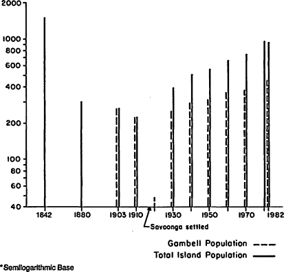
Figure 2.
Gambell and Total St. Lawrence Island Population, l30 Years (1852-1982), at Unequal Intervals*
mouth of the Yukon, is a natural hub for north-south and coast-interior trade. The river encourages traffic, and the gravel (sand-rock) spits at the mouth allow easy pedestrian travel, unlike the marshes of the mighty Yukon. Moreover, forested hills provide timber for building and firewood and places for a variety of environmental niches. The value of this location has been recognized by several waves of immigrants to the area.
The earliest known habitation in the Norton Sound region occurred at about 2000 B.C. (Dumond 1983). The earliest protracted and direct contacts by Europeans with Eskimos of the Unalakleet area occurred with the construction by Russians of Fort St. Michael (Mikhailovski Redoubt) about fifty-two miles
to the southwest in 1833 (see Ray's 1066 edition of Edmonds). This paved the way for the Russian-American Company to establish a hut for trade in Unalakleet, which it did in 1838, hiring a local native to operate it (Michael 1967; Correll 1974).
The earliest indirect contacts between Unalakleet natives and Europeans occurred much earlier. Trade networks maintained for two or more centuries linked Eskimo traders from the northern Bering Straits region to the Chukchis in Siberia and to the Eskimos along the lower Yukon and the Athapaskans in the interior. The position occupied by Unalakleet villagers was central. They traded oil to the Athapaskans of the interior for caribou skins and then traded caribou skins to the Malemiuts in exchange for peltries. The pelts, in turn, were traded to the Russians who journeyed to Siberia as early as the sixteenth century, well before the czar's sailors and explorers made their ways through the Bering Sea.
Two years before the trade hut was built in Unalakleet, the village experienced an epidemic that reduced the population from perhaps 115 to 13 inhabitants. Between 1836 and 1838, the survivors relocated from the gravel spit on the south side to the gravel spit on the north side of the river's mouth (see Michael 1967: 95-102, for Zagoskin's account of 1842).
The tiny Unalakleet population was composed of Central (mainland) Yupik speakers when the hut was erected. Because there were but thirteen survivors in the village, the Russian-American Company's representative, Zagoskin, beckoned the Malemiut from the Norton Bay region to the north to trade in Unalakleet. Many Malemiut, who spoke Inupiaq rather than Central Yupik, did so. They also stayed and colonized the village along with the remnant Yupik population.
In 1866, immediately prior to the Seward Purchase, Western Union Telegraph designated Unalakleet as its headquarters for one section of its projected transoceanic line (Whymper 1869; Dall 1870). The trading hut was operating when Western Union arrived in 1866. In less than 30 years since the Malemiuts were first beckoned by Zagoskin, the village had become the home to two groups of Inupiaq speakers—Malemiuts and Kaweraks—in addition to the local Yupiks (known as Unalits) (Whymper
1869: 167; Dall 1870: 24). Some Russian-Eskimo admixture had occurred.
Map 8 represents the pre-1836 locations identified by Edward Nelson in 1877 for the Yupik-speaking Unalit, or Unalaqlingmiut, the Malemiut, and the Kawerak (E. Nelson 1899: 24). Caribou, which had been abundant along the Norton Coast in 1840 and were an important attraction for Malemiut and Kawerak hunters and trappers in the 1840s, had disappeared from the area by 1880. This disappearance, not uncommon to caribou, which are especially prone to overpopulation and subsequent famine, occasioned a great reduction of Malemiut settlements in the Unalakleet area by 1880 as they sought meat to feed themselves and their dogs (see Burch 1975 for interpretations of the decline of resources during the period).
Nelson's (1899) massive ethnography of the several Eskimo groups around the Bering Strait focuses principally on the techniques and tools employed by Eskimos to obtain their livelihoods, provide shelter, transport themselves and their belongings, and the like. The resources harvested by Norton Sound Eskimos in the late nineteenth century were for the most part similar to the resources harvested by their forebears during the previous three millennia and to those harvested by the contemporary residents of Unalakleet. The variety of fish, land mammals, sea mammals, birds, and plants was great.
Ivan Petroff counted 100 persons in Unalakleet in 1884. Smaller settlements, such as Iktigalik, were located upriver. The Reverend Axel Karlsen established a mission in Unalakleet for the Swedish Evangelical Mission Church of America in 1887, remaining there until he died and was buried in 1910 (Correll 1974). Karlsen is credited with stifling and eventually eradicating traditional gatherings, especially plays and feasts, traditional entertainments, especially dancing and singing, and discrediting and hence eradicating shamans. He was instrumental in opening a school in 1899 (later to become the Covenant School), a ministry to service the sick and the aged, and a home for children. Karlsen also encouraged the residents of Unalakleet to develop gardens for potatoes, onions, and a wide variety of cool season, green vegetables.
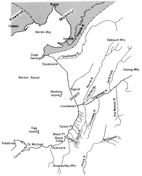
Map 8.
Distribution of Unalit (Yupik), Malemiut (Inupiaq),
and Kawerak (Inupiaq) About 1836 (from Nelson 1899)
Jackson established a reindeer herd in Unalakleet in 1894 (Stern et al. 1980). The first superintendent of the reindeer station was the Reverend Axel Karlsen. Although purchased with federal funds for natives, the herd was in the private ownership of Karlsen's church, with parts of it belonging to the 150 Lapp reindeer herders who were brought from Norway to maintain the herd and to teach local natives to become pastoralists (see Stern et al. 1980:26-36; Correll 1974: 70-72). In 1902, as many reindeer were owned by missions and other non-Eskimos in Alaska as were owned by Eskimos (Stern et al. 1980: 28).
The reindeer herds declined and were reestablished at least three times between 1894 and 1940, when the reindeer were sold to the federal government. The federal government then redistributed the reindeer to local Eskimos. The Unalakleet herd was gone by 1966. A herd remains at nearby Shaktoolik.
In 1939, the village of Unalakleet ratified a constitution under provisions of the Indian Reorganization Act as it was extended to Alaskan natives in 1988 (52 Stat. 393). A reservation was established two years later. The IRA government, converted to the village's nonprofit corporation in 1971 following ANCSA (which dissolved IRAs but allowed them to return as nonprofit corporations), has remained intact and in operation since 1939.
During World War II, a U.S. Army base was established on a hill about 3.5 miles directly north of town. The base was dismantled following the war. In the mid-1950s, a U.S. Air Force radar station was erected on 8,000 acres on a hill adjacent to the east side of town. With the advent of satellites, the station was decommissioned in a haphazard fashion in 1974 (leaving transmission towers positioned above the Unalakleet River whose cones were filled with PCBs, noxious and volatile chemicals in drums, batteries exposed on ledges, drums of oil and gasoline, and the like).
Although the military bases were self-sustaining, Unalakleet residents recalled that during the occupancies at the bases the military personnel hunted and fished in areas formerly used exclusively by natives and that during the 1950s and 1960s in
particular, they found it more difficult than previously to extract the resources that they required for subsistence. Indeed, it was recalled that the North River area was filled with military personnel and boats during the fishing season and by hunters during fall and spring. According to native informants, they requested the officers at the air base to prohibit military personnel from hunting and fishing in the area, and they complied.
Pressures on local hunting areas were not caused by military personnel alone. After World War II, residents from small villages near Unalakleet began to relocate there, while Unalakleet began to grow through natural increase as well. Between 1880 and 1910, Unalakleet's population grew from 100 to 247 (147 percent). The increase must have been due in large part to in-migration. Between 1910 and 1930, the population increased by only 14 people, to 261. The worldwide flu epidemic during that period killed many natives. Persons from smaller hamlets nearby sought refuge in Unalakleet—the reverse of the response on St. Lawrence Island.
In the period prior to World War II, Unalakleet villagers were almost entirely dependent on natural occurring resources. Shotguns and rifles had been in use locally since the 1920s and some motorized boats since the 1930s. But dog traction was the dominant form of transportation on land and paddles and human energy on water. Dogs had to be fed regularly, so their needs, too, constrained village size.
Following World War II, some Unalakleet men who had served in the military returned with modest amounts of cash and used it to buy boats for family subsistence uses but also for a nascent but intermittent commercial fishing industry.
Trucks were brought to both the army base and the radar station by the military. Subsequently, over the following twenty-five years, outboard motors became commonplace, rather than rare, and during the 1960s, snowmachines became widely used. Since the 1970s, ATCs and even trucks and cars were acquired by institutions, such as churches, schools, and the village corporation (and some persons).
Rifles and shotguns became the dominant means of securing quarry in the 1970s as weirs, traps, and snares became less popular. Traps became restricted primarily for use in acquiring
fur-beating animals. Dog ownership and use decreased, and jobs and programs made available through the village IRA government and through the Covenant Church increased the cash flow in (and out of) the local economy.
By 1950, the village population had increased to 469 from the 261 of two decades earlier. A second great spurt in village population, far outstripping an annual natural increase rate of 2.5 over twenty years, most probably occurred soon after World War II and is attributable to inmigration from the smaller hamlets nearby—Golsovia, Egavik, Klikitarik, and upriver locales.
Climbs and Plunges in the Unalakleet Population
Between 1950 and 1960, Unalakleet's population grew by about 100 people to 574, only to plunge to 434 in 1970. The much slower growth rate between 1950 and 1960 and the plunge between 1960 and 1970 can be attributed in large part to federal policies and programs. The Selective Service draft and the BIA relocation programs were most instrumental. Unalakleet residents were drafted and volunteered for military service during the Korean and Vietnam wars. The Relocation and Employment Assistance programs of the 1950s and 1960s, which were made available to Unalakleet villagers through the local IRA, provided transportation for villagers to Anchorage, Seattle, and other cities and on-the-job training when they arrived. The Employment Assistance Program focused on the relocation of entire families, not just individual trainees. These BIA programs were designed so as to permanently relocate enrolled reservation natives in urban areas where they could sever their ties with their reservation communities and be integrated into the economies of cities (see Jorgensen 1978a : 22-27).
Unalakleet children were encouraged to leave the village for additional schooling, and many did, attending the BIA's Mount Edgecombe School in Sitka (southeastern Alaska) and going on to college at Haskell Institute (Lawrence, Kansas) or the University of Alaska, often with B IA assistance or entitlements through legislation in the Johnson administration's "War on Poverty."
Alaska achieved statehood during this same period (1959),
and the Alaska Department of Fish and Game (ADF&G) assumed control of fishing and hunting throughout the state. By 1960, the commercial fisheries division of the ADF&G had determined that a profitable commercial fishery could be established in Norton Sound. That agency established some regulations encouraging natives to take part in it, which some did. Along with commercial trapping, the village had established its second commercial, market-dependent venture. Both of these economic ventures were solely dependent on the harvests of naturally occurring, renewable resources—some of the same resources on which their subsistence depended.
The Lure of a Homeland and Public Sector Benefits
If Unalakleet families and individuals were pulled or pushed from Unalakleet in the late 1950s and 1960s for military service, education, or employment through government programs, so were they drawn back to Unalakleet by the monumental force of ANCSA, work made available along the trans-Alaskan oil pipeline that followed ANCSA, the desire to use Unalakleet as home and a base of operations, and the desire to reengage in a subsistence life-style that now held the promise of some employment. Fully twenty-one years before the ratification of ANCSA, and eight years before the awarding of statehood to Alaska, Frank Degnan, a native resident of Unalakleet, was elected to the Territorial House of Representatives. When statehood was conferred in 1050, Degnan was elected to the Alaska House of Representatives. He represented Unalakleet very well, using his influence to bring state and federal programs to Unalakleet during his tenure in territorial and state government.
In large part from Degnan's work, Unalakleet benefited from new houses, sewers, electricity, and schools. These factors coalesced to make life somewhat simpler and more convenient for residents of Unalakleet, emboldened children to stay in the village beyond their public school years, and encouraged former residents to return. It also made it a prime center for secondary regional development, catching Nome's overflow.
In 1070, just prior to the passage of ANCSA, the village cen-
sus tallied 434 residents, but a decade later, that population had increased to 632, and a scant two years later, in 1982, a census taken by the city of Unalakleet put the total at 790. In our field research, we counted 200 persons who had returned to Unalakleet from locales outside the village between 1071 and 1982. All did not stay and some died, but the return rate was remarkable.
Unalakleet has had a relatively large nonnative population since 1894. These persons almost always leave the village when their employment terminates or when they retire, so some growth and decline is attributable to them. When natives return, they much more frequently stay.
What is unique is the total size of the present population. It is not dear whether the population, so dependent on naturally occurring resources for sustenance and for access to the private sector economy, can be sustained by the environment. For example, in addition to the large population, interest in dog teams has been renewed by the 1,049-mile Iditarod race, which passes through the village. Between the late 1970s and early 1980s, several dog teams were added to the village total annually. These animals require food that is, for the most part, harvested locally.
In 1971, with the passage of ANCSA, changes within the villages accelerated. Those changes of the past decade have been large and obvious in Unalakleet. New technologies have altered the daily and weekly routines and provide marked contrasts with village life of the 1960s. Four-wheel-drive vehicles are driven very short distances (about one or two city blocks), through tunnels of snow, to the grocery store, for instance. Yet the new technologies are preeminently convenient overlays to traditional society rather than the harbingers of an imminent transformation of Unalakleet society away from a subsistence base. As one village leader said, "We take whatever technology works and shape it to our own purposes and uses. . .. Apparently that bothers people who want us to remain pristine, or to admit our contradictions of wanting technology and controlling and preserving the natural resources for our own use. . .. Why not? We've always accepted and reshaped technology that works for our own purposes." This practical
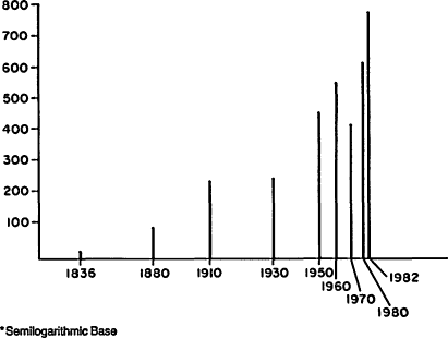
Figure 3.
Unalakleet Population, Over 146 Years (1836-1982), at Unequal Intervals*
statement addresses the question of contradiction in subsistence and technology as well as it can be addressed.
Wainwright and The North Slope
In 1848, about 900 vessels had been hunting whales south of the Bering Strait, when the Superior , under Captain Thomas Roys, became the first whaling vessel to push through the Bering Strait into the Arctic Ocean. The Superiors success touched off a rush to the Arctic Ocean the next year (Bockstoce 1978). Nonnative whalers engaged in these early activities intermarried with the Inupiat, and today many Wainwright people trace their ancestry to nonnative whalers of this period.
Demand for whale oil and other by-products, such as baleen for corsets, continued for another seventy years. Because outcroppings of coal occur near what is now Wainwright, mines were opened in the late 1880s, and natives located there to mine
the coal, which was used by the steam whalers that plied the arctic seas. The natives also began hunting, selling the meat as a commodity, to supply the whalers with food.
As late as 1881, there were at least five Inupiat settlements within a twenty-five mile radius of the Kuuk Lagoon (Murdoch 1892: 44). The inhabitants of these settlements migrated from the coast to the interior or from the interior to the coast during the seasonal changes. So there were local native populations from which laborers could be drawn to assist whaling operations, and those populations could also be educated and converted to Christianity by Christian missionaries.
Jackson sought to introduce education, Christianity, and economic self-sufficiency to Wainwrighters much as he, or his agents, had to villagers in Gambell and Unalakleet. In 1904, nearly two decades after the first disruptions from nonnative contact, the village of Wainwright became more formalized when Jackson had the federal government build a schoolhouse there (Milan 1964).
Jackson also introduced a reindeer herd into the region in 1904 (Jackson 1904). From the five or so settlements around Wainwright, Jackson enlisted the Kuugmiut people (from the environs of the Kuuk River and the coasts around Wainwright) and the Utuggagmiut (from the area around Icy Cape and the Utukok River, to the east and south of Wainwright) to manage the herd (Ivie and Schneider 1979: 76; Schneider and Libby 1979; Brostad 1975).
In 1918, Arthur James Allen, working as an agent of the H. B. Liebs Corporation, set up a whaling station and trading post at Wainwright, even though the baleen market had crumbled eleven years earlier (Gusey 1983: 75). Apparently, Allen was able to find a market because his crew operated into the 1940s, long after commercial whaling was dead and trading interests had refocused on fur trapping.
As the importance of whaling decreased in the first decade of the twentieth century, the importance of fur trading increased, only to decline during the Great Depression. But for two or three decades, it was common practice for trading posts to be operated as cooperative ventures between whites and Inupiat (Schneider and Libby 1979: 44).
The population of Wainwright rose and fell over the period from 1890 to 1970, enjoying the booms and busts of whaling, coal mining, reindeer herding, trapping, and trading fox pelts. Only Christianity and the education system endured. As figure 4 demonstrates, the population was under 100 through 1920, even though a reindeer station had been established at Wainwright in 1904. But with the expansion of the school in the early 1920s, the population grew from the immigration of families that came from small villages scattered along the Kuuk and Icy Cape regions.
A peak of 392 residents was reached in a census taken by the school in 1940. The population, including three whites, hovered in the 350 to 390 range throughout the 1940s but dropped dramatically in the late 1940s and early 1950s as about one-third of the population moved to Barrow. Recovery from the mid-1950s was slow, and by 1970, the population was still only 80 percent of what it had been in 1940.
The benefits made available to North Slope natives with the passage of ANCSA, the development of the oil pipeline, and the creation of the North Slope Borough's taxing authority occasioned an aggregate population increase of 54 percent over the following thirteen years. These population dynamics are similar to those for Gambell and Unalakleet, as we have seen.
Comparative Population Daynamics
The populations of the three villages have not been static over the past century. The worldwide influenza epidemic of 1918 affected all three village populations by drawing residents from smaller villages to larger ones (Wainwright and Unalakleet) and by temporarily dispersing the Gambell population. The colonizing of Savoonga in 1917 also added to the decline of the Gambell population. The considerable downturns in population in Wainwright (1950) and Unalakleet (1960) were stimulated by federal government programs, as were the marked upturns in all three villages after 1970. The role of public policy has weighed very heavily in the population dynamics of Eskimo villages for eighty years. The sizes of the three communities, large by comparison to most Alaskan Eskimo villages but small

Figure 4.
Wainwright Population, Over 93 Years (1890-1983), at Unequal Intervals*
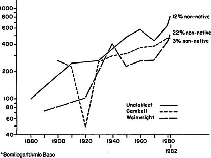
Figure 5.
Population Trend Lines, Unalakleet, Gambell, and Wainwright (1880-1982)*
in comparison to Bethel, Nome, Kotzebue, and Barrow, may be too great to allow for complete, successful reversion to total reliance on naturally occurring resources for subsistence. The growth of Gambell, although clearly accelerated by the events of the early 1970s, maintained a steadier internal rate than the growth of the other two villages between 1930 and 1970.