3
Landscapes of Memory
Sing the praises of the atmosphere, so thin and light, well-nigh as rare as the empty universal ether, free of earthly admixture whether good or bad, and even without actual sunshine to be preferred to the rank vapours of the plain.
—Thomas Mann, The Magic Mountain
Nothing soothes me so much as being alone among mountain-scenery;—it is like resting in another world.
—Sir Thomas Munro writing to his wife from Ootacamund in 1826, quoted in G. R. Gleig,
The Life of Major-General Sir Thomas Munro, Bart.
When the British first directed their gaze toward the mountainous regions of India in the early nineteenth century, what they saw was mediated by what their heritage had taught them to see. However commonplace the notion that our culture shapes our perceptions of the external world, it takes on new meaning when the object being perceived is as alien as India was to the British. The sensory impact of India would have been difficult if not impossible to process without a shared aesthetic standard against which these unfamiliar landscapes could be measured and through which they could be given meaning. As a historian of British tourism observed: "Travel . . . forces us to measure the unfamiliar by reference to the familiar: to define the experience of being abroad, we need a concept of 'home.' "[1] For the imperial sons and daughters of late Georgian and early Victorian Britain, that concept of home as a physical environment was embodied in the general notion of the picturesque.
The picturesque arose in the eighteenth century as a signifier of those scenes of nature that fulfilled certain prescriptions of beauty; these notions were derived from such varied sources as the Roman pastoral tradition, the landscapes of Claude Lorrain, and the antiquarian enthusiasm for architectural relics of the past. They became a pliant and pervasive part of the British aesthetic repertoire, especially for the growing number of persons who sought edification and pleasure in travel. Whether their journeys took
[1] Ian Ousby, The Englishman's England: Taste, Travel and the Rise of Tourism (Cambridge, 1990), 2.
them to popular sites in the British Isles or to more distant destinations, these travelers communicated much of what they saw in the language of the picturesque. Such was the case for the British who ventured into the newly accessible hinterlands of Calcutta, Madras, and other coastal enclaves in the late eighteenth and early nineteenth centuries. Their diaries and sketchbooks invariably employed the descriptive conventions of the picturesque. William Hodges, Thomas and William Daniell, and Henry Salt were particularly effective in making use of these motifs in their lithographs and paintings of India: they concentrated their gaze on scenic vistas, turbulent waterfalls and gentle rivers, dramatic rock formations, curious natural phenomena such as the banyan tree, and grand architectural monuments and ruins, all of which were meant to encourage a contemplative frame of mind.[2]
Especially noteworthy was the selectivity of this vision. The marshy deltas and densely wooded hills and semiarid plains that made up much of India rarely received aesthetic note. The scenes privileged by British pictorial and literary representation were those that conformed most closely to the conventions of the picturesque. The viewer, then, was not merely a passive receptor of natural stimuli but an active agent who channeled and processed messages in a highly selective manner. An observation by Malcolm Andrews in his study of tourism and the picturesque landscape in late-eighteenth-century Britain holds equally for the contemporaneous experience in India: the traveler was "engaged in an experiment in controlled aesthetic response to a range of new and often intimidating visual experiences."[3] The picturesque was an interpretive mechanism that allowed the British to infuse an unfamiliar geography with meaning.
Mountains held a special place within the aesthetics of the picturesque.[4] Tours through upland Wales, the Lake and Peak districts, the Scottish
[2] See Pratapaditya Pal and Vidya Dehejia, From Merchants to Emperors: British Artists and India 1757-1930 (Ithaca and London, 1986), ch. 3; Mildred Archer and Ronald Lightbown, India Observed: India as Viewed by British Artists 1760-1860 (London, 1982); Mildred Archer, Early Views of India: The Picturesque Journeys of Thomas and William Daniell 1782-1794 (London, 1980); and Jagmohan Mahajan, Picturesque India: Sketches and Travels of Thomas and William Daniell (New Delhi, 1983).
[3] Malcolm Andrews, The Search for the Picturesque: Landscape Aesthetics and Tourism in Britain, 1760-1800 (Stanford, 1989), 67.
[4] See Marjorie Hope Nicolson, Mountain Gloom and Mountain Glory: The Development of an Aesthetics of the Infinite (Ithaca, 1959).
highlands, and, further afield, the Pyrenees, Tuscany, and the Alps had nourished an appreciation for highland views among the British. There is a dramatic difference, however, between the gentle green hills of Wales and the sheer rock massif of the Alps, a difference not merely of scale but of signification. Among the archetypal images of the picturesque is the pastoral one of verdant rolling hills with cottages nestled in the vales and sheep grazing on the slopes under the drowsy care of shepherds. The representational expectations of visitors to Wales and other highland parts of Britain were suitably served by this bucolic imagery, but it proved entirely inadequate for the encounter with environments as severe and imposing as the Alps. These places demanded a different aesthetic response. Hence the evocation of the sublime, a term that referred to the intense and ambivalent emotions that arose when one confronted nature at its most untamed. Because of their overwhelming immensity, great mountain ranges like the Alps aroused awe and fear in the observer. Such feelings alarmed most Georgian travelers, who preferred to pass through the Alps as quickly as possible, but the Romantic sensibility of the late eighteenth and early nineteenth century led many to embrace the sublime, to seek out bleak environs and savor the intense emotions they inspired. The British carried this aesthetic stance abroad. As a result, those who visited the mountain regions of India were equipped to respond in two distinct registers. The picturesque could be called upon when the surroundings resembled the gentle pastoral highlands of Britain, while the sublime existed to express the conflicting feelings of fear and rapture that arose from the sight of such imposing and unfamiliar terrain as the Alps.
The topography of the Nilgiris and other highland regions of central and southern India consisted for the most part of gently rolling, sparsely wooded plateaus bounded by steep escarpments, a tractable terrain that fitted easily within the pastoral conventions of the picturesque. One of the first accounts of the area around Ootacamund proclaimed it to be "the most picturesque spot," explaining that "the hills throughout the interior present a softened outline and a rounded form, a succession of gentle swells and easy eminences. . . . A thousand streams of crystal clearness . . . preserve the perennial freshness of the wooded vales." Another early visitor to the region evoked the poetry of William Wordsworth and the paintings of Claude Lorrain and Nicholas Poussin in his descriptions. The landscape, he thought, "looked as if it had once been liquid and in the midst of some mighty storm, its waves had been solidified, and all its gulfs and surges perpetuated in the billowy agitation." Romantic rhetoric even infiltrated the supposedly dispassionate reports of medical authorities. "It is difficult
to find appropriate terms to convey an accurate description of these singularly smooth, rounded and undulating hills," gushed the Madras medical board in its report on the Nilgiris. "They present truly a 'surging scene' to use an expression of Coleridge, resemble the billows of the sea suddenly stilled, solidified and fixed, while in their full career of heaving commotion." As this recurrent use of sea imagery suggests, water in motion was an evocative symbol of the natural world to British sensibilities, and few scenes were more privileged by the picturesque than waterfalls. The Nilgiris proffered the popular Kalhatti falls and several other cascades for the British to admire. "A cataract rolling down in the centre of the chasm completes the grandeur of the scene," pronounced one visitor, "conveying that unfailing delight which the fall of rushing water affords in every part of the world." (The iconoclastic Richard Burton, who ridiculed the rhetoric of the picturesque, was less impressed, remarking dryly that the waterfalls of the Nilgiris "only want water.")[5]
The language used to describe highland territory elsewhere in the peninsular and central portions of the subcontinent was similarly imbued with the motifs of the picturesque. An officer sent to explore the Annamullay mountains south of the Nilgiris wrote about "undulating grassy hills, wooded vallies [sic], rocky crags, overhanging precipices, [and] . . . green fields." The first Englishman to visit the plateau in the Central Provinces where the hill station of Pachmarhi would arise wrote with feeling about its cool climate and striking vistas, and the authors of the district gazetteer described the scenery as "a maze of gorges and ravines, sometimes picturesque, and sometimes of great grandeur." Even the relatively unimposing highland terrain in the vicinity of Bombay inspired visitors to flights of lyricism. One of the earliest officials to view Mahabaleshwar asserted that the "scenery from many positions is both grand and romantic, reminding one of old England." Another spoke somewhat
[5] Major William Murray, An Account of the Neilgherries, or, Blue Mountains of Coimbatore, in Southern India (London, 1834), 52; Capt. Robert Mignan, Notes Extracted from a Private Journal, Written during a Tour through a Part of Malabar, and among the Neilgherries (Bombay, 1834), 63; Medical Board Office, Madras Presidency, Report on the Medical Topography and Statistics of Neilgherry Hills (Madras, 1844), 2-3; Lt. H. Jervis, Narrative of a Journey to the Falls of the Cavery with an Historical and Descriptive Account of the Neilgherry Hills (London, 1834), 36-37; Richard F. Burton, Goa, and the Blue Mountains (1851; reprint, Berkeley, 1991), 270. The journal of the medical officer who in 1824 investigated the Nilgiri and Shevaroy ranges as locations for sanitaria was, not surprisingly, "thickly sprinkled with quotations from English poets and Virgil," according to Sir Frederick Price, Ootacamund: A History (Madras, 1908), 26.
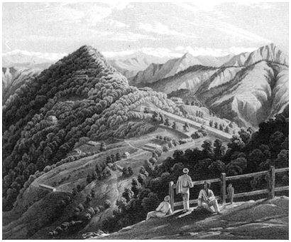
Figure 2.
Representing the hill station as a site of the picturesque: an early view of Simla from W. L. L. Scott's
Views in the Himalayas . Courtesy of the British Library, Oriental and India Office Collections.
hopefully of the location's "Alpine grandeur," then modified the analogy with a description of the "waving hills with the mellow tints of autumn under an Italian sky."[6]
Pictorial representations of these mountain sites communicated similar sentiments (Figure 2). A dozen or more volumes of engravings and lithographs portraying various parts of the Indian highlands were published in the early to middle part of the nineteenth century. Nearly all were the work of British East India Company officers, who were often skilled draftsmen.
[6] Lt.-Col. Douglas Hamilton, Report on the High Ranges of the Annamullay Mountains (Madras, 1866), 7; Capt. J. Forsyth, The Highlands of Central India (London, 1871), 85; G. L. Corbett and R. V. Russell, Central Provinces District Gazetteers: Hoshangabad District , vol. A (Calcutta, 1908), 333; Peter Lodwick to the Bombay Courier , 1 May 1824, in Perin Bharucha, Mahabaleswar: The Club 1881-1981 (Bombay, c. 1981), app. A; James Murray, Account of Malcom Pait, on the Mahableshwur Hills (Bombay, 1863), 22, 25.
Training in topographical and architectural drawing was standard at the company's military cadet schools, and Haileybury, the training college for company civil servants, employed professional artists to teach its students drawing and watercolor painting.[7] The artistic maxims absorbed in these institutions came into play when officials began to portray the highland landscapes that had come within their domain. Their efforts invariably followed the compositional conventions of European topographical drawing and landscape painting (although the professional artists who turned the sketches into engravings and lithographs certainly played some role in accentuating these picturesque qualities).[8] Most of the images were panoramic views, frequently framed by trees or other devices in the foreground that accentuated the scope and grandeur of the scene. Among the favorite subjects were lakes and wooded valleys nestled among the hills, with ranges of peaks or the hot plains receding in the distance. A stag, an Indian herdsman, or a British couple admiring the view often added pastoral flavor to the scene. Interspersed among these panoramas were more intimate tableaux of striking rock formations, waterfalls, and other motifs of the picturesque.[9] Mildred Archer, the leading authority on British Indian art, believes that Captain Richard Barron's drawings of the Nilgiri hills evoke "a peaceful charm reminiscent of Samuel Palmer's views of Shoreham Valley in Kent," and she observes that the mountains appeared "as a Garden of Eden" in much of this work.[10]
[7] Archer and Lightbown, India Observed , 12; Pal and Dehejia, From Merchants to Emperors , 14.
[8] Richard Burton, for one, was suspicious of the interventions of professionals: "I have been able . . . to illustrate my own books. It is only in this way that a correct idea of unfamiliar scenes can be given. Travellers who bring home a few scrawls and put them in the hands of a professional illustrator, have the pleasure of seeing the illustrated paper style applied to the scenery. . . . Even when the drawings are carefully done by the traveller-artist, it is hard to persuade the professional to preserve their peculiarities." Isabel Burton, The Life of Captain Sir Richard F. Burton , vol. 1 (London, 1893), 61.
[9] See Capt. Richard Barron, Views in India, Chiefly among the Neelgherry Hills (London, 1837); H. L. Frazer, Views of the Neilgherries (Calcutta, 1856-57); Lt.-Col. James Fullerton, Views in the Himalaya and Neilgherry Hills (London, c. 1848); Lt.-Col. Douglas Hamilton, Sketches of the Shevaroy Hills (London, 1865); Major E. A. McCurdy, Three Panoramic Views of Ootacamund (London, c. 1830); Capt. E. A. McCurdy, Views of the Neilgherries, or Blue Mountains of Coimbetoor (London, c. 1830); Alicia Eliza Scott, Simla Scenes Drawn from Nature (London, c. 1846); W.L.L. Scott, Views in the Himalayas (London, 1852); and Capt. George Powell Thomas, Views of Simla (London, c. 1846).
[10] Archer and Lightbown, India Observed , 108.
The sublime rather than the pastoral, however, was the ambiance that early British travelers usually associated with the Himalayas. The sheer size of these mountains set them apart from the ranges to the south: by the early nineteenth century, the British knew that the highest peaks in the world could be found here, although their full measure remained underestimated. George Francis White's Views of India, Chiefly among the Himalaya Mountains (c. 1838) is in many ways characteristic of the initial British response to this soaring scenery. The book is an account of his journey with several friends through the western Himalayas, and it includes a number of handsome lithographs made from his drawings. White's self-proclaimed "ardour in pursuit of the picturesque" pervades the text. From a distance, "the mountain ranges have all the indistinctness which belongs to the land of the faerie, and which, leaving the imagination to luxuriate in its most fanciful creations, lends enchantment to the scene." But on closer inspection "the mind is almost overpowered with astonishment, which, as we survey the gigantic wonders of the scene, is not wholly unmixed with a sensation allied to fear." Indeed, fear is an appropriate response to "a land whose savage aspect was seldom redeemed by scenes of gentle beauty."[11] To tour this unwelcoming land, to experience this fear, was to be presented with a salutary reminder of how puny human beings were when measured against the raw forces of nature.
Herein lay the essence of the sublime, and it pervaded the rhetoric of early British travelers to the Himalayas. Bishop Heber, who visited the Kumaun area in 1824, wrote in his journal that "everything around was so wild and magnificent that man appeared as nothing, and I felt myself as if climbing the steps of the altar of God's great temple."[12] The pseudonymous "Pilgrim" (P. Barron), who wandered through the same area in the early 1840s, was equally affected by his surroundings:
On [the Himalayas] the eye never wearies to dwell—it affords a kind of enjoyment which springing from the purest of all sources, the fountain head of nature, has a tendency to elevate the feelings of the mind, and to exclude from it the workings of all ungenerous and turbulent passions. . . . [A] feeling from time to time creeps over you, of shrinking from your own insignificance, in the presence of such examples of the stupendous might and power of the great architect of the universe. What an atom in its system a human being appears; and how humiliated you feel, at having ever
[11] Lt. George Francis White, Views in India, Chiefly among the Himalaya Mountains , ed. Emma Roberts (London and Paris, c. 1838), 38, 19, 32, 40.
[12] Bishop Heber, Bishop Heber in Northern India: Selections from Heber's Journal , ed. M. A. Laird (Cambridge, 1971), 216.
expected that the gratification of your insignificant desires and wishes could have been anything else but dust in the Balance, to the Creator of works like these.[13]
The British, not unlike the Indians they ruled, felt themselves closer to the gods in these mountains and humbled by the proximity. Given, however, the purposes that these high places were increasingly intended to serve—that is, as sites for sanitaria—there was something problematic about the aesthetics of the sublime. To feel dwarfed and overawed by the untamed forces of nature may have been emotionally edifying for the passing traveler, but it was intensely disturbing to the invalid or other sojourner trying to find sanctuary from the plains. Such respite necessitated a landscape that had been tamed of its danger and reduced to human proportions, which is to say a landscape that had been made picturesque. The war correspondent of the London Times , William Howard Russell, made this point during a convalescent stay in Simla: "The landscape suffers from . . . the magnitude of the scale in which it is cast, and it is only by minute and accurate analysis that one comprehends its vastness."[14] The sublime was simply not suited to the purposes of residence. The mountain landscape, or more precisely those of its selected pockets within which hill stations were established, had to be brought within bounds, subdued and domesticated, if it were to serve those who sought physical or psychic relief from the pressures of the colonial tropics.[15]
Partly for this reason, perhaps, the sanitaria established in the Indian highlands became known as "hill stations." To use the word hill to refer to stations balanced precariously on the edges of ridges some six to eight thousand feet in elevation seems, on the face of it, a rather odd choice of terminology. It has been argued that the Himalayan stations seemed as though they were situated on little more than hills because they were set against the backdrop of the high country.[16] But the universal adoption of the term hill station for highland sanitaria also suggests an etymological effort to minimize the disturbing implications of the sublime. It should be
[13] "Pilgrim" [P. Barron], Notes of Wanderings in the Himmala (Agra, 1844), 47.
[14] William Howard Russell, My Diary in India , vol. 2 (London, 1860), 105.
[15] Although the context is quite different, the threat of the sublime became a preoccupation for William Wordsworth, who attempted in his later years to develop an aesthetic for its "containment," according to Theresa M. Kelley, Wordsworth's Revisionary Aesthetics (Cambridge, 1988), ch. 6.
[16] See Fanny Parks, Wanderings of a Pilgrim, in Search of the Picturesque , vol. 2 (London, 1850), 228.
noted, for instance, that the Nilgiris were initially described as "mountains" in official reports, but once John Sullivan and others had established permanent residence there, they quickly became "hills." To speak of hill stations rather than mountain stations rhetorically scaled back the overwhelming force of the landscape.
Domesticating the environs of hill stations required not merely a change in terminology but an intervention in the physical world itself. It began, appropriately enough, with the garden, that ancient symbol of peace and refuge where people sought harmony with nature. From the start, hill stations were centers of horticultural experimentation and emendation. The British were delighted to discover that many of the flowers, fruits, and vegetables popular in Britain flourished in the cool mountain climate. Roses, geraniums, fuchsias, lilies, dahlias, heliotropes, buttercups, sweet peas, bluebonnets, and other popular flowers soon graced the grounds of highland cottages and spread through the surrounding countryside. Experimental fruit orchards and vegetable gardens brought forth a cornucopia of cabbages, cauliflowers, lettuce, turnips, parsley, strawberries, apples, pears, plums, and other familiar produce. It has been claimed that the first English apple tree to be transplanted into Indian soil was nurtured in Mussoorie. "Violets, buttercups, wild strawberries and raspberries, and many other old friends abound," wrote Lady Lawrence to her husband from Simla in 1839. "Every house has its garden," a visitor to the Nilgiris effused, "and the verandahs are bowery with trailers, and creepers. . . . Fruit trees also abound, especially the peach, and we have plenty of strawberries, and also home vegetables." More pointedly, a midcentury guide to Darjeeling stated: "Many common English wild flowers bring back to memory the hills and dales and shady nooks and lanes of the fatherland." Memories of England, of course, were central to these horticultural activities.[17]
The casual efforts of individuals to transform the flora of the hill stations were reinforced by the concerted actions of the state. Government nurseries and botanical gardens were established in a number of hill stations to test potential cash crops and to provide local residents with seeds and plants. The venerable Calcutta Botanic Garden, founded in 1786-87, was emulated
[17] Lady Lawrence quoted in Sir Herbert Benjamin Edwardes and Herman Merivale, Life of Sir Henry Lawrence , 2d ed., vol. 1 (London, 1872), 210; Mrs. Murray Mitchell, In Southern India (London, 1885), 351, 354; Darjeeling , pamphlet reprinted from Calcutta Review , no. 55 (1857): 14.
with particular success in Darjeeling and Ootacamund.[18] The Lloyd Botanical Garden, named after its founder, the official who had negotiated the deed that ceded Darjeeling to the British, covered fourteen acres just below the central portion of the station. The fifty-four-acre Government Botanical Garden at Ootacamund was established in 1848 along the slopes of Dodabetta peak, the highest location in the area. The two gardens played important roles in the development of tea, coffee, cinchona, and other commercial crops, but they also served as pleasure parks for station residents and supplied them with flower and vegetable seeds, cuttings from ornamental shrubs, and shade and fruit trees. Only a few years after its founding, the government garden at Ootacamund was offering for sale fifty-three varieties of apple trees.[19] (Darjeeling was less kind to apple trees and the like: the garden's director concluded in 1886 that the place was "pretty nearly hopeless as a home for any European fruit, except the strawberry."[20] ) One of the central aims of the botanical gardens was to make the landscape less alien, to give it a more recognizable and pleasing appearance to those for whom it became a sanctuary.
These gardens held a deeper meaning for the British mentalité . European botanical gardens originated in the sixteenth and seventeenth centuries as a result of the discovery of the New World and its flora; they attempted to draw together representative samples of the entire plant kingdom in a new Garden of Eden.[21] While any serious hopes of achieving such a comprehensive collection had been abandoned by the nineteenth century, botanical gardens retained symbolic associations with Eden. Those who strolled along the secluded paths in the Darjeeling and Ootacamund gardens sought the sense of peace and purity that the Christian faith identified with the original home of Adam and Eve.
While the botanical gardens at Ootacamund and Darjeeling were exceptionally large and important, a number of other hill stations had public gardens and nurseries that served local needs. There was one in Mussoorie
[18] See Edward W. Ellsworth, Science and Social Science Research in British India, 1780-1880 (New York, 1991), ch. 6; and Daniel R. Headrick, The Tentacles of Imperialism: Technology Transfer in the Age of Imperialism, 1850-1940 (New York, 1988), ch. 7.
[19] Report on the Government Botanical and Horticultural Gardens, Ootacamund, for the Year 1854-55 (Madras, 1856), Appendix.
[20] "Annual Report of Royal Botanic Gardens for Year 1885-86," July 1886, Medical Branch, Municipal, Proceedings of the Lieutenant Governor of Bengal, WBSA.
[21] See John Prest, The Garden of Eden: The Botanic Garden and the Recreation of Paradise (New Haven, 1981).
as early as 1827, and by the latter part of the century the station had two botanical gardens. Simla's municipal government established a nursery at Annandale, a large, level glade directly below the main ridge of the station, where plants, flowers, and fruit trees were sold to the public in the late nineteenth and early twentieth centuries. Coonoor had the much admired Sim's Park, a thirty-acre public garden founded in 1874. Panchgani was the site of a government nursery, and the visitor Margaret Denning claimed that it sent "every day a basket of fresh fruit and vegetables . . . to every house." The Chaubattia fruit garden near Ranikhet grew apples, pears, peaches, apricots, plums, cherries, sweet chestnuts, quince, currants, gooseberries, figs, mulberries, strawberries, and blackberries on its fifty acres, and it offered seedlings and grafts for sale. Several experimental fruit orchards were scattered across the Nilgiris. Each of these gardens dispersed European plants to local residents, helping to transform the local environments in such a way that they became like home for the British.[22]
In the Himalayan stations, efforts to transform the landscape seldom went beyond these horticultural interventions; the rugged ridges prevented much more. For instance, even though the British regarded lakes as an important feature of the picturesque landscape, and even though, as was demonstrated on English country estates, they were willing to dig artificial lakes where natural ones did not exist, none of the Himalayan resorts possessed the topography suitable for such a project. (Naini Tal had the rare distinction of a natural lake.) "Everybody who has visited the hills," noted George White, "regrets the absence of those large bodies of water which alone are wanting to fill up the coup-d'oeil."[23]
In the less perpendicular terrain of India's central and southern highlands, however, hydraulic engineering of this sort was undertaken with great gusto. At Ootacamund, Sullivan dammed a stream running through the valley in 1823, thereby creating the lake that became the station's most celebrated feature. "This beautiful piece of water," wrote one enraptured visitor, "winds in a serpentine course among the hills, gently rising from its bands, and clothed with the softest verdure, . . . affording one of the
[22] Edwin T. Atkinson, The Himalayan Gazetteer , vol. 3, pt. 1 (1882; reprint, Delhi, 1973), 601; Annual Report of the Simla Municipality, 1887-88, HPSA; W. Francis, The Nilgiris (Madras, 1908), 206; Gazetteer of the Bombay Presidency , vol. 19: Satara (Bombay, 1885), 534; Margaret B. Denning, Mosaics from India (Chicago, 1902), 199; H. G. Walton, Almora: A Gazetteer , vol. 35 (Allahabad, 1911), 25; Madras District Gazetteers, Statistical Appendix for the Nilgiri District (Madras, 1928), 45-47.
[23] White, Views in India , 40.
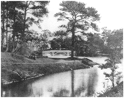
Figure 3. The artificial lake at Shillong. From Eastern Bengal State Railway,
From the Hooghly to the Himalayas (Bombay, 1913).
most scenic, healthful, and agreeable drives of which India, or perhaps any part of the world, can boast."[24] Artificial lakes were created with similar intent at the hill stations of Kodaikanal, Mahabaleshwar, Matheran, Panchgani, Shillong (Figure 3), Wellington, and Yercaud.
So popular were lakes as an aesthetic improvement to the hill station's landscape that at least one intrepid investigator made the mirage of a lake the central feature of his geographical report. When Lieutenant-Colonel (later General) Douglas Hamilton informed the Madras government of his search for a convalescent site in the Palni mountains of southern India, he described the place he considered best suited for such a station as being located near a lake. As the report progressed, however, it became clear that what Hamilton initially had termed a lake was no such thing: it was a valley where he thought he detected evidence of an ancient lake bed. The distinction seemed scarcely worthy of note to Hamilton, so persuaded was he that this location offered the most picturesque environment for a settlement. "Let but the lake be reconstructed and a road made to it, and this
[24] Capt. Henry Harkness, A Description of a Singular Aboriginal Race Inhabiting the Summit of the Neilgherry Hills (London, 1832), 5.
magnificent sheet of water . . . will of itself attract residents to its vicinity."[25] Paul Carter has observed with reference to colonial Australia that British explorers sometimes described features of the landscape as rivers or mountains when these terms were inappropriate. He finds in this practice an effort "to differentiate the landscape," and the effect was less to describe places than to invent them. "Geographical class names . . . rendered the world visible, bringing it within the horizon of discourse."[26] Hamilton's imaginary lake represents an invention of just this sort. It distinguished a particular place within the Palni hills, rendering it visible as a site for a convalescent station. This incident in linguistic invention, in turn, helps us to understand that the lakes which appeared at Ootacamund and elsewhere were inventions as well, introduced by the British as part of their effort to reshape the landscape so that it would conform to their cultural expectations.
The result was to domesticate the disorderly, to familiarize the unfamiliar, to model these highland spaces in the likeness of favored landscapes at home. The climate and flora of Darjeeling "recalled that of England" for Joseph Hooker, while Ootacamund made the same impression on Macaulay. Captain George Thomas compared the summer months in Simla to an "English spring . . . [with a] thousand English blossoms." The environs of Naini Tal were described as "the Westmoreland of Kumaun." An Eastern Bengal State Railway brochure suggested that Shillong was like "parts of Hampshire and Surrey"; an agent for tea planters compared it to "Surrey or Cotswold Hills." Pachmarhi was said to resemble "a fine English park." Ootacamund seemed like "Malvern at the fairest season" to the Bishop of Calcutta, "some sweet spot in the Scottish Highlands" to the missionary John W. Dulles, and "the mountains and hills of Cumberland and Westmorland" to the sports-woman Isabel Savory. For Lord Lytton, viceroy of India, it was "a paradise. . . . The afternoon was rainy and the road muddy, but such beautiful English rain, such delicious English mud. Imagine Hertfordshire lands, Devonshire downs, Westmoreland lakes, Scotch troutstreams, and Lusitanian views!" Similarly, Mussoorie reminded Fanny Parks of the Isle of Wight and caused her to exclaim: "How delicious is this coldness in the Hills!—it is just as wet, windy, and wretched as in England." A paternalistic army surgeon who advocated the billeting of British troops in hill stations believed that the Himalayas in general would stir memories of home for the army's Celtic ranks: "those Scotch and Irish soldiers who
[25] Lt.-Col. Douglas Hamilton, Report on the Pulni Mountains (Madras, 1864), 4.
[26] Paul Carter, The Road to Botany Bay: An Essay in Spatial History (London, 1987), 50, 51.
constitute so large a portion of the British army would find in the Himalayas a soil and sky not much different from their own, they would here feed upon food and vegetables like those they were accustomed to at home, and be brought into daily contact with a simple race . . . who delight in the sound of a pipe which closely resembles the wild minstrelsy of their own native glens."[27]
Over time, hill stations were drawn so tightly within the aesthetic confines of British landscape traditions that they became divorced from the surrounding environment, particularly when that environment was as intimidating as the Himalayas. Within the stations the natural world had been cut to human scale, so that luxuriant gardens and quaint cottages, thick stands of trees and wide pedestrian malls, meandering lanes and shimmering lakes all existed in harmonious juxtaposition. Beyond the stations loomed nature in the raw, an elemental force, its scale and strength dwarfing humankind. Increasingly, those who wished to savor the thrill of the sublime had to do so outside the confines of the hill station. Guidebooks directed visitors to distant sites where they could gaze upon snow-capped peaks, torrent-worn gorges, and other natural wonders. Even though breathtaking vistas were available from the centers of many hill stations, the British inhabitants privileged sights that stood beyond municipal boundaries, designated places that received evocative names and attracted organized parties. Within the stations' confines, inhabitants' vision tended to narrow, focusing on flower-bedecked homes comfortably nestled along hillsides or upon the shores of artificial lakes.
By their very nature, representations give an oblique reading of the objects they represent, a frame of reference that furthers the ends of those who set its parameters and that imposes their intentions on the image. The
[27] Joseph Dalton Hooker, Himalayan Journals , vol. 1 (London, 1854), 109; Thomas Babington Macaulay, Letters , vol. 3 (Cambridge, 1976), 58, 59; Thomas, Views of Simla , 5 (emphasis in original); H. R. Neville, Naini Tal: A Gazetteer, Being Volume XXXIV of the District Gazetteers of the United Provinces of Agra and Oudh (Allahabad, 1904), 12; Eastern Bengal State Railway, From the Hooghly to the Himalayas (Bombay, 1913), 47; Hyde Clarke, "The English Stations in the Hill Regions of India," Journal of the Statistical Society 44 (Sept. 1881): 532; Forsyth, Highlands of Central India , 85; Bishop of Calcutta quoted in Jervis, Narrative of a Journey , 20; Rev. John W. Dulles, Life in India; or Madras, the Neilgherries, and Calcutta (Philadelphia, 1855), 441; Isabel Savory, A Sports-woman in India (London, 1900), 330; Lord Lytton quoted in Lady Betty Balfour, The History of Lord Lytton's Indian Administration, 1876 to 1880 (London, 1899), 220 (emphasis in original); Parks, Wanderings of a Pilgrim , vol. 2, 229, 239; William Curran, "The Himalayas as a Health Resort," Practitioner (Jan. 1871): 42.
pleasant picture that the British painted of hill station landscapes and the collateral program they undertook to make the environment even more picturesque disguised a complicated and troubling reality. Although the British did indeed transform the environs of hill stations, this transformation did not accord entirely with their ideals. One of the foremost environmental repercussions of their entry into the highlands was deforestation.
The assault on the forests began in the early nineteenth century with the growth of a commercial market for timber.[28] The Kumaun/Garhwal region was one of the earliest centers for the cutting of timber for export to the plains: from the 1820s onward visitors to Mussoorie, Almora, and surrounding areas remarked upon the denuded hillsides.[29] After midcentury the railroad-construction boom produced an enormous demand for wood for use as railway ties. Entire forests of sal and other trees disappeared from the Himalayan foothills. The contemporaneous introduction of tea and other plantation crops to Darjeeling, Assam, and the Nilgiris led to the massive clearing of wooded tracts in these regions. The Darjeeling district gazetteer stated in 1876 that "the forest has almost entirely disappeared in many parts, owing to the spread of cultivation."[30] The demand for fuel and building material by the growing populations of the hill stations also contributed to the problem. Local stands of trees quickly fell to the axes of the founding residents, and encroachments on surrounding timber areas intensified as the stations expanded. Simla consumed some 85,000 cubic feet of timber per year toward the end of the nineteenth century. During the station's great public-construction boom of the 1880s the figure reached 250,000 cubic feet per year.[31]
[28] The leading authority on this topic is Richard P. Tucker, whose work includes "The British Colonial System and the Forests of the Western Himalayas, 1815-1914," in Global Deforestation and the Nineteenth-Century World Economy , ed. Richard P. Tucker and J. F. Richards (Durham, 1983), 146-66; and "The Depletion of India's Forests under British Imperialism: Planters, Foresters, and Peasants in Assam and Kerala," in The Ends of the Earth: Perspectives on Modern Environmental History , ed. Donald Worster (Cambridge, 1988), 118-40. For a useful overview of the British impact on colonial forest lands, see Richard H. Grove, "Colonial Conservation, Ecological Hegemony and Popular Resistance: Towards a Global Synthesis," in Imperialism and the Natural World , ed. John M. MacKenzie (Manchester, 1990), 15-50.
[29] Heber, Bishop Heber , 221; "Pilgrim," Notes of Wanderings , 128, 165; and "Mountaineer," A Summer Ramble in the Himalayas (London, 1860), 4-5, 13.
[30] W. W. Hunter, A Statistical Account of Bengal , vol. 10: Districts of Darjiling and Jalpaiguri, and State of Kuch Behar (London, 1876), 19.
[31] Report by Lalla Chajju Ram, municipal forest ranger, to Simla Municipality, 5 Sept. 1894, Simla Municipal Proceedings, vol. 6, 1893-94, HPSA.
Adding to the commercial or developmental pressures on the forests was the conviction—widely held by the British in the first half of the nineteenth century—that illness lurked in thick stands of indigenous growth. Even though most hill stations were believed to be above the so-called fever zone, many authorities insisted on a prophylactic policy of clearing out brush, trees, and other "vegetative matter" that might harbor disease. In Darjeeling, for example, the presence of a small fly with an irritating bite caused officials in the late 1830s to recommend that most of the trees within the station be cut down.[32] A medical officer who arrived shortly thereafter found that the summit had indeed been cleared. In his opinion, this improved the view, but he felt that still more vegetation needed to be removed.[33] In Mussoorie, where commercial demand had wiped out the forests, Thornton's Gazetteer concluded that "the injurious effect to the scenery has been more than compensated by increased salubrity."[34]
Others, however, lamented the disappearance of the forests, and their influence grew as the depredations increased. One reason they objected was aesthetic: chopping down all the trees around a hill station made it difficult to sustain the illusion that residents were nestled in the picturesque bosom of nature. Another reason was pragmatic: the destruction of forest cover caused erosion and landslides. They were also increasingly convinced that deforestation caused a rise in temperatures and a decline in rainfall.[35] A visitor to the Nilgiris expressed this concern about the climatic effects of deforestation as early as 1834. It gradually gained currency and by the latter part of the century was offered to explain such phenomena as the apparent increase in summer temperatures in Mahabaleshwar and Mussoorie and the diminution in winter snowfall at Darjeeling.[36] Lastly, the medical
[32] Letters and a memorandum by Capt. G. A. Lloyd and Surgeon Henry Chapman, 19 June 1837, no. 39, Foreign Dept. Proceedings, INA.
[33] J. T. Pearson, "A Note on Darjeeling," 1839, reprinted in Fred Pinn, The Road to Destiny: Darjeeling Letters 1839 (Calcutta, 1986), 101.
[34] Quoted in Hyde Clarke, Colonization, Defence and Railways in Our Indian Empire (London, 1857), 101.
[35] The origins and spread of this "dessication" theory are traced by Richard Grove, "Conserving Eden: The (European) East India Companies and Their Environmental Policies on St. Helena, Mauritius, and in Western India, 1660 to 1854," Comparative Studies in Society and History 35, no. 2 (April 1993): 318-51.
[36] Mignan, Notes Extracted from a Private Journal , 137; J. C. Lisboa, "Short Notes on the Present Altered Climate of Mahableshwar and Its Causes," in Roa Bahadur D. B. Parasnis, Mahabaleshwar (Bombay, 1916), app. 2; N. M. Dastur, Pocket Book of Mahabaleshwar and Panchgani (Poona, 1944), 47-48; H. G. Walton, Dehra Dun: A Gazetteer, District Gazetteers of the United Provinces of Agra
and Oudh , vol. 1 (Allahabad, 1911), 216; and Col. G. B. Mainwaring, A Grammar of the Rong (Lepcha) Language (1876; reprint, Delhi, 1985), xviii n.
rationale for removing trees from stations began to weaken around midcentury. John Strachey, writing in 1861, deplored the "mischief" that had been caused in both the hills and the plains by "the ignorant notion which is so commonly prevalent that trees are prejudicial to health."[37] Quite the reverse came to be viewed as true. "Careful protection of existing trees," insisted the Simla Municipality, "and planting in vacant spaces are considered very necessary to maintain and improve the beauty and salubrity of the station."[38] By the second half of the nineteenth century, it was the absence rather than the presence of trees that aroused anxiety.
As the adverse effects of deforestation became increasingly apparent, a conservationist impulse took shape that would profoundly affect the physical appearance of hill stations.[39] Even in the early years some efforts had been made to conserve woodland: both Simla and Ootacamund had regulations in the 1830s requiring residents to obtain approval from local authorities before they felled trees, and Ootacamund title deeds included a provision that owners plant a sapling for every tree they removed.[40] However, these regulations do not appear to have been rigorously enforced. Only after midcentury did the forests come under some real measure of protection. In 1852 a European forester and six Indian assistants were appointed to patrol the Nilgiri woodlands and prevent over-cutting.[41] The authorities at Mahabaleshwar established a five-mile forest-conservancy zone around the station in 1853.[42] In 1856 the commissioner of Kumaun, Henry Ramsay, issued an order prohibiting the indiscriminate felling of trees in his district.[43] And in 1865 the trees within a five-mile radius of the center of Darjeeling were protected under new rules.[44] These and other
[37] Selections from the Records of the Government of India (Military Department) , no. 3: Report on the Extent and Nature of the Sanitary Establishments for European Troops in India (Calcutta, 1861-62), 98
[38] Annual Report of the Simla Municipality, 1882-83, 17, HPSA.
[39] For the background to this conservationist impulse, see Grove's articles "Conserving Eden" and "Colonial Conservation."
[40] Capt. Kennedy to Col. Stevenson, 13 May 1831, no. 4, Political Proceedings, Foreign Dept., INA; Francis, Nilgiris , 210.
[41] Capt. J. Ouchterlony, Geographical and Statistical Memoir of a Survey of the Neilgherry Mountains (Madras, 1868), 70; Francis, Nilgiris , 210.
[42] Gazetteer of the Bombay Presidency , vol. 19: Satara , 496.
[43] A. S. Rawat, "Henry Ramsay: The Uncrowned King of Kumaon," in Himalaya Frontier in Historical Perspective , ed. N. R. Ray (Calcutta, 1986), 184.
[44] E. C. Dozey, A Concise History of the Darjeeling District since 1835 (Calcutta, 1922), 165.
local initiatives culminated in an India-wide policy of forest conservancy. The first inspector-general of forests was appointed in 1865, and his powers were broadened with the passage of forestry legislation in 1878, which allowed the state to place extensive tracts of forest under its protection and management.[45] By the end of the century, many hill stations were encircled by belts of protected forest administered either by the Forestry Department or by the stations themselves. In Simla, for example, the municipality assumed management of 2,115 acres of local forest in 1889, and it succeeded in doubling this protected acreage within a decade.[46]
These forest reserves served both aesthetic and practical purposes. The Simla gazetteer explained: "The primary object of management, especially in those parts which are visible from the main roads, is to preserve the beauty of the station by the maintenance of ornamental high forest; while at the same time, and as far as is compatible with that object, the forest must be made to yield as large a supply as possible of timber for municipal works and fuel for the general market."[47] Unlike the great tracts of territory administered by the Forestry Department, which were managed with commercial usage foremost in mind, the forest reserves that lay within the orbits of the hill stations were intended above all to accentuate the picturesque qualities of the surroundings. This goal did not, however, prohibit the carefully regulated sale of grass, firewood, and timber, which provided welcome revenue to the local governments. Nor were the administrators of municipal forests any more responsive to the interests of the indigenous communities than were administrators of other forest reserves: both abrogated peasants' customary rights to fodder, fuel, and other forest products because these rights were said to pose an environmental threat.[48]
Deforestation was so extensive on the slopes surrounding some hill stations that the preservation of surviving stands was not enough—an extensive program of replanting native and new species of trees was necessary to repair the damage and to meet the demand for firewood and building timber. Widely scattered initiatives by amateur horticulturists gradually turned into a full-scale undertaking by government authorities
[45] Tucker, "British Colonial System," 164.
[46] Annual Reports of the Simla Municipality, 1890-91, xxix, and 1900-1901, 11, HPSA.
[47] Punjab District Gazetteers, Simla District, 1904 , vol. 8A (Lahore, 1908), 77.
[48] See Ramachandra Guha and Madhav Gadgil, "State Forestry and Social Conflict in British India," Past and Present 123 (May 1989): 141-77; and Ramachandra Guha, The Unquiet Woods: Ecological Change and Peasant Resistance in the Himalaya (Berkeley, 1989), chs. 3-5.
that brought profound changes in the landscape. These changes reinforced the effects of the introduction of English garden plants: they made the hill stations even more friendly environments for their expatriate residents.
Perhaps the most dramatic transformation occurred in the Nilgiris. Here the scattered groves, or sholas , of native timber were rapidly depleted by the growing demands from Ootacamund and Coonoor, and the shortage of firewood prompted some settlers to introduce trees that would grow rapidly. The most successful of these imports were the Australian blackwood (Acacia melanoxylon ), wattle (Acacia dealbata ), and blue gum (Eucalyptus globulus ). In 1849-50, authorities planted twenty thousand blackwood trees around the lake at Ootacamund; they also established a 1,696-acre blue-gum plantation near the station in 1863 and another near Coonoor that comprised 1,379 acres.[49] Within a few decades these trees had entirely altered the appearance and ecology of the region, covering the rolling hills with dense foliage. As one visitor to the Nilgiris in the late nineteenth century observed, "The blue gum, or eucalyptus, has been extensively planted, and is to be seen everywhere in clumps and belts. . . . The Australian 'wattle', a kind of mimosa, very like the beautiful tree on the Riviera, spreads like a weed, resisting every effort to restrain it."[50]
Much the same pattern of replanting occurred at other hill stations. The arboreal imports from Australia spread to most of the southern stations and their surroundings, particularly the Palni and Shevaroy hills. Blue-gum and blackwood plantations like the one established in 1870 to supply the firewood needs of Kodaikanal became widespread.[51] The Australian trees were also introduced to the Himalayas, but success was more mixed: the wattle, for example, gained a substantial foothold in Almora, but attempts to transplant it to Simla failed. Other species did better in the Himalayan stations. Simla had great success with its famed deodar, a sizable cedar tree: large numbers of deodar seedlings, as well as fir, maple, hazel, horse chestnut, and others, were planted by the municipality in the late nineteenth and early twentieth centuries, with more than ten thousand plantings in some years.[52] In Darjeeling, authorities turned to the Cryptomeria
[49] Price, Ootacamund , 35, 122; Imperial Gazetteer of India, Provincial Series: Madras , vol. 2 (Calcutta, 1908), 308; P. F. Fyson, The Flora of the South Indian Hill Stations , vol. 1 (Madras, 1932), 185-86, 216-17.
[50] Mitchell, In Southern India , 351.
[51] Charlotte Chandler Wyckoff, Kodaikanal: 1845-1945 (Nagercoil, Travancore, 1945), 13.
[52] See Annual Reports of the Simla Municipality, esp. 1885-86, 1886-87, 1890-91, 1907-8, 1908-9, HPSA.
japonica , a fast-growing conifer native to Japan, in an effort to restore the denuded ridges, and it soon became one of the predominant species of tree in the region.[53] Similarly, Shillong's slopes were replanted with pine trees in the late nineteenth century, giving the landscape a much more densely wooded appearance than it possessed when the British established their sanitarium there.[54] And in Panchgani "householders have been spending their money unsparingly in planting trees of every variety," with French pines particularly popular.[55] In one hill station after another, the British responded to their own depredations with a conservationist impulse that owed much to the aesthetics of the picturesque landscape.
A parallel process of destruction and reconstruction can be charted in the British response to the fauna of the hill stations. One of the principal attractions that the highlands of India offered early visitors was an abundance of wildlife. The foothills of the Himalayas were home to the tiger, panther, bison, boar, and elephant; the higher elevations were inhabited by antelopes, bears, deer, leopards, jackals, and mountain goats, as well as a great variety of game birds. The highlands of central and southern India were also rich in game. The Nilgiris had a reputation as the best hunting grounds in the south; tigers, leopards, elephants, sloth bears, ibex, various deer and antelopes, hyenas, wild dogs, and wild boars could be found on the slopes and plateau of the region in the early decades of the nineteenth century.
Hunting was a central element of the British imperial ethos, an expression of the "urge to order the world of nature."[56] The thickly wooded, thinly populated highland regions of India were ideal hunting grounds. Simla first came to the attention of the British as a consequence of a hunting expedition; so did Pachmarhi and several other hill stations.[57] "I have scarcely met a single Englishman on these hills, who does not possess a strong propensity for field sports," remarked an early visitor to the Nilgiris.[58] As growing numbers of young bloods came to the hills for recreation, the slaughter of wildlife reached massive proportions. Many species
[53] Dozey, Concise History , 165.
[54] B. C. Allen, Assam District Gazetteers , vol. 10: The Kahsi and Jaintia Hills (Allahabad, 1906), 96.
[55] John Chesson, "Hill Sanitaria of Western India: Panchgunny," Bombay Miscellany 4 (1862): 339.
[56] John M. MacKenzie, The Empire of Nature: Hunting, Conservation and British Imperialism (Manchester, 1988), 36.
[57] Pamela Kanwar, Imperial Simla (Delhi, 1990), 15; Forsyth, Highlands of Central India , ch. 3.
[58] Mignan, Notes Extracted from a Private Journal , 84-85.
were simply wiped out. An army officer who came to hunt in the Nilgiris in the 1880s found that elephants, bison, boars, and other game "have been destroyed or driven away." Another hunter in the area reported a decade or so later that peafowl and bears had become extinct, and the ibex and sambur deer were nearly so.[59] Much the same pattern of destruction occurred elsewhere.
Once again, the British responded to the consequences of their depredations with preservationist initiatives. In 1877, a group of Ootacamund "sportsmen" who had become alarmed by the diminution of game formed the Nilgiri Game Protection Association, which drafted the Nilgiri Game and Fish Preservation Act (1879), requiring licenses for, and imposing restrictions on, fishing and hunting. This act inspired the Palni Hills Game Association of Kodaikanal to introduce similar measures. Elsewhere, the Darjeeling Shooting and Fishing Club acquired control over hunting and fishing rights in the Darjeeling forests, the Dehra. Dun Fish Protection Association did the same for the streams running through government forests near Mussoorie, and the Simla municipality passed game-protection regulations.[60]
John MacKenzie argues that game-preservation laws in Britain and its imperial possessions were intended to restrict access to hunting to an elite who killed for recreation, not food. This certainly appears to have been the case in British India. Fishing regulations in Naini Tal were clearly directed at the Indian "poacher," as he was defined, who "has no sporting instincts to hamper him." The same party was targeted by the Dehra Dun Fish Protection Association's prohibition against the use of nets or poison. The Darjeeling Shooting and Fishing Club employed guards to prevent local inhabitants from poaching in its protected areas.[61] The official historian of Ootacamund observed that the efforts of the Nilgiri Game Protection Association "materially assisted in the elimination of the men who shot for the market and private customers . . . [and] led to the total disappearance of the native who killed game for a livelihood."[62] This outcome was
[59] E. F. Burton, An Indian Olio (London, 1888), 130; F.W.F. Fletcher, Sport on the Nilgiris and in Wynaad (London, 1911), 19.
[60] Price, Ootacamund , 197-98; Wyckoff, Kodaikanal , 23; Arthur Jules Dash, Bengal District Gazetteers: Darjeeling (Alipore, 1947), 138; Walton, Dehra Dun , 34-35; Annual Report of the Simla Municipality, 1889-90, 1.
[61] MacKenzie, The Empire of Nature, ch . 1, passim; Neville, Naini Tal , 47; Walton, Dehra Dun , 34-35; Dash, Bengal District Gazetteers: Darjeeling , 138.
[62] Price, Ootacamund , 198.
facilitated in the forest reserves, which functioned as game preserves, much as did royal and aristocratic parks in Britain, with the rangers operating as gamekeepers on guard against poachers.
The game associations sought not only to protect existing game for their private pleasure but to introduce new species to expand their hunting opportunities. Once again the effort to intervene in the natural world of the hill stations was inextricably tied to the desire to remake that world in the nostalgic image of a rural Britain. The hedged fields and trout streams of England and Scotland provided the model. The Darjeeling Shooting and Fishing Club went to great trouble and expense to introduce trout in local brooks and to breed pheasants for hunting purposes, although both endeavors failed.[63] The Nilgiri Game Protection Association succeeded in introducing woodcock, snipe, and other British game birds to the Nilgiris, as well as the spaniels and other bird dogs used to hunt them. It also attempted to stock Nilgiri streams with trout, a Herculean endeavor subsequently assumed by the Madras government, which imported eggs from Germany, Wales, and New Zealand. Sir Arthur Lawley, the governor, declared the first trout season open in 1911. But the most striking case of the transfer of English sporting traditions to the region was the Ootacamund hunt. The first foxhounds were introduced to Ootacamund as early as 1829, and a regular pack was running by 1845. By the late nineteenth century the Nilgiri variant of the English fox hunt—the jackal hunt—had become fully institutionalized, with a regular "season," a locally bred pack of hounds, and a large and enthusiastic crowd of participants appropriately attired in pink riding outfits. The halls of Fernhill Palace, built for the maharaja of Mysore as his summer home in Ootacamund, are covered with large framed photographs of the opening day of every hunt since the turn of the century: these images are indistinguishable from those on view in the English countryside.[64]
The highland environment as the British came to know it was not merely a tangible place where they sought domicile; it was also an intangible space upon which they inscribed meaning.[65] The meaning they inscribed had its
[63] Dash, Bengal District Gazetteers: Darjeeling , 138.
[64] A Handbook for Travellers in India, Burma and Ceylon , 10th ed. (London, 1920), 565; Madras District Gazetteers, Statistical Appendix for the Nilgiri District (1928), 41-42; Price, Ootacamund , ch. 20.
[65] This point is made in a much broader context by W.J.T. Mitchell, "Imperial Landscape," in Landscape and Power , ed. W.J.T. Mitchell (Chicago, 1994), 5-34.
source in a rigorously bifurcated vision, one that set "the hills" against "the plains." Even though "the plains" had been regarded by late-eighteenth-and early-nineteenth-century officials and travelers as an environment of prodigal variety, possessing many features of interest and beauty, it acquired a less attractive, more monolithic image over the course of the nineteenth century and in the context of the hill stations. From the increasingly accessible vantage point of the hills, the plains seemed a stark, heat-shimmering, monotonously unvarying landscape, teeming with millions of idol-worshipping, disease-ridden people. For those who assumed this perspective, the hills became an antipodal landscape. These lofty lands appeared unsullied by lowland hordes, untouched by their contaminating influence. Instead, they offered an environment so pristine, so free of human admixture, so empty of history that it seemed to invite the British to engrave their own dreams and desires on its unmarked surface. A visitor to Matheran spoke tellingly of its "simplicity, . . . untouched by either history, tradition, or romance; so much so indeed, that when the veil was lifted from this part of Western India, she stood forth pure and uncontaminated by the hands of man."[66] Implicit in these remarks was the understanding that the men, the histories, the traditions, and the romances that Matheran seemed so free from were those of India. This sense of sequestration from the corroding, corrupting influence of oriental civilization supplied the essential appeal of every hill station.
Yet this appeal was riven with paradoxes. The first was the fact that the features that made the highlands so alluring to the British were themselves threatened by the British appearance on the scene. In this social analogue of the Heisenberg principle, the discovery of what the British took to be enclaves undefiled by people entailed an act of intervention that defiled them. Great devastation was wrought on the natural world of the highlands by the entry of ever-increasing numbers of European sojourners and Indian auxiliaries. The demand for food and fuel and water and building materials that accompanied the growth of hill stations placed enormous pressure on the surrounding countryside—pressure that led inexorably to the degradation of the environment. As forests were cut down, as streams were fouled, and as wildlife was exterminated, the British could not avoid acknowledging the destructive consequences of their presence on these mountain retreats.
At the same time, however, the highlands were subject to a different sort of intervention, the purpose of which was to accentuate their picturesque
[66] James Douglas, Bombay and Western India , vol. 2 (London, 1893), 270.
qualities. From the first officials who established residence in the hills, the British sought to "improve" these landscapes by introducing new plants, engineering alterations in the terrain, and otherwise reshaping the existing environment. These changes pose a second paradox: the more the natural world of the hill station was deliberately altered by the British, the more "natural" it seemed to them. Artificial lakes were taken to be more natural that undammed streams, exotic flowers and trees more natural than indigenous flora, and imported fish and game birds more natural than native wildlife. The conservationist initiatives that arose in the second half of the nineteenth century were not merely attempts to repair the damage the hills had suffered but expressions of the British desire to transform the environment to accord with British images of nature. This underlying intent has been suggestively probed in a book on conservation in Africa. It argues that the colonial roots of conservation can be found in the desire of "Europeans to impose their image of Africa upon the reality of the African landscape." This image "manifested itself in a wish to protect the natural environment as a special kind of 'Eden,'" untouched by the unhappy incursions of civilization.[67] While the conservation movement never achieved the influence in India that it did in Africa, the ethos that motivated it exhibited many of the same characteristics, especially in the rarefied heights of the highlands. The hill station became, in the highly charged words of one visitor, "our Garden of Eden."[68] With this model in mind the British reshaped the world they found, compelling it to conform more closely to the world they wished it to be.
[67] David Anderson and Richard Grove, eds., Conservation in Africa: People, Policies, Practices (Cambridge, 1987), 4.
[68] Lady Wilson, Letters from India (1911; reprint, London, 1984), 38.