Terre Blanche-Belfond in St. Lucia
The dacitic domes of Terre Blanche and Belfond grew in response to resurgent volcanic activity that occurred in the middle of the Qualibou Caldera on the island of St. Lucia, 20,000 to 40,000 years ago (Tomblin, 1964; Wohletz et al ., 1986). The geothermal potential of Sulphur Springs at the base of Terre Blanche was recognized early by Bodvarsson (1951) and Robson and Willmore (1955). An initial exploration project at Sulphur Springs began with seven wells that were drilled to depths up to 726 m (Merz and McLellan, 1976). Temperatures in these wells exceeded 200°C, and steam and geothermal brine were encountered in four of the wells. This exploration project was terminated because of a lack of fracture permeability in some wells, high CO2 content in the steam, and economic difficulties. Recent drilling performed for the St. Lucia government by a consortium of supporters has added two deep wells, one of which is located at the base of Terre Blanche dome and has a projected capacity of ~8 MWe.
Geology
Volcanism has occurred over the last 8 Ma in southern St. Lucia. In the area of the Qualibou caldera, 5- to 6-Ma-old basaltic lava flows are overlain by 0.75- to 1.0-Ma-old andesitic and dacitic composite cones, upon which lie caldera-related rocks: andesitic to dacitic tephra falls and pyroclastic flows of ~0.04 Ma as well as intracaldera dacitic lava domes and tephras of ~0.02 to 0.32 Ma (Fig. 5.40). Figure 5.41 is a map of the caldera showing the locations of geothermal wells between the dacitic domes of Terre
Blanche to the north and Belfond to the south. Sulphur Springs, the main area of geothermal manifestation, consists of boiling acid springs and fumaroles. The springs extend along a zone of strongly altered rocks that are located on the trace of northwest-southeast-trending regional fault between its intersections; there is an arcuate caldera-collapse fault along Rabot Ridge on the west and an approximately north-south fault splay that cuts the western side of Terre Blanche.
Figure 5.42 shows a cross section along line B—B' of Fig. 5.41. This section illustrates the substructure of the caldera and the caldera infilling of lavas and tuffs associated with Terre Blanche and Belfond. The most recent, well-dated volcanism (20,900 to 34,000 yrs; Wright et al ., 1984) caused the partial phreatomagmatic destruction and cratering of the Belfond dome; it also produced a southerly directed pyroclastic surge and flow deposit that formed a tuff-ring deposit over the southern margin of the dome (Wohletz et al ., 1986). Because fallout from this eruption does not drape Terre Blanche (although the fallout dispersal axis trends north-northeast and is up to 30 m thick in the caldera), it appears that the extrusion of Terre Blanche may postdate Belfond. The numerous phreatic explosion craters between Terre Blanche and Belfond apparently are aligned along caldera and regional faults. Detailed mapping of faults in
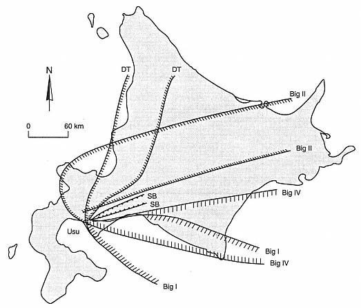
Fig. 5.36
Map of the distribution of tephra from Usu Volcano during the August 1977 eruptions indicates
the extent of measured ash falls from several major episodes of
activity called the Big I, Big II, Big IV, DT, and SB.
(Adapted from Katsui et al ., 1978.)
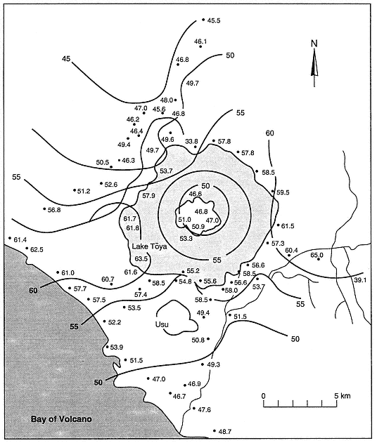
Fig. 5.37
Regional Bouguer gravity near Usu, showing the anomaly associated with the Toya caldera. Gravity
contours and measured gravities are given in milligals.
(Adapted from Yokoyama, 1964.)
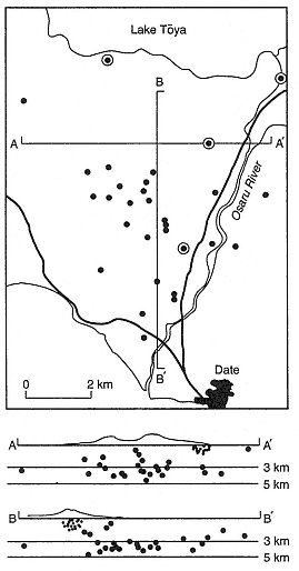
Fig. 5.38
Distribution of seismic hypocenters of A-type
(circled dots) and C-type (small dots) earthquakes
in plan view and along cross sections A-A'
and B-B'. Minakami et al . (1951) related the
clusters of shallow C-type hypocenters just
under the summit of Usu (at the intersection of
the cross sections) and on its eastern flank
to magma movement in a
conduit below growing domes.
(Adapted from Minakami et al ., 1951.)
the caldera is limited by the thick cover of pyroclastic debris from these late stage eruptions. Steam found in well 7 (see Fig. 5.41) was encountered at depths and in lithology that coincide with those of the tuff ring under Terre Blanche, which is exposed on its northeastern side. The steam field underlying Sulphur Springs is thought to have developed in the fractured lavas and breccias of precaldera andesites.
Geophysical Properties
Electrical surveys of the Qualibou caldera have been successful in identifying major faults and general structural features at depth that were predicted by geological cross sections. Greenwood and Lee (1976) completed dipole-dipole resistivity profiles with penetration to 700 m that indicated surface anomalies of conductive rock along linear features corresponding to faults. Ander (1984) extended these data to nearly 2.5 km below Sulphur Springs. Apparent resistivities plotted as a pseudosection in Fig. 5.43 show a resistivity high that corresponds to dacite lavas below the Belfond dome and resistivity lows that are thought to represent conductive geothermal brines along the northern and southern caldera rim faults as well as a deep brine reservoir beneath Sulphur Springs. The higher resistivity zone at an intermediate depth below Sulphur Springs corresponds to depths where wells intersected steam-producing strata; this anomaly is likely produced by dry steam, which is poorly conductive. Gandino et al . (1985) also present gravity data that apparently delineate a positive gravity anomaly in the caldera structure—the result of a relatively dense caldera fill; their audio-magnetotelluric data indicate deep electrical discontinuities related to major faults.
Hydrogeochemistry
Geochemical studies of this area have been performed by Bath (1976; 1977), Aquater (1982), and Goff and Vuataz (1984). Consideration of new data and previous studies led
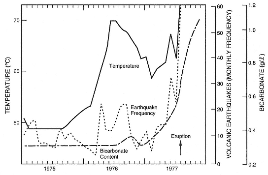
Fig. 5.39
Plot of seismic frequency, hot-spring temperature, and bicarbonate content for the
period 1975 through 1977 at Usu volcano. These three indicators rose
sharply in months preceding the 1977 eruptions.
(Adapted from Katsui et al ., 1981.)
Goff and Vuataz to conclude that a geothermal reservoir underling the Sulphur Springs area consists of an upper-steam condensate zone, an intermediate depth, two-phase zone, and a lower brine zone. Sulphur Springs display chemical compositions (Table 5.5) very characteristic of acid-sulfate systems in which mixtures of steam and other gases condense in the near-surface environment and oxidation of H2 S and H2 SO4 leads to acidic conditions. The springs have relatively low pH, high SO4 , and a low Cl content; divalent and trivalent cations (Ca, Mg, Al, and Fe) dominate Na + K, and most trace elements other than B are relatively scarce. Bath's (1977) brine analyses of well 4 (see Fig. 5.41) show considerable variability because of wet and dry cycling of the flow from the well, which indicates variable steam loss from the brines sampled. Goff and Vuataz (1984) noted that this brine is extremely unusual because the Ca content is twice that of Na by weight and it is very rich in B.
Although drilling encountered temperatures >220°C at depths of 700 m (Williamson, 1979), oxygen isotope composition, gas geothermometry, steam enthalpy, and B abundances indicate brine reservoir temperatures are near 280°C. Figure 5.44 (Goff and Vuataz, 1984) shows a model of the geothermal system beneath the Sulphur Springs area in which geothermal upflow could occur beneath Sulphur Springs and possibly below Belfond—the areas of most recent silicic dome eruptions. Lateral outflow occurs near the surface in the condensation zone, but there is also a strong possibility that it occurs below the vapor zone, where deep brines flow northward and pool against the north caldera-wall
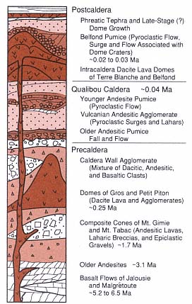
Fig. 5.40
Generalized stratigraphy of Qualibou caldera near
the Terre Blanche dacite dome on St. Lucia. The
stratigraphic section represents a thickness of
~2 km and reflects a general trend from
precaldera mafic andesites and basalts through
intermediate products of caldera-related
eruptions to postcaldera eruptions associated
with silicic dome rock. A vapor-dominated
hydrothermal system is thought to exist in
pumice sections just below the intracaldera
dome lavas, and there is probably a brine
reservoir in the fractured caldera-
fill and precaldera rocks below.
faults. The brine composition indicates it originated from sea water that reacted with basaltic rocks in the subsurface and was subsequently replaced by meteoric water.
Volcanological Interpretations
Young volcanism that filled the Qualibou caldera took the form of dacitic lava out-pourings, which built the Terre Blanche and Belfond domes. This volcanism indicates a magmatic heat source of sufficient size and youth to retain magmatic temperatures at depths of several kilometers or more. Extensive evidence of phreatomagmatic eruptions that postdate the domes is recorded by numerous explosion craters and tephra blankets. Because fragments of the deep basaltic strata exist in the phreatomagmatic tephra and the geochemistry of the brine points to seawater/basalt chemical interactions, it appears possible that a geothermal reservoir formed after dacitic magma intruded into the lower part of the volcanic stratigraphy below the Qualibou caldera (Fig. 5.45). Intersections of caldera ring faults and through-going regional faults have provided fracture permeability along which deep brines have risen. The steam reservoir may exist in still porous and permeable tephra layers and in the caldera fill and precaldera breccias.
Fig. 5.41
Geologic map of the Qualibou caldera on St. Lucia, showing the major silicic dome complexes of Terre
Blanche and Belfond that were erupted after caldera collapse. Exploratory geothermal drilling (Wells 1
through 7) has concentrated on a regional northwest-southeast-trending fault zone that runs between
these two domes. Note the alignment of two large phreatic craters along this fault zone and those along
the ring fracture that extends through the Belfond dome. The depth to precaldera basaltic rocks in
well 2 is at least several hundred meters less than in nearby well 1, which suggests the location of
a western caldera ring fault that exposes precaldera Piton-type dacites.
(Adapted from Wohletz et al ., 1986.)
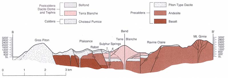
Fig. 5.42
Cross sections along B—B' (see Fig. 5.41) under Terre Blanche dome. Stratifications illustrated at the base of the Terre Blanche
dome denote the pumice-rich tuff ring strata that was erupted before the extrusion of dacite lava. Formation permeability in
these tuffs has allowed a vapor-dominated reservoir to develop. This reservoir is connected by fractures to a deeper brine
zone in the Choiseul Pumice and precaldera andesites below. Geothermal wells 7 and 4 (see Fig. 5.41) intersected these units.
(Adapted from Wohletz et al ., 1986.)
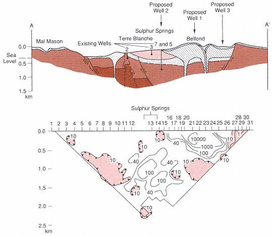
Fig. 5.43
Geophysical resistivity pseudosection along cross section A–A' (see Fig. 5.41) running west of
Terre Blanche and under the Belfond dome. The apparent resistivity high (W-m) under the Belfond
dome represents relatively unfractured dacite lavas, whereas the closed contours of resistivity
lows beneath the north and south caldera margins and below Sulphur Springs are thought to reflect
brine reservoirs. Intermediate resistivity contours below Sulphur Springs at a depth of H1 km probably
indicate the poor conductivity of dry steam. Three exploratory wells were proposed on the basis of
the location of resistivity lows, the geology, and geochemical indicators.
Proposed well 2 produced steam (~300°C) at a depth of ~1400 m.
(Adapted from Wohletz et al ., 1986.)
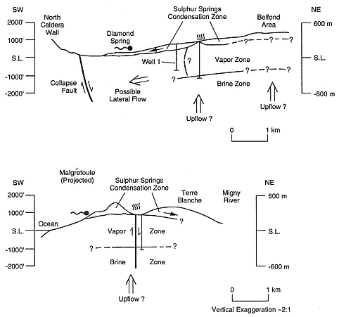
Fig. 5.44
The hydrogeochemical model of the Terre Blanche-Sulphur Springs area shows a vapor
zone over a brine zone as well as upflow under Sulphur Springs and Belfond. The
condensation of steam and mixing with surface aquifers produce later flow toward
the northern caldera margin, which feeds Diamond Spring.
(Adapted from Wohletz et al ., 1986.)
| ||||||||||||||||||||||||||||||||||||||||||||||||||||||||||||||||||||||||||||||||||||||||||||||||||||||||||||||||||||||||||||||||||||||||||||||||||||||||||||||||||||||||
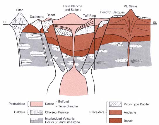
Fig. 5.45
A schematic geological model cross section of the Qualibou caldera from west to east shows (with
some vertical exaggeration) how the dacitic domes have filled in the caldera above the Choiseul
Pumice, which was erupted during caldera collapse. Strong evidence for the caldera structure is
provided by the precaldera basalt that is exposed at the surface near the Piton as well as at many
other locations in southern St. Lucia but is found at depths >1 km in geothermal wells inside
the caldera. The magma chamber is shown as two bodies; the outer one is andesitic and
the source of the precaldera and caldera intermediate rocks, whereas the inner body is
dacitic and represents magmatic resurgence that caused eruption of the dacite domes.
The hypothetical depth of these chambers (~4 km) is drawn from measured geothermal gradients.