Hydrogeochemistry
The first hot spring produced at Usu after the 1910 activity had a temperature of 42°C, but wells drilled later show higher water temperatures, which increase from near the lake to the explosion crater zone where water temperature is 85°C and the Cl- content is 4.261 g/l (Ishikawa, 1970). Fukutomi (1960) recognized two types of hot springs: Type I, found near Meji-Shinzan, has Cl > SO4 > HCO3 and Type II, at greater distance from the young cryptodome, has SO4 > HCO3 > Cl. The major cationic components of each are very similar; that is, Na >> Ca > Mg. Because the water level in the explosion craters is nearly the same as that of Lake Toya, Nakamura (1962) suggested that the hot-springs water originated from the lake and was heated by the cryptodome Meiji-Shinzan. Definite changes in the temperature and chemistry of hot springs were documented before the most recent activity at Usu, and these changes apparently coincide with the monthly frequency of volcanic earthquakes (Fig. 5.39).
Differences in tephra chemistries noted in the eruptions from 1977 to 1978 are also geochemically significant and useful (Kondo et al ., 1979). Pumices from the first-stage magmatic eruptions are grayish-brown in color (SiO2 = 53.91 to 57.55 wt%), weakly alkaline, and rich in water-soluble Ca2+ and Na+ , but poor in water-soluble Cl- and

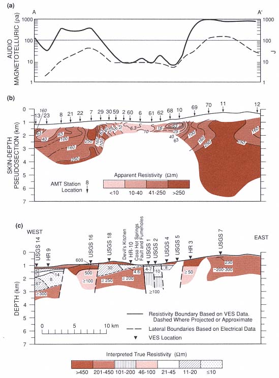
Fig. 5.31
East-west electrical cross sections from Rose Valley across Devil's Kitchen, Coso Hot Springs,
and Coso Basin (see Fig. 5.20). (a) Audiomagnetotelluric (AMT) at 7.5 MHz (heavy line) and Telluric J
(dashed line). (b) Pseudosection skin depths and apparent resistivities from AMT soundings, whose
locations are shown by numbered arrows. (c) Interpreted depths and true resistivities from
Schlumberger vertical electrical soundings, whose locations are shown as HR (Furgeson, 1973)
and USGS (Jackson and O'Donnell, 1980). A section of conductive alluvial deposits occurs in
Rose Valley (west side) and Coso Basin. A secondary resistivity low, occurring in the geothermal
area between Devil's Kitchen and Coso Hot Springs, is caused by a shallow conductive zone that is
interpreted as hydrothermally altered basement rocks containing saline geothermal water.
(Adapted from Jackson and O'Donnell, 1980.)
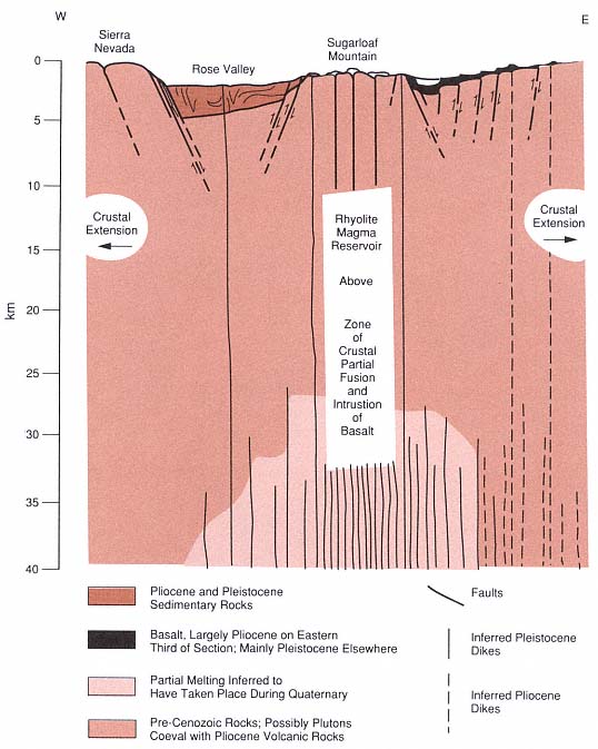
Fig. 5.32
Schematic east-west cross section of the Coso Range through Sugarloaf Mountain. The horizontal
scale is equal to the vertical scale, and there is some surface topography exaggeration. This section
summarizes the geological and geophysical interpretations for the origin of high heat flow from a
rhyolite magma chamber under a horst of crystalline basement rocks on which rhyolite domes have
been extruded. This interpretation emphasizes the fact that the geothermal heat emanates not from
the young domes themselves, but from the postulated underlying magma chamber.
(Adapted from Duffield et al ., 1980.)
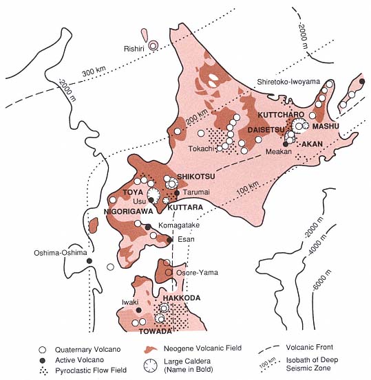
Fig. 5.33
Volcanoes of Hokkaido, showing the Toya caldera and Usu volcano in the southcentral
portion of the island just west of the volcanic front.
(Adapted from Katsui et al ., 1981.)
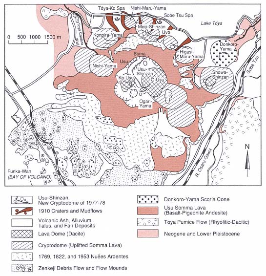
Fig. 5.34
Geologic map of Usu, located on the southern margin of the Toya caldera, which is occupied by Lake
Toya. Usu is a collapsed composite volcano with a small summit caldera that is filled by several dacitic
domes and flanked by the Showa-Shinzan dome and cryptodome. The dome eruptions of Ko-Usu,
O-Usu, and Showa-Shinzan, as well as 7 other cryptodomes of Usu, occurred in historic times.
(Adapted from Katsui et al ., 1981.)
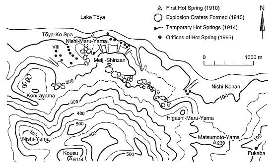
Fig. 5.35
Map of phreatic explosion craters formed during the 1910 activity at the base of Usu volcano.
The Toya hot springs, formed in 1962, became major geothermal direct-use features. This map was
drawn before the eruption of Showa-Shinzan volcano just south of Nishi-Kohan.
(Adapted from Ishikawa, 1970.)