Himalayan Subsistence Strategies
The environmental and cultural diversity of the Himalaya and its neighboring ranges has historically supported a diversity of different, adaptive subsistence strategies. At least five broad, traditional subsistence agricultural strategies and several common substrategies can be identified in the central and western Himalaya of Nepal and India alone: settled, mixed farming; swidden agriculture; middle-altitude agropastoralism; high-altitude agropastoralism; and pastoral nomadism (fig. 1).[6] All five have been employed for centuries and continue to be followed today.[7] Today middle- and high-altitude agropastoralism, both of which are based on mixed mountain farming and livestock herding with transhumance, are by far the most widespread adaptive strategies in the mountain regions of Nepal. Settled mixed farming is becoming more common, in part perhaps as a result of agricultural intensification following increasing population density (Boserup 1965), but also as a result of the commercialization of agriculture in response to changes in transportation (especially the expansion of road networks) and the increasing incorporation of formerly more remote areas into a developing national market economy.[8] Historically integral swidden cultivation based on forest fallow rotations was important across large areas of the country and in much of the temperate and subtropical regions remained so into the nineteenth century.[9] Supplementary swidden cultivation continues to
be carried out in a few regions in central and eastern Nepal today despite government efforts to halt it out of concern for forest conditions. True pastoral nomadism, in the sense of an economy entirely based on pastoralism with no crop cultivation whatsoever, is extremely rare in the Himalaya today and is only followed by a very few groups in the western regions of Uttar Pradesh, Himachal Pradesh, and Kashmir.[10]
All of these except for the settled agricultural strategy share an emphasis on directly using resources across a range of altitudes. Although settlement patterns, crop and livestock emphases, and annual rhythms of movement up and down slopes and mountain valleys vary between the different strategies, all of these strategies except settled, mixed farming use seasonal transhumance, movement of livestock, and/or agricultural fields at multiple elevations to exploit land-use opportunities in different microenvironmental regions of the mountains. Trade is also an important mechanism used by peoples of all five patterns to gain goods from other altitudinal and microenvironmental areas of the mountains as well as from regions beyond the mountains.[11]
Middle- and high-altitude agropastoralism vary in settlement emphasis and seasonal altitudinal use. In Nepal the distinguishing characteristic of the two is that middle-altitude agropastoralism is centered on life in main villages situated below 3,000 meters, whereas people following the high-altitude strategy have villages above 3,000 meters. These two strategies differ, however, not only in their emphasis on different types of microenvironmental regions but also in their basic characteristics of crop and livestock production. Groups following the middle-altitude strategy base their crop production below 2,500 meters in country that supports the cultivation of rice, wheat, maize, and millet as staple crops and where year-round crop growing is possible. Their pastoralism tends to revolve around cattle, water buffalo, sheep, and goats that provide a critical source of manure as well as other useful products and that are supported by considerable use of crop residue and forest fodder as well as by seasonal altitudinal shifts of grazing areas, which in some cases include major long-distance shifts of residence to summer alpine pastures. Groups following the high-altitude agropastoral strategy base their agricultural production on sites between 3,000 and 4,500 meters in altitude, generally in inner valleys, partial rain-shadow valleys of the Great Himalaya, and trans-Himalayan valleys that are shielded from the full force of the southwest monsoon. Crops are grown only in the summer at these altitudes and the crop repertoire consists primarily of barley, buckwheat, and tubers. High-altitude pastoralism is based on transhumant herding of yak, cattle-yak crossbreeds, sheep, and goats. These two different altitudinal strategies are complementary. Many groups fol-
lowing the high-altitude pattern carry out trade to obtain grain from middle-altitude groups, offering high-altitude resources such as Tibetan salt and wool in exchange. There is some seasonal overlap in altitudinal use as well. Both strategies make use of seasonal movement between different altitudinal microenvironmental zones. High-altitude groups herd sheep and goats in lower-altitude agricultural areas in winter, in the process also providing valued manure to middle-altitude farmers' fields. Many middle-altitude groups make use of high-altitude pastures for summer herding.
Middle-altitude agropastoralism was apparently long characteristic principally of Hindu Pahari hill-caste villagers in western Nepal and adjacent western India, whose cultural origins and characteristics are closely related to the people of the Ganges plain of India. High-altitude agropastoralism, by contrast, has been practiced almost exclusively by the Buddhist peoples who live on the frontier between India and Tibet and who, as discussed earlier, in many aspects of culture and lifestyle strongly resemble their Tibetan cousins. Many of the peoples of central and eastern Nepal were long distinct from both groups in land use. Gurungs, Tamangs, Rais, and Limbus, for example, were all formerly integral swidden cultivators who relied on rotational systems of shifting agriculture with long forest or bush fallows.[12] Since the late eighteenth century, however, all of these peoples have adopted the distinctive style of transhumance and terrace agriculture of the middle-altitude agropastoral pattern, either abandoning swidden cultivation altogether or employing it only as a supplementary source of food production.[13] In some regions of mountain Nepal, particularly in lower-altitude areas, some Pahari, Tamang, and Magar villagers and communities are now abandoning the seasonal transhumance of the middle-altitude agropastoral strategy for a settled agropastoralism with year-round residence in a single village. In some areas situated near urban settlements and roads this is often associated with new patterns of crop and dairy production developed in response to new market opportunities.[14] Many peoples following the high-altitude agropastoral pattern have also shifted their adaptive strategies into less mobile patterns of pastoralism and trade during the past thirty years. These ongoing changes in lifestyle and land use highlight the need to bring to the analysis of adaptive land-use strategies not only consideration of the environmental setting and role of adaptation to environment and environmental change but also an awareness of the historical context of cultural, social, demographic, technological, and political economic changes and the ways in which these have influenced both household economic decisions and the evolution of cultural patterns of subsistence and adaptation.
Middle-Altitude Mountain Agropastoralism
The middle-altitude agropastoral strategy combines transhumant tending of cattle, water buffalo, sheep and goats with permanent agriculture that is often carried out at multialtitudinal sites. The main focus of crop production is found in the main villages that tend to be located between 1,000 and 2,500 meters. Here terraces are carefully maintained for the cultivation of rice, maize, millet, buckwheat, mustard, vegetables, and winter wheat. Much effort is put into irrigating fields for rice production, and farmers are familiar with techniques of manuring, intercropping, double and relay cropping, and crop rotation. Surrounding forest and woodland areas supply grazing, fodder, and forest-floor litter for fertilizer as well as furnishing fuel wood and lumber. In summer those households that own substantial numbers of cattle and water buffalo often take them up to the rich pastures between 2,500 and 3,000 meters (this is sometimes handled by a single household member or hired herder rather than by the entire family) and sheep and goats may be taken as high as 5,000 meters (again often by specialists). During these weeks herders may live in simple, movable, bamboo shelters, as is common in Nepal, or more substantial herding huts such as are common in the Indian Himalaya west of Nepal (Pant 1935; Berreman 1963a ). Summer herding bases sometimes provide a secondary crop-production site for the cultivation of potatoes and hardy grains such as buckwheat, wheat, and barley. In autumn livestock are led down to the main villages where they graze on field stubble and leave behind manure for the next round of field preparation. In winter the herds may be taken still farther down the valley, where herders again base in temporary shelters or herding huts.[15]
Middle-altitude agropastoral peoples often also participate in complex regional interaltitudinal and trans-Himalayan trade networks. This trade brings the people of the lower-altitude regions salt, wool, seed potatoes, and other valued products from the high valleys and Tibet in exchange for agricultural surpluses grown in the midlands. Mid-altitude-grown grains, especially rice, maize, wheat, and millet, are traded to higher-altitude regions along with some meat, dairy products, and fruits and vegetables. Much of this trade is carried out by high-altitude people who journey down valley in winter and who may make trans-Himalayan spring and autumn trade trips to Tibet. Some middle-altitude groups, however, transport their own agricultural surpluses into higher regions during the late autumn and winter and some middle-altitude farmers also trade agricultural products they have obtained from other middle-and low-altitude areas.
Figures 2 and 3 illustrate the geographic and altitudinal seasonal land-
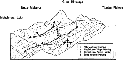
Figure 2.
Middle-Altitude Agropastoralism, Geographic Patterns (Base drawing
adapted from Metz 1989)
use patterns associated with the middle-altitude mountain agropastoral strategy. In them I distinguish four different patterns of seasonal altitudinal and geographical land-use patterns. Two are relatively compressed in both altitudinal and geographical land use, making use of the resources of a single slope. Two are extended in altitudinal and geographical land use, making fuller use of the resources not only of variations in slope but also of longer-distance up and down valley movements. The first of the slope-based patterns is a village-based, relatively settled way of life such as is practiced particularly by groups living in the lower-altitude regions of the Nepal midlands. Here the entire focus is on crop production in the main village with herding and fodder collection from slope areas within easy reach of the settlement. All the other subsistence patterns require seasonal shifts of residence by at least some family members. The second pattern makes use of microenvironmental variation on a single slope, but the distances and relief involved make it necessary for herders to base seasonally in herding huts (goths ) a day or two away from the main village. Cattle, water buffalo, sheep and goats may thus be taken on a limited-distance transhumant migration that may nonetheless cover several thousand meters of altitudinal variation. This movement of only a few kilometers takes them to summer pasture high on the ridge in the temperate forest or even subalpine zone and may also take them to winter pastures below the village in subtropical reaches of the gorge. The third pattern is a longer-distance transhumance in which flocks of sheep and goats and possibly also herds of cattle, crossbreeds, and even water buffalo are taken up valley to summer pastures in the Great Himalaya above 3000 meters. The fourth pattern that traverses
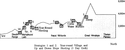
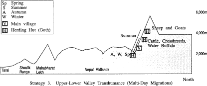
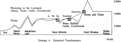
Figure 3
Middle-Altitude Agropastoralism, Altitudinal Patterns
the ranges adds to the third pattern a longer-distance winter move as well, one which takes herders and their sheep, goat, and cattle across the Mahabharat Lekh and out of the midlands into the valleys north of the Siwalik range or even beyond the Siwalik range to its southern alluvial slopes and the Tarai.
In the Dudh Kosi valley and adjacent areas variations of middle-altitude agropastoralism are practiced by Rais, Gurungs, Magars, and several Sherpa groups including the Pharak and Shorung Sherpas. Some of these Sherpa groups have adopted land-use practices that they may have adapted from those of their non-Sherpa neighbors and which from the standpoint of Khumbu Sherpas are quite "un-Sherpa." Some Sherpa families in the Dudh Kosi region, as in the Arun watershed, for example, raise water buffalo and practice swidden cultivation. And in the Arun region some Sherpas even raise pigs and cultivate irrigated rice.
Within the range of microenvironments found in the Nepal midlands and the Great Himalaya between 1,000 and 3,000 meters a great diversity of production systems could be described through which middle-altitude agropastoralists use the resources of particular sites. In the 1,500-2,500-meter altitudinal range in which most of the main villages are located these systems include several different types of production based on rain-fed permanent crops with and without small-scale keeping of cattle, water buffalo, sheep and goats such as year-round cultivation, summer-only cultivation, different types of annual and multiyear crop rotations and fallowing practices, different types of intercropping and relay cropping, food and fodder crops, subsistence and commercial crops. There are also systems based on irrigated agriculture (including rice only and rice followed by winter-irrigated or nonirrigated crops), again with and without associated livestock raising, as well as a number of different types of woodland, forest, grassland use and management. These could be further differentiated on the basis of variations in the use of agricultural inputs (seed, fertilizer, and labor especially), by the social and cultural arrangements influencing crop production, and orientation towards subsistence or commercial production. While this approach would offer valuable insights into land-use techniques and institutions, a fuller understanding of local land use would require both attention to differentiation in wealth, power and other factors that influence household and community resource-use options and decisions and the investigation of the strategies by which particular families, economic classes, communities, and ethnic groups combine sets of these microenvironmentally based production systems into household and regional economies.
Different peoples within the middle-altitude region employ slightly different production systems in very similar microenvironmental sites, and individual ethnic groups make use of more than one system even in similar sites. Crop decisions and rotations, field-fertilization practices, grazing patterns, and other aspects of production systems may vary. Such differences may reflect cultural perceptions (including crop and livestock preferences and religious prohibitions), social arrangements (especially land tenure and communal resource-management institu-
tions), economic differentiation, and political power. There is accordingly no simple equation between given microenvironments and the production systems used in them, although environmental conditions (including altitude, slope, aspect, and the amount, type, timing, and intensity of precipitation) may broadly influence the range of what is and is not rewarding in terms of high yield and low risk.
High-Altitude Mountain Agropastoralism
Above 3,000 meters life is different for the high-altitude-dwelling peoples who make the high valleys of the Great Himalaya and trans-Himalaya their home.[16] At these altitudes crops can only be produced during the summer and generally there is not time enough in the short growing season to cultivate more than a single crop per year of a small number of plants fit for high altitude. The cool temperatures and the risks of late spring, early autumn, and even summer frosts restrict the range of staple crops to barley, buckwheat, wheat, and tubers. Rice, maize, and millet cannot be cultivated and at higher altitudes even wheat production is not possible. Pastoralism is similarly limited in options. The climate is too difficult for water buffalo and cattle may be kept year round at such heights only if much effort is made to stable them and provide them with fodder through the winter months. But yak, yak-cattle crossbreeds, sheep and goats all thrive. Figures 4 and 5 show the geographical and altitudinal land-use patterns associated with variations of the high-altitude mountain agropastoral strategy. As with the middle-altitude agropastoral strategy both extended and compressed strategies are depicted. Extended strategies make greater use of seasonal transhumance, either across the Himalaya to Tibet for winter herding of yak and sheep, down-valley winter herding of sheep, goats, and cattle in the midlands or even the Tarai, or a combination of both of these. The compressed pattern relies on year-round use of the resources of the Great Himalaya alone.
For the past century, and very likely for long before that, peoples following high-altitude agropastoral strategies have usually relied on trade to supplement their crop production. Trade for lower-altitude-grown grains has been particularly important. Until the 1960s many families devoted much of their winter to trading trips to the south in order to barter Tibetan salt and other goods for grain and take advantage of the warmer weather, the readily available food, and the good grazing. Sheep and goats were often taken on these winter journeys as pack animals, whereas families who kept yak left them with herding specialists in the high valleys or sent them across the mountains to Tibet, where the grazing is often better in winter than on the south side of the Himalayan crest
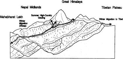
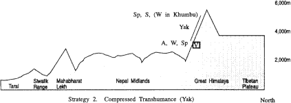
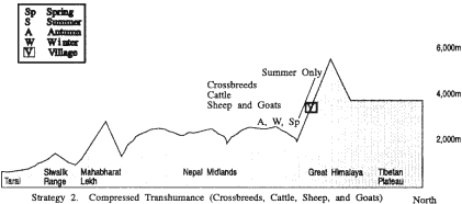
Figure 4.
High-Altitude Agropastoralism, Geographic Patterns (Base drawing
adapted from Metz 1989)
since there is less snow and yak can find abundant grazing on the vast pastures. This way of life, however, is today no longer followed by many Bhotia groups. Political and economic changes in Tibet following the onset of Chinese administration after 1959 have greatly affected trade conditions for Bhotias, as did the 1962 war between China and India and its diplomatic aftermath. Some groups of Bhotias have been unable to continue trans-Himalayan trade on the old scale or to winter stock in Tibet. This has led to major changes in life for Bhotia peoples (see, for example, Fürer-Haimendorf 1975; Rauber 1982). Some have abandoned their former subsistence strategies and migration from the high country and other high-altitude peoples have developed new types of trade or become involved in the tourism industry.
Transhumance is an important feature of the high-altitude agropastoral strategy. After the crops are planted and well established in the main villages families follow the good grass into the upper valleys. Yak and sheep may be herded in mid- and late summer as high as 6,000 meters. Herders usually live in tents, often the black yak-hair tents familiar also in Tibet, moving through a series of different camps in a long-established routine modified to meet the pasture and weather conditions of the particular year. Sometimes additional fields are also cultivated in the summer herding settlements where fine crops of potatoes and barley can be grown even as high as 4,300 meters. Families who continue to trade with Tibet dovetail the demands of the agricultural cycle with one or more trips across the border during the period between spring and late autumn to obtain salt, borax, wool, and other goods for their winter trading in the south.
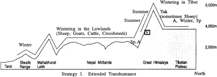
Figure 5.
High-Altitude Agropastoralism, Altitudinal Patterns
Only a few Sherpa groups follow a high-altitude mountain agropastoral strategy, the best known of which are the Sherpas of Khumbu and Rolwaling. The narrow valley of Rolwaling, seven kilometers in length and never more than one kilometer wide, is comparable in altitude to Khumbu. The main village, Beding, is situated at 3,600 meters. Fewer than fifty households inhabit the valley and they prac-
tice a mixed agropastoralism emphasizing transhumant yak herding and multialtitudinal crop production of potatoes and barley. Potatoes and barley are grown as high as the settlement of Na at 4,100 meters. Yak are herded in the summer to above 5,000 meters (Sacherer 1981:157-158). Khumbu Sherpa subsistence strategies are discussed later in this chapter.
Altitudinal Production Zones
Land use at the scale of an entire Himalayan valley such as that of the Dudh Kosi becomes exceedingly complex to analyze at the level of production systems. The range of altitudinal gradients and micro-environmental variation, the diversity of adaptive strategies, and the high level of cultural diversity (in the Dudh Kosi case four different Sherpa groups, at least two Rai groups, as well as Magars and Gurungs) make for a wealth of production systems. This diversity can be simplified at the regional scale for a general overview, however, by considering altitudinal production zones. These constitute broad categories of land use encompassing a number of different, discrete production systems. They narrow the focus of microenvironmental concern to a few broad altitudinal bands identified according to basic regional altitudinal variation in land-use patterns. From this perspective six altitudinal production zones can be discussed in the Dudh Kosi valley (fig. 6) ranging from irrigated and nonirrigated year-round crop production to high-pasture pastoralism. Table 2 shows the current upper altitudinal limits of the staple crops in the valley. Note that Khumbu is situated too high in altitude for the harvest of more than a single summer crop per year and is just out of the current altitudinal range of cultivation of such important Dudh Kosi valley crops as maize and wheat.[17]
Sherpas, Rais, and Gurungs each make use of several zones through middle- and high-altitude agropastoral strategies and in each practice one or more different production systems based on different institutional, cultural, and technical arrangements for raising various types of crops and livestock and exploiting altitudinally related natural resources such as forests, woodlands, and temperate, subalpine, and alpine grasslands and tundra. Within a given altitudinal production zone the choice of cultigens and domestic animals, the scale at which they are raised, and the techniques employed may vary with cultural preferences, religious beliefs, political economy, household status and wealth, and historical processes and events such as the diffusion of terracing techniques, the introduction of new crop varieties, changing trade patterns, and changes in local affluence.[18]
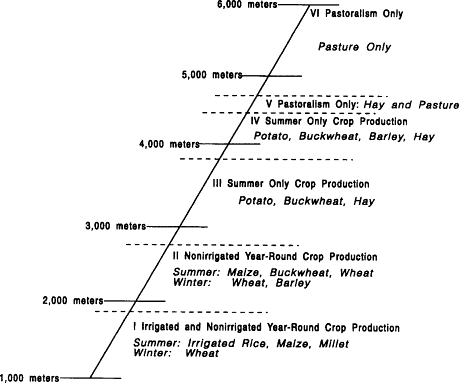
Figure 6.
Dudh Kosi Valley Altitudinal Crop-Production Systems
Table 2 Current Upper Altitudinal Limits of Staple Crops in the Dudh Kosi Valley | ||
Potato | 4,700m | (Tarnak) |
Barley (ua ) | 4,300m | (Dingboche) |
Buckwheat | 4,000m | (Pangboche) |
Barley (jou ) | 2,800m | (Jorsale) |
Wheat | 2,800m | (Jorsale) |
Maize | 2,800m | (Jorsale) |
Millet | 2,000-2,200m | (Kharikhola) |
Rice | 2,000-2,200m | (Bupsa) |
Regional Linkages
Himalayan valleys are typically the homes of a number of different peoples and groups each occupying its own territory and pursuing its own characteristic subsistence strategy or strategies and set of land-use
production systems. These different groups are seldom independent socioeconomic islands and even where there has not been a history of political conflict (conquest, raids, tribute), migration, pilgrimage, or intermarriage there is usually a complex interaction based on trade. It is common also for the dynamics of subsistence strategies themselves to create other types of more direct resource-use interaction. Both the middle-altitude and high-altitude strategies characteristically employ tactics of multialtitudinal land use and seasonal movement between several settlement sites. There is often some overlap in the microenvironmental areas exploited, especially for pastoral patterns. Both middle- and high-altitude agropastoralists value the grazing resources found in the high summer pastures and the lower valley forests, grasslands, and fallowed fields. This sometimes leads to different groups, often of different ethnicities, seasonally making use of the same areas or of crossing other groups' territories en route to their own secondary settlement and grazing areas. To coordinate this multicultural use of particular areas arrangements are made that include joint resource management, user or transit fees, defined common property resource-use boundaries, sequential resource-use arrangements, and other examples of temporal and territorial resource partitioning. In some cases differences in resource-use goals and land-use production systems make it possible to develop complementary multiethnic resource use. A given high-altitude place may be valued as a summer herding area for the sheep and goats of a middle-altitude agropastoral group, for example, and also be an agricultural area for a high-altitude agropastoral group that may value the additional manure provided by the outsiders' sheep. Such complementary resource use is even more common in the altitudinal reaches where middle-altitude main villages are situated. Here middle-altitude households may offer cash and other incentives and compete with each other to obtain better fertilization for their winter fallow fields by having them grazed by the flocks of high-altitude herders who have come down valley for winter grazing. In other cases, however, these same resource activities are seen to compete with local herders' access to pastures, and herding families demand compliance with local grazing restrictions and the payment of grazing fees, or even ban outside herds altogether.
The subsistence strategies and regional resource-use patterns of middle- and high-altitude agropastoralists in the Dudh Kosi valley have historically resulted in a complex pattern of regional trade, seasonal movement, overlapping land use, and resource partitioning and management within a broad general altitudinal differentiation of land use and associated production systems. Rais and Gurungs from the lower reaches of the watershed have taken sheep and goats up into the high pastures, often to their own areas (some of which they retain through claims predating the in-migration of Sherpas), but in other cases to Sherpa-
controlled regions where they have had to follow local grazing regulations and sometimes pay fees. Sherpas from both Khumbu and Pharak formerly took stock (at least on a small scale) into middle-altitude Rai areas, in some cases paying fees for the privilege. In other areas Sherpas have had to pay summer high-altitude grazing fees to Rais. High-altitude Khumbu Sherpas have engaged in trade with both middle-altitude Sherpas and Rais as a basic component of their subsistence economy and both middle-altitude Sherpas and Rais have also long traded to Khumbu. The scale, nature, and geographical extent of this trade, however, has varied enormously over the past century with considerable impact on local subsistence strategies.