Geologic Setting
The Coso range is a horst block immediately east of the Sierra Nevada range in eastern California. It is covered by a veneer of ~400 km2 of mostly lava flows and domes of late Cenozoic age. Early geologic exploration (Ross and Yates, 1943; Dupuy, 1948) identified mercury, which has been mined in fumarolically altered rocks near rhyolite domes; numerous subsequent studies have described pyroclastic and volcaniclastic deposits, the general stratigraphy, potassium-argon ages, and geothermal phenomena. Duffield et al . (1980) documented both the relationship of the volcanic rocks to an underlying granitic basement (Fig. 5.20), which is exposed within the volcanic field and along its margins, and the nature of a late Cenozoic extension, which is marked by north-northeast-trending normal faults that have produced considerable uplift of horst block under the range.
The geothermal system has developed in a Mesozoic basement of dominantly granitic plutons and subordinate mafic plutons and metamorphic rocks associated with the Sierra Nevada composite batholith. Late Tertiary and Quaternary volcanic rocks drape over the basement. Duffield et al . (1980) used potassium-argon and obsidian-rind techniques to determine that ~35 km3 were erupted between 4.0 and 0.04 Ma (Fig. 5.21). These volcanic rocks include 38 separate domes and flows of phenocryst-poor, high-silica rhyolite, most of which are likely younger than 0.3 Ma.
The oldest lavas, alkalic basalt flows, are the most voluminous and widespread of Pliocene volcanic rocks (Fig. 5.22) and were erupted from cinder cones onto a relatively subdued terrain. They occur as notable stepfaulted flows in the eastern portion of the field. These lavas are overlain by Pliocene andesite, dacite, rhyodacite, and rhyolite flows and tuff. Andesite and dacite occur as parts of polygenetic volcanoes in which dacite flows, shallow intrusive masses, and pumice are interlayered with andesite flows and
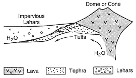
Fig. 5.19
Basin-filling clastic rocks shed from a growing
silicic dome can provide a permeable formation
for a hydrothermal reservoir—especially when
continued down-warping of the basin allows
it to be filled with impervious sediments such
as lahars. These lahars efficiently hide the
geothermal reservoir, which develops at
some distance from the volcano.
cinders. Rhyodacite is found in widespread pumice fall and lava flows, and Pliocene rhyolite forms a nonwelded pumiceous ash flow that is intercalated with sedimentary volcaniclastic rocks of the Coso Formation.
The youngest volcanic rocks are Pleistocene in age and consist of contemporaneous alkalic basalt and high-silica rhyolite (Bacon et al ., 1980). Most basalt vents are marked by partly eroded cinder cones that fed one or more lava flows on the east, south, and west sides of the rhyolite field. Pleistocene rhyolites compose the 38 steep-sided domes as well as some short, thick flows whose surfaces are notably perlitic and pumiceous. Bacon et al . (1981; 1984) inferred that the rhyolite magma (total extruded volume @ 1.6 km3 ) erupted from a chemically stratified magma chamber, which formed when mantle-derived basalts partially melted crustal rocks. Most domes have extrusive volumes of <0.3 km3 and are located within and/or above tephra rings that were formed by the initial explosive phases of dome eruption. The tephra from these dome eruptions have a total volume of ~0.3 km3 and consist of well-bedded obsidian, pumice, and rhyolite clasts and minor amounts of lithic fragments from basement rocks. Accretionary lapilli and impact sags provide evidence that the tephra are in part hydrovolcanic. Tuff rings average about 600 m in diameter, and rim deposits range from several meters to 30 m thick. Most of the rhyolite field is mantled by tephra similar in character to those in the tuff rings. The first production well completed by California Energy is collared within the tuff ring of dome 53 near the Devil's Kitchen fumarolic area (Fig. 5.23). Intensely fractured Mesozoic basement rock encountered by the well can be attributed to several processes, including hydraulic fracturing associated with hydrovolcanic explosions that occurred during the initial eruptions of this dome, thermal stresses exerted by elevated heat flow, and ongoing tectonic movement. Other geothermal wells are being bored in the area around dome 53.
Using the distribution of silicic vents, the volume of extruded magma, gravity and seismic surveys, and heat flow measurements, Bacon et al . (1980) predicted that a silicic magma body ~5 km in diameter and >1 km thick (a total volume of at least 20 to 30 km3 ) underlies the Coso volcanic field at a depth of at least 8 km. It is possible that the silicic magma body may still be partially molten, if one applies the reasoning that the most recent basaltic eruption occurred as late as a few thousand years ago and that such extrusions are evidence that heat was supplied to the magma body from an underlying mafic reservoir. Bacon (1982) indicated that the ages of extrusive rocks (Friedman, 1976), plotted in Fig. 5.21 with respect to cumulative volumes, show a trend that suggests these eruptions will continue in the future.
Figure 5.24 illustrates three sets of faults in the Coso Range (Duffield and Bacon, 1979; Roquemore, 1980) that indicate principally late Cenozoic crustal extension; outward dips of the Coso Formation demonstrate considerable uplift of the range during Pliocene time. A west-northwest-trending set of apparently vertical faults are well developed in the southern and western parts of the range. This fault set is an expression of
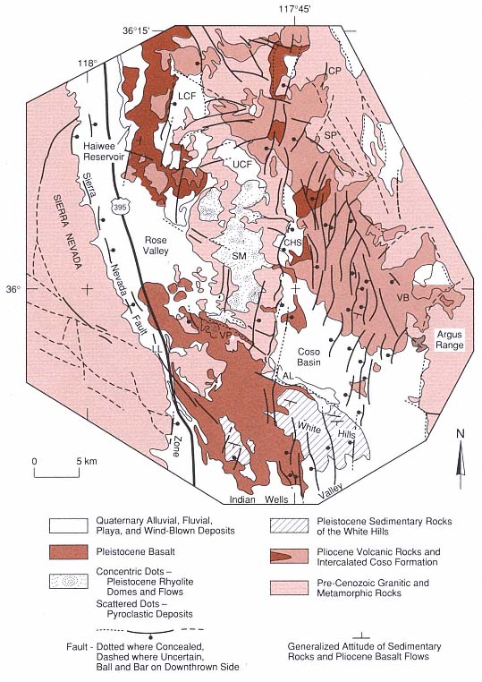
Fig. 5.20
Geologic map of the Coso volcanic field of California, showing distribution of major rock units and
faults. Abbreviated locations: CP = Coso Peak, LCF = Lower Cactus Flat, UCF = Upper Cactus Flat,
SP = Silver Peak, CHS = Coso Hot Springs, SM = Sugarloaf Mountain, VB = Volcano Butte,
VP = Volcano Peak, AL = Airport Lake, and LL = Little Lake.
(Adapted from Duffield et al ., 1980.)
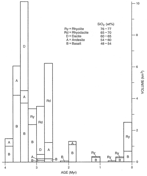
Fig. 5.21
Rock volumes and compositions vs radiometric age for the Coso volcanic field. Volumes were
calculated by using the geological map area and cross-sectional exposures and allowing for
material removed by erosion. Volumes of pyroclastic rocks were converted to dense rock
equivalence by multiplying by 0.5. Exponential thickness decreases with distance were
applied to pyroclastic deposits. In the last 4 Ma, ~35 km3 of lava has been erupted, of
which 31 km3 erupted before 2.5 Ma ago.
(Adapted from Duffield et al ., 1980.)
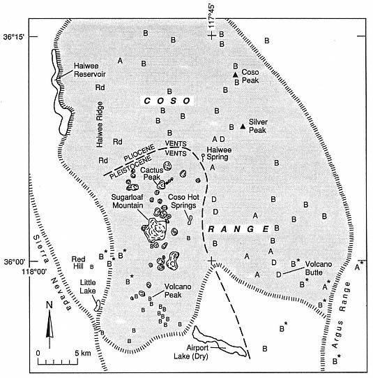
Fig. 5.22
Distribution of eruptive vents in the Coso volcanic field of California. The locations of vents are
shown by letters designating the composition of materials erupted: B = basalt, A = andesite,
D = dacite, and Rd = rhyodacite. Asterisks denote the location of
Late Pliocene and early Pleistocene vents.
(Adapted from Duffield et al ., 1980.)
regional structure and, although these faults do not offset Pleistocene rhyolite, some of the silicic domes are aligned along their strike. The basin and range morphology of the Coso range is developed along north-to northeast-trending normal faults. These faults cut the horst onto which the rhyolites have been erupted and form en echelon sets that are consistent with north-northwest right lateral shear. In Fig. 5.25, information from Bacon et al . (1980) shows that the Quaternary maximum horizontal compression follows this northeast trend. This interpretation arose from consideration of the distribution of domes and application of the stress analysis suggested by Nakamura (1977). Arcuate faults present in the northern and northeastern parts of the field are approximately
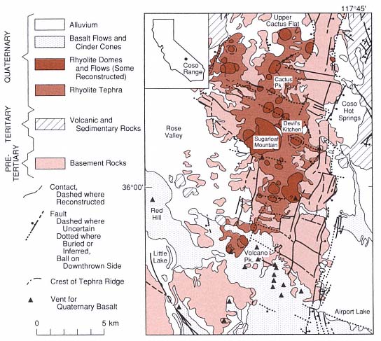
Fig. 5.23
Generalized geological map of the principal geothermal area in the Coso geothermal area. Coso Hot
Springs emanate along major graben-bounding faults, whereas geothermal drilling has focused on
the region around Sugarloaf Mountain rhyolite dome and the Devil's Kitchen fumarolic area. Hulen
(personal communication) reports that drilling in regions around these
vents has encountered intensely fractured basement rock.
(Adapted from Bacon et al ., 1980.)
concentric around the geographic center of the field and dip inward toward this center. This set of faults was originally interpreted as part of a caldera structure (Austin et al ., 1971; Koenig et al ., 1972), and more recently, Roquemore (1980) has attributed their origin to strike-slip movement; however, Duffield (personal communication, 1990) is not convinced by either of these interpretations. The step-faulted terrane in the eastern part of the volcanic field near Airport Lake (see Fig. 5.23) is attributed to downwarping and down-faulting in response to late Cenozoic crustal extension that caused an effective decoupling of that terrane from a block-faulted terrane to the west and south. Figure 5.26 depicts the step-faulted terrane that forms a graben structure and its relationship to the horst on its west side onto which the rhyolite domes have been extruded. An ongoing study by California Energy indicates that new interpretations of structural relationships will be required to fully understand Coso's geothermal system.