Chapter Four
Bhaktapur's Other Order
Introduction
In the later chapters of this book our central concern will be with Bhaktapur's marked symbolism. The city has, of course, another sort of life that must be described and analyzed in its own terms and whose relations to the particular sort of symbolic order we are concerned with are various. This other order is often dealt with as more real in some sense than the "merely" symbolic order—as one or another kind of "infrastructure." It includes spatial and ecological constraints, aspects of production and distribution, demography, and the like. In still other scholarly traditions "social structure" is given the privilege of a more fundamental reality. These privileged realities are set against what we call "marked symbolism," which is often degraded to epiphenomenal or "expressive" or at best to some modestly supplementary status. We will claim more for Bhaktapur's marked symbolism, but we are not reversing the ideology to argue that the other orders are unimportant or secondary. The interrelations of the realm of marked symbolism and other kinds of order (suffused with their own embedded symbolisms) are diverse. We will touch on some of this in the course of this book. For the reasons urged in chapter 2, however, marked symbolism is our centerpiece.
Bhaktapur's other orders thus become peripheral, but hardly trivial. Their presentation, the subject of this and the following two chapters, is relatively summary, and for this chapter heavily indebted to the work of others.
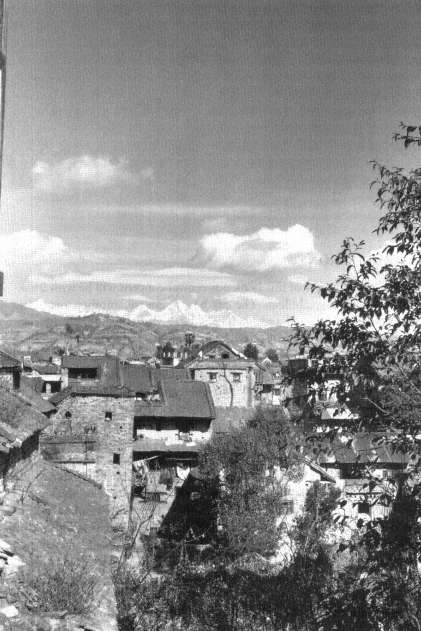
Figure 1.
Bhaktapur, looking north to the Himalayas.
The Physical City
Bhaktapur (see fig. 1) at the time of this study had not, at first sight, changed very much in appearance from nineteenth-century descriptions and aside from a general weathering and decay, probably not much from its appearance at the end of the reign of the Malla kings. Built on the sides and summit of a broad hill rising from the valley floor, the city suddenly appears, clearly demarcated from the extensive farmlands around it. The city is roughly elliptical, about one mile in length and about one-half mile in breadth, with its long axis running from west to east with a slight southwest-northeast rotation. A main road enters the city from the west and meanders along the central axis running parallel to the Hanumante River, which borders Bhaktapur to the south. This road soon becomes the bazaar, a dense conglomeration of small shops that line the street for much of its extent. At intervals the road widens out into various public squares full of temples and shrines as is the case in many Newar settlements. Its inhabitants think of Bhaktapur as consisting of a lower city to the southwest and an upper city to the northeast. The bazaar street has two prominent large squares, Ta:marhi Square in the lower city and Dattatreya in the upper. The main axis is intersected by a number of routes that have bridged the Hanumante and entered the city from the south. It leads finally to a road leaving Bhaktapur to the east, once an important route to Tibet.
To the north of the central axis in the western part of the city is the former Malla Royal center, the Durbar square or Laeku. At its northern side is a prominent gateway covered with golden images of gods, the entrance to a complex of courtyards, shrines, and sanctums—the temple of Taleju, the tutelary goddess of the Malla kings. Adjoining the Taleju temple is the large palace, formerly the seat of the Malla kings of Bhaktapur, now administrative offices for a new polity. Around the Durbar square are the tall, tile roofed houses of many of the Rajopadhyaya Brahmans, once closely associated with the court, as well as houses of descendants of the old court aristocracy.
In various parts of the city there are clearly differentiated neighborhoods. There is the potters' quarter with its potting wheels, its kilns and open spaces for the firing and sun-drying of pots; the dyers' quarters with various brightly colored woolen yarns hanging to dry near the dying vats; farmers' quarters with—depending on the season—rice, wheat, corn, peppers, and other crops being threshed, winnowed, dried. There are neighborhoods of Buddhists, mostly in the northern parts of the
city, surrounding their old monasteries, now centers of Tantric, non-monastic Buddhism. There are other neighborhoods not so clearly marked by external contrasts, but clustered around a central square with its temples or shrines. Toward the borders of the town are generally poorer areas with lower, simpler houses. But among them there are groups of taller, more elaborate houses, those of the butchers whose low status places them toward the periphery of the city, but whose comparatively high earnings have allowed them to build larger houses than their neighbors. To the south of the city, in an area that is said to be outside its boundaries, in squalid small houses, tightly grouped together, live the untouchables.
Along the Hanumante River at a number of places are clusters of shrines and ghats or steps leading down to the river. Here clothes are washed, and here and there are ramps for dipping the feet of a dying man into the river at his last breath. Along the Hanumante River, mostly on the far side, are cremation grounds. There is another river, the Kasan, to the north of Bhaktapur, which joins the Hanumante to the west of the city. This northern river has little to do with the life of the town.[1]
Everywhere there is a bustle of activity, of people coming and going, of processions, of music, of business, of craftsmen working. Scattered here and there are new buildings in modern styles, offices and houses for officials, modern houses for some rich merchants, schools, a hospital, a cinema.
And everywhere are dirt and foul smells, the dust and wear of centuries, the feces of animals and children in the streets, of adults in the fields and at the riverside. There are houses cracked and fallen during the last of the series of earthquakes that regularly trouble the Kathmandu Valley. The fields and streets are full of scavenging emaciated dogs and of large carrion crows. Huge fruit bats hang in some seasons in the trees, and on clear nights jackals howl in the fields outside of the city and occasionally a predatory, hungry leopard snatches off the infant of an unwary farmer in a field bordering on the forest. All this is a reminder that Bhaktapur was and is still a clearing in h yet more ancient world.
Some Demographic Notes
According to the 1971 census report (published by the National Planning Commission of Nepal's Central Bureau of Statistics), Nepal then had a total population of 11,555,983. Of these, 618,911 lived in the
Kathmandu Valley, which was divided into three districts—Lalitpur (Patan), Kathmandu, and Bhaktapur. These districts comprised roughly the three old Newar kingdoms, each with its central city and surrounding secondary towns, villages, and scattered hamlets. Of the three districts, the Bhaktapur district had the smallest population, 110,157, in comparison with Patan's 154,998 and Kathmandu's 353,756.
Within these districts the city of Bhaktapur had a total population of 40,112 people, in comparison with urban Patan's 59,049 and urban Kathmandu's 249,563. The census for Bhaktapur conveniently distinguishes categories of prisoners incarcerated there and of military and police stationed at Bhaktapur, people who represent for the most part an "external" population. Without these two categories (133 prisoners and 918 police and military) Bhaktapur's population consisted of some 39,061 people, living in 6,484 households.
Between 1961 and 1971 the population of Bhaktapur had reportedly grown by 17 percent, somewhat less than the 22.8 percent reported for Nepal as a whole, and the 25 percent reported for Kathmandu. (Kathmandu's population increase is augmented by internal migration within Nepal.) These increases were probably due to recent improvements in public health and nutrition and, perhaps, changes in census techniques. Overall, however, there is no indication that Bhaktapur has increased in population very much since the eighteenth century; that increase is just beginning now.[2] We have noted Kirkpatrick's report for 1793, that he was told that Bhaktapur and its dependencies (approximately equivalent to the present Bhaktapur district) had some 12,000 homes. If we guess that houses had something like the present number of inhabitants, such a figure would not indicate a great increase in the population of Bhaktapur district over the past 200 years. Similarly, Oldfield writes that in the 1850s there were supposed to be about 50,000 inhabitants in Bhaktapur city itself ([1880] 1974, vol. 1, p. 131).
The age structure of the population of Bhaktapur in 1971 was that of a young population—15.3 percent of the population of the city being under five years, and some 47.7 percent of the population under the age of twenty. The figures for sex (for the nonmilitary and prisoner populations) show a slight excess of males over females of 2.5 excess males per hundred males. This sex ratio, when compared to the much larger predominance of males over females in other Nepalese cities, is an index of Bhaktapur's lack of in-migration, which for other cities was mostly male.[3] This lack of in-migration was confirmed by a sample survey by the United Nations Fund for Population Activities done in 1976, which
during a period when there was an immigration into the Kathmandu Valley of about 2,000 people a year, showed a "negative migration" for Bhaktapur where there was no appreciable immigration and a small annual out-migration of some 100 to 150 persons a year, mostly "to seek jobs in Kathmandu" (Acharya and Ansari 1980, 106).
All available indexes suggested that at the time of this study Bhaktapur's population was, and had been for a very long time, quite stable.
Population Density
The most significant demographic aspect of Bhaktapur for the purposes of this study besides its stability is its population density. In a pioneering study of the physical and cultural geography of Nepal, Pradyumna Karan (1960, 51) remarked that:
Few parts of the world are more empty than the snow-covered ranges of northern Nepal; few parts are more crowded than the Kathmandu Valley. . . . In the major areas of concentration the average population densities range from 500 to 700 per square mile, and there are rural densities in a few small areas of more than 800 per square mile. Such density of rural population is hardly approached in Western Europe or North America; it is equaled only in monsoon Asia and in a few small areas of Africa and the Caribbean. Despite the many empty areas, virtually all of Nepal's space is fully used in terms of the number of people it can support with its present technology. . . . The population of Kathmandu's urban area attains a density of 47,783 per square mile, almost twice that of New York City.
Bhaktapur's density is still higher. A survey cited in Acharya and Ansari (1980, 105f.) estimates that when the open spaces are removed the concentration of people in the built-up residential areas of Bhaktapur is 110,334 people per square mile. Most of those open spaces are at the outskirts of the city, and our own estimates of the settled area give a density of some 117,000 people per square mile for the remainder of the city, including its inner open spaces. Such population density is even more striking in that the city has a considerable number of such open spaces and public squares and that, in contrast to modern inner cities, most of its houses consist of five stories or less.
Such figures are astonishing not only in themselves but also because for those familiar with "downtown" areas of New York, London, or Calcutta, Bhaktapur in no way seems crowded . Throughout the entire city space there is an orderly and widely distributed placement of people and of their movements. it is only during certain of the city's annual
festivals when much of the population gathers together at one or another focal point or area that the great mass of population becomes apparent in an unusual concentration that in itself generates some of the meaning of the festival.
Bhaktapur's Demography: Newars And Hindu Newars
We shall present in later chapters other demographic characteristics of the population of Bhaktapur—its ethnic, religious, and social composition and aspects of household size and composition. It is essential to emphasize, however, that less than sixty households among Bhaktapur's more than 6,000 households are, by criteria that we will discuss in the next chapter, not Newars. That is, the city is almost entirely a Newar city. It is, in addition, almost entirely a Hindu Newar city. In the 1971 census 92 percent of the Newar population called themselves "Hindus"; the rest, the remaining 8 percent, identified themselves as "Buddhists." It is this great preponderance of Hindu Newars who are at the center of our treatment of Bhaktapur's symbolic organization. Some individuals in the other groups are, in fact, involved in that organization—in sometimes illuminating ways—but their involvement is peripheral, and they themselves are most centrally related to other centers of community and of identity.
The Hinterland
Bhaktapur district, the area containing the city of Bhaktapur and its surrounding towns, villages, and open lands, with its 110,157 people in 1971, is the most densely populated of the three valley districts. There are some seven settlements (other than Bhaktapur) in the district with more than a thousand population. Six of these ranged between 1,200 and 3,000 people in 1968. One of them, Thimi, had more than ten thousand people (His Majesty's Government, Nepal 1969, 81). The other district settlements are hamlets and small villages. Some of the Newar towns in the various Valley districts have been studied (Barré, Berger, Feveile, and Toffin 1981; Toffin 1977; Müller 1981). What remains still to be done is a study of their past and present relations with the main cities, and the systematic transformations of Newar social and cultural life illuminated by the contrast in size of the central and peripheral communities. The relation of the city of Bhaktapur to
the rest of the district is for reasons given in chapter 2 only minimally considered in this present study.
Relation To The Central Government
In the early 1970s Bhaktapur, like all settlements of more than 10,000 people in Nepal, was treated as a "Nagar (town) Panchayat ." It was administered as part of a complex four-tiered system of representative councils called panchayat s, which was an attempt to form a connection between the strong, relatively autocratic central government at Kathmandu, centered on the king and his immediate advisors and peripheral political or potentially political structures. The system starts with village or town panchayat s, which, in turn, send representatives to a district panchayat , which is supposed to be more important for administrative purposes than the village and town panchayat s below it or the zonal assembly above it made up of representatives of the various districts amalgamated into larger zones. In the early 1970s Nepal had 3,860 village panchayat s, 16 town panchayat s, 75 district panchayat s, and 14 zonal assemblies. The zonal assemblies, in turn, elected some of the members of a national unicameral legislature, the Rastriya[*] (National) Panchayat . Of the Rastriya[*] Panchayat 's 125 members, 90 were elected by the zonal assemblies, 15 by seven "Class Organizations" (e.g., Farmers, Youth, Labor, Ex-Servicemen, and Women), and four from the "Graduate Constituency" made up of college graduates. The king nominates an additional 16 members. (For the panchayat system and its development, see Prachanda Pradhan [1973], Sinha [1972], K. P. Pradhan [1968], Rose and Fisher [1970], and Joshi and Rose [1966].)
Following the restoration of the Shah dynasty in 1950 there were a series of tentative oscillating experiments in the extension and retraction of decentralization and of participatory democracy. In the early 1970s the central government was strong. As Rishikesh Shaha (1975b , 73) wrote:
The new Panchayat system does not reflect any real decentralization or de-concentration of political and administrative power. . . . The Village Panchayats, the Town Panchayats and the District Panchayats have been given limited taxation and administrative powers. Their administrative functions include assisting development programs, supervising and managing the village, the district or the municipality owned or controlled property, and maintaining certain records and statistics. The Village Panchayats are
granted judicial jurisdiction in minor civil and criminal cases. The claim that the new Panchayat system represents decentralization of political power and functions is completely invalid in as much as the central government's ultimate authority is maintained intact by granting the Panchayat Ministry discretionary power to suspend or dissolve a Panchayat and replace it with a provisional Panchayat authorized to exercise the same powers.
Even within the terms of this sytem the town panchayat is comparatively insignificant. The village panchayat includes a Village Assembly, "a legislative body charged with the power to ventilate grievance; to question the . . . members of the executive body; . . . to move a resolution of . . . no confidence [against] the executive. . .; to make decisions regarding taxes" (K. P. Pradhan 1968, 107). However (Pradhan 1973, 151):
In the case of Town Panchayats no direct relation between the elected members and the town people are established. In the case of Village Panchayats, there is a Village Assembly which at least twice a year makes the Panchayat members answerable and responsible for the projects initiated by the assembly. In many ways, Town Panchayats are weak bodies. In the deliberations of the District Assembly, Town Panchayats are particularly weak and become a target of attack for the village people who have an overwhelming majority of representation m the District Assembly.
The town panchayat helps to identify problems of certain kinds and helps implement centrally originated decisions. Greatly limited by the funds made available to it, and by the requirements and decisions of the district and central administrations, the town panchayat is responsible for maintaining and developing local facilities and services.[4]
The city of Bhaktapur was divided into seventeen "wards," as they are called in official English translations, for the purposes of panchayat organization.[5] The wards elect the town council, the Nagar Panchayat, which, in turn, selects two of its members as executive administrators. In the early 1970s the activities initiated by Bhaktapur's Nagar Panchayat were limited, concerned mostly with repair and maintenance. The Town (Nagar) Panchayat was intended as a device for encouraging participation in centrally directed modernization, and was, as Joshi and Rose have put it for the panchayat system in general, "an attempt to rationalize administrative process by creating viable institutions in areas where a serious lacuna had previously existed, thus providing the basis both for a modernized administrative system and for agencies through which economic development programs could be implemented" (1966, 400).
Decisions were usually made for town projects by the Home and Panchayat Ministries of the central government, often in consultation with Bhaktapur leaders. After the decisions were made it was the responsibility of the Town Panchayat to help carry them out. The formal local political leadership of Bhaktapur could not be said to involve much power. It was minimally significant for the organization and movement of the daily life in Bhaktapur. This may well change in the future as the traditional sources of order in Bhaktapur break down and as the city becomes more "modern." For the time being, however, at the city level Bhaktapur has little effective local political control. There is plenty of politics within some of the component units of the traditional city organization, but that is another matter.
The Agricultural Economy
The economy of Bhaktapur, like that of Nepal as a whole, is fundamentally agricultural.[6] The city is ringed with farmlands. Bhaktapur's farmers, typically of Newar farmers (and in contrast to Indo-Nepalese farmers who live in isolated farmhouses on their farmlands) live within the city—where they are integral members of its urban life—and walk to their farms to work them as necessary. Some 66 percent of the "economically active" population of urban Bhaktapur worked in farming according to the 1971 census. For the rural communities, the smaller towns and villages of Bhaktapur district, the figure was 76 percent. This relatively small difference illustrates the fact that Bhaktapur and its hinterland do not represent the familiar urban-peasant polarization, which is, and has long been, prevalent elsewhere. Bhaktapur is an agricultural city surrounded by smaller agricultural towns and villages. Most of its crops are grown for local consumption, mostly for the consumption of the farming families themselves.
The main crops grown in Bhaktapur (listed in order of the amount of land devoted to their cultivation) are rice, wheat, and maize (used for animal feed), followed by crops grown in much smaller quantities—millet, potatoes, oil seed, barley, sugarcane, and a large variety of vegetable crops, such as pulses, peppers, onions, soya beans, tomatoes, and ginger.[7] The fields are irrigated, and those on the hillsides are terraced. Land use is very intense.[8] Crops are rotated between a rice crop, and, depending on the nature of the field, a wheat or vegetable crop. The fields are cultivated by means of small hand tools.[9]
Farms are worked by most able bodied members of a farming family,
male and female.[10] In a study of the total income (that is, both cash and kind) of a sample of farming families in Bhaktapur Wachi (1980) reports that for 70 percent of her sample farming accounted for more than 70 percent of their household cash income, while for 11.5 percent of the households it accounted for 50 to 70 percent of their income, and for 11.5 percent it accounted for 30 to 50 percent of their income. All of the households in her survey supplemented their crop income in various ways—by some limited sale of animal products (meat, eggs, milk), by income from various trades and crafts (such as weaving, cap-making, yogurt-making), by wage labor (construction, working for other farmers, as assistants in city offices or as laborers on city projects), and from the rental of land or, rarely, through local commerce in something other than farm products. Time devoted to other sources of income is flexible, allowing people to work on the farms at the times when most labor is needed.
Farming households were able to barter grain for some supplies and services, but they needed cash to pay land taxes, to buy goods at bazaar shops, for trips to Kathmandu, and so on.[11] That cash came from the nonfarming activities noted, and from the sale of some farm products, particularly grain, some of which is sold to intermediate merchants for the Kathmandu market.
Wachi (1980; also personal communication) reports that about 60 percent of the farming households owned some of the lands that they farmed. Only 2.3 percent of the households owned all the land that they cultivated, but another 58 percent owned some of the land they worked and supplemented it with additional rented lands. The remainder were non-land-owning tenant farmers,[12] and a very few itinerant farm laborers, working only for others. According to Wachi's study, the land rents amounted to about 25 to 28 percent of the value of their produce. The high ownership of land and the relatively low rents for tenancy are the results of a series of land reforms, or Land Acts dating from 1957, which attempted to limit and distribute the amount of agricultural land in individual possession, and to limit the rent that could be charged to tenants.[13] Furthermore, attempts were made to protect tenants against manipulation and eviction by landowners.
M. C. Regmi (1976, 208) summed up the effect of the series of Land Acts for Nepal:
With the imposition of ceilings on landholding, the existing concentration of landownership has been broken, both through the redistribution of lands in
excess of the ceilings and through voluntary transfers m anticipation of land reform. Big landowners no longer constitute a dominant economic class in the agricultural community. . . . The land-reform program has also conferred greater security of tenure on tenants and made it possible for them to appropriate the major portion of the produce. . . . Their rights are clearly defined by law and are actually being enforced by courts in their favour. Nevertheless, the land reform program has had little impact on the [traditional] agrarian structure.
The land reforms with their resulting marked improvement in the economic and social position of the farmers in Bhaktapur has had an unintended effect. To the degree that the traditional landowning classes, the Brahmans and merchants, lost their lands and land revenues and the farmers gained them, the newly wealthy farmers have come to be the supporters and clients of much of the traditional religious system as well as important employers of Brahmans. Less educated and less open to modernization than the higher classes, this transition has helped to slow down change and to support and conserve the old system.
As we have noted, the agricultural fields are in active use during most of the year. However, one (and only one) part of the year's agricultural activity is fundamental for Bhaktapur's symbolic life. This is the rice growing cycle (see fig. 2), which is what we will mean in our references to the "agricultural cycle" in this volume. It is the reference and source of much of the meaning of the segment of the annual festival cycle that we treat as the "Devi cycle," and for much of the meaning of the "dangerous goddesses." Ulrike Müller (1981, 57f.) summarized the sequence briefly for the town of Thimi in Bhaktapur's hinterland in a description that will serve exactly for Bhaktapur itself:
According to the variety of rice and the locality, the farmers begin with the digging of the fields at the start of the rainy season (June). This work is done by the men with a short-handled hoe (kodali [Nepali], or ku [Newari]). . . . Whilst the fields are still being dug and whilst the women are breaking up the clods with a long-handled, wooden hammer and carefully leveling the ground, rice is already being raised in seedbeds. Two or three weeks after being sown, the rice plants are [re]planted [from the seed bed] out in the main field. . . . By the fifteenth day of the Month Sravan (the end of July) all the rice plants would be replanted. [The rains are now expected and the fields will be watered directly by the rains and by means of controlled irrigation from water catchments on the hillsides.] After the water has been drained from the fields at the end of September (or even earlier in the case of some varieties), the main harvest takes place m October and November. The rice is cut with a sickle and threshed directly in the fields. . . . The grains of
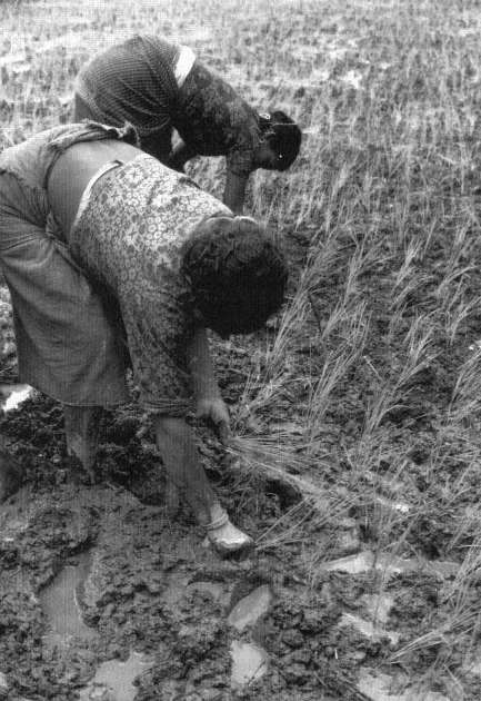
Figure 2.
Jyapu women planting rice paddy plants.
rice are brought home, whilst the straw remains in the fields to dry. . . . After the winnowing [which takes place m the farmers' quarters within the city] the grains of rice are dried for a few days in the sun if the weather is good. During this time, streets and squares, yards and roof-terraces are full of rice, which is spread out on straw mats and turned over several times. . . . After drying, part of the rice is taken to one of the [town's water-driven] rice mills and there the husk is removed. The largest part of the harvest however, is stored with the husk still on [in special granaries in the farmer's houses].
The Nonagricultural Economy
An inventory of the small stalls and shops that crowd the bazaar street gives some idea of the variety of the supplies and of the specialists who provide them, which are necessary for the material and symbolic life of Bhaktapur. There are (in no particular order) specialized shops or market areas selling: cloth for saris and clothes; ready-made clothes; Ayurvedic medicines; modern medicines; cigarettes, tobacco, and smoking supplies; rice and other grains; mustard oil, kerosene, and other fuel oils; metal cooking pots; curds; water buffalo meat; curios for the tourist trade; books; gold and silver ornaments and small religious figures in gold and silver; wood for construction; tools and nails; house paint; hair decorations and arm bangles; caps; sweetcakes; red peppers; electric goods; fruit; betel nuts; sewing thread; fertilizer; vegetables; salt; metal sheetings for roofing; woolen blankets; religious drawings and pigments for use in rituals; brass and copper pots of various kinds; brass religious images; animal feed; goats; chickens; locally made furniture; clay pots. And there are also stalls for serving tea and soft drinks, stalls for serving alcoholic beverages, stalls for serving cooked food. The shops and stalls are owned and run by members of a socioeconomic class, the sahu or shopkeepers.[14] Most of these are from the high-ranking Chathar and Pa(n)cthar groups of thar s (see chap. 5)—collectively referred to as "Shresthas[*] " or "Sresthas[*] " in some writings on the Newars—but some come from lower ranks of the traditional status system.
Besides the craftsmen, bakers, butchers, collectors and grinders of herbal medicines, spinners and weavers, blacksmiths, metal image casters, and the like who provide the goods for the shops, there are the city craftsmen—masons, carpenters, wood carvers, stone carvers, and so forth who are involved in construction and repair in the city. Finally, there are all kinds of specialized performers and providers of services—musicians of various types, ritual "dancers," barbers, medical special-
ists of various types, various kinds of priests and ritual specialists, midwives, cutters of umbilical cords, astrologers, tailors, fishermen, sweepers, and many more.
In contrast to the limited sample of specialists found in South Asian villages, Bhaktapur has a full panoply. They are, for the most part—as we shall see in following chapters—organized in the city's hierarchical system, and made use of for the symbolic life of the city.[15]
The 1971 census reported for Bhaktapur that 65.8 percent of the workforce was engaged in agriculture, 8.5 percent in commerce (shops and trade), and 8.2 percent in manufacturing, primarily crafts. The census also listed a small number of people engaged in electrical, gas, and water services (0.1 percent, some 20 people), in construction (0.8 percent, some 115 people, mostly house builders and masons), in transport and communication (1.1 percent, 153 people, including the mail service, an elementary telephone service, and truck drivers), and in finance and business (0.4 percent, some 53 people working mostly at a local branch of the Nepalese bank). The census also enumerated some 2,197 people, 15.1 percent of the economically active population, engaged in "personal and community services."[16] Many of these are the barbers, washermen, healers of various sorts, and so forth, who provide traditional services, often for patron families. Some of these providers of personal and community services work for the City Panchayat as sweepers and in repair and maintenance. Some work in the Bhaktapur administrative offices, some are teachers in Bhaktapur schools, and some, finally, of this group commute on buses, the electrified trolley (which was inaugurated in the early 1970s to connect Bhaktapur and Kathmandu), or occasionally by automobile or motorcycle to Kathmandu to work in one of the many offices of the Central Government's bureaucracy.
In short, the economy of Bhaktapur was at the time of this study concerned mostly with the production and distribution of goods and services for itself, most goods were produced and distributed within the city or its near environs,[17] few people were involved in administrative or bureaucratic jobs within the city itself, and much of the household income was "in kind" rather than in cash.[18]
Bhaktapur also had in comparison with many other modernized cities and towns in Nepal less differentiation of income. Compared to Kathmandu and Patan there is a "low level of income even for the rich people in Bhaktapur" (Acharya and Ansari 1980, 113). This is in part
because of the importance of agricultural wealth in Bhaktapur, and the extensive ownership of land by the farmers themselves.
A Summary Note
We have described a city that at the time of our study still retained many of the features which had long charcterized it. It had an enormously dense but stable population. It was a city that, in comparison with communities elsewhere m the world—and in much of Nepal—was relatively little related to larger economic and political networks. Its economy, which had a large nonmonetary component, was still heavily based on internal (including its bordering farms) production and exchange. For the city as a whole it was more of an administered than a political unit, the sources of power and decision were elsewhere, in the non-Newar national government at Kathmandu. That external administration was minimally disruptive, and it was certainly not innovative. It provided what support it could to the ongoing life of the city. Bhaktapur was then in both fact and ideology "self-sufficient" and turned in on itself. But this was nothing new. In its Malla days its political adventures were the affairs of kings and their armies and were to a very large degree—once a dynasty had established itself—external to the life of the city. The city was used to being a world in itself. Royal power, and in recent centuries Gorkhali power, had taken advantage of this as a basis for stability. The proper policy, the successful policy, was to support and encourage the city's, in our case Bhaktapur's, isolated, and self-sufficient order. Bhaktapur's dense and isolated population was almost entirely Newar and almost entirely Hindu Newar. These Newars share a tradition, an identity and a culture—in both the popular and anthropological senses of the word. Bhaktapur is in contrast to Kathmandu, to European medieval and modern cities, a unicultural city.
In the presence of such conditions, what kind of internal order did the city construct? We may, or more accurately must, begin with its system of defining, organizing, and assigning social and economic and "ritual" roles. It is a system tailor-made, as it were, for the conditions of Bhaktapur's life.