Vegetation of the Santa Ana River and Some Flood Control Implications[1]
Ted L. Hanes[2]
Abstract.—The Santa Ana River is the largest drainage system within southern California. Vegetation ranges from alluvial scrub to riparian woodland. The largest willow woodland in southern California occurs in the Prado Dam basin. Composition of vegetation-types and dynamics of vegetation in relation to flooding are discussed. Plans to alter the upper Santa Ana River are evaluated in relation to the existing and future vegetation.
Introduction
The Santa Ana River is the largest river within southern California. Its watershed covers an area of 6,263 sq. km. (2,418 sq. mi.) from the San Antonio River on the west to the San Jacinto River on the east. Most of the watershed is mountainous or hilly (3,838 sq. km. [1,482 sq. mi.]) with the remaining area being mesas and flat valleys (fig. 1).
The Santa Ana River originates in montane forests above 3,050 m. (10,000 ft.) elevation and terminates in a salt marsh at sea level, where it empties into the Pacific Ocean. Discharges average 322,000 acre-feet (AF) per year, although most of this flow is below ground except during rainstorms. Periodically the Santa Ana River experiences major flooding. During the record flood of 2 March, 1938, the Santa Ana River carried more than one AF per second as it emerged from the mountains. As a consequence, extensive stream channel alteration has been carried out in the lower half of the river below Prado Dam, built in 1941 at the head of Santa Ana Canyon. Current US Army Corps of Engineers (CE) proposals include expansion of the Prado basin by raising Prado Dam and construction of a new flood control dam at Mentone to lessen the impact of an anticipated 100-year storm.
CE alternative 5 calls for raising Prado Dam 13-m. (43-ft.) and the spillway 10.4-m. (34-ft.). The existing reservoir would be increased in size by 2,034 ha. (5,025 ac.), and 592 ha. (1,461 ac.) would be acquired below the dam in the Santa Ana Canyon to serve as floodplain lands. Alternative 6 calls for the construction of Mentone Dam to control storm runoff from a 673-sq. km. (260-sq. mi.) area. The dam and reservoir area would require 1,376 ha. (3,400 ac.) of land. Prado Dam would be raised 9.1-m. (30-ft.) and the spillway 6-m. (20-ft.). An additional 591 ha. (1,460 ac.) of land would be acquired in the Santa Ana Canyon to serve as floodplain lands.
The vegetation considered in this paper is that located in the reach between Mentone at the foot of the San Bernardino Mountains through the Santa Ana Canyon.
Literature Review
The only published description of the Mentone vegetation is by Ingles (1929). He recognized several plant associations: cottonwood/willow, Salvia /Artemisia , Adenostoma /Ceanothus and Lepidospartum /Croton . In the 1920s, the cottonwood/willow association was found throughout the wash area west of Orange Avenue and included alders (Alnus ). This entire association has since been destroyed by the establishment of rock quarries and other urban activities. Ingles considered the Adenostoma /Ceanothus and the Salvia /Artemisia association climax vegetation-types, but proposed that the cottonwood/willow and Lepidospartum /Croton associations be considered seral (successional). He acknowledged that boundaries of these plant assemblages were not well defined.
The splitting of vegetation into numerous small associations and societies in vogue in the 1920s has been replaced by the practice of designations based upon major plant groupings. Recent studies on alluvial fans in southern California designate the vegetation as alluvial scrub (Andrews 1972; Smith 1978). Smith considered the Lepidospartum /Eriogonum to be a pioneer asso-
[1] Paper presented at the California Riparian Systems Conference. [University of California, Davis, September 17–19, 1981].
[2] Ted L. Hanes is Professor of Biology and Director of the Fullerton Arboretum, California State University, Fullerton.
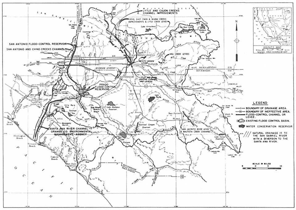
Figure 1.
Santa Ana River, California, largest river system within southern California, showing the 8,100-ha. (200,000-ac.) watershed.
Existing flood control improvements are shown. (Source: US Army Corps of Engineers, Los Angeles District.)
ciation and combined numerous half-shrubs and woody sclerophylls into a mature grouping. The fact that the alluvial vegetation contains components of coastal sage scrub (Kirkpatrick and Hutchinson 1977; Mooney 1977) and chaparral (Cooper 1922, Hanes 1976) as well as some plants of the transmontane juniper woodland make the alluvial scrub a unique vegetation-type, difficult to define or describe in ecological terms.
Less definitive treatments of the plant life of the Santa Ana River reach from Mentone to the Prado basin have been prepared. Several natural history guides are helpful, but do not provide any quantitative information (Anderson 1972a; Louis Rubidoux Nature Center 1975; Munns 1977; Riverside County Parks Dept, undated; Tri-County Conservation League 1972). The CE included some information on plant associations and plant species in its draft and final Environmental Impact Statements (US Army Corps of Engineers 1975, 1977).
The existing literature describing the flora of the Santa Ana River through Riverside, Rubidoux, Norco, the Prado basin, and Santa Ana Canyon is generally limited and sketchy in nature. Anderson (1972b) presented a brief account of human impact on the Santa Ana River starting with aboriginal influences. The first vegetation study (Howell 1929) described the woodland in its near-pristine condition. Wieslander (1934) published a detailed vegetation map of the Corona. quadrangle showing the Santa Ana River and Chino Creek as naturally wooded areas in the vicinity of what is presently the Prado basin. Little (1979) concluded that the construction of Prado Dam in 1941 did not create an artificial willow/cottonwood woodland, but simply expanded its previous boundaries by raising and extending the water table. Hanes (1980) presented the first quantitative analysis of the vegetation in the Santa Ana Canyon area.
The riparian woodland in the 6,480-ha. (16,000-ac.) Prado basin is a cottonwood/willow forest-type (Society of American Foresters 1954). Several plant lists have been prepared for the Prado basin (Howell 1929; Marsh and Abbott 1972; URS Research Company 1974). Little (1979) conducted field studies in the Prado basin and combined his findings with previous lists. The combined list contained 232 plant species belonging to 5 families of vascular plants. Of the total, 156 species (67%) were native (indigenous) and 73 (31.5%) were non-native (introduced, exotic). Little (ibid .) speculated that the Santa Ana River should have many rare and endangered species.
Hanes (1980) conducted a study from Mentone to the Santa Ana Canyon during the spring of 1980 and reported 65 families of vascular plants which included 428 species. Of these, 330 (77%) were native and 98 (23%) were non-native species.
Methods
The Mentone vegetation was sampled extensively using the line-intercept method. Base lines were established every 50–100 m. in major sectors of the alluvial fan. At intervals of 20 m., a 10-m. intercept transect line was placed at right angles to the base line. One transect line was laid to the right and the next line to the left in alternating fashion. The crowns of all perennial shrubs that overlapped or intercepted the transect line were recorded by species, to the nearest 5 cm. crown length. This rapid technique is considered the most efficient and accurate method of sampling full-crowned shrubs (MuellerDombois and Ellenberg 1974). The accumulated length occupied by any one species out of the total transect line length used for the sample was expressed as the percent cover for that species.
Riparian woodland vegetation was sampled using 3.3- × 30-m. continuous transects placed at random throughout the woodland stands between Riverside and the Santa Ana Canyon. Trees were recorded by species as alive or dead. Their estimated trunk diameters at breast height (DBH) were placed in one of the following size-classes: 2–6, in., 7–12 in., 13–24 in., 25–48 in. The enumeration of trees by species within the 3.3- × 30-m. plots allowed the calculation of tree density; i.e., the number of each species per unit area (ibid .).
Herbaceous plants were sampled using a 1- × 1-m. quadrat subdivided into 100-dm. squares. Only percent cover by species was determined since individuals in many cases were impossible to determine. Furthermore, percent cover gives a better measure of plant bulk (biomass) than does the number of stems or individuals (ibid .).
Three parameters of vegetation were assessed. These were density (number of plants of a species per plot), cover (size of crown of the plant), and frequency (number of subplots in which a species occurs). Importance value (IV) is a composite of these three vegetation parameters. It was determined by summing the relative density, relative cover, and relative frequency of a species. Relative values for each species were obtained by dividing each vegetation by the total of all species.
Vegetation Structure and Floristics
Mentone
Four vegetation-types were recognized on the Mentone alluvial fan. The most extensive vegetation-type was juniper woodland. A total of 327 line intercepts were established in the woodlands east of Orange Avenue. Juniper (Juniperuscalifornica ), by virtue of its size, dominated the vegetation, but smaller shrubs such as Eriogonumfasciculatum , Eriodictyontrichocalyx , Opuntialittoralis , and Gutierrezia sp. were important in terms of percent cover, percent density, and percent frequency. Thirty-two additional shrub species were found in the woodland. Over 43% of the Eriogonum was dead, even though the species had the highest importance value (IV). This was true of the other dominant species except Juniper, which had the lowest dead IV.
The juniper woodland west of Orange Avenue was sampled to compare it with the more extensive woodland east of Orange Avenue. Here the woodland was similar to that east of Orange Avenue in perennial shrub composition and structure, but the IVs were generally lower. This was due in part to the area being used extensively as an unauthorized dump; and perhaps the groundwater supply is lower since it lies between the Santa Ana River and Plunge Creek and the normal drainages from the east have been blocked by Orange Avenue.
Alluvial scrub occupied the younger frequently disturbed sites. This vegetation-type was also dominated by Eriogonum fasciculatum , which had an IV greater than any other shrub species. Other dominant but less frequent shrubs were Adenostomafasciculatum , Eriodictyon trichocalyx , Lotusscoparius , Artemisiacalifornica , and Rhusovata . Only 17 shrub species comprised the alluvial shrub vegetation.
The riparian woodland found on the Mentone alluvial fan was poorly developed and a minor component of the vegetation. It was dominated by California sycamore (Platanusracemosa ), but these were small, drought-stunted trees that hardly formed a woodland. Other tree species, such as willow or cottonwood, were found only rarely. More commonly, shrubs such as Eriogonumfasciculatum , Yuccawhipplei , and Opuntialittoralis , were associated with the sycamore trees along old, as well as active, watercourses.
Herbaceous plants were abundant in the juniper woodlands. The average number of plants was 62 per sq. dm. in the woodland east of Orange Avenue, and 26 per sq. dm. in the woodland west of Orange Avenue. The species number was also higher east of Orange Avenue (25); west of Orange Avenue it was only 18.
Riverside to Norco Reach
Extensive riparian woodlands occur in the Riverside-Norco reach of the Santa Ana River. Gallery cottonwood forests are found in the Riverside-Rubidoux reach. Nearly continuous young riparian woodlands are found in the Rubidoux-Norco reach. These were sampled but the data are not presented in this paper.
Prado Basin
Due to the major flooding of the Prado flood basin during February 1980, a quantitative vegetation analysis could not be performed at the time of the field study.
Qualitative assessments by direct observation from viewing points and other places around the basin perimeter are presented here. About 80% of the Prado basin was covered by extensive areas of riparian woodland, dominated by dense stands of arroyo willow (Salixlasiolepis ), black willow (Salix gooddingii ), and Fremont cottonwood (Populus fremontii ). Other woodland trees dominant by size but scattered in distribution were California sycamore, black cottonwood (Populustrichocarpa ), red willow (Salixlaevigata var. araquipa ), and golden willow (Salixlasiandra ).
The riparian woodland trees in the basin had withstood more than 12 weeks of inundation during their dormant (deciduous) stage without apparent ill-effects. While standing in water these trees were developing a full crop of leaves, flowering, and bearing fruit. The trees showing this amazing adaptation to flooding were the willows, cottonwood, and sycamore. Furthermore, fallen trees, broken limbs, and other tree parts left by the eroding action of floodwaters were actively taking root and sprouting vigorously where floodwaters had receded.
Santa Ana Canyon
The vegetation in the upper end of the Santa Ana Canyon was mainly gallery-type riparian woodland. A major stand grew between Prado Dam and the golf course. A second woodland dominated the Featherly Park area. Some isolated riparian shrubs and perennial herbs occurred between Featherly Park and Imperial Boulevard, but in this reach the riverbed was composed of recently deposited sand and other alluvia with limited vegetation.
The woodland composition below Prado Dam is shown in table 1. Willows dominated (91% of the stands); these trees were in the 2–6 in. DBH size-class. Less than 10% of the woodland was composed of Fremont cottonwood; like the willows the majority had small trunks. About 29% of the woodland trees were in the size-class 7–12 in. DBH. The willow density was 1,250 per ha. (506 per ac.) whereas the cottonwood density was 114 per ha. (46 per ac.). Of the trees present, about 20% were dead, standing or fallen. In the woodland below the dam some riparian shrubs such
| ||||||||||||||||||||||||||||||||||||||||||||||||||||||||||||||||||||||||||||||||||||||||||||||||||||||||||||||||
as shrub willows and mulefat (Baccharisglutinosa ) formed a broken understory. However, these shrubs were found mainly on the woodland margins and were not sampled. Due to the heavy flooding of this woodland stand, the soil surface was either washed or covered with sand and silt deposits to various depths ranging up to 40.6 cm. (16 in.). Little or no herbaceous growth had become established on these recent deposits.
The woodlands in the Featherly Park reach also had considerable shrub understory, making access very difficult. The understory was composed of seedlings of willow with trunks less than 2 in. in diameter and mulefat. The understory was further complicated by dense root sprouts from downed willows and clumps of giant reed (Arundodonax ). Natural breaks in the woodland occurred randomly and represented past flooding events of erosion or deposition. These sites were filled with dense stands of mulefat. Over a period of time these shrub areas may succeed to woodlands.
Impacts of Proposed Flood Control Projects
Construction of Mentone Dam and Reservoir and the realignment of Mill Creek and levee, as proposed by the CE, would have a major impact on the existing vegetation. The borrow pit would destroy over 200 ha. (500 ac.) of native juniper woodland and alluvial scrub vegetation. This would be a significant loss since the Mentone alluvial fan vegetation represents the largest stand of California juniper on the coastal side of the Transverse Ranges in southern California. Further, urban pressures elsewhere have reduced, altered, or destroyed the vegetation on other alluvial fans in coastal southern California. The presence of species such as Lepidospartumsquamatum , unique to alluvial fans and washes, and the mixture of coastal sage scrub with chaparral species makes the vegetation unique to southern California. The springtime meadowland created by numerous species of herbaceous plants would be destroyed by inundation. This component of the vegetation is a carpet of herbaceous, annual flowering plants, between the shrubs, that flourishes during the sring months and then dies off with the onset of summer.
The existing percolation basins clearly indicate that junipers, all herbaceous plants, and many of the perennial plants that make up the alluvial scrub vegetation could not tolerate inundation. Plants remaining after grading operations are completed and the dam is operational would be killed if exposed to short episodes of inundation. The proposed recreational area of 121 ha. (300 ac.) would lie partially below the take line and would be subject to infrequent inundation episodes. If the Mentone Dam is constructed, sycamore, other riparian trees, shrubs adapted to the alluvial environment, and shrubs that can withstand inundation should be planted instead of inundation-intolerant species.
Human activity in the remaining natural and recreation areas would not greatly affect the perennial vegetation. However, foot traffic and other uses would have an impact on the annual herbaceous cover.
Within the Prado basin, the impact of flooding on the woodland trees seems minimal. To date they have been able to withstand at least three months of inundation without apparent damage. Whether they can continue to do so is unknown. The riparian shrubs can survive shorter periods of inundation, perhaps several weeks. Herbaceous vegetation and most agricultural crops would be affected by flooding, erosion, siltation, and inundation. The higher the frequency of inundation the greater the impact on herbaceous plants.
If material is taken from the basin for the construction of Mentone Dam, several hundred acres of riparian woodland will be destroyed. The borrow pit may be turned into four small lakes or one large lake for recreational purposes. If shoreline grading is required, this would further destroy riparian woodland vegetation. Small trees replanted to replace mature trees are not equivalent in stature, aesthetics, wildlife habitat value, or time.
Below Prado Dam the impacts of CE alternates 5 and 6 would result from the infrequent releases of volumes of water up to five times that of present release rates. Such high volumes would have major impacts on the riparian woodlands. All types of plants, even mature trees, would suffer from the erosive action and sheer weight and velocity of the water. Existing small channels and riverbanks would be altered or destroyed. Within the more stable woodlands, herbs, shrubs, tree seedlings, and downed dead wood would be swept away. As trees were dislodged and swept downstream, they would become obstructions in the main river channel. Ultimately, they would be swept out to sea.
The above impacts would be accentuated if more water was retained in the basin, since less water would be released in minor storms than at present. This would allow more trees, shrubs, herbs, and other understory plants to establish themselves in the main river channels before they were exposed to the impact of a major release of water. More frequent but less intense flooding would keep the woodland vegetation in a more juvenile stage of develoment; consequently it would show less impact from a major water release.
Mitigation
1. The loss of prime juniper woodland could be partially mitigated by acquiring the woodland west of Orange Avenue. Although it lacks the richness of that east of Orange Avenue, it does possess the same structure and general physiognomy. This acquisition would insure that this woodland would not be lost to urbanization.
2. Wherever suitable, plantings of groundcover, shrubs, and trees that are native and otherwise adapted to the site should be used. The present species could be augmented with such species as Alnusrhombifolia , Salix sp., and shrubs found on other alluvial fans in southern California.
3. All plantings around the proposed lake(s) should be species known to be able to withstand the riparian conditions of wet soil, flooding, and inundation.
4. Certain native riparian plants could be introduced to augment the species present. Alnusrhombifolia , Acermacrophyllum , and Umbellulariacalifornica would be suitable additions.
5. Inundation episodes in the upper zones of the Prado Reservoir should not be allowed to last over three weeks, in order to avoid killing off the herbaceous understory plants and agricultural crops.
6. The projected release volumes from Prado Dam should be reduced. This would reduce the impact on the riparian woodlands below the dam and in the Featherly Park reach. Since the reach below the dam is designated as a greenbelt, the devastating effects of massive water release on the riparian woodlands should be reduced or avoided.
Literature Cited
Anderson, E.N. 1972a. Western Riverside County: a natural history guide. 33 p. Anderson Publcations, Sunnymead, Calif.
Anderson, E.N. 1972b. Man on the Santa Ana: a brief account of human management of a land. 10 p. Tri-County Conservation League, Riverside, Calif.
Andrews, P.W. 1972. Ecology of a southern California floodplain. Ph.D. Thesis, Claremont Graduate School, Claremont, Calif. 300 p.
Cooper, W.S. 1922. The broad-schlerophyll vegetation of California. An ecological study of chaparral and its related communities. 124 p. Carnegie Inst. Wash. Publ. 319, Washington, D.C.
Hanes, T.L. 1976. Vegetation types of the San Gabriel Mountains. In : Symposium proceedings: plant communities of southern California. Special Publ. Calif. Native Plant Soc., Berkeley, Calif. 164 p.
Hanes, T.L. 1980. Environmental appendix to the final Phase I general design memorandum and the final supplemental environmental impact statement—Santa Ana River main stem including Santiago Creek and Oak Street drainage. U.S. Engineer District, Los Angeles, Calif.
Howell, J.T. 1929. The flora of the Santa Ana Canyon region. Madroño 1:243–253.
Ingles, L.G. 1929. The seasonal and associational distribution of the fauna of the upper Santa Ana River Wash. J. Entomology and Zool. 21:1–45, 57–96.
Kirkpatrick, J.B., and C.F. Hutchinson. 1977. The community composition of California coastal sage scrub. Vegetatio 35(1):21–23.
Little, R.J. 1979. Floristic overview of the Prado Dam flood control basin, Part II—existing biotic environment. 5 p. Santa Ana Watershed Project Authority, by ECOS management criteria, Tustin, Calif.
Louis Rubidoux Nature Center. 1975. Plant communities of the Santa Ana River Regional Park, Rubidoux, Calif. 8 p. Riverside County, Riverside, Calif.
Marsh, G.A., and K.D. Abbott. 1972. Plants and animals of the Santa Ana River, Orange County. Orange County Flood Control District Publ. No. 27, Santa Ana, Calif. 50 p.
Mooney, H.A. 1977. Southern coastal scrub. In : M.G. Barbour and J. Major (eds.). Terrestrial vegetation of California. 1,002 p. Wiley Interscience, New York, N.Y.
Mueller-Dombois, D., and H. Ellenberg. 1974. Aims and methods of vegetation ecology. 541 p. John Wiley and Sons, New York, N.Y.
Munns, Bob. 1977. Flora of the Rubidoux Nature Center. 6 p. Natural Science Section, Angeles Chapter, Sierra Club, Los Angeles, Calif.
Riverside County Parks Dept. Undated. Willow Flats trail, nature trail guide. Prado Basin Regional Park, Norco. 5 p.
Riverside County Parks Dept. Undated. Checklist of the common plants associated with the Santa Ana River Regional Park, Riverside, Calif.
Smith, R.L. 1978. The alluvial scrub vegetation of the San Gabriel River floodplain, California. M.A. Thesis, California State University, Fullerton. 43 p.
Society of American Foresters. 1954. Forest cover types of North America. 67 p. Society of American Foresters, Washington, D. C.
Tri-County Conservation League. 1972. The living Santa Ana River. 31 p. Tri-County Conservation League, Riverside, Calif.
URS Research Company. 1974. Environmental baseline inventory of the Santa Ana River basin. 83 p. Prepared for the Santa Ana Watershed Planning Agency. Santa Ana Calif.
US Army Corps of Engineers. 1975. Draft environmental statement Santa Ana River Basin and Orange County, Los Angeles, Calif. 354 p. U.S. Army Corps of Engineers, Los Angeles, Calif.
US Army Corps of Engineers. 1977. Draft environmental statement. Review report on the Santa Ana River main stem—including Santiago Creek and Oak Street drain for flood control and allied purposes. 126 p. Office of the Chief of Engineers, Department of the Army, Washington. D.C.
Wieslander, A.E. 1934. Vegetation types of California. Corona quadrangle map. From a series of topographic botanical maps: vegetation types by California Forest and Range Experiment Station of the USDA. Forest Service Surveyed 1931 and Revised 1934.