20—
THE RIVERS AND HARBORS ACT, SECTION 404, AND RIPARIAN SYSTEM CONSERVATION
Federal Wetlands Protection under the Rivers and Harbors Act of 1899
An Historical Overview[1]
Kent G. Dedrick[2]
Abstract.—The nation's wetlands, ranging from small streams to major navigation channels, now enjoy protection under Section 404 of the Clean Water Act and Sections 9 and 10 of the Rivers and Harbors Act of 1899. Both acts have increasingly been the subjects of hard-fought court actions and Congressional debate. U.S. Army Corps of Engineers (CE) jurisdiction and historical developments dealing with the 1899 Act are summarized here. Examples of CE jurisdiction and permit and enforcement activities, mainly dealing with the San Francisco Bay estuarine system, are given.
Introduction
Estuaries and fresh water streams are clearly essential to California's inland and ocean fisheries. In addition, riparian wetlands and forest systems are equally dependent upon adjacent waterways, as they serve both to irrigate riparian vegetation and to provide a food supply for avian, amphibian, and mammalian inhabitants of the riparian system. Because of this, biologists, engineers, and citizens interested in these areas can profit from a basic understanding of the governmental protections that are available to prevent damage to waterways.
In some states, waterways are subject to a number of state and local laws or ordinances. But in all states, the federal Rivers and Harbors Act of 1899 (1899 Act)[3] and the more recent (1972) Section 404 of the Clean Water Act (Section 404)[4] are applicable. These acts establish an important mechanism in which a permit must be issued by the U.S. Army Corps of Engineers (CE) before any "work" can be commenced in ocean waters, estuaries, rivers, streams, lakes, or in wetlands. The purpose of this paper is to provide a basic introduction to the 1899 Act and give a short history of its administration and enforcement, to review recent attacks upon the CE permit system, and to discuss the extent of CE jurisdiction. In addition, a few comments dealing with Section 404 are appropriate in order to help keep federal wetland protections in perspective.
From the standpoint of environmental protection, the jurisdiction issue is of pivotal importance. The reason for this is simply that the federal Fish and Wildlife Coordination Act[5] requires that the CE "shall first consult" the USDI Fish and Wildlife Service (FWS) and the state wildlife agency (e.g., the California Department of Fish and Game) regarding all applications to the CE for permits in areas of waterways or wetlands under CE jurisdiction. In addition, if the proposed work is deemed sufficiently damaging to the environment, an environmental impact statement (EIS) will be required under the National Environmental Policy Act (NEPA).[6] Neither of these protections is available if the area where the work is proposed lies outside the jurisdictional limits of the CE.
The jurisdiction issue is so clearly recognized that opponents of the 1899 Act and Section 404 have concentrated recent attacks upon both laws at this critical point. In addition, recent litigation concerning application of both laws to specific proposed projects has often centered upon this same point: CE jurisdiction.
[1] Paper presented at the California Riparian Systems Conference. [University of California, Davis, September 17–19, 1981.]
[2] Kent G. Dedrick is Research Program Specialist, State Lands Commission, Sacramento, Calif. The views and opinions expressed are exclusively those of the author and do not necessarily reflect the official policies of the State of California or the State Lands Commission.
[3] Sections 9, 10 etseq . 33 U.S.C. Section 401 et seq . Enacted 1899.
[4] Section 404, 33 U.S.C. Section 1344 (a)(t). Enacted 1972, with amendments in 1977.
[5] 16 U.S.C. Section 661 etseq .
[6] 42 U.S.C. Section 4321 etseq .
Prior to the 1972 Congressional adoption of Section 404, federal protection of navigable waters was based upon the 1899 Act alone. As will be explained below, the history of administration of the 1899 Act during the first few decades of its existence was almost serene compared with that seen following the end of World War II. During the late 1960s and early 1970s, CE administration of the 1899 Act came under sharp Congressional review. As a result, a number of badly needed reforms were instituted. These reforms exhilarated environmentalists, but a counterattack was not long in coming from a broad range of development interests.
On a separate front, during the 1960s and 1970s wildlife agencies along with hunting, fishing, and environmental groups joined together in pitched battle against federally assisted stream channelization projects (over 21,000 linear miles of natural streams in the United States had been replaced by drainage ditches by 1972). Due to a few quirks in existing law, stream channelization projects received at best only spotty environmental review, and mitigation measures were largely meaningless.
With this background, Congressional passage of Section 404 in 1972 and the court rulings in U .S . v. Holland (1974)[7] and NRDC v. Callaway (1975)[8] provided welcome protection, since these two rulings carried CE permit jurisdiction under Section 404 well into the kind of streams and wetlands that had suffered such severe devastation through stream channelization projects. A revolt against the jurisdiction and apparatus of Section 404 was quickly mobilized, and in 1976–77 the newly won broad CE jurisdiction was nearly lost in Congress; another major attack upon it is now underway. The Section 404 experience has been described in the review by Kramer (1983), and it is recommended that the reader consult this work for further details.
The origins of the 1899 Act, its later history, and CE jurisdiction under it are discussed in the following section, which in the interest of completeness also includes a brief discourse on tidal datums and their relation to CE jurisdiction under this act.
The Rivers and Harbors Act of 1899
Origin and History
For many decades, the CE has been responsible for protecting and improving the waterways of the nation. This responsibility arose as early as 1824 through Congressional action aimed at improving navigation in the Ohio and Mississippi rivers, through the removal of sand bars and snags.[9] At that time, waterways were the primary highways for the young nation's commerce. With no railroads, freeways, or airlines, the CE in effect served the nation's major transportation needs in these waterways almost single-handedly.
"Almost," one should emphasize, for as early as 1795 the Third Congress spelled out the need for hydrographic surveys of the Atlantic sea-coast. In 1807, at the recommendation of President Jefferson, Congress adopted a resolution authorizing a "survey of the coast" (Shalowitz 1964). This 1807 Organic Act established the U.S. Coast Survey, which later became the U.S. Coast and Geodetic Survey, and is now the National Ocean Services. Fortunately, the early direction of the U.S. Coast Survey aimed at achieving the highest scientific standards in performing these important tasks. As a result, their early topographic and hydrographic survey maps of United States coasts and navigable waters are today recognized as an invaluable physical and cultural research resource.
Thus the basic governmental tools needed for expanding commercial use of waterways were in place 150 years ago; namely, good navigation charts prepared by the U.S. Coast Survey, and physical improvements to navigation performed by the CE.
Throughout early European and Mediterranean history, the acts of a few often threatened to spoil waterways as pathways for commerce, and in some cases to seize control of them. It was to be no different when the United States became a nation. The matter became critical in 1888, when the U.S. Supreme Court ruled in Willamette Iron Bridge Co . v. Hatch[10] that the federal government had no "common law" authority to protect navigable waters from obstructions. As Koonce explained in 1926 in the Koonce Lecture:
. . . while the Government was expending hundreds of millions of dollars to increase the facilities of navigation, interested parties, including States, Corporations and individuals, were placing obstructions and impediments of all kinds in and across the improved water-
[7] 373 F. Supp. 665 (M.D. Fla. 1974).
[8] 392 F. Supp. 685, 686 (D.D.C. 1975).
[9] See, for example, a lecture by Judge G.W. Koonce, "Federal Laws Affecting River and Harbor Works," Company Officer Class, the Engineer School, Fort Humphreys, Virginia, April 23, 1926 (reprinted in "Hearings on Water Pollution Control Legislation—1971," House Committee on Public Works, 92 Congress, 1st Session 286 [1971]), hereafter referred to as "Koonce Lecture.
[10] 125 U.S. 1 (31 Law Ed. 629)(1888). In this case, the Oregon Legislature in 1878 had authorized construction of a draw bridge across the Willamette River in Portland. Bridge foundations restricted the channel width to 87 ft.—it had formerly allowed passage of seagoing vessels of 2,000 tons for a mile upstream from the bridge.
way. The necessity for Federal legislation to protect these waterways from impairment and ultimate destruction eventually became urgent.
The reaction of Congress was swift. In the Rivers and Harbors Act of 1890 (1890 Act),[11] Congress authorized the basic concepts of the permit authority of the CE.[12] No longer saddled with the Willamette court's refusal to use the common law as the basis for federal authority in navigation disputes, after 1890 this authority became firmly based upon the Commerce Clause of the U.S. Constitution:[13]
The Congress shall have Power . . . To regulate Commerce with foreign Nations, and among the several States, and with the Indian Tribes;
There were problems with the 1890 Act and in 1896, Congress directed the Secretary of War to review existing laws and prepare revisions and amendments that he believed would be in the public interest. As an active participant, Koonce tells us that these recommendations were prepared as a bill that was to be independent of an appropriations bill, adding:
. . . but it slumbered unnoticed for nearly three years, and when we had about concluded it would never receive any attention whatever, it was taken up and passed in the most unexpected manner. (Koonce Lecture)
What happened was that while the 1899 Rivers and Harbors Appropriations Act was being considered by the Senate (it had already passed the House), Senator Frye, then Chairman of the Senate Commerce Committee, introduced what we now know as Sections 9 to 21 of the 1899 Act as an amendment to the appropriations bill.
This important language, said Koonce, was "accepted by Congress without the change of a word and practically without debate or discussion," (Koonce Lecture) apparently in the belief that Sections 9 and 10 did little more than restate existing law. Section 9 of the 1899 Act reads in full as follows:
It shall not be lawful to construct or commence the construction of any bridge, dam, dike, or causeway over or in any port, roadstead, haven, harbor, canal, navigable river, or other navigable water of the United States until the consent of Congress to the building of such structures shall have been obtained and until the plans for the same shall have been submitted to and approved by the Chief of Engineers and by the Secretary of the Army: Provided , That such structures may be built under authority of a legislature of a State across rivers and other waterways the navigable portions of which lie wholly within the limits of a single State, provided the location and plans thereof are submitted to and approved by the Chief of Engineers and by the Secretary of the Army before construction is commenced: And provided further , That when plans for any bridge or other structure have been approved by the Chief of Engineers and by the Secretary of the Army, it shall not be lawful to deviate from such plans either before or after completion of the structure unless the modification of said plans has previously been submitted to and received approval of the Chief of Engineers and the Secretary of the Army.
Section 10 of the 1899 Act reads in full as follows:
The creation of any obstruction not affirmatively authorized by Congress, to the navigable capacity of any of the waters of the United States is prohibited; and it shall not be lawful to build or commence the building of any wharf, pier, dolphin, boom, weir, breakwater, bulkhead, jetty, or other structures in any port, roadstead, haven, harbor, canal, navigable river, or other water of the United States, outside established harbor lines, or where no harbor lines have been established, except on plans recommended by the Chief of Engineers and authorized by the Secretary of the Army; and it shall not be lawful to excavate or fill, or in any manner to alter or modify the course, location, condition, or capacity of any port, roadstead, haven, harbor, canal, lake, harbor of refuge, or inclosure within the limits of any breakwater, or of the channel of any navigable water of the United States, unless the work has been recommended by the Chief of Engineers and authorized by the Secretary of the Army prior to beginning the same.
But much more was involved. Section 9 of the 1899 Act requires Congressional consent and CE approval before construction of any bridge, dam, dike, or causeway "over or in" navigable waters of the United States. (The 1890 Act provided such protection only in the cases of bridges and causeways.) Under Section 10 of the 1899 Act, any structure, excavation, or fill that would "alter or modify the course, location, condition, or capacity" of navigble waters of the
[11] Act of Sept. 19, 1890, Ch. 907, Section 7, 26 Stat. 454, as amended by Act of July 13, 1892, Ch. 158, Section 3, 27 Stat. 110.
[12] For a more detailed history, see Barker (1976)
[13] U.S. Constitution, Article I, Section 8.
United States requires a CE permit. (Under the 1890 Act, the CE could regulate only a much-narrower class of activities that would "obstruct or impair navigation, commerce, or anchorage.")
Since 1899, thousands of CE permits under Section 10 have been issued, and important court rulings affirming the validity of the CE permit program are now the classical literature on this subject. Judge Koonce worked for the CE for 40 years, beginning in 1886, and was a key figure in the development of the 1899 Act; he also continued to guide its administration for many years. He concluded his 1926 address noting that the 1899 Act:
. . . has been in force for 27 years, and in all that time there has been no amendment or suggestion of amendment. It has been contested in the courts and the constitutionality of many of its provisions has been questioned, but so far it has withstood all assaults. (Koonce Lecture)
All regulatory programs in government are subject to "assaults," and the CE permit program was no exception. The classic and continual dilemma for an agency regulator is the matter of posture under stress. Does one take a "hard line" and risk the entire program, or does one make accommodation for particular projects where undue political pressures may be exerted upon elected officials and thereby weaken or even cripple the program?
Section 9 of the 1899 Act is a case in point. Its strong language requiring approval by Congress or a state legislature for work that obstructs navigation "over or in" waterways became a case where accommodation prevailed. During his 1926 lecture, Koonce stated that Section 9 applied only "to that class of structures such as bridges and dams which extend entirely across a waterway" (Koonce Lecture)—a considerably restricted interpretation that became the administrative practice of the CE, and recently won favor in a 4th Circuit Court ruling.[14]
Since 1899, on the West Coast at least, some changes in regulatory posture have apparently occurred. For example, since 1905, in south San Francisco Bay nine Section 9 permits for dams across tidal sloughs have been issued; all were issued before 1930. During the 1930s Depression, permit activity was minimal, but, largely after World War II, at least another nine projects involving the damming of many more sloughs were either authorized under Section 10 or completed with no permit whatsoever.[15] The sloughs involved ranged in width from about 100 ft. to well over 500 ft., some have documented histories of commercial navigation, and most would be suitable for present and future uses in navigation.
Colorful history sometimes appears in CE records. For example, in 1905 CE permission was granted for a dam across Phelps Slough in south San Francisco Bay near Redwood City, and the dam was duly put in place. But unknown to District Engineer Major Wm. M. Harts, former California Governor James H. Budd owned a villa and boat dock on the slough landward of the dam site. CE records show that Governor Budd "made protest and subsequently caused the dam to be blown out." With the dam out of the way, both Budd and the operator of a schooner landing on the slough could again enjoy free navigation into San Francisco Bay. Unfortunately, at some time in the 1950s the slough was again dammed, but no permit for the dam has been located.
Two of these sloughs in San Francisco Bay were declared navigable by statute enacted by the California Legislature,[16] but despite strong citizen protest, they were eventually rendered useless for public navigation. During the years that so many waterways were lost to the public, Section 611 of the California Penal Code was in force and warned that "Every person who unlawfully obstructs the navigation of any navigable stream is guilty of a misdemeanor." Although this section was repealed in 1937, obstruction of navigable waters remains a public nuisance, subject to abatement.[17]
Criticism and Reform
As will become apparent below, an increased attack on the nation's estuaries, streams, and wetlands occurred following World War II. It seems fair to say that the attack peaked during the 1960s, but was arrested in the counterattack of increased environmental awareness in 1970. Congress had strengthened the Fish and Wildlife Coordination Act in 1958, but that action did not prove sufficient to stem losses of irreplacable wetlands.
In 1967, hearings were held by the House Subcommittee on Fisheries and Wildlife Conservation, chaired by Rep. John D. Dingell,[18] at which the extent of estuarine environment losses was
[14] Hart and Miller Islands v. Corps of Engineers , etc . 621 F 2d 1281 (1980).
[15] Corps of Engineers records, San Francisco District, San Francisco, Calif.
[16] Many California waterways have been declared navigable by statute (see Harbor and Navigation Code, Sections 101 to 106), although a statutory designation is not necessary for their judicial recognition as such (e.g., Churchhill Co . v. Kingsbury , 178 Cal. 554; 174 P. 329 [1918]).
[17] Civil Code Sec. 3479 and Code of Civil Proc. Sec. 731.
[18] Estuarine Areas. Hearings before the Subcommittee on Fisheries and Wildlife Conservation, Committee on Merchant Marine and Fisheries. U.S. House of Representatives, 90th Congress, 1st Session, March 6, 8, 9, 1967. (Hereafter "Dingell Hearings".)
revealed on a nationwide basis. Dr. Stanley A. Cain, then the Assistant Secretary of the Interior for Fish and Wildlife and Parks testified that during the previous 20 years alone, 564,500 ac. of estuarine environment in coastal estuaries had been lost to dredging and filling, while another 4,300 ac. in shoal areas of the Great Lakes were lost as well. The total losses were 7% of the some 8 million acres of estuarine environment in the 26 states considered.
California's losses were cited as greater than the combined losses of the next four most heavily impacted states: Texas, Louisiana, Florida, and New Jersey. According to Cain's figures, 75% of Caifornia's estuarine losses occurred in the San Francisco Bay-Suisun Bay area. In fact, these bay area losses of 300 sq. mi. extended over a period somewhat longer than 20 years. Much of the area is diked (but not filled) and so in principle retains the potential for restoration.
During the Dingell Hearings, scenarios of the loss of many wetland areas were detailed. For example, during a brief six months in 1962, eight projects involving a total of nearly 3 million cubic yards of dredge and fill work in Hempstead Bay (Long Island, N.Y.) had been approved by the CE over strong objections by the FWS and the New York State Conservation Department. Of many other documented examples of Long Island "dredge the bays fill the wetlands" projects noted during the 1960s, some were commenced with no CE permit whatsoever, and some were even approved by the USDI Bureau of Sports Fisheries and Wildlife (BSFW). Between 1936 and 1961, 14,000 ac. of the original 30,000 ac. were lost on the south shore of Long Island alone; while as of 1952, 12.5% had been lost during the preceding five years. Testimony from other states revealed a similarly bleak picture.
Some CE procedures left the Fish and Wildlife Coordination Act as an empty promise. For example, in 1963 public notices for proposed projects published by the Jacksonville District (Florida) CE contained the warning that protests must be "based on the effects on public navigation" alone, and that the federal courts had ruled that CE decisions on the permit must not be based on "considerations having nothing to do with navigation." By 1966, public notice language had improved somewhat, so that issuance of a CE permit "merely expresses the assent so far as the public rights of navigation are concerned," leaving open the door to protests on other grounds.
The Dingell Hearings were ostensibly held to consider nine bills, all containing the language: No person may conduct any dredging, filling, or excavation work within any estuary of the United States or in the Great Lakes and connecting waterways unless a permit for such work is issued by the Secretary of the Interior. That is, these bills would have required dual permits from federal agencies; one issued by the CE and one by the U.S. Department of the Interior (DI).
In the aftermath of the Dingell Hearings, Secretary of the Army, Stanley Resor, and Secretary of the Interior, Stewart Udall, on 13 July 1967 signed a Memorandum of Understanding setting forth procedures to be followed in treating CE permit applications for work that "will unreasonably impair natural resources . . . including fish and wildlife and recreational values." In such cases, the CE will "either deny the permit or include such conditions in the permit" as will be "in the public interest." Because of this action, the dual permit legislation was dropped, and a wait-and-see posture was taken to give this new proposal a chance to prove itself. This important memorandum, and the authority of the CE to deny permits for works that would unreasonably impair natural resources, has since been affirmed in an important court action centered on Florida's west coast.
On the palm-fringed shores of Boca Ciega Bay (an arm of Tampa Bay near St. Petersburg, Florida), two landholders, Alfred Zabel and David Russel, wanted to build a trailer park on the shallow waters of the bay near its shoreline. It would be a dredge and fill operation with the dredged material piled up to form an island, connected to the shore with a dirt berm so that the house trailers could get from shore to the new island.
Zabel and Russel began obtaining local agency permits, ran into a problem, and sued in Florida courts, finally winning in Florida's Supreme Court. They next tackled the federal problem and filed application for a CE permit under the 1899 Act. A public hearing was held in November 1966, where other state and local agencies and numerous citizens protested against the project. A month later, Colonel R.P. Tabb, District Engineer, Jacksonville District, CE, recommended that although "the proposed work would have no material adverse effect on navigation," the "continued opposition of the U.S. Fish and Wildlife Service" as well as the other protests, "convinced me that approval . . . would not be in the public interest." Secretary of the Army, Resor, denied Zabel and Russel's application on 28 February, 1967, only a week before the Dingell Hearings commenced.
The two prospective developers and their attorneys set to work and filed a complaint in U.S. District Court a few weeks later on 10 May, 1967. They charged that the CE had no authority to deny the permit, and on 17 February, 1969, District Judge Krentzman agreed, stating that Resor did not have authority to deny a permit in cases "where he has found factually that the construction proposed . . . would not interfere with navigation."[19]
[19] 269 F. Supp. 764 (M.D. Florida, 1969).
The CE appealed Krentzman's ruling before the Fifth Circuit, and that court reversed the ruling on 16 July, 1970, in an opinion in which Judge Brown stated bluntly that "the Corps does not have to wear navigational blinders when it considers a permit request."[20]
"Hallelujah! That is great!" exclaimed Representative Henry S. Reuss on hearing news of the reversal a few days later, while he was conducting the hearings: "Protecting America's Estuaries—The Potomac" before the Subcommittee on Conservation and Natural Resources.[21] "That relieves us of new legislation!" added Representative Paul N. McCloskey, Jr., a member of Reuss' subcommittee.
To no one's surprise, Zabel and Russel appealed the Fifth Circuit's decision to the U.S. Supreme Court, which in 1971 declined to review the case. As a result, the legal apparatus for CE denial of permits on the basis of wildlife concerns (and others not substantively involving navigation) was firmly in place. The 1967 Memorandum of Understanding referred to above and the Zabel v. Tabb decision together formed the foundation that was to make the Fish and Wildlife Coordination Act a powerful tool for environmental protection.
But the euphoria following the 1967 Memorandum of Understanding was to be badly shaken in October of that same year in a case involving landfill at Hunting Creek, along the west shore of the Potomac River and only 7 mi. from the nation's Capitol. The Hunting Creek affair was called a "debacle in conservation".[22]
In this case, a slim wedge of underwater property (36 ac.) jutting one-half mile out into the Potomac was proposed to be filled for apartments and crowned with a drive-in movie at its apex. The Teamsters Union Pension Fund (represented by contractor Howard Hoffman Assoc.) and an apartment firm each claimed ownership of the property, the winter home of thousands of diving ducks. The landfill would be immediately offshore from Jones Point Park (National Park Service), site of an historic (1855) lighthouse that once guided Potomac navigators.
A 1964 CE permit application was vigorously protested by the National Parks Service (NPS), FWS, six Congressmen, a U.S. Senator, and many citizen groups. Interior Secretary Stewart L. Udall asked the CE to deny the permit in the strongest terms, not only on wildlife grounds, but also claiming the fill project would "blight an area of great scenic value."
Udall's statement should have settled the matter. But it didn't. The two firms next scaled down their plans to fill about 10 ac. each initially (20 ac. total) and made new development plans for the full 36 ac. The matter languished until 10 October, 1967, when political considerations coupled with pressures for urgency led to an abrupt withdrawal of DI's objections by Assistant Interior Secretary Cain, who signed a letter on that dat prepared by "somebody else." A newspaper item[23] reported that at least two U.S. Senators had intervened for the river-fillers.
The Hoffman firm requested early action for their 9.4 ac. fill, and a CE public hearing was held in February 1968. At the hearing, the chorus of objections became an outcry; even the Daughters of the American Revolution rose up in protest. Now under intense environmental pressure and armed with a new field study, Cain reversed himself on 10 April, 1968, and immediately contacted General Harry Woodbury, Jr. of the CE. Afew days later, Woodbury concurred in the CE lower-echelon view that the permit should be granted, and bucked the controversy back to Interior Undersecretary David Black, Cain's superior. On April 26, Black also assented, and the permit was granted on 29 May, 1968.
The House Natural Resources and Power Subcommittee (Representative Robert E. Jones, Chairman) held hearings on the Hunting Creek "debacle" on 24 June and 8–9 July, 1968, and in March 1969 recommended that the CE should issue an order to show cause why the permit should not be revoked as having been "issued in violation of law." Cain resigned after the hearings, and General Woodbury had retired by the end of April 1968. Representative Reuss was later to note that "interests that want to fill and despoil always shop around until they find somebody who will give them a green light. In the Hunting Creek case, . . . the U.S. Fish and Wildlife Service to its eternal credit said 'No, this is an outrage, don't fill!'."[24]
In April 1969, the newly appointed Interior Secretary Walter Hickel wrote the Secretary of the Army requesting reconsideration of the Hunting Creek permit, characterizing the landfill proposal as a "needless act of destruction of the environment of the Nation's Capitol." About a year later the CE complied and revoked the permit (Sax 1971).
The wetlands battle was now fully joined. A U.S. Senate Committee held hearings in Seattle on 4 June, 1968, concerning a number of estuary protection bills;[25] but in the meantime, the cri-
[20] 430 F. 2d 199 (Fifth Circuit, 1970).
[21] See Appendix A (2).
[22] House Report No. 91–113. The permit for landfill in Hunting Creek: a debacle in conservation. Natural Resources and Power Subcommittee, Committee on Government Operations. 24 March, 1969
[23] Jackson, R.L. Panel examines land deal with Teamsters Fund. Los Angeles Times, 3 January, 1969.
[24] See Appendix A (1).
[25] Estuaries and their Natural Resources. Hearing before the Committee on Commerce, U.S. Senate. 4 June, 1968.
sis over San Francisco Bay was rapidly coming to a head.
The protections provided by California's San Francisco Bay Conservation and Development Commission (BCDC) were to be terminated Late in 1969. The BCDC had submitted its celebrated "Bay Plan" to the California Legislature in January 1969, but the prospect for passage of a bill ensuring a permanent BCDC with strong authority and enforcing the Bay Plan was so remote that BCDC Chairman Melvin B. Lane warned the public early that year of incipient disaster. Lane's alarm gave rise to widespread anxiety among bay area residents.
Environmental leaders met to plan strategy, but disagreed on tactics; nevertheless, an effective two-pronged campaign emerged. East Bay leaders, including the 20,000-member Save San Francisco Bay Association, adopted a major public education and letter-writing campaign. But a hard-hitting group on the San Francisco Peninsula called Save Our Bay Action Committee (SOBAC) used all the tools of a grassroots political campaign (full-page newspaper ads, press attacks upon certain legislators, major fund-raising and volunteer recruitment, bus caravans to Sacramento, etc.). This group distributed over 40,000 "Save Our Bay" bumper strips and obtained 200,000 signatures on petitions. As a result, a satisfactory bill was finally signed by Governor Reagan on 7 August, 1969 (Dolezel and Warren 1971).
After participating in the Hunting Creek affair and learning of the then-impending crisis over San Francisco Bay, Representative Henry Reuss called hearings of his Subcommittee on Conservation and Natural Resources in May 1969. These hearings were to be the first act of a prodigious program lasting through 1973, which resulted in 24 days of hearings, reporting on several thousand pages of hearing records of testimony, reports and correspondence, and dealing with nationwide issues concerning estuaries and streams.[26] This remarkable effort was the product of Reuss and six other Congressmen, assisted by a small, dedicated staff headed by Chief Counsel, Phineas Indritz.
The Reuss Subcommittee has had great impact upon federal protection of the nation's waterways; some examples are given below. Through its oversight function, the subcommittee has managed to revolutionize the administration of the CE permit system. For its part, the CE has made remarkable changes in procedures and efficiency and in cooperating with wildlife agencies and the public.
The concept of "harbor lines" originated in the 1899 Act and represented the limit to which either piers or bulkheads could be built into the nation's harbors and waterways. Permits were not required for work landward of these lines, and large tracts of estuarine lands were lost to landfill as a result. For example, in San Francisco Bay 140 mi. of harbor lines had been established by 1969, with over 19 sq. mi. of baylands shoreward of these lines (see Appendix A [1]). At Reuss' urging, the CE changed its national harbor line policy on 27 May, 1970 to require Section 10 permits in these important shoreland areas.[27]
The Reuss Subcommittee also sought vigorous enforcement of the Refuse Act of 1899, which prohibits deposit of "any refuse matter of any kind" into the navigable waters of the United States.[28] Court rulings have established that a wide variety of industrial pollutants are classified as "refuse," and thus the discharger faces both civil and criminal sanctions under this act[29] Furthermore, Section 16 of the 1899 Act[30] contains the surprisingly modern idea that a citizen "giving information which shall lead to conviction" may be awarded one-half of the fine imposed on the discharger.
Enforcement of Section 10 of the 1899 Act has always been a difficult matter. Despite the existence of the BCDC and other agencies having enforcement authority in the San Francisco Bay area, illicit filling of the bay continued with disturbing frequency during the early 1970s. Upset with this situation, a handful of citizens became informers and reported many unpermitted bay dumping incidents to the CE and other agencies.[31] The best known example is the case where Mrs. Sylvia Gregory, hospitalized with a broken leg near the San Francisco International Airport, viewed illegal filling in progress at the airport and reported to the CE from her hospital bed.[32] Due to the extensive publicity surrounding these illegal fills, their frequency has decreased. However, eternal vigilance is mandatory to prevent a return of the prior "dump-it-in-the-bay" attitude that had been so destructively commonplace for over a century.
One might ask if the CE permit system that had been strengthened during the early 1970s was prepared to resist a major landfill proposal that would be seriously damaging to ecological values. The answer came in 1976 when the CE under Sections 10 and 404 denied two out of three permits applied for by the Deltona Corporation for dredge and fill work at Marco Island on Florida's south-
[26] U.S. House of Representatives, Committee on Government Operations, Conservation and Natural Resources Subcommittee. Representative Henry S. Reuss, Chairman. Hereafter cited as "Reuss Subcommittee." See Appendix A for a list of hearings and reports from 1969 to 1973.
[27] See 33 Code of Federal Regulations Part 328. Code of Federal Regulations hereafter "CFR."
[28] Section 13 of the 1899 Act (33 U.S.C. Section 407).
[29] See Appendix A (7), (12), and (16).
[30] 33 U.S.C. Section 411.
[31] Adams, G. The Big Snitchers. California Living, supplement to San Francisco Examiner and Chronicle. 5 March, 1972.
[32] Congressional Record. 21 October, 1971.
ern Gulf coast. The project involved 18.2 million cubic yards of dredge and fill work in more than 2,100 ac. of mangrove wetlands and 70 mi. of waterways, the purpose being to create over 5,600 house lots.
According to testimony by the DI,[33] "the developer continue(d) to sell submerged lots in this tract without the Federal permits necessary to make the submerged lands suitable for the erection of residences." Lt. General William C. Gribble, Jr. (CE Chief of Engineers) said in denying the permits that the proposed filling of the mangrove wetlands would "constitute an unacceptable adverse impact on this aquatic resource" that would be contrary to "overriding national factors in the public interest."[34] The entire project had been started 12 years earlier, and the CE granted the permit for the "Collier Bay" part of the project because, as Gribble pointed out, "a significant amount of destruction has already occurred to the mangrove wetlands" in that area and a number of houses had already been built.[35]
Despite this dramatic victory for environmental interests, nagging problems persist. CE jurisdiction in specific wetland areas has often been removed by Congress through insertion of brief phrases in the language of other bills, such as the Public Works Omnibus Bill. For example, in 1968 the waters and waterfront of a major portion of the port of San Francisco were "declared to be nonnavigable waters" and that "the consent of Congress is hereby given for the filling in of all or any part" of the area.[36] Similarly, in 1976 Congress approved language stating that Lake Coeur d'Alene (Idaho), Lake George (New York), and Lake Oswego (Oregon) "are declared nonnavigable" under the Section 10 permit program.[37] Many other waterways have suffered the same fate; they are listed in Title 33 of the U.S. Code from Section 21 through Section 59p.
San Francisco is a major ocean port, but during the late 1960s a plan was advocated to fill part of the port area for office and commercial use. This project probably triggered Congress' action to declare the area "nonnavigable."
The curious history of the Lake Coeur d'Alene case was revealed during U.S. Senate hearings called by Idaho's Senator James McClure and held in October 1974.[38] Months earlier in January 1974, the CE had declared the lake to be "navigable waters of the United States" following an extensive investigation which showed the lake had been used for commercial steamboat navigation as early as 1854 and continues to be. In September, McClure introduced a bill to give CE permit authority to the State of Idaho. The bill apparently failed to become law, but only two years later the lake was declared "nonnavigable" as noted above.
In addition to the above "nonnavigable" declarations, some interests have taken complaints of recent CE and FWS actions to Congress. For example, hearings were held in 1975[39] as a forum for officials of Foster City and Redwood City to express their displeasure with FWS, which had requested meaningful mitigation for losses in waterfowl habitat connected with three projects proposed over the prior two years. These projects were continuations of earlier large projects that had created over 3,000 ac. of dry land by filling former San Francisco Bay marshlands; they were substantially financed using tax-exempt bonds. The hearings are of concern as they represented a formal and vigorous protest against a wetlands protection apparatus still in its infancy.
Navigable Waters of the United States
As late as 1972, the definition of navigable waters of the United States published in Title 33 CFR could only be described as narrow.[40] Four U.S. Supreme Court decisions were then used by the CE in defining navigability:
The Steamer Daniel Ball v U .S . (1871);[41
]U .S . v The Steamer Montello (1874);[42
]Economy Light & Power Co . v U .S . (1921);[43
]U .S . v Appalachian Elec . Power Co (1941).[44]
The Daniel Ball and Montello cases provide definitions of navigability that are highly conservative by today's standards, while the Economy and Appalachian cases, coming several decades later, reveal an awareness of the threat to
[33] See Appendix A (9).
[34] News release. U.S. Army Corps of Engineers, Jacksonville District, Florida. 16 April, 1976.
[35] For additional information on the saga of Marco Island see Environmental Law Review 6:10117 (1976). Corp. confirms policy against 'unnecessary' development in wetlands. See also Carter (1976).
[36] 33 U.S.C. Section 59h.
[37] 33 U.S.C. Section 59m.
[38] Structures, excavations, or fills in or on certain navigable waters. Hearings before the Subcommittee on Water Resources, Committee on Public Works, U.S. Senate, 93rd Congress, 2d Session. October 7, 1974.
[39] Roles of the Corps of Engineers and U.S. Fish and Wildlife Service in Foster City, Calif. Hearings before Conservation, Energy, and Natural Resources Subcommittee, Committee on Government Operations, U.S. House of Representatives, 94th Congress, 1st Session; 12–13 September, 1975.
[40] See, for example, 1971 edition of 33 CFR Section 209.260.
[41] 77 U.S. (10 Wall.) 557.
[42] 87 U.S. (10 Wall.) 430.
[43] 256 U.S. 113.
[44] 311 U.S. 377.
waterways that is refreshing by contrast.[45] The court's language in the Daniel Ball case may be of help to scientists and engineers seeking historical guidance:
Those rivers must be regarded as public navigable rivers in law which are navigable in fact. And they are navigable in fact when they are used, or are susceptible of being used, in their ordinary condition, as highways for commerce, over which trade and travel are or may be conducted in the customary modes of trade and travel on water.
The Montello case language noted that "the capability of use" in waterborne commerce is the "true criterion" of navigability, but added:
It is not every small creek in which a fishing skiff or gunning canoe can be made to float at high water which is navigable, but in order to give it the character of a navigable stream, it must be generally and commonly useful to some purpose of trade or agriculture.
The Economy Light ruling added the important indelible navigability concept that can be paraphrased as "once navigable, always navigable." The court remarked:
The fact, however, that artificial obstructions exist capable of being abated by due exercise of public authority, does not prevent the stream from being regarded as navigable in law, if, supposing them to be abated, it be navigable in fact in its natural state.
The Appalachian ruling supercedes the prior cases in at least one important area:
To appraise the evidence of navigability on the natural condition only of the waterway is erroneous. . . . A waterway, otherwise suitable for navigation is not barred from that classification merely because artificial aids must make the highway suitable for use before commercial navigation may be undertaken.
On 9 September, 1972, the CE published in the Federal Register an expanded and updated definition of navigable waters of the United States that now appears in Title 33 CFR, Section 329 (first published as Section 209.260). This new material provides the most important guidance available dealing with the CE claim of jurisdiction under the 1899 Act. As such, it is an essential reading assignment for anyone seriously interested in the act. An "Attorney's Supplement" prepared by the Office of General Counsel, CE, provides detailed legal background for the new definition and contains an encyclopedic number of legal references, in sharp contrast to the definitions used before 1972.
At 33 CFR Section 329.4, a general definition of navigable waters of the United States is given:
Navigable waters of the United States are those waters that are subject to the ebb and flow of the tide and/or are presently used, or have been used in the past, or may be susceptible for use to transport interstate or foreign commerce. A determination of navigability, once made, applies laterally over the entire surface of the waterbody, and is not extinguished by later actions or events which impede or destroy navigable capacity.
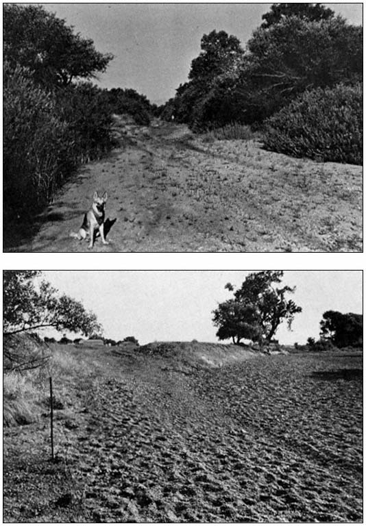
For non-tidal waters, the jurisdiction extends to the ordinary high-water mark, which is defined as:
'The ordinary high water mark' on non-tidal rivers is the line on the shore established by the fluctuations of water and indicated by physical characteristics such as a clear, natural line impressed on the bank; shelving; changes in the character of soil; destruction of terrestrial vegetation; the presence of litter or debris; or other appropriate means that consider the characteristics of the surrounding areas. (33 CFR Section 329.11[l])
It is also stated that private ownership of a river- or lakebed "has no bearing on the existence or extent of the dominant Federal jurisdiction over a navigable waterbody."
The shoreward limit of jurisdiction in coastal areas "extends to the line on the shore reached by the plane of the mean (average) high water," which, if possible, should be based upon 18.6 years of tidal measurements to account for the precession of the moon's orbit in relation to that of the sun.[46] In bays and estuaries, the CE jurisdiction:
. . . extends to the entire surface and bed of all waterbodies subject to tidal action. Jurisdiction thus extends to the edge [as determined by 33 CFR Section 329.12(a)(2) above] of all such waterbodies, even though portions of the waterbody may be extremely shallow, or obstructed by shoals, vegetation, or other barriers. Marshlands are thus considered 'navigable in law,' but only so far as the area is subject to inun-
[45] These rulings have been described frequently (e.g., Barker 1976; Leighty 1970).
[46] 33 CFR Section 329.12(a)(2).
dation by the mean high waters . . . . (33 CFR Section 329.12[b])
The 1972 definition (as amended in 1977) thus includes many areas that had not been specified in prior definitions. Jurisdiction over the "entire surface" of a waterway arose from the 1961 Supreme Court decision in U.S . v. Virginia Electric and Power Co .,[47] which in turn cited other cases to the same effect.
During the 1969 Reuss Subcommittee hearings on San Francisco Bay (Appendix A [1]), Brig. General William M. Glasgow, Jr. testified that "the Corps has exercised jurisdiction in the Bay based upon long-established mean higher high waterlines," and that "the levees constructed by Leslie Salt Co. are shoreward of such lines and no permits were therefore necessary." In 1970, objections were made on factual grounds to Glasgow's remark that the mean higher high water (MHHW) lines were "long established"; it was thus suggested that the CE did not know the true extent of its jurisdiction in present and former bay tidal marshlands (see Appendix A [15]). After considerable debate, the San Francisco District, CE, issued Public Notice No. 71-22(a) in January 1972 stating that under the 1899 Act: "Permits are required for all new work in unfilled portions of the interior of diked areas below former mean higher high water."
As a result, a sizeable but unknown fraction of the historic 313 sq. mi. of San Francisco-Suisun Bay marshlands (Nichols and Wright 1971) was clearly placed under Section 10 protection. Because Leslie Salt claimed about 70 sq. mi. of these lands, it was directly affected by the CE action and, on 20 December, 1973, filed suit against the CE, arguing that CE jurisdiction was restricted in both Sections 10 and 404 to the mean high water (MHW) line. It should be noted that Pacific Coast tides are of the "mixed" type in which the two daily high tides usually differ considerably in height. MHHW is the average of the higher of the two daily high tides, while MHW is the average of all high tides. In San Francisco Bay, MHHW is only 7 in. higher than MHW.
District Court Judge William T. Sweigert disagreed with Leslie's contention and set former MHHW as the jurisdictional limit under Sections 10 and 404.[48] On appeal, the 9th Circuit panel partially reversed Sweigert, ruling that the 1899 Act jurisdiction "extend(s) to all places covered by the ebb and flow of the tide to the mean high water (MHW) mark in its unobstructed natural state," and that under Section 404 the jurisdiction is not limited to either MHW or MHHW.[49]
Tidal Phenomena
Anyone involved in coastal and estuary studies needs a good understanding of both the theoretical and practical aspects of tides. For the most part, the theoretical knowledge needed involves an elementary understanding of astronomy and the methods of computation of simple averages in order to establish "mean high water" and other tidal datums (Marmer 1951; Schureman 1949). It is also useful to understand the methods used for obtaining these datums accurately from short series of measurements (Swanson 1974).
In addition to average values, other statistical properties of tides are increasingly being recognized as important in many scientific and engineering pursuits in the shorezone. The frequency and height of extreme high tides control the design of flood control structures and are critical in determining the dividing line between upland and aquatic vegetation. At elevations below these extreme high tides, the frequency of inundation by tide waters is an important factor in the survival and propagation of aquatic flora and fauna, and many opportunities exist for new multi-disciplinary research that joins land surveying techniques, tidal statistics, and biology (Hinde 1954; Cameron 1972; Silva 1979).
A statistical analysis of 19 years of predicted high and low tides for 55 stations on all United States coasts including Alaska and Hawaii has been prepared by Harris (1981). Tabular entries and graphs given in this work indicate the probability that tides higher (or lower) than a given level will occur, and also provide the frequencies of high and low tides within small elements of elevation. Figure 1 was prepared using Harris' results and shows the probability densities for high and low tides as functions of tidal elevation for the Golden Gate, San Francisco Bay. It can be seen that high tides range in elevation from about 0.2 ft. above mean sea level (MSL) to nearly 4.0 ft. above MSL. The probability density for high tides has a standard deviation s = 0.74 ft., resembles a gaussian error curve with that value of s , and is nearly symmetrical about mean high water (MHW). Some 97% of all high tides fall within the height range from 2s above MHW to 2s below MHW.
Also shown in figure 1 is a curve giving the average number of hours of submergence per solar day as a function of tide height. The curve shows an average submergence of about 65 minutes at the elevation of MHHW, and about 2 hours 45 minutes at the elevation of MHW.
As noted above, the jurisdiction of the CE under the 1899 Act has been restricted on the West Coast to the MHW mark in its "natural, unobstructed state." This same mark is also the limit of state sovereign land title claims (Stevens 1980; Taylor 1972). Yet it is clear that for a symmetrical high water probability density function, 50% of all high tides are above MHW, while the other 50% fall below it. This means
[47] 365 U.S. 624 (1961).
[48] Sierra Club v Leslie Salt Co . and Leslie Salt Co . v Froehlke . 412 F. Supp. 1096 (1976).
[49] Leslie Salt Co . v Foehlke and Sierra Club v Leslie Salt Co . 578 F. 2d 742 (1978).
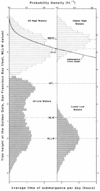
Figure 1.
Statistics of predicted tides for the Golden
Gate, San Francisco Bay, for the 19-year
period: 1963–1981. (Source: Harris 1981.)
that the lands above MHW that are inundated by one-half of all high tides do not receive protection under the 1899 Act or under state sovereign claims, even though these lands are of great importance in marine engineering, flood control, and the general biological health and productivity of an estuary. Fortunately, Section 404 provides regulatory protection for such areas, but only if they satisfy wetlands criteria spelled out in CE and Environmental Protection Agency (EPA) regulations and guidelines.
Finally, a few remarks are in order concerning the natural role of tidal flooding of saltmarsh and other estuarine areas in maintaining navigation channels and reducing the need for maintenance dredging. In 1860, Henry Mitchell, Chief in Physical Hydrography of the U.S. Coast Survey summarized his own studies with the carefully worded statement:
GENERAL RULE. A river having a bar at its mouth will be injured as a pathway for navigation if the tidal influx is reduced by encroachments upon its basins.[50]
This General Rule makes a direct connection between the goals of estuarine wetlands protection and restoration with the needs of navigation. This basic principle is familiar to students of historic works dealing with harbor design, but is seldom discussed in modern harbor engineering texts and reference works; primarily because harbor water depths needed by increased sizes of freighters and tankships over recent decades can generally be met only by instituting major dredging projects. However, application of Mitchell's General Rule as a guide can spell the difference between high and low maintenance dredging costs for flood channels and small craft harbors.
Conclusion
The flow of events—legislative and judicial—leading to the Section 404 wetlands protections has been dramatic, to say the least (see e.g., Kramer 1983). The 1976–77 Congressional debate over the Breaux and Wright amendments to Section 404 (authored by Representatives John Breaux [D-La.] and James C. Wright, Jr. [D-Tex.]) commenced quietly in a House Committee meeting on 13 April, 1976 and rose to a crescendo of head-on confrontations during Senate and conference committee meetings and floor actions lasting well into 1977, when amendments to the Clean Water Act were finally approved.
At the 13 April meeting, Breaux's short (115 word) amendment was adopted on a 22-13 vote of the House Public Works and Transportation Committee, with no input whatsoever from DI, EPA, CE, or the public. Breaux's language would have added two subsections to Section 404:[51]
[50] Mitchell, H. On the reclamation of tidelands and its relation to navigation. Appendix No. 5, Report of the Superintendent, U.S. Coast Survey. House Exec. Doc. No. 206, 41st Congress, 2d Session (1869).
[51] Section 404 of the Federal Water Pollution Control Act amendments of 1972. Hearings held on 27–28 July, 1976 before the Committee on Public Works, U.S. Senate, 94th Congress, 2d Session. Cited hereafter as "404 Hearings".
(d) The term 'navigable waters' as used in this section shall mean all waters which are presently used, or are susceptible to use in their natural condition or by reasonable improvement as a means to transport interstate or foreign commerce, shoreward to their ordinary high water mark, including all waters which are subject to the ebb and flow of the tide shoreward to their mean high water mark (mean higher high water mark on the west coast).
(e) The discharge of dredged or fill material in waters other than navigable waters is not prohibited by or otherwise subject to regulation under this Act, or section 9, section 10, or section 13 of the Act of March 3, 1899.
Public rights in waterways are guaranteed by many state and federal statutes and have been the subject of judicial rulings in the highest courts of both the United States and England. These rights have other precedent through colonial charters of the original thirteen states in English Common Law, which in turn have roots in the Magna Carta of 1215 and the Pandects of Justinian (Roman Law) of far earlier vintage. Subsection (d) of the Breaux amendment curiously tries to replace several hundred years of ruling and precedent by a definition of "navigable waters" merely 76 words long, omits "waters that have been used in the past" for navigation, and omits noting that such waters are to be taken up to the head of navigation. Under Section 404, the Breaux amendment also eliminates vast acreages of adjacent wetlands, vernal pools, prairie potholes, and other vital wetlands from protection. Indeed, one agency in 1976 estimated that only 10 million acres of the 70 million wetland acres remaining in the contiguous 48 states would still be protected. The remaining 60 million acres would be left with no significant federal protection.
Breaux's language was adopted by Representative Wright, and the resulting Wright-Breaux amendment was passed by the full House on 3 June, 1976, after a short, heated debate, on a 234 to 121 vote.
Nearly two months were to pass after the House approval before any public hearings were held on the matter. In two evening sessions on 27–28 July, 1976, the Wright-Breaux language was considered as an amendment to S. 2710 (Hart) by the Senate Committee on Public Works, chaired by Senator Jennings Randolph. The hearings stimulated a massive outpouring of views that led to a 794-page report by the committee.[51] A full description of the testimony presented is far beyond the scope of this review, but supporters of Wright-Breaux included the National Governors Conference and private interest groups associated with coal and other mining, highway construction, forest harvesting, real estate, farming, livestock, reclamation districts, and residential and commercial builders. Opposed to Wright-Breaux were groups and individuals interested in the general environment, sports and commercial fishing, and state and federal wildlife agencies.
Of more than passing interest is the testimony of Peter R. Taft, Assistant U.S. Attorney General, Land and Natural Resources Division. Taft testified that it had been frequently alleged that the CE 404 permit program is "a creation of the courts rather than Congress and transcend(s) the constitutional basis for regulation in navigable waters." Taft sharply claimed this allegation is in error, and in support of his claim provided a brief but pointed history of the public's rights in waterways and of efforts in the United States to halt water pollution, starting with Magna Carta and tracing both the legislative and judicial histories of these concepts in the United States.
Citing a number of examples in the nation, Taft also remarked:
. . . a number of the cases referred to the Justice Department for litigation have involved entities and individuals exhibiting as many characteristics of greed, fraud and outright criminality as I have ever seen in the business world. The worst have involved land developers drawn by the smell of cheap land that can be dredged and filled, often with canals, then subdivided and sold with heavy sales pitches for large front-end profits. Many of them are thinly financed. Most attempt to complete the dredging and make sales before the Corps finds out about the project; they then attempt to avoid restoration of the wetlands on the ground that they will go bankrupt and that innocent purchasers would be stuck with submerged lands they can't use.[51]
Even though the Wright-Breaux amendment was finally defeated in the Senate in 1977, bills with the same thrust have appeared frequently since then. Language identical or substantially similar to Breaux's can be found in the 1980 bills; S. 2970 (Tower), H.R. 7250 (Paul), and others pending before Congress at the time of this writing: S. 777 (Tower and Bentsen), H.R. 3083 (Hall).
The CE permit system has also been weakened in other ways. For example, the 1967 Memorandum of Understanding, referred to above, required "elevation" to Washington for settlement of unresolved differences between local officials of the CE and FWS regarding wildlife impacts of proposed projects. This memorandum was "terminated" on 24 March, 1980 when new language was adopted.[52] On 2 July, 1982 Interior Secretary James
[52] Federal Register 45:62768-71 (September 19, 1980).
Watt and others approved yet other language that allows the Assistant Secretary of the Army (Civil Works) to refuse review of contested permits by Washington officials.[53]
In addition, the definition of "fill material" under Section 404 was changed by the CE in 1977 so that it "does not include any pollutant discharged into water primarily to dispose of waste . . ."[54] This means that garbage disposal in the nation's waters or wetlands is exempt from CE environmental review under Section 404 and requires instead a NPDES (National Pollutant Discharge Elimination System) permit under Section 402 of the Clean Water Act. As a result of this loophole, new garbage dumps are today being created or expanded in diked wetlands of San Francisco Bay, despite the strong admonition by the Reuss Subcommittee in 1970 that "use of the Bay as a refuse dump is inimical to the national policy of preventing the destruction of our estuaries and must be stopped."[55]
Recent developments herald that a new round in the wetlands battle over both Section 10 and 404 has already begun (Mosher 1982). During 1976 and the preceding decade, progress in the development of wetlands protective laws and court rulings—and the defense of them against attack—occurred during both Republican and Democratic administrations, while Presidents Johnson, Nixon, Ford, and Carter served in office; administration support of wetlands protection was the rule during that era. Numerous research investigations conducted during those years also provided a sound scientific, engineering and economic basis that justifies protection of wetlands as a resource of nationwide importance. This factual material coupled with long-term political and judicial support has given great credence to the proposition that the protection of wetlands is a national goal, and clearly in the public interest.
But times have changed, for we now see the administration apparently operating in concert with a substantial Congressional power block bent upon reversing the wetlands protections gained over the past 15 years. Thus stripped to the core, wetlands defense will have to increasingly rely upon informed public opinion.
Literature Cited
Barker, Neil. 1976. Sections 9 and 10 of the Rivers and Harbors Act of 1899: potent tools for environmental protection. Ecol. Law Q. 6:109–159.
Cameron, G.N. 1972. Analysis of insect trophic diversity in two salt marsh communities. Ecology 53:58–73.
Carter, L.J. 1976. Wetlands: denial of Marco permits fails to resolve dilemma. Science 192:641–644.
Dolezel, J.N., and B.N. Warren. 1971. Saving San Francisco Bay: a case study of environmental legislation. Stanford Law Rev. 23: 349.
Harris, D.L. 1981. Tides and tidal datums in the United States. Spec. Rept. No. 7, U.S. Army Corps of Engineers, Coastal Research Engineering Center, Fort Belvoir, Va. 382 p.
Hinde, H.P. 1954. Vertical distribution of salt marsh phanerogams in relation to tide levels. Ecol. Mono. 24:209–225.
Kramer, J.R. 1983. Is there a national interest in wetlands: the Section 404 experience. In : R.E. Warner and K.M. Hendrix (ed.). California Riparian Systems. [University of California, Davis, September 17–19, 1981.] University of California Press, Berkeley.
Leighty, L.L. 1970. The source and scope of public and private rights in navigable waters. Land and Water Law Review 5:391–440.
Marmer, H.A. (ed.). 1951. Tidal datum planes (revised). Special Pub. No. 135, U.S. Coast and Geodetic Survey. U.S. Government Printing Office, Washington, D.C. 142 p.
Mosher, L. 1982. When is a prairie pothole a wetland? When federal regulators get busy. National Journal 14(10):410–414.
Nichols, D.R., and N.A. Wright. 1971. Preliminary map of historic margins of marshland, San Francisco Bay, California. Open file map, USDI Geological Survey, Menlo Park.
Sax, Joseph. 1971. A little sturm and drang at Hunting Creek. Esquire Magazine. February, 1971.
Schureman, P. 1949. Tide and current glossary (revised 1975). Special Pub. No. 228, National Ocean Survey/NOAA. U.S. Government Printing Office, Washington, D.C. 25 p.
Shalowitz, A.L. 1964. Shore and sea boundaries. Vol. 2. Pub. 10-1, U.S. Coast and Geodetic Survey, Government Printing Office, Washington. D.C. 749 p.
[53] Unpublished Memorandum of Agreement between the Department of the Interior and the Department of the Army. Dated July 2, 1982, and signed by Secretary of the Interior James G. Watt; Secretary of the Army John O. Marsh, Jr.; Assistant Secretary of the Army (Civil Works) Wm. R. Gianelli; Assistant Secretary of the Interior (Fish and Wildlife and Parks) G. Ray Arnett; and USDI Fish and Wildlife Service Director Robert A. Jantzen.
[54] 33 CFR Section 323.2(m); (1980 Ed.). First published in the Federal Register 42:37144 etseg (July 19, 1977).
[55] Appendix A (11).
Silva, P.C. 1979. The benthic algal flora of central San Francisco Bay. In : T.J. Conomos (ed.). 493 p. San Francisco Bay: the urbanized estuary. Pacific Division, American Association for the Advancement of Sciences, San Francisco, Calif.
Stevens, J. 1980. The public trust: a sovereign's ancient prerogative becomes the people's environmental right. UCD Law Rev. 14: 195–209.
Swanson, L.R. 1974. Variability of tidal datums and accuracy in determining datums from short series of observations. NOAA Technical Report NOS 64, National Ocean Survey/NOAA, U.S. Government Printing Office, Washington, D.C. 41 p.
Taylor, N.G. 1972. Patented tidelands: a naked fee? Calif. State Bar J. 47:420.
Appendix A
The following is a list of the hearings and reports of the Committee on Government Operations, Conservation and Natural Resources Subcommittee, U.S. House of Representatives, Representative Henry S. Reuss, Chairman.
Hearings
1. The nation's estuaries: San Francisco Bay and Delta, Calif. Part 1: 15 May, 1969, Part 2: 20–21 August, 1969.
2. Protecting America's estuaries: The Potomac. 21–22 July, 1970.
3. The establishment of a national industrial wastes inventory. 17 September, 1970.
4. Refuse Act permit program. 18–19 February, 1971. Senate Commerce Committee with participation by the Reuss Subcommittee.
5. Stream channelization. Parts 1–4: 3–4 May, 3–4, 9, 10, and 14 June, 1971; Part 5: 20 March, 1973.
6. Public access to reservoirs to meet growing recreation demands. 15 June, 1971.
7. Mercury pollution and enforcement of the Refuse Act of 1899. Parts 1 and 2: 1 July, 21 October, and 5 November, 1971.
8. Protecting the nation's estuaries: Puget Sound and the Straits of Georgia and Juan de Fuca. 10–11 December, 1971.
9. Protecting America's estuaries: Florida. Parts 1 and 2: 25–26 May, 1973.
Reports
10. Our waters and wetlands: How the Corps of Engineers can help prevent their destruction and pollution. House Report 91–917, March 18, 1970.
11. Protecting America's estuaries: The San Francisco Bay and Delta. House Report 91–1433, August 19, 1970.
12. Qui tam actions and the 1899 Refuse Act: Citizen lawsuits against polluters of the nation's waterways. Committee print, September, 1970.
13. Protecting America's estuaries: The Potomac. House Report 91–1761, December 16, 1970.
14. Public access to reservoirs to meet growing recreation demands. House Report 92–586, October 21, 1971.
15. Increasing protection for our waters, wetlands, and shorelines: The Corps of Engineers. House Report 92–1323, August 10, 1972.
16. Enforcement of the 1899 Refuse Act. House Report 92–1333, August 14, 1972.
17. Protecting America's estuaries: Puget Sound and the Straits of Georgia and Juan de Fuca. House Report 92–1401, September 18, 1972.
Vegetation of the Santa Ana River and Some Flood Control Implications[1]
Ted L. Hanes[2]
Abstract.—The Santa Ana River is the largest drainage system within southern California. Vegetation ranges from alluvial scrub to riparian woodland. The largest willow woodland in southern California occurs in the Prado Dam basin. Composition of vegetation-types and dynamics of vegetation in relation to flooding are discussed. Plans to alter the upper Santa Ana River are evaluated in relation to the existing and future vegetation.
Introduction
The Santa Ana River is the largest river within southern California. Its watershed covers an area of 6,263 sq. km. (2,418 sq. mi.) from the San Antonio River on the west to the San Jacinto River on the east. Most of the watershed is mountainous or hilly (3,838 sq. km. [1,482 sq. mi.]) with the remaining area being mesas and flat valleys (fig. 1).
The Santa Ana River originates in montane forests above 3,050 m. (10,000 ft.) elevation and terminates in a salt marsh at sea level, where it empties into the Pacific Ocean. Discharges average 322,000 acre-feet (AF) per year, although most of this flow is below ground except during rainstorms. Periodically the Santa Ana River experiences major flooding. During the record flood of 2 March, 1938, the Santa Ana River carried more than one AF per second as it emerged from the mountains. As a consequence, extensive stream channel alteration has been carried out in the lower half of the river below Prado Dam, built in 1941 at the head of Santa Ana Canyon. Current US Army Corps of Engineers (CE) proposals include expansion of the Prado basin by raising Prado Dam and construction of a new flood control dam at Mentone to lessen the impact of an anticipated 100-year storm.
CE alternative 5 calls for raising Prado Dam 13-m. (43-ft.) and the spillway 10.4-m. (34-ft.). The existing reservoir would be increased in size by 2,034 ha. (5,025 ac.), and 592 ha. (1,461 ac.) would be acquired below the dam in the Santa Ana Canyon to serve as floodplain lands. Alternative 6 calls for the construction of Mentone Dam to control storm runoff from a 673-sq. km. (260-sq. mi.) area. The dam and reservoir area would require 1,376 ha. (3,400 ac.) of land. Prado Dam would be raised 9.1-m. (30-ft.) and the spillway 6-m. (20-ft.). An additional 591 ha. (1,460 ac.) of land would be acquired in the Santa Ana Canyon to serve as floodplain lands.
The vegetation considered in this paper is that located in the reach between Mentone at the foot of the San Bernardino Mountains through the Santa Ana Canyon.
Literature Review
The only published description of the Mentone vegetation is by Ingles (1929). He recognized several plant associations: cottonwood/willow, Salvia /Artemisia , Adenostoma /Ceanothus and Lepidospartum /Croton . In the 1920s, the cottonwood/willow association was found throughout the wash area west of Orange Avenue and included alders (Alnus ). This entire association has since been destroyed by the establishment of rock quarries and other urban activities. Ingles considered the Adenostoma /Ceanothus and the Salvia /Artemisia association climax vegetation-types, but proposed that the cottonwood/willow and Lepidospartum /Croton associations be considered seral (successional). He acknowledged that boundaries of these plant assemblages were not well defined.
The splitting of vegetation into numerous small associations and societies in vogue in the 1920s has been replaced by the practice of designations based upon major plant groupings. Recent studies on alluvial fans in southern California designate the vegetation as alluvial scrub (Andrews 1972; Smith 1978). Smith considered the Lepidospartum /Eriogonum to be a pioneer asso-
[1] Paper presented at the California Riparian Systems Conference. [University of California, Davis, September 17–19, 1981].
[2] Ted L. Hanes is Professor of Biology and Director of the Fullerton Arboretum, California State University, Fullerton.
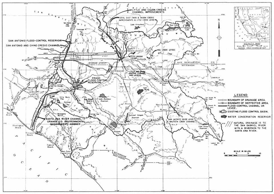
Figure 1.
Santa Ana River, California, largest river system within southern California, showing the 8,100-ha. (200,000-ac.) watershed.
Existing flood control improvements are shown. (Source: US Army Corps of Engineers, Los Angeles District.)
ciation and combined numerous half-shrubs and woody sclerophylls into a mature grouping. The fact that the alluvial vegetation contains components of coastal sage scrub (Kirkpatrick and Hutchinson 1977; Mooney 1977) and chaparral (Cooper 1922, Hanes 1976) as well as some plants of the transmontane juniper woodland make the alluvial scrub a unique vegetation-type, difficult to define or describe in ecological terms.
Less definitive treatments of the plant life of the Santa Ana River reach from Mentone to the Prado basin have been prepared. Several natural history guides are helpful, but do not provide any quantitative information (Anderson 1972a; Louis Rubidoux Nature Center 1975; Munns 1977; Riverside County Parks Dept, undated; Tri-County Conservation League 1972). The CE included some information on plant associations and plant species in its draft and final Environmental Impact Statements (US Army Corps of Engineers 1975, 1977).
The existing literature describing the flora of the Santa Ana River through Riverside, Rubidoux, Norco, the Prado basin, and Santa Ana Canyon is generally limited and sketchy in nature. Anderson (1972b) presented a brief account of human impact on the Santa Ana River starting with aboriginal influences. The first vegetation study (Howell 1929) described the woodland in its near-pristine condition. Wieslander (1934) published a detailed vegetation map of the Corona. quadrangle showing the Santa Ana River and Chino Creek as naturally wooded areas in the vicinity of what is presently the Prado basin. Little (1979) concluded that the construction of Prado Dam in 1941 did not create an artificial willow/cottonwood woodland, but simply expanded its previous boundaries by raising and extending the water table. Hanes (1980) presented the first quantitative analysis of the vegetation in the Santa Ana Canyon area.
The riparian woodland in the 6,480-ha. (16,000-ac.) Prado basin is a cottonwood/willow forest-type (Society of American Foresters 1954). Several plant lists have been prepared for the Prado basin (Howell 1929; Marsh and Abbott 1972; URS Research Company 1974). Little (1979) conducted field studies in the Prado basin and combined his findings with previous lists. The combined list contained 232 plant species belonging to 5 families of vascular plants. Of the total, 156 species (67%) were native (indigenous) and 73 (31.5%) were non-native (introduced, exotic). Little (ibid .) speculated that the Santa Ana River should have many rare and endangered species.
Hanes (1980) conducted a study from Mentone to the Santa Ana Canyon during the spring of 1980 and reported 65 families of vascular plants which included 428 species. Of these, 330 (77%) were native and 98 (23%) were non-native species.
Methods
The Mentone vegetation was sampled extensively using the line-intercept method. Base lines were established every 50–100 m. in major sectors of the alluvial fan. At intervals of 20 m., a 10-m. intercept transect line was placed at right angles to the base line. One transect line was laid to the right and the next line to the left in alternating fashion. The crowns of all perennial shrubs that overlapped or intercepted the transect line were recorded by species, to the nearest 5 cm. crown length. This rapid technique is considered the most efficient and accurate method of sampling full-crowned shrubs (MuellerDombois and Ellenberg 1974). The accumulated length occupied by any one species out of the total transect line length used for the sample was expressed as the percent cover for that species.
Riparian woodland vegetation was sampled using 3.3- × 30-m. continuous transects placed at random throughout the woodland stands between Riverside and the Santa Ana Canyon. Trees were recorded by species as alive or dead. Their estimated trunk diameters at breast height (DBH) were placed in one of the following size-classes: 2–6, in., 7–12 in., 13–24 in., 25–48 in. The enumeration of trees by species within the 3.3- × 30-m. plots allowed the calculation of tree density; i.e., the number of each species per unit area (ibid .).
Herbaceous plants were sampled using a 1- × 1-m. quadrat subdivided into 100-dm. squares. Only percent cover by species was determined since individuals in many cases were impossible to determine. Furthermore, percent cover gives a better measure of plant bulk (biomass) than does the number of stems or individuals (ibid .).
Three parameters of vegetation were assessed. These were density (number of plants of a species per plot), cover (size of crown of the plant), and frequency (number of subplots in which a species occurs). Importance value (IV) is a composite of these three vegetation parameters. It was determined by summing the relative density, relative cover, and relative frequency of a species. Relative values for each species were obtained by dividing each vegetation by the total of all species.
Vegetation Structure and Floristics
Mentone
Four vegetation-types were recognized on the Mentone alluvial fan. The most extensive vegetation-type was juniper woodland. A total of 327 line intercepts were established in the woodlands east of Orange Avenue. Juniper (Juniperuscalifornica ), by virtue of its size, dominated the vegetation, but smaller shrubs such as Eriogonumfasciculatum , Eriodictyontrichocalyx , Opuntialittoralis , and Gutierrezia sp. were important in terms of percent cover, percent density, and percent frequency. Thirty-two additional shrub species were found in the woodland. Over 43% of the Eriogonum was dead, even though the species had the highest importance value (IV). This was true of the other dominant species except Juniper, which had the lowest dead IV.
The juniper woodland west of Orange Avenue was sampled to compare it with the more extensive woodland east of Orange Avenue. Here the woodland was similar to that east of Orange Avenue in perennial shrub composition and structure, but the IVs were generally lower. This was due in part to the area being used extensively as an unauthorized dump; and perhaps the groundwater supply is lower since it lies between the Santa Ana River and Plunge Creek and the normal drainages from the east have been blocked by Orange Avenue.
Alluvial scrub occupied the younger frequently disturbed sites. This vegetation-type was also dominated by Eriogonum fasciculatum , which had an IV greater than any other shrub species. Other dominant but less frequent shrubs were Adenostomafasciculatum , Eriodictyon trichocalyx , Lotusscoparius , Artemisiacalifornica , and Rhusovata . Only 17 shrub species comprised the alluvial shrub vegetation.
The riparian woodland found on the Mentone alluvial fan was poorly developed and a minor component of the vegetation. It was dominated by California sycamore (Platanusracemosa ), but these were small, drought-stunted trees that hardly formed a woodland. Other tree species, such as willow or cottonwood, were found only rarely. More commonly, shrubs such as Eriogonumfasciculatum , Yuccawhipplei , and Opuntialittoralis , were associated with the sycamore trees along old, as well as active, watercourses.
Herbaceous plants were abundant in the juniper woodlands. The average number of plants was 62 per sq. dm. in the woodland east of Orange Avenue, and 26 per sq. dm. in the woodland west of Orange Avenue. The species number was also higher east of Orange Avenue (25); west of Orange Avenue it was only 18.
Riverside to Norco Reach
Extensive riparian woodlands occur in the Riverside-Norco reach of the Santa Ana River. Gallery cottonwood forests are found in the Riverside-Rubidoux reach. Nearly continuous young riparian woodlands are found in the Rubidoux-Norco reach. These were sampled but the data are not presented in this paper.
Prado Basin
Due to the major flooding of the Prado flood basin during February 1980, a quantitative vegetation analysis could not be performed at the time of the field study.
Qualitative assessments by direct observation from viewing points and other places around the basin perimeter are presented here. About 80% of the Prado basin was covered by extensive areas of riparian woodland, dominated by dense stands of arroyo willow (Salixlasiolepis ), black willow (Salix gooddingii ), and Fremont cottonwood (Populus fremontii ). Other woodland trees dominant by size but scattered in distribution were California sycamore, black cottonwood (Populustrichocarpa ), red willow (Salixlaevigata var. araquipa ), and golden willow (Salixlasiandra ).
The riparian woodland trees in the basin had withstood more than 12 weeks of inundation during their dormant (deciduous) stage without apparent ill-effects. While standing in water these trees were developing a full crop of leaves, flowering, and bearing fruit. The trees showing this amazing adaptation to flooding were the willows, cottonwood, and sycamore. Furthermore, fallen trees, broken limbs, and other tree parts left by the eroding action of floodwaters were actively taking root and sprouting vigorously where floodwaters had receded.
Santa Ana Canyon
The vegetation in the upper end of the Santa Ana Canyon was mainly gallery-type riparian woodland. A major stand grew between Prado Dam and the golf course. A second woodland dominated the Featherly Park area. Some isolated riparian shrubs and perennial herbs occurred between Featherly Park and Imperial Boulevard, but in this reach the riverbed was composed of recently deposited sand and other alluvia with limited vegetation.
The woodland composition below Prado Dam is shown in table 1. Willows dominated (91% of the stands); these trees were in the 2–6 in. DBH size-class. Less than 10% of the woodland was composed of Fremont cottonwood; like the willows the majority had small trunks. About 29% of the woodland trees were in the size-class 7–12 in. DBH. The willow density was 1,250 per ha. (506 per ac.) whereas the cottonwood density was 114 per ha. (46 per ac.). Of the trees present, about 20% were dead, standing or fallen. In the woodland below the dam some riparian shrubs such
| ||||||||||||||||||||||||||||||||||||||||||||||||||||||||||||||||||||||||||||||||||||||||||||||||||||||||||||||||
as shrub willows and mulefat (Baccharisglutinosa ) formed a broken understory. However, these shrubs were found mainly on the woodland margins and were not sampled. Due to the heavy flooding of this woodland stand, the soil surface was either washed or covered with sand and silt deposits to various depths ranging up to 40.6 cm. (16 in.). Little or no herbaceous growth had become established on these recent deposits.
The woodlands in the Featherly Park reach also had considerable shrub understory, making access very difficult. The understory was composed of seedlings of willow with trunks less than 2 in. in diameter and mulefat. The understory was further complicated by dense root sprouts from downed willows and clumps of giant reed (Arundodonax ). Natural breaks in the woodland occurred randomly and represented past flooding events of erosion or deposition. These sites were filled with dense stands of mulefat. Over a period of time these shrub areas may succeed to woodlands.
Impacts of Proposed Flood Control Projects
Construction of Mentone Dam and Reservoir and the realignment of Mill Creek and levee, as proposed by the CE, would have a major impact on the existing vegetation. The borrow pit would destroy over 200 ha. (500 ac.) of native juniper woodland and alluvial scrub vegetation. This would be a significant loss since the Mentone alluvial fan vegetation represents the largest stand of California juniper on the coastal side of the Transverse Ranges in southern California. Further, urban pressures elsewhere have reduced, altered, or destroyed the vegetation on other alluvial fans in coastal southern California. The presence of species such as Lepidospartumsquamatum , unique to alluvial fans and washes, and the mixture of coastal sage scrub with chaparral species makes the vegetation unique to southern California. The springtime meadowland created by numerous species of herbaceous plants would be destroyed by inundation. This component of the vegetation is a carpet of herbaceous, annual flowering plants, between the shrubs, that flourishes during the sring months and then dies off with the onset of summer.
The existing percolation basins clearly indicate that junipers, all herbaceous plants, and many of the perennial plants that make up the alluvial scrub vegetation could not tolerate inundation. Plants remaining after grading operations are completed and the dam is operational would be killed if exposed to short episodes of inundation. The proposed recreational area of 121 ha. (300 ac.) would lie partially below the take line and would be subject to infrequent inundation episodes. If the Mentone Dam is constructed, sycamore, other riparian trees, shrubs adapted to the alluvial environment, and shrubs that can withstand inundation should be planted instead of inundation-intolerant species.
Human activity in the remaining natural and recreation areas would not greatly affect the perennial vegetation. However, foot traffic and other uses would have an impact on the annual herbaceous cover.
Within the Prado basin, the impact of flooding on the woodland trees seems minimal. To date they have been able to withstand at least three months of inundation without apparent damage. Whether they can continue to do so is unknown. The riparian shrubs can survive shorter periods of inundation, perhaps several weeks. Herbaceous vegetation and most agricultural crops would be affected by flooding, erosion, siltation, and inundation. The higher the frequency of inundation the greater the impact on herbaceous plants.
If material is taken from the basin for the construction of Mentone Dam, several hundred acres of riparian woodland will be destroyed. The borrow pit may be turned into four small lakes or one large lake for recreational purposes. If shoreline grading is required, this would further destroy riparian woodland vegetation. Small trees replanted to replace mature trees are not equivalent in stature, aesthetics, wildlife habitat value, or time.
Below Prado Dam the impacts of CE alternates 5 and 6 would result from the infrequent releases of volumes of water up to five times that of present release rates. Such high volumes would have major impacts on the riparian woodlands. All types of plants, even mature trees, would suffer from the erosive action and sheer weight and velocity of the water. Existing small channels and riverbanks would be altered or destroyed. Within the more stable woodlands, herbs, shrubs, tree seedlings, and downed dead wood would be swept away. As trees were dislodged and swept downstream, they would become obstructions in the main river channel. Ultimately, they would be swept out to sea.
The above impacts would be accentuated if more water was retained in the basin, since less water would be released in minor storms than at present. This would allow more trees, shrubs, herbs, and other understory plants to establish themselves in the main river channels before they were exposed to the impact of a major release of water. More frequent but less intense flooding would keep the woodland vegetation in a more juvenile stage of develoment; consequently it would show less impact from a major water release.
Mitigation
1. The loss of prime juniper woodland could be partially mitigated by acquiring the woodland west of Orange Avenue. Although it lacks the richness of that east of Orange Avenue, it does possess the same structure and general physiognomy. This acquisition would insure that this woodland would not be lost to urbanization.
2. Wherever suitable, plantings of groundcover, shrubs, and trees that are native and otherwise adapted to the site should be used. The present species could be augmented with such species as Alnusrhombifolia , Salix sp., and shrubs found on other alluvial fans in southern California.
3. All plantings around the proposed lake(s) should be species known to be able to withstand the riparian conditions of wet soil, flooding, and inundation.
4. Certain native riparian plants could be introduced to augment the species present. Alnusrhombifolia , Acermacrophyllum , and Umbellulariacalifornica would be suitable additions.
5. Inundation episodes in the upper zones of the Prado Reservoir should not be allowed to last over three weeks, in order to avoid killing off the herbaceous understory plants and agricultural crops.
6. The projected release volumes from Prado Dam should be reduced. This would reduce the impact on the riparian woodlands below the dam and in the Featherly Park reach. Since the reach below the dam is designated as a greenbelt, the devastating effects of massive water release on the riparian woodlands should be reduced or avoided.
Literature Cited
Anderson, E.N. 1972a. Western Riverside County: a natural history guide. 33 p. Anderson Publcations, Sunnymead, Calif.
Anderson, E.N. 1972b. Man on the Santa Ana: a brief account of human management of a land. 10 p. Tri-County Conservation League, Riverside, Calif.
Andrews, P.W. 1972. Ecology of a southern California floodplain. Ph.D. Thesis, Claremont Graduate School, Claremont, Calif. 300 p.
Cooper, W.S. 1922. The broad-schlerophyll vegetation of California. An ecological study of chaparral and its related communities. 124 p. Carnegie Inst. Wash. Publ. 319, Washington, D.C.
Hanes, T.L. 1976. Vegetation types of the San Gabriel Mountains. In : Symposium proceedings: plant communities of southern California. Special Publ. Calif. Native Plant Soc., Berkeley, Calif. 164 p.
Hanes, T.L. 1980. Environmental appendix to the final Phase I general design memorandum and the final supplemental environmental impact statement—Santa Ana River main stem including Santiago Creek and Oak Street drainage. U.S. Engineer District, Los Angeles, Calif.
Howell, J.T. 1929. The flora of the Santa Ana Canyon region. Madroño 1:243–253.
Ingles, L.G. 1929. The seasonal and associational distribution of the fauna of the upper Santa Ana River Wash. J. Entomology and Zool. 21:1–45, 57–96.
Kirkpatrick, J.B., and C.F. Hutchinson. 1977. The community composition of California coastal sage scrub. Vegetatio 35(1):21–23.
Little, R.J. 1979. Floristic overview of the Prado Dam flood control basin, Part II—existing biotic environment. 5 p. Santa Ana Watershed Project Authority, by ECOS management criteria, Tustin, Calif.
Louis Rubidoux Nature Center. 1975. Plant communities of the Santa Ana River Regional Park, Rubidoux, Calif. 8 p. Riverside County, Riverside, Calif.
Marsh, G.A., and K.D. Abbott. 1972. Plants and animals of the Santa Ana River, Orange County. Orange County Flood Control District Publ. No. 27, Santa Ana, Calif. 50 p.
Mooney, H.A. 1977. Southern coastal scrub. In : M.G. Barbour and J. Major (eds.). Terrestrial vegetation of California. 1,002 p. Wiley Interscience, New York, N.Y.
Mueller-Dombois, D., and H. Ellenberg. 1974. Aims and methods of vegetation ecology. 541 p. John Wiley and Sons, New York, N.Y.
Munns, Bob. 1977. Flora of the Rubidoux Nature Center. 6 p. Natural Science Section, Angeles Chapter, Sierra Club, Los Angeles, Calif.
Riverside County Parks Dept. Undated. Willow Flats trail, nature trail guide. Prado Basin Regional Park, Norco. 5 p.
Riverside County Parks Dept. Undated. Checklist of the common plants associated with the Santa Ana River Regional Park, Riverside, Calif.
Smith, R.L. 1978. The alluvial scrub vegetation of the San Gabriel River floodplain, California. M.A. Thesis, California State University, Fullerton. 43 p.
Society of American Foresters. 1954. Forest cover types of North America. 67 p. Society of American Foresters, Washington, D. C.
Tri-County Conservation League. 1972. The living Santa Ana River. 31 p. Tri-County Conservation League, Riverside, Calif.
URS Research Company. 1974. Environmental baseline inventory of the Santa Ana River basin. 83 p. Prepared for the Santa Ana Watershed Planning Agency. Santa Ana Calif.
US Army Corps of Engineers. 1975. Draft environmental statement Santa Ana River Basin and Orange County, Los Angeles, Calif. 354 p. U.S. Army Corps of Engineers, Los Angeles, Calif.
US Army Corps of Engineers. 1977. Draft environmental statement. Review report on the Santa Ana River main stem—including Santiago Creek and Oak Street drain for flood control and allied purposes. 126 p. Office of the Chief of Engineers, Department of the Army, Washington. D.C.
Wieslander, A.E. 1934. Vegetation types of California. Corona quadrangle map. From a series of topographic botanical maps: vegetation types by California Forest and Range Experiment Station of the USDA. Forest Service Surveyed 1931 and Revised 1934.
Technical Delineation of Wetland Boundaries within California Riparian Systems[1]
Robert Terry Huffman[2]
Abstract.—Since passage of the Clean Water Act in 1972, significant emphasis has been placed on the need for technology which will enable regulatory personnel to precisely delineate jurisdiction boundaries between wetland and nonwetland ecosystems in the field. To meet this need, the US Army Corps of Engineers and the Environmental Protection Agency have jointly been conducting research directed toward the development of technical standards and field methodology. To date, these efforts have resulted in the development of technical standards and methodology which emphasize an ecosystematic approach whereby wetlands soil, hydrology, and vegetation parameters are jointly assessed when making boundary determinations. By relying on this multiple-parameter approach, the difficulty in making boundary determinations in transitional areas between wetland and upland areas has been substantially reduced. This method is in contrast to traditional techniques which emphasize the use of vegetative indicators.
Introduction
The primary legislative basis for the US Army Corps of Engineers (CE) regulatory authority in wetlands is Section 404 of the Clean Water Act. This act gives the CE and the US Environmental Protection Agency (EPA) authority to regulate discharge of dredged or fill material in "Waters of the United States". The objective of Section 404 is to maintain and restore the biological, physical, and chemical integrity of the nation's water quality through regulation of the discharge of dredged and fill materials into "Waters of the United States." "Waters of the United States" has a broad meaning, incorporating both aquatic and wetland ecosystems (Federal Register 1977). The purpose of this paper is to summarize the approach developed by the author to technically identify and delineate in the field wetland ecosystems found in association with California riparian zones.
Jurisdiction
Definition of jurisdiction in federal environmental regulatory programs has a legal basis that is the result of Congressional action. It is from this point that policy, regulations, and implementation procedures are developed by federal agencies mandated to conduct various regulatory programs.
Prior to enactment of the Clean Water Act, CE jurisdiction, under Section 10 of the Rivers and Harbors Appropriations Act of 1899, was defined as the mean high-tide line for tidal waters and ordinary high-water mark for nontidal waters, as the intent of Section 10 is to protect navigation. Reliance on the boundaries established by Section 10, therefore, proved to be of little value after the enactment of the FWPCA, given the intent of the Act, as water moves in hydrologic cycles, and pollution of this cycle at any point can affect water quality. Regulation of dredge and fill activities that cause water pollution, therefore, cannot rely on artificial boundary lines drawn for administrative purposes. Under Section 404 of the FWPCA, the intent of regulation is to focus on all "Waters of the United States" that together form the entire aquatic ecosystem (ibid .). The term "Waters of the United States" is defined to include:
a. The territorial seas with respect to the discharge of fill material.
[1] Paper presented at the California Riparian Systems Conference. [University of California, Davis, September 17–19, 1981].
[2] Robert Terry Huffman is Senior Project Scientist, Environmental Permitting and Government Relations, Woodward-Clyde Consultants, Walnut Creek, Calif.
b. Coastal and inland waters, lakes, rivers, streams that are navigable waters of the United States, including their adjacent wetlands.
c. Tributaries to navigable waters of the United States, including adjacent wetlands.
d. Interstate waters and their tributaries, including adjacent wetlands.
e. All other waters of the United States not identified above, such as isolated wetlands and lakes, intermittent streams, prairie potholes, and other waters that are not a part of a tributary system to interstate waters or navigable waters of the United States, the degradation or destruction of which could affect interstate commerce (ibid .).
Wetlands are also defined as "those areas that are inundated or saturated by surface or groundwater at a frequency and duration sufficient to support, and that under normal circumstances do support, a prevalence of vegetation typically adapted for life in saturated soil conditions" (ibid .).
These largely technical definitions are the basis from which the jurisdictional limits of Section 404 of the FWPCA must be initially determined. From this point, various exemptions, such as those for normal agricultural and silvicultural practices, come into play in deciding if an activity within the defined limits of jurisdiction would require a permit under the Section 404 regulatory program.
Although the meaning of "Waters of the United States" and wetlands appears to be clearly defined, the on-site determination of the landward limit of jurisdiction has often been difficult to make. This is especially true in areas of gradual gradation from obvious wetlands to obvious nonwetlands (i.e., uplands). These areas are typically under great demand for agricultural and urban development, yet they are vitally important for water quality maintenance and other benefits attributed to wetlands. With this emphasis in mind, it is extremely important that jurisdictional limits be determined with as much technical accuracy and consistency as possible.
Delineation of Wetland Boundaries
Much emphasis and reliance has been placed on using vegetation as indicators of wetland boundaries. This technique has often proved troublesome for riparian systems, however, especially in areas where man regulates the flow of water within the streamcourse. For example, in the Sacramento River area, management of the river's flows has occurred since the early 1940s. This condition has resulted in a significantly reduced amount of flooding in high-terrace riparian zones, to the point that saturated soil conditions during the growing season are almost non-existent. Yet vegetation cover-types in these areas largely remain representative of highterrace wetland systems. If all that was looked for by an investigator was "a prevalence of vegetation typically adapted for life in saturated soil conditions", much of the high-terrace zone along the Sacramento River would technically qualify as being wetlands.
With reference to the above definition of wetlands, two key environmental characteristics are considered essential in the technical delineation of the landward jurisdictional limit of Section 404:
1. inundated or saturated soil conditions that are the result of periodic or permanent inundation by groundwater or surface water; and
2. a prevalence of vegetation typically adapted for life in inundated or saturated soil conditions.
These characteristics are actually general guidelines or concepts rather than specific parameters necessary to identify wetlands within California riparian systems under Section 404 jurisdiction. They alone do not provide solutions to the previously mentioned problem.
It is with these concepts in mind that three distinctive parameters are suggested which, when considered together, significantly increase the investigator's ability to correctly define a wetland boundary. They include wetland hydrology, soil, and vegetation. Each parameter is dependent on the other in an environmental sense, as any one does not uniquely make a wetland. It was from this concept that the "Multiple Parameter Approach to the Field Identification and Delineation of Wetlands" (Huffman 1981) was devised. The technical standard used to define wetlands is based on the following diagnostic environmental characteristics.
1. Hydrology—the area is inundated or saturated by surface water or groundwater either permanently or periodically during the growing season of the prevalent vegetation.
2. Soils—the soils within the root zone become saturated permanently or periodically during the growing season of the prevalent vegetation.
3. Vegetation—the prevalent plant species associated with the plant community are typically adapted for life within habitats that have permanent or alternating dry and inundated and/or saturated soil conditions as characterized by the hydrology and soil conditions given above. Wetland plant species are rooted-emergent organisms that, because of morphological adaptations(s), physiological adaptations(s), and/or reproductive strategies, have the ability to achieve maturity and reproduce in an environment where anaerobic soil conditions occur within the root zone on a permanent or periodic basis during the growing season.
A wetlands determination using the multiple-parameter approach relies upon evidence of a minimum of three positive indicator variables, at least one from each of the three parameters of hydrology, soils, and vegetation, before a positive wetland determination can be made (table 1).
The approach has considerable flexibility from one region to another, as the qualitative variables used to provide positive indication of each parameter can be added or deleted when necessary, given local variations in the environment.
| |||||||||||||||||||||||||||||||||||||||||||||||||||||||||||||||||||||||||||
| ||||||||||||
| ||||||||||||
| ||||||||
Glossary
Adaptation —Response to selective pressure resulting in an organism (or group of organisms) acquiring characteristics which make the organism better suited to live and reproduce in its environment. A plant adaptation is therefore a peculiarity of morphological structure or physiology that especially aids in fitting the organism to its particular environment.
Aquatic ecosystem —Those areas that are either permanent or periodically flooded by surface water or groundwater and are unsuitable for growth of rooted-emergent vegetation.
Ecosystem —The plant community and the associated nonliving environment (chemical and physical) with which the vegetation interacts.
Flood —The condition that occurs when water overflows the natural or artificial confines of a stream or other body of water or accumulates by drainage over low-lying areas.
Groundwater —Subsurface water including the zone of aeration and zone of saturation.
Growing season —The frost-free period of the year (see US Department of the Interior [1970] for generalized regional delineation).
Habitat —The physical and chemical environment occupied by a particular plant, populations of plants, or a plant community.
Hydrology —The science dealing with the properties, distribution, and circulation of water.
Inundation —A flooded condition created by the rise and spread of surface water or groundwater over a land surface that is not permanently submerged.
Morphological —Pertaining to the structure and form of an organism at any stage of its life cycle.
Periodically —Herein defined to describe saturated soil conditions or inundation resulting from ponding from groundwater and/or rainwater, overland flow, stream flooding, or tidal action that occur(s) on a detectable regular or irregular basis with hours, days, weeks, months, or even years between events.
Physiological —Pertaining to the basic physical and chemical activities that occur in cells and tissues of organisms.
Prevalent vegetation —Herein defined for the purposes of this technical standard as the perennial plant species within all or any given vegetation strata having established relative areal cover, density, basal area, biomass, abundance, dominance value, or importance value per hectare ³ 50%.
Saturated soilcondition —Herein defined for the purposes of this technical standard as the soil within the root zone that becomes permeated with water to the extent that detectable anaerobic soil conditions occur.
Submergent plant —A vascular or nonvascular hydrophyte, either rooted or nonrooted, which lies entirely beneath the water surface, except for flowering parts in some species; e.g., wild celery (Vallisneria americana Michx) or the stoneworts (Chara spp.).
Surface water —Water above the substrate.
Typically adapted —Describing a species exhibiting the essential characteristics of a group.
Vegetation —The plant life that occupies a given area.
Conclusions
In technically defining the landward boundary of federal jurisdiction within wetland ecosystems, much emphasis has traditionally been placed by the CE as well as other federal agencies on using indicator vegetation. However, this technique has historically proven to be quite troublesome. This is because vegetation, considered alone, may both overstate and understate jurisdiction due to the often-broad genetic variability of the plant species encountered.
In contrast to the use of indicator species, wetlands determinations using the multiple parameter approach presented here rely upon evidence of a minimum of three positive indicator variables, at least one from each of the three parameters of hydrology, soils, and vegetation, before a positive wetland determination can be made. This approach has undergone considerable field testing in California and throughout the United States. Results of these tests demonstrate that the approach had considerable flexibility. When moving from one region of the country to another, the qualitative variables used to provide positive indications of each parameter can be added or deleted as necessary, given local variations in the environment. The approach also affords the user the ability to make rapid boundary determinations, thus foregoing lengthy delays while collecting quantitative data, which may take weeks, months, or even years to complete. The multi-parameter approach can also be applied during the winter season. Prior to use of the multiple parameter approach, regulatory jurisdiction determinations could only be made during the spring and summer (approximately three to four months of utility) in snowbound areas such as the Alaskan Arctic.
Training using the above described approach is currently being provided to federal, state, and local governments throughout the United States. The author is currently contemplating offering similar training to private concerns. The multi-parameter approach is easily mastered and does not require that users have an extensive technical background to become proficient in utilizing the approach.
Literature Cited
Federal Register. 1977. Title 33—navigable waters; Chapter II—Corps of Engineers, Department of the Army: regulatory programs of the Corps of Engineers. Vol. 42(138): 37122–37164 (9 July). US Government Printing Office, Washington, D. C.
Huffman, R.T. 1981. Multiple parameter approach to the technical identification and delineation of aquatic and wetland ecosystems: technical standards. US Army Engineer Waterways Experiment Station Technical Report E-81 (in press). Vicksburg, Miss.
US Department of the Interior. 1970. National Atlas 1970:110–111.
Riparian Protection from Corps of Engineers Projects[1]
Fred Kindel[2]
Abstract.—About 19,800 ha. (49,000 ac.) of riparian vegetation in California can be protected with U.S. Army Corps of Engineers projects. Public support is vital. Some examples are the New Melones Lake project 2,065 ha. (5,100 ac.); Sacramento River Bank Protection project 351 ha. (868 ac.); and Sacramento River and Tributaries Bank Protection and Erosion Control Investigation 11,740 ha. (29,000 ac.).
Introduction
This paper addresses some work of the US Army Corps of Engineers (CE) in California that has an important influence on riparian systems. It describes the protection, restoration, or improvement of riparian vegetation in connection with 13 projects and investigations in various stages of construction and planning. There are about 19,800 ha. (49,000 ac.) of riparian vegetation that have been, will be, or have the potential of being protected, restored or improved as a part of the CE work within the Sacramento District.
Completed or Nearly Completed Projects
New Melones Lake Project
The New Melones Lake Project has been a controversial and widely publicized project. New Melones Dam was completed in 1979. It is located on the Stanislaus River, in the Sierra foothills about 113 km. (70 mi.) east of Stockton (Calaveras and Tuolumne counties). Most people have probably heard the arguments regarding preservation of whitewater in the river versus flood control and development of water resources of the river. But there is a feature of this project that is less widely known—the lower Stanislaus River. The lower Stanislaus runs for about 96.6 km. (60 mi.) from Goodwin Dam, some 16 km. (10 mi.) below New Melones, to its confluence with the San Joaquin River near Caswell State Park.
The CE is acquiring interest in about 2,065 ha. (5,100 ac.) of riparian system along the lower Stanislaus River. This riparian area is needed for preservation of fish and wildlife habitat, for public recreation, and for passage of floodflows as a part of the overall project. Easements are being acquired for riparian vegetation protection and flowage; fee title is being acquired for a series of small parks for public access and recreation.
Sacramento Bank Protection Project
Another project that many may consider to be controversial is the Sacramento River Bank Protection Project. This is a joint project of the CE and the State of California, with the State paying one-third of the cost. The purpose of the project is to protect the integrity of the Sacramento River Flood Control Project—a system of levees and bypass channels which provides flood protection to about 323,900 ha. (800,000 ac.) of agricultural land and urban areas, including the city of Sacramento.
The first phase of this project was constructed between 1963 and 1974; about 130 km. (81 mi.) of levees was protected with rock bank protection. During the construction work, some riparian vegetation was removed from the levees and replaced with rock. With assistance from the USDI Fish and Wildlife Service (FWS) and agreement by the State of California to pay one-third of the added cost, the CE has prepared a feasibility report which recommends the restoration of 270 ha. (668 ac.) of riparian vegetation that was removed. If Congress authorizes and funds this work, the 270 ha. of riparian vegetation will be restored on berms adjacent to the levees at selected locations along 201 km. (125 mi.) of the Sacramento River upstream from the city of Sacramento.
A similar environmental protection and riparian vegetation restoration program was authorized by Congress in 1974 as an integral part of the next 124 km. (77 mi.) of bank protection, the second phase of the project. In conjunction with the second phase work, the State has acquired environmental easements on over 81 ha. (200 ac.) of land along the Sacramento River Flood Control Project.
[1] Paper presented at the California Riparian Systems Conference. [University of California, Davis, September 17–19, 1981].
[2] Fred Kindel is Chief, Environmental Planning Section, Sacramento District, US Army Corps of Engineers, Sacramento, Calif.
Isabella Lake
Isabella Lake is located on the Kern River east of Bakersfield (Kern County). It is a reservoir storing up to 570,000 acre-feet (AF) of water for flood control, irrigation, and hydroelectric power. The project was completed in 1953 and has been recognized as an outstanding fishing lake for many years. In recent years, the wildlife habitat of the lakeshore has been managed and improved. Particular attention has been given to some 526 ha. (1,300 ac.) of riparian vegetation located where the South Fork of the Kern River enters the lake. Protection is being provided for this particular riparian system. The National Audubon Society and other conservation organizations believe it is a significant riparian resource. This area will be discussed more fully in a following section reporting on a current investigation of the CE that may affect it.
Authorized Projects under Study
There are four projects that have been authorized for which the CE has been conducting advanced planning and design studies prior to beginning construction.
Cottonwood Creek Project
The Cottonwood Creek Project includes two large reservoirs in Shasta and Tehama counties. This project will provide an added municipal and industrial water supply. The State of California will repay about 80% of the total cost of the project to conserve and store this water. The two reservoirs will store up to 1,600,000 AF of water and will inundate about 648 ha. (1,600 ac.) of riparian vegetation. The CE, after consulting with the FWS and the California Department of Fish and Game (DFG), has developed plans to restore this riparian vegetation on other lands needed for the project. Lands are needed below the spillways for accommodation of floodwaters and below the dams for management of salmon. The 648 ha. of riparian vegetation would be restored on those lands. In addition, the CE has identified a site of about 1,215 ha. (3,000 ac.) below the dams for riparian vegetation improvement. This is an area of existing riparian vegetation which could be protected and improved to support migratory birds. The FWS has advised that they may recommend the area be purchased to support the migratory bird conservation program which they administer. The two areas together would ensure federal protection and management for about 1,862 ha. (4,600 ac.) of riparian vegetation.
Merced County Streams Project
The Merced County Streams Project includes two existing dams, two dams to be built, and 53 km. (33 mi.) of channel improvements to control flooding in urban and agricultural areas in Merced County. At this project there is a mixture of important vegetation for wildlife, including grasslands, wetlands, and riparian vegetation, that will be protected. In conjunction with the project work, protective easements will be acquired by Merced County on 1,134 ha. (2,800 ac.) of grassland, 61 ha. (150 ac.) of wetlands, and 81 ha. (200 ac.) of existing riparian vegetation. The riparian vegetation is located partially behind the two existing dams which temporarily store floodwaters and partially along the streams below the dams. The design of the flood channels includes protection and restoration of the riparian vegetation while still allowing passage of the floodwaters.
Morrison Creek Project
The Morrison Creek Project is located on the east and south sides of the city of Sacramento (Sacramento County). A small lake would be formed near Mather Air Force Base. About 306 km. (190 mi.) of channel improvements would be provided in the urbanized area south of the Sacramento Army Depot, including the communities of Florin Center and Elk Grove. At the terminus of the channels, near the Sacramento River, floodwaters would be temporarily stored in a 2,834 ha. (7,000 ac.) flood-retardation basin which is also authorized as a national wildlife refuge, to be managed by the FWS. There are about 20 ha. (50 ac.) of riparian vegetation which would be protected at the retardation basin and wildlife refuge; the remainder is wetland and grassland. Additional riparian vegetation improvement may be provided as plans for the small lake, channels, and retardation basin are developed.
Stockton Ship Channel Project
The Stockton Ship Channel Project is an authorized navigation project which will allow larger, fully loaded deep-draft ships to reach the Port of Stockton. The present channel depth is 9.1 m. (30 ft.) deep below mean lower low water. The channel will be deepened to 10.7 m. (35 ft.) to allow ships using the channel to be more fully loaded and not have to leave port only partly loaded as many do now. About 9.2 million cubic meters (12 million cubic yards) of material will be dredged from the channel and deposited at selected sites. Environmental studies have been made in an effort to minimize damage to wetlands and riparian systems along the channel. About 162 ha. (400 ac.) at two flooded islands will be filled with dredged material to create new wetlands and sites for riparian vegetation. About 24 ha. (60 ac.) of riparian vegetation is included in this plan. Since the Sacramento/San Joaquin Delta area has a relatively small amount of riparian vegetation, this will be an important addition.
Preauthorization Investigations
There are six investigations underway on possible projects having significant potentials for protecting and improving riparian vegetation.
Sacramento River and Tributaries Bank Protection and Erosion Control Investigation
This study covers 502 km. (312 mi.) of the Sacramento River from Collinsville upstream to Shasta Dam, and lower reaches of major tributaries such as the American and Feather rivers. The investigation is two-thirds complete. The major purpose of the investigation is to study alternatives for controlling streambank erosion and to determine if there is a federal interest in and local support for improved protection from erosion. One of the most promising methods of erosion control appears to be a comprehensive plan involving placement of bank protection at the outside of major river bends. Public recreation, fish and wildlife enhancement, and environmental quality improvement plans are also being studied. Riparian vegetation protection could be an important feature of a federal erosion control project since both fish and wildlife and environmental quality could be improved.
Riparian vegetation could become an important feature of any federal erosion control project that may be developed, if non-federal interdesire it and are willing to participate in the financing. Environmental studies show there are about 10,121 ha. (25,000 ac.) of riparian vegetation along 620 km. (385 mi.) of the Sacramento River and lower reaches of its major tributaries. There are about 1,619 ha. (4,000 ac.) of riparian system along 290 km. (180 mi.) of the smaller tributaries to the Sacramento River within the Sacramento Valley. Important areas of this 11,740 ha. (29,000 ac.) of riparian vegetation could be included in a fish and wildlife management or environmental quality plan to accompany an erosion control plan for the Sacramento River and its major tributaries.
Other Investigations
Five other investigations are underway which do not appear to have significant potential for protecting and improving riparian vegetation, in contrast to that, for example, on the Sacramento River. However, any protection which can be provided to riparian vegetation is useful because of the overall diminished size of this resource. Three of these investigations were completed within the past year, and reports on these investigations are being transmitted to Congress recommending authorization of new projects. The last two investigations are each about two-thirds complete.
Cache Creek Project
The Cache Creek Project would be located partially at the outlet of Clear Lake, to control flooding at the lake, and partially at a sediment control basin near Woodland and the Sacramento River in Yolo County. A new national wildlife refuge would be located on the 1,460 ha. (3,600 ac.) sediment basin and operated by the FWS. This would include about 20 ha. (50 ac.) of riparian vegetation.
Sacramento River Deep Water Ship Channel Project
The Sacramento River Deep Water Ship Channel Project would deepen the Sacramento River Ship Channel from its present 9.1 m. (30 ft.) below mean lower low water to 10.7 m. (35 ft.). Similar to the Stockton Ship Channel, the deeper Sacramento Channel is needed so ships may be more fully loaded at the port, instead of just partly loaded as they often are at the present time. This proposed project includes protection of 61 ha. (150 ac.) of riparian vegetation and about 20 ha. (50 ac.) of wetlands.
Redbank-Fancher Creeks Project
The Redbank-Fancher Creeks Project would be located in the urban area of Fresno (Fresno County). Flood damages in the Fresno metropolitan area would be reduced by providing two small dams and three small detention basins to store floodwaters on the streams that flow through this urban area. Public recreation is included at the larger dam. About 28 ha. (70 ac.) of riparian vegetation would be developed on lands acquired for the larger dam, to mitigate losses resulting from the overall project.
Kern River Investigation
The Kern River Investigation is studying alternatives to determine if additional water should be stored in the existing Isabella Lake, to improve the public recreation and fishery resources. In dry years, when the irrigation interests withdraw their water, the lake is often drawn down below 100,000 AF. Alternatives being studied would provide a minimum pool of 110,000 AF for recreation and fishery improvement.
As mentioned earlier, there is an important riparian vegetation area of 526 ha. (1,300 ac.) in the South Fork area of the existing lake. In cooperation with the FWS, the CE is studying how an enlarged lake would affect this area. This should result in proposals for ways to restore any riparian vegetation that might be lost and improve and increase the amount of existing riparian vegetation. Additional lands could be obtained, or increased water distribution and management could be arranged. Alternately, more intensified management of project lands, or a combination of all these, and perhaps other measures, could be included in a proposal to enlarge the lake, so that the existing riparian vegetation is protected and restored, and the amount is not decreased. A new, added riparian vegetation area of perhaps about 200 ha. (500 ac.) could also be provided as a wildlife enhancement or environmental quality feature if desired.
Sacramento/San Joaquin Delta Investigation
The Sacramento/San Joaquin Delta Investigation is studying alternatives to determine if flood protection, water quality protection, pub-
lic recreation, fish and wildlife enhancement, and environmental quality improvement can be provided. The CE and the State of California are engaged in joint studies to determine if a solution to these problems and opportunities is feasible and desirable. The CE has prepared an environmental atlas (U.S. Army Corps of Engineers 1979) which shows about 2,874 ha. (7,100 ac.) of riparian vegetation in the Delta. Included in the studies underway are measures for protecting or restoring riparian vegetation which might be affected by new levee construction for flood control. Potential measures for fish and wildlife enhancement and environmental quality improvement are also being studied.
If non-federal interests desire these measures and are willing to participate in the financing, riparian vegetation could become an important feature of any federal plan for protecting the Delta. Important areas of the Delta's riparian vegetation could be included in a fish and wildlife management or environmental quality improvement plan to accompany a flood protection and recreation improvement plan for the Delta.
The Importance of Cooperation and Assistance
Two additional factors are central to the success of any CE efforts to protect and restore riparian systems on its projects. As a matter of fact, all of the riparian protection initiatives described in this paper would have been or will in the future be impossible to produce without them. These important factors are cooperation and assistance from other agencies, organizations, and the general public.
First, non-federal agencies must sponsor studies and identify needed improvements. The CE looks to these agencies to assist in gathering information and to participate in public meetings and workshops to inform the public and obtain its views. The CE also depends on several federal and non-federal agencies for their expertise in examining the problems and the alternative solutions it evaluates. For example, the FWS is asked to evaluate every project and investigation undertaken by the CE and to develop the means and measures to protect and improve fish and wildlife resources; riparian vegetation is one of the more important of these resources. In fact, the CE transfers funds to the FWS from project and investigation accounts so that the FWS may accomplish these evaluations.
The CE depends also on citizens groups and individuals to participate in the studies and in meetings to discuss the projects and investigations. The CE depends upon the public's review of its reports and environmental statements. Public participation, cooperation, and assistance is necessary for the CE to prepare project plans which are desirable and will result in riparian protection.
Conclusion
Perhaps the best way to conclude is to summarize the figures presented in this paper on the 13 projects and investigations by CE in the Sacramento District. Three completed or almost completed projects will protect about 2,943 ha. (7,268 ac.) of riparian vegetation. Four authorized projects include plans to protect 1,984 ha. (4,900 ac.) of riparian vegetation. Six investigations could result in plans to protect up to 14,939 ha. (36,900 ac.) of riparian vegetation. This is a total of more than 19,838 ha. (49,000 ac.) in the Central Valley of California, a significant protection for riparian vegetation from CE projects.
Literature Cited
U.S. Army Corps of Engineers. 1979. Sacramento-San Joaquin Delta, California, Environmental Atlas. U.S. Army Corps of Engineers, Sacramento District, Sacramento, Calif.
NOTE: The CE has a number of reports concerning the specific projects discussed in this paper. Copies may be obtained by contacting: District Engineer, Sacramento District, U.S. Army Corps of Engineers, 650 Capitol Mall, Sacramento, Calif., 95814.
Section 404 Jurisdictional Determinations in Riparian Systems[1]
Thomas H. Wakeman and Calvin C. Fong[2]
Abstract.—This paper describes actions at the federal level to protect riparian systems. The emphasis is placed on the regulatory and jurisdictional activities of the US Army Corps of Engineers, San Francisco District, because it operates in California.
Introduction
It is estimated that 70 to 90% of all original riparian systems in the continental United States has been destroyed (US Council on Environmental Quality 1978). Along the Sacramento, lower Feather, and American rivers and other aggrading streams, it has been estimated there were about 314,000 ha. (775,000 ac.) of riparian vegetation in 1850 and only approximately 4,900 ha. (12,000 ac.) today (Smith 1977). This is a reduction of 98.5%. The importance of riparian systems has become increasingly obvious, particularly with the ecological investigations conducted over the last 10 years (Motroni 1980).
Riparian systems have an especially great value as buffers and filters between man's urban and agricultural activities and critically important freshwater resources (Odum 1978). The purpose of this paper is to explain what has occurred at the federal level to manage these diminishing resources from unnecesssary degradation or loss. Emphasis has been placed on the regulatory activities of the US Army Corps of Engineers (CE), San Francisco District, as it operates in and adjacent to California's riparian systems.
Legislative and Judicial History
The CE has been involved in regulating certain activities in the nation's waters since 1890. Prior to 1968, the CE regulatory program was primarily directed towards protecting commercial navigation from encroachment. Subsequent to the National Environmental Policy Act of 1969, the Federal Water Pollution Control Act Amendments of 1972, and the judicial decisions of Zabel v. Tabb ,[3] the program evolved from one that considered navigation only to one that protects the full public interest. At this point the foundation of the CE regulatory program became the "public interest balancing process" (Goode 1981). During this process, decisions on permit applications are made only after a balancing of the favorable effects against the detrimental impacts has been concluded. The objective of the program is to ensure that man's uses of the nation's water resources will serve the best interests of society as a whole.
Part of this public interest balancing process is the protection of wetlands from the irresponsible and unregulated discharge of dredged or fill materials that could permanently destroy or alter the character of these valuable resources. The authority for the CE's responsibility to regulate the disposal of dredged or fill material is the Federal Water Pollution Control Act Amendments of 1972, Section 404 (superseded by the Clean Water Act of 1977). Initially, the CE limited its regulatory authority under Section 404 to waters that had been traditionally defined as navigable. In 1975, the limitation of CE authority to these waters was successfully challenged in the Federal District Court for the District of Columbia, in NRDCv . Calloway .[4] The court ordered the CE to expand its legal definition of waters subject to Section 404 jurisdiction to all waters of the United States, including their adjacent wetlands and natural lakes larger than five acres (2 ha.).
As ordered by the court, the CE proceeded to expand its jurisdiction into wetlands. As defined by the Code of Federal Regulations,[5] wetlands are those areas ". . . that are inundated or saturated by surface or groundwater at a frequen-
[1] Paper presented at the California Riparian Systems Conference. [University of California, Davis, September 17–19, 1981].
[2] Thomas H. Wakeman is Chief, South Area Processing Section, Calvin C. Fong is Chief, Regulatory Functions Branch; both are with the US Army Corps of Engineers, San Francisco District, San Francisco, Calif.
[3] 430 F. 2d 199 (5th Cir., July 16, 1970).
[4] 392 F. Supp. 685 (D.D.C. 1975).
[5] 33 CFR 323.2(c).
cy and duration sufficient to support, and under normal circumstances do support, a prevalence of vegetation typically adapted for life in saturated soil conditions" (US Department of the Army 1977).
Problems with Terms and Definitions
The CE definition of a wetland, although technical and perhaps narrow in concept, does encompass a variety of wetland types defined by others. Following the wetland classification scheme of Cowardin etal . (1979), their wetland types (emergent wetland, scrub/shrub wetland, forested wetland, moss/lichen wetland) could be considered wetlands under the perview of Section 404 if they meet the three-parameter test of vegetation, soils, and hydrology as defined by Huffman (1983). A riparian system or a portion thereof could also be subject to Section 404 review if the area fits the CE definition of a wetland (using the three-parameter approach). The authors of this paper feel that the wetland definition used by the CE is technical as well as flexible enough to cover most wetland types—although it cannot satisfy everyone's perception of a wetland all the time.
Perception of a wetland is not merely a technical issue; it is very much a subjective one as well. An attempt to make the definition more technical could cause jurisdictional determinations to become bogged (not a pun!) down in details to the point that sight is lost of the important wetland values that are supposed to be protected. On the other hand, to make the definition broader could go beyond the intent of the Clean Water Act. See also the riparian glossary of this volume.
The relationship between the terms "riparian area" and "wetland" is also muddied. Riparian areas could encompass typically non-aquatic wetland areas too, and still be within the "floodplain." Some believe that all three terms—riparian area, wetland, and floodplain—are synonymous. Because of a lack of uniformity in applying these terms nationally, management of the Section 404 program is inconsistent from one region to another. Since the California Riparian Systems Conference is primarily concerned with the Section 404 jurisdiction in riparian areas, for the purpose of this paper, we will use the term "forested wetland" (from Cowardin etal . 1979) as those periodically inundated areas of the California riparian zone typified by "wetland" trees and associated understory that might be regulated under Section 404.
The authors know of no single plant that is an absolute indicator of a forested wetland (i.e., an obligate hydrophyte) along any California watercourse—although there are several good indicator species, especially if they occur together in proximity to a watercourse. This is in contrast to other wetland types that do have at least one absolute indicator of that type wetland. For example, emergent wetlands found in both salt water and fresh water have Pacific cordgrass (Spartina foliosa ) and cattails (Typha spp.), respectively, that are absolute wetland indicators.
We feel that the plants listed in table 1 are good wetland indicator plants for forested wetlands in California. The more of these plants found in an area adjacent to a lake or tributary, the greater the chances are it would fit the CE's wetland definition and be subject to Section 404 regulations. Table 1 is not a comprehensive list, but rather a provisional one. The CE, San Francisco District, will no doubt add to the list as more information is acquired about the mesic nature of various riparian plants.
| ||||||||||||||||||||||||||||||||||||||||||||
Jurisdictional Determinations
Beyond vegetation, wetlands are defined by their soils and hydrology. However, as with vegetation, both the type of soils and the hydrologic characteristics of riparian areas can be illdefined (O'Brien etal . 1980). This is particularly true of seasonally arid areas of California. According to the CE definition of wetlands,
soils have to be periodically inundated or saturated by surface water or groundwater during the growing season. Hydromorphic soils can be identified by temperature, color, oxidation-reduction (redox) potential, and pH (Flint 1980). Hydrologic criteria for determination of CE jurisdiction in riparian areas must also be utilized within the constraints of the terminology used by the authorizing legislation.
Prior to accepting an application for a Department of the Army permit, a determination of the location of the work with respect to the "headwaters" of the stream must be made[6] (US Department of the Army 1977). Work below the headwaters may require an individual permit. The headwaters of a perennial stream has been defined for present purposes as the point above which the average annual flow is less than 5 cu. ft. per second (cfs). For streams that are dry for long periods during of the year, i.e., intermittent streams, the headwaters is that point where flow of 5 cfs is equaled or exceeded 50% of the time. Procedures for making the headwaters determination on streams in the CE, San Francisco District, have been developed (US Army Corps of Engineers 1981).
If work is below the headwaters, the next issue is the determination of whether all or only a portion of the project is in the CE jurisdiction. In the absence of adjacent wetland vegetation, the limit of CE jurisdiction is the "ordinary high-water mark." This mark is the line on the shore established by the fluctuations of the stream and indicated by physical characteristics such as a clear, natural line impressed on the bank; shelving; changes in soil character; the presence of litter and debris; or other appropriate means[7] (US Department of the Army 1977).
Determination of the ordinary high-water mark is made in the CE, San Francisco District, from aerial photographs or on-site field investigations. In some cases, no line on the bank or soil or vegetative changes are identifiable in the stream reach of interest. In such cases, investigations of reaches both upstream and downstream of the project are made, including the presence of discolorations in the concrete at road crossings. Once such locations are identified, it is possible by means of hydraulic water-surface profile calculations to determine the water-surface levels in the reach of interest (US Army Corps of Engineers 1981).
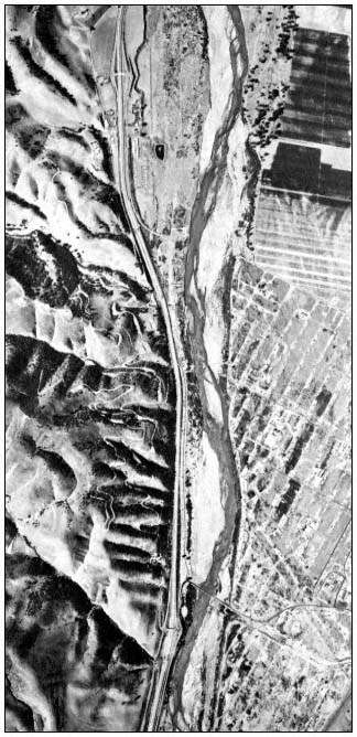
Figure l.
Aerial photograph of Salinas River at Texaco's San Ardo
oil field showing limits of vegetation in riverbed.
One stream that has been extremely troublesome with regard to establishing CE Section 404 jurisdiction is the Salinas River (fig. 1). The Salinas River system drains a mountain and foothill area of about 10,300 sq. km. (3,950 sq. mi.), exclusive of the Soda Lake watershed, which is a closed interior valley with an area of about 1,550 sq. km. (660 sq. mi.) (California Department of Public Works 1946). The main thread of the river is about 270 km. (170 mi.) long; it meanders through the valley in a generally northwesterly course to its mouth in Monterey Bay. Unusually high infiltration and percolation rates exist in the Salinas Valley floor due to porous soil in the alluvial floodplain. It is only during the winter season after moderate to heavy rainfall that these loss rates are reduced. After soil moisture condi-
[6] 33 CFR 323.2(h).
[7] 33 CFR 323.2(g).
tions conditions are satisfied, an intense storm of two or more days duration will cause a rapid rise in runoff. There is a large variation in the relationship of peak discharges between the tributaries to the main river channel and channel storage which account for these variations (US Army Corps of Engineers 1970). Because of these runoff and flooding characteristics, determination of the limits of 404 jurisdiction in certain reaches of the Salinas River is very difficult.
One such reach is approximately 8 km. (5 mi.) south of San Ardo (Monterey County), where Texaco, Inc. wanted to construct a two-lane vehicular and pipe bridge. The area is flat and without definitive streambanks from which ordinary high-water can be determined. The soils in the area are a mosaic of Metz Complex, Psamnents, and Fluvents in a band more than 1,200 m. (4,000 ft.) wide (US Department of Agriculture 1978). Thus, neither hydrology nor soils classification alone enabled the determination of what portion of the approach fills for the 320-m. (1,060-ft.) box-girder bridge was within the CE jurisdiction. Vegetation in the area included both willows (Salixlasiolepis and S . lasiandra ) and valley oak (Quercuslobata ). But, as mentioned previously, these species alone are not adequate to establish the limits of Section 404 jurisdiction. However, utilizing discoloration on an upstream bridge to assist in estimating the ordinary high-water mark, on-site analysis of soils, and delineation of the bank boundary using vegetation (see fig. 1), the CE was able to determine that approximately 12,200 cubic m. (16,000 cubic yd.) of material for the approach fills would be within CE jurisdiction.
In other areas the problem of determining jurisdiction becomes even more complex. There are about 80 km. (50 mi.) of non-continuous levees constructed by individual property owners along the Salinas River and its tributaries (US Army Corps of Engineers 1970). The areas behind these levees have had their hydrologic characteristics altered, soil conditions changed, and riparian vegetation removed; this is particularly true if the area is being or has been farmed. Thus, jurisdictional determinations, even with the three-parameter approach, in areas behind levees can be extremely perplexing.
Conclusions
Section 404 of the Clean Water Act is one of the authorities used by the CE in its process of balancing public interest when issuing a Department of the Army permit. Part of the public interest is the effective management and protection of riparian systems within CE jurisdiction. However, in arid California's intermittent streams, it is often difficult to determine the limits of Section 404 jurisdiction. Assessment of jurisdiction must frequently rely on more than one characterizing parameter (i.e., vegetation, soil, or hydrology). In addition, assessments must be analyzed on a case-by-case basis.
Literature Cited
California Department of Public Works. 1946. Salinas basin investigation. 230 p. State of California, Sacramento.
Cowardin, L.M., V. Carter, F.C. Golet, and E.T. LaRoe. 1979. Classification of wetlands and deep-water habitats of the United States. 103 p. Office of Biological Services, USDI Fish and Wildlife Service, Washington, D.C.
Flint, P.S. 1980. Simple soil testing in the laboratory. 5 p. Harvey and Stanley Associates, Inc., San Jose, Calif.
Goode, B.N. 1981. The public interest review process. National Wetlands Newsletter 3(1):6–7.
Huffman, R.T. 1983. Technical delineation of wetland boundaries within California riparian systems. In : R.E. Warner and K.M. Hendrix (ed.). California Riparian Systems. [University of California, Davis, September 17–19, 1981.] University of California Press, Berkeley.
Motroni, R. 1980. The importance of riparian zones to terrestrial wildlife. 83 p. Prepared for US Army Corps of Engineers, Sacramento Distict, Calif.
O'Brien, A.L., and W.S. Motts. 1980. Hydrologic evaluation of wetland basins for land use planning. Water Resources Bulletin 16(5):785–789.
Odum, E. P. 1978. Ecological importance of riparian zone. p. 1–4. In : R.R. Johnson and J.F. McCormick (tech. coord.). Strategies for protection and management of floodplain wetlands and other riparian ecosystems. [Callaway Gardens, Georgia, December 11–13, 1978]. USDA Forest Service GTR-WO-12, Washington, D.C. 410 p.
Smith, F.E. 1977. A short review of the status of riparian forest in California. p. 1–2. In : A. Sands (ed.). Riparian forests in California: their ecology and conservation. Institute of Ecology Pub. 15, University of California, Davis. 122 p.
US Army Corps of Engineers. 1970. Report on January and February 1969 floods, Vol. I. 21 p. US Army Engineer District, San Francisco, Calif.
US Army Corps of Engineers. 1981. Procedures for jurisdictional determinations under Section 404 of the Clean Water Act. 18 p. US Army Engineer District, San Francisco, Calif.
US Council on Environmental Quality. 1978. Environmental quality. Ninth annual report. 599 p. Stock No. 041-011-00040-8, US Government Printing Office, Washington, D.C.
US Department of Agriculture. 1978. Soil survey of Monterey County, California. 228 p. Cartographic Division, USDA Soil Conservation Service, Washington, D.C.
US Department of the Army. 1977. Regulatory program of the Corps of Engineers. Federal Register Part II 42(138):37122–37164.