Define Environmentally Sensitive Management Practices
As already implied, those in flood control activities are, whether they know it or not, involved in riparian resource management. Structural projects, flood control maintenance, and monitoring of private development all require actions which affect riparian resources. The goal of the resource management program is to guide these activities in a more environmentally sensitive direction. The program should, therefore, provide direction to implement new "environmentally sensitive" management practices. Such practices will relate to the organization's own activities as well as those private sector activities over which it has authority.
Best Management Practices
The management practices suggested here are carefully thought out "clay pigeons." They were created out of the experiences and knowledge of the program participants. We expect them to change as their results are monitored and analyzed. The flood control personnel will evaluate the practices' effects on channel hydraulics and capacity, and the potential threat to life or property. The resource manager will evaluate the practices' effects on physical stream elements, biological productivity, etc. All participants in the program will collectively weigh the monetary and environmental cost:benefit relationships of the practices.
Environmentally sensitive mangement practices exerpted from the Ventura County's 208 Water Quality Management Plan, (approved in 1981), are presented in example 8. Most have not yet been applied in the field, so evaluation is difficult. Each is denoted as a best management practice (BMP) and numbered.
Annual Development Plan
The best management practices in example 8 are oriented toward the activities carried out by the flood control organization itself. However, there are similar activities carried out by the private sector over which the flood control organization often has some control. The most common of these private-sector activities is sand and gravel mining. In Ventura County, sand and gravel mining operations are required to obtain a watercourse permit to operate in any channel within the jurisdiction of the Ventura County Flood Control District. The primary purpose of this permit is to ensure that mining operations are not carried out in a manner which would create a potential flood danger.
Example 8.—Best management practices adopted by the Ventura County Board of Supervisors.
BMP-1. Keep work in streams to an absolute minimum.
Description: Doing the minimum work necessary is, in most cases, something that results from budgetary constraints and good sense. It is, however, the most environmentally sound management practice that can be pursued and is, therefore, worthy of comment here.
Why needed: Streams are the result of millions of years of evolution. Man, however, has the capability of applying great amounts of energy (via earth-moving equipment) in a sudden manner and otherwise disrupting the ecological balance resulting from that evolutionary process.
No amount of money or human effort can result in an exact duplication of nature. Given a million years, certain riparian species may adapt to or even be dependent upon the changes man is able to make through flood control activities. Now, however, the best we can hope to do, even with good management practices, is to assist nature in restoring damaged portions of the ecosystems. Therefore, the best management practice is to disturb this unique, important environmental resource as little as possible.
BMP-2. Where flood control activities are necessary, maintain a portion of the stream in its natural condition and isolate it from the required work.
Description: There are a number of ways in which this management practice can be achieved. Where work must be done in an area where one main channel exists, it may be possible to leave one side of the channel intact. It may be possible to selectively leave portions of the stream vegetation on both sides. In either case, it is essential to maintain the main stream flow adjacent to or through those riparian areas left intact.
Where it is necessary to work in a riparian area that contains more than one channel, it is desirable to leave at least one channel intact with a "buffer zone" of riparian vegetation of at least 50 feet on each side of the flowing water. This normally requires the insertion of a "soft plug" at the upstream terminus of the channels. The "soft plug" should be engineered to maintain low flows in the channel left intact, but allow larger storm flows to wash out the plug.
When there exists a choice of preserving one of several channels, the most environmentally sound choice involves consideration of several factors. These factors include: Proximity to other terrestrial habitats, time of year, existence of unique aquatic resources such as pools, riffle and spawning beds, etc. It is desirable to seek the advice of qualified experts in considering these factors, such as the California Department of Fish and Game and the USDI Fish and Wildlife Service.
Why needed: This management practice will be, in many cases, the fastest, most economical and most environmentally sound technique for preserving riparian resources. Except for the diversion of flows, it does little to the area left intact. During dry periods or when natural flows are being diverted upstream, it may be an "aquatic plus" by concentrating low flows into one channel. If the same low flow channel is used over a period of several years, it allows for the growth of mature riparian plant communities.
BMP-3. Where the earth must be physically moved, store the top two to three feet of material and redistribute after the work is completed.
Description: This practice involves the skimming off of observable nutrient-laden soils, stockpiling them and then redistributing them over finished work areas. This is a desirable practice, particularly near new stream channels. It is extremely important, however, that stockpiled material not be pushed into flowing water. This practice should be employed in rocky sandy stream areas where nutrients (in clay and silts) are scarce. This practice need not be utilized where stream gradients and adjacent soil profiles provide a rich abundance of soil nutrients.
Example 8.—Continued.
Why needed: One of the most basic characteristics of streams and rivers is that they carry materials from upstream areas and deposit them in downstream areas. Some of these materials are nutrients essential to aquatic and terrestrial species along streams and rivers. As flood flows decrease, these nutrients deposit along the receding stream along with native plant seeds and soil dwelling organisms. Since many of the desirable elements do not remain for long, the riparian plant community has adapted by being extremely fast growing and hardy. Nevertheless, even the riparian plants cannot grow well (or at all) without essential nutrients. Unfortunately, many control practices remove or bury nutrient-laden soils. They also remove them from their essential close proximity to the flowing water. This not only results in the reduction (or absence) of riparian plant species, but also promotes higher water temperatures (from less shade), less dissolved oxygen, less wildlife cover, etc.
BMP-4. Where earth work is required, restore natural features such as meanders, pools, turbulence and braiding.
Description: The primary aim of this management practice is not to replace visual aesthetics (although that is a legitimate goal). Rather, the purpose is to assist nature in bringing the disturbed riparian environment back to its desired ecological balance. The manner in which these natural features are restored depends on the previous "natural" circumstances. In a large river system such as the Santa Clara system, it may be appropriate to cut new channels, encourage meander and build pool areas with heavy equipment. In a smaller system such as the Ventura system, it may be appropriate in some areas to create small falls and pools by hand.
In utilizing this management practice, there are no pre-set plans which can be applied to a specific situation. Each stream area will likely have a unique combination of stream elements. A degree of subjective judgment must be used in deciding how to restore natural stream elements. While there is not necessarily a "right" solution, there are "better" solutions. Obviously, the "better" solution is going to result from careful evaluation of the natural stream elements and knowledge of the probable consequences of flood control work. In most situations, the evaluation should be done in the field with input from a qualified maintenance supervisor and a qualified biologist. The primary factors to be covered in the evaluation are found in "Work Sheet for Field Evaluations" [example 9].
Once this evaluation is made, initial decisions can be made as to which natural features are to be restored. Some decisions must be made as work progresses and will require a degree of creativity on the part of the maintenance supervisor. Even though each situation will be unique, there are certain benchmark criteria which can be useful in making field decisions. These "benchmarks" are defined below.
Benchmark Criteria for Restoring Natural Stream Features.
1. Place a 1 to 2-ft. fall at approximately 1/8 mile intervals.
2. Creation of depressions for ponds should be in a ratio of approximately 3:1 with the adjacent stream (i.e., a 3-ft. wide pool would be in proportion to a 1-ft. wide stream).
3. Construct potential stream channels that will meander, rather than flow in a straight line where work exceeds 1/8 mile in length.
4. In all areas except ponds, leave bottoms rough and irregular rather than smooth.
5. Use existing elements, such as large rocks over 4-ft. in diameter and existing falls as much as possible.
6. Use hand methods in creating smaller falls, pools and braiding.
Why needed: The natural features of a stream can be best described as nature's most efficient and diversified molding of the physical environment. The biological environment has evolved to take maximum advantage of these natural features in an evolutionary process which has taken millions of years. Unfortunately man, through flood control activities, has the capacity to disrupt these natural features and therefore place stress on the biological environment. However, some of these features can be replaced or at least assisted back.
Example 8.—Continued.
BMP-5. Install culverts, silt curtains and other devices that control turbidity where work must be conducted in or adjacent to stream water.
The effects of turbidity on aquatic ecosystems have been discussed. The previous discussion of other best management practices has stressed the need to avoid work in flowing water unless absolutely necessary. If flood control activities are necessary in stream waters, there are a number of ways in which habitat destruction and stream turbidity can be minimized. The following general criteria should be used in applying this management technique.
1. Where equipment must cross flowing water on more than one occasion, install a pipe culvert of sufficient capacity to handle existing flows. The pipe invert should be at or slightly below the existing stream bottom at both ends. Use clean sand and rock to cover the pipe and avoid the use of silts and clays.
2. Where equipment must work adjacent to a stream or pond, establish a barrier to keep equipment and soil from getting in the water. The best barrier is distance and no barrier is necessary if work is in excess of 20-ft. from the edge of water. The next best barrier is native vegetation and no additional barrier is needed if a 20-ft. wide strip of vegetation greater than 6-ft. high remains between the water and the work.
Where work must be conducted closer than 20-ft., a temporary barrier of large rock and sand 2- to 4-ft. high can be constructed. In unique circumstances, a temporary barrier of wood or metal may be used.
3. Where work must be conducted directly in water and flows cannot be diverted, the work should be completed as quickly as possible. In larger water bodies, and where flow velocities permit, plastic silt curtains should be placed down from the work. In faster flowing water, a series of small falls (2- to 3-ft.) can be constructed of larger rock to slow water and encourage the deposition of silts and clays.
Why needed: The primary purpose of this management practice is to avoid the direct and indirect destruction of aquatic systems. Direct effects include the removal of natural stream elements such as pools, falls, rapids, spawning beds, etc. Indirect effects include the disruption of key elements of the overall riparian system and the creation of turbidity which is carried downstream. Increased downstream turbidity may cover spawning beds and benthic (bottom) organisms. It may reduce total dissolved oxygen in the water and otherwise place additional stress on fish, aquatic plants and other aquatic organisms. Finally, turbidity can affect aquatic systems for many miles downstream of the occurrence.
Past experience with watercourse permits indicated that the conditions defined in some permits were not always consistent with those defined in permits required by other agencies. Specifically, it was found that the conditions of the watercourse permit and the Stream Alteration Agreement required by the California Fish and Game Code were sometimes at odds. Therefore, in the interest of better cooperation and resource management, the Ventura County Flood Control District initiated the Annual Development Plan (ADP) process in 1978. A typical annual development plan is developed according to the general schedule defined below.
1. Early spring—The sand and gravel company obtains aerial photographs and topography maps of the proposed excavation site after the winter rains are over.
2. April—The company submits a proposed ADP which includes the aerial photographs, topography and proposed vertical and horizontal extent of excavation for the coming year.
3. May—Meetings are held with the applicant, flood control district engineers, and representatives of the California Department of Fish and Game (DFG). The purpose of these meetings is to identify the concerns of each party and to reach agreement on a plan.
4. May to June—Once a compromise agreement is reached, the ADP is finalized. The final ADP consists of: a) an aerial photograph with horizontal elements identified (for example, see figure 9); b) topography maps, cross sections and profiles defining vertical elements; c) the watercourse permit for the year; d) the DFG permit.
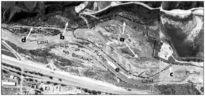
Figure 9.
Aerial photograph indicating typical items agreed upon for an Annual Development Plan: a) area of potential excavation;
b) wildlife corridor from mountainous area to top of photo; c) soft plug; d) haul road; e) low-flow corridor.
The Annual Development Plan process has proven to be reasonably successful in preserving riparian resources. All ADPs issued thus far have preserved a riparian corridor through excavation areas. A minimum buffer zone of 12–15 m. (40–50 ft.) on either side of the "low-flow" stream (fig. 9) has been maintained. Wildlife migration corridors have been identifed and reserved. Culverts are required at all stream crossings to protect the aquatic environment from turbidity. Finally, there has been an effort to create and maintain permanent low-flow areas and preserve significant mature riparian areas.