XII. Sand, Silt, and Sea-floor Spreading:
Studies in Marine Geology
“In 1940,” wrote H. William Menard in 1969, “it appeared that the sea floor was a relatively quiet place with minimal relief and that all mountain building and other important geological processes occurred on continents or at their margins.”[1] At that time the known relief of the Pacific basin was a few deep trenches and bits of the mid-ocean ridge system, discovered on the few prewar explorations and cable surveys.
Then geologists began going to sea, many of them because the Navy asked them to go. They went with enthusiasm and great expectations, carrying an encyclopedic knowledge of the native customs on each tropic isle. In general, those at Scripps subscribed to Menard's theme: “There is no virtue in going to an unpleasant atoll if a beautiful one has the same geology.”[2]
During the 1950s, “shattered beliefs soon became a commonplace as it developed that almost everything supposed about ocean basins was wrong.”[3] That “relatively quiet place” was found to be gashed by trenches, humped with undersea volcanoes and flat-topped guyots, and arched by rises and ridges. To marine geologists the
By the 1960s it had become apparent that in the ocean basins are found the most active areas of the earth's crust. Now it is believed that new crustal material slowly rises from the mantle at oceanic ridges and spreads to the sides, leaving its record in the reversals of magnetization of the rocks. The surface of the earth is divided into about ten major rigid plates which are moved in respect to one another by deep, as-yet-unknown forces. The land areas are carried by these motions toward or away from each other. Where two plates meet, one is thrust beneath the edge of the other, usually in a deep oceanic trench.
To reach these conclusions, geologists have joined forces with geophysicists. Together they have devised a remarkable roster of hardware, much of it developed or put to ship-board use quite recently, and some of it apparently susceptible to mal de mer. A geologically oriented expedition setting out now carries echosounders, heat-flow probes, gravity meters, corers, magnetometers, deep-sea cameras, grab samplers, dredges, and assorted seismic equipment. Huge winches and towering A-frames manipulate the gear, along with straining muscles.
Scripps Institution has been, of course, only one of many research centers that have contributed to the discoveries in geology (some of which are also covered in this book in chapter 4). Equipment and theories have been invented all over the world, and borrowed freely. Scripps scientists have ridden ships of other institutions and have reciprocated with their own ships. Scientists have moved from one institution to another, also, bearing their favorite ideas. Scripps has contributed the results from a great many expeditions throughout the Pacific Ocean, some in the Indian Ocean, and a few in other seas. The institution has also contributed to the floor of the ocean a great many
Marine geology on the west coast began with Francis P. Shepard at Scripps Institution and almost simultaneously on the east coast with Henry Stetson at Woods Hole Oceanographic Institution. Shepard entered the geology profession in the 1920s only to be “assured time and again that the major problems of geology had been solved”[4] — but he didn't believe it. A summer of sea-floor sampling from his father's yacht off New England quickly showed him that offshore sediments were not evenly distributed outward from coarse to fine as the textbooks had said. In 1933 he spent part of a sabbatical from the University of Illinois in La Jolla; he was then identified in the local paper as “one of the most energetic students in the U.S. … of marine bottom deposits and the configuration of the sea bottom.”[5] Four years later he moved to Scripps as a visiting investigator to find out about sediments, incidentally bringing with him the largest grant ever awarded up to that time by the Geological Society of America: $10,000.
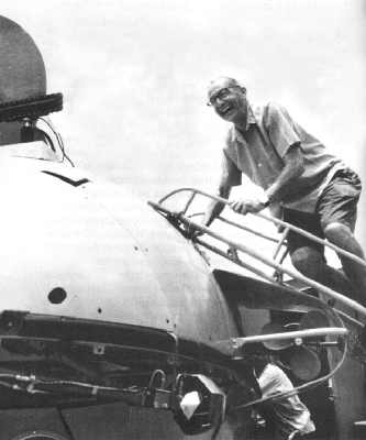
Francis P. Shepard beaming as he enters the Diving Saucer for a look at his submarine canyon. Photo by Ron Church.
Simply by wading and rowing out from shore, Shepard became a marine geologist. Essentially his approach has been to extend land geology onto the sea floor, and he has continued to work chiefly on nearshore phenomena. In those primordial days of marine geology, Sverdrup looked at it differently: “The work of Shepard is not oceanographic,” he noted in 1937. “We shall continue work in sedimentation which is a problem in oceanography, but to us details of the submarine topography are of small interest and the geological character of the rocks forming the bottom is insignificant.”[6] Shepard continued his work at Scripps under the Geological Society grant, alternating between the seashore laboratory and the University of Illinois. In 1942 he joined the University of California
On his arrival at Scripps in 1937, Shepard quickly had his eye and sextant on, his rowboat over, and his sounding line in Scripps submarine canyon, while awaiting the conversion of the E. W. Scripps into a research ship. With sounding line, with the help of a helmeted diver, and later of Scuba divers, with echosounder, with marker buoys, with underwater camera, and from diving saucers, he has mapped and pored over “his” canyon for almost forty years, until it has become certainly the best known in the world. (Shepard's long-used shore points for map coordinates for the Scripps canyon have baffled more recent students, who can scarcely be expected to know that “NFG” is the north front gable of the house in which Robert Dietz lived long ago, or that the “monstrosity” is the Moorish-castle-style house on Torrey Pines Road.)
The helmet-and-airhose diver who explored the submarine canyon at first hand in 1947 for Shepard was Frank Haymaker, a zoology major from UCLA who learned geology in a novel way. As Shepard said: “Diving into a narrow submarine canyon which has vertical and even overhanging walls is a hazardous undertaking.”[7] Haymaker on the sea floor communicated with Shepard and the surface boat by two-way telephones. When Haymaker found interesting rocks, “a skiff was rowed over to the diver and a sledge hammer and a chisel lowered so that he could break off the rocks and send them up in a bag. … Haymaker obtained samples of the fill on the canyon floor by driving in pipes. The personnel at the surface would pull out the pipe, and
During the early 1950s, Scuba divers replaced the helmeted diver and continued the firsthand observations of Shepard's canyon.
A debate over the formation of submarine canyons raged for decades. For quite some time, Shepard and others advocated that such canyons had been cut by rivers and insisted that sea level had to have been sufficiently lower to allow for aerial erosion. But Shepard became persuaded that the depths were too great, and he now believes that the deep gashes in the continental slope were shaped by a combination of moderate lowering of sea level, turbidity currents, and other currents and mass movements. He bowed gracefully to the accumulating evidence and modified his opinion with the comment that “it is monotonous trying to support the same old ideas.”[9]
Shepard's interest in nearshore features has not kept him close to home; indeed, it has turned him into a world traveler, almost always to a delightful isle or shore with sun-drenched beaches. He selected the north side of Oahu, Hawaii, as a comfortable place to write Submarine Geology in 1946, and so on 1 April of that year he became an expert on tsunamis, earthquake-generated sea waves. He brought to the attention of the world that the first wave is not necessarily the highest — a point emphasized by his having lost his book manuscript and notes to the ninth giant wave. Himself he saved by scrambling up an ironwood tree and hanging on for dear life.[*]
[*] Mrs. (Elizabeth) Shepard had stayed on the high ground to which they fled after the first wave wakened them, while he returned to their house to salvage what he could.
Thereupon, he set out to measureWhile touring coastal regions over the years, Shepard gathered samples for dating sea-level fluctuations throughout the world. By means of radiocarbon dating, done chiefly by Hans Suess's laboratory (see chapter 13), he established that for the last 17,000 years the sea level has risen an average of 25 feet every thousand years, but more slowly toward the present. In recent years he has installed series of current meters to record the movement of material down — and up — a number of submarine canyons along the Pacific coast. While the net movement is downward, considerable back-and-forth motion of the sediments has also been recorded.
In 1966, the Society of Economic Paleontologists and Mineralogists established the Francis P. Shepard Award for Excellence in Marine Geology; they defined Shepard's areas of prominence as the distribution and characteristics of sediments, marine geomorphology, and the structure of the continental margins. Shepard, said science writer Bryant Evans, “gives you the impression of being engaged in a delightful hobby.”[10] His walk is ever jaunty, his tone is always enthusiastic, and his only variation from an ever-present smile is a beaming smile. Emeritus since 1966, he continues to pursue his hobby — very professionally — on beaches from Moorea in the Society Islands to La Paz, Baja California.
From 1951 to 1957 Shepard directed API Project 51, sponsored at Scripps by the American Petroleum Institute. This was a geologic study of the coastal waters of the Gulf of Mexico for the purpose of remedying “the admitted ignorance of geologists about the conditions of deposition of sedimentary formations similar to those in which oil is found.”[11] From 1954 API Project 51 was administered through the Institute of Marine Resources (see chapter 6).
The first area selected for detailed studies by API Project 51 was the northwest Gulf of Mexico, which has had rapid, large-scale deposition of sediments for a long time and is slowly subsiding. The project was “a joint effort by sedimentationists, biologists (including students of macroorganisms, foraminifera, ostracods, microfossils, and bacteria), clay mineralogists, chemists, and — to a limited extent — petrographers and physical oceanographers.”[12] The field workers maneuvered in small vessels, a marsh buggy, and an air boat along the Gulf coast and Mississippi delta to gather cores, mud, sand, and rock samples. These were analyzed in field and laboratory, in the hand and under the microscope, with mass spectrometer and X-ray diffraction, for microfossils and macrofossils, for organic content and remanent magnetism, for grain size and roundness, for areal extent and local variation.
Said Shepard: “Perhaps more than anything else the project has shown how important it is to use a multiple approach in diagnosing environment characteristics.”[13]
Fred B Phleger, who had been instrumental in bringing API Project 51 to the campus, called it “a liberal education in sedimentology for all of the numerous participants,”[14] and he summarized the accomplishments as: providing a detailed description of the sedimentary patterns of the Gulf coast region, analyzing the distribution of the organisms within them, summarizing the history of the Holocene rise of sea level on the continental shelf, and defining further problems in sedimentology.
As might be expected, the project continued. Tjeerd H. (“Jerry”) van Andel became project director in 1957, as API 51 was turning to studies in the Gulf of California, the site of Scripps Institution's first venture into geologic oceanography in 1939. Other geologists and geophysicists at Scripps were also interested in the great trough that splits Baja California from the mainland, so the Marine Physical
[*] The word is correctly spelled with either one “1” or two, and the participants in the expedition did not strive for unanimity on this point in their reports.
Sea Expedition in the spring of 1959, using the Spencer F. Baird and the Horizon; the participants took many soundings, collected core and dredge samples, gathered biological specimens, recorded gravity measurements, shot seismic-reflection profiles and refraction lines, and with Scuba gear and echosounder explored the submarine canyons off Cabo San Lucas.Visiting Danish biologist Henning Lemche was especially pleased with the capture of live Neopilina, a problematical mollusk-like creature that had been thought long extinct until a few live ones were trawled from a depth of 3,570 meters well off Costa Rica by scientists on the Galathea in 1952 and described by Lemche in 1957. He had visions of dredging other archaic forms alive from the depths of the Gulf of California with the aid of the newly developed Isaacs-Kidd deep-diving dredge that slid on underwater slopes as if on skis. Asides were made by some about the trilobite-canning expedition, but no other kinds of living fossils were hauled from the deep.
The seismologists were surprised to find that the crustal layer at the northern end of the gulf seemed to be continental while that at the southern end appeared to be oceanic. Might it be that the Baja California peninsula was being split away from the mainland by sea-floor motion?
While Vermilion Sea Expedition researchers explored the ocean depths, an overland trip along the marshy coastal plains of the eastern side of the Gulf of California was led by Joseph R. Curray, another of the early participants in API 51, one whom Shepard called a “remarkably good field
API Project 51 ended in 1962, at the choice of Scripps geologists, who turned elsewhere for the funding that was becoming too much for industry. The American Petroleum Institute had contributed more than one million dollars to the eleven-year study.
Curray has continued his interest in coastal sediments and the geology of the sea's margins. Often in collaboration with David G. Moore (long with the Navy Electronics Laboratory and its successor, the Naval Undersea Center), he has described coastal profiles and the evolution of continental margins. Curray and colleagues have graduated from dugout canoes to the largest Scripps vessels, from which they employ seismic techniques to determine the thickness and nature of sediments of the continental shelves and slopes. Using seismic profilers in 1966, Curray surveyed the continental shelf and slope along eastern North and South America, and concluded that continental slopes are chiefly depositional features.
In 1967 Curray and Shepard coordinated Carmarsel Expedition to resolve questions on sea-level fluctuations. As Curray commented just before the trip: “In most areas, we cannot determine whether the land has been going down or the sea has been going up.” The chosen area was the Caroline Islands and the Marshall Islands in the southwest Pacific, where uniformly submerged terraces had been reported. Geologists from Cornell University, the American Museum of Natural History, the U.S. Geological Survey, and Yale University participated, along with those from Scripps, including biologist William A. Newman. On Carmarsel, the group surveyed the topography of the islands, sampled marine terraces, collected shells for dating, and drilled the coral islands. The results were not simple; the group
Douglas L. Inman, a physics major at San Diego State University, after World War II became a student of Shepard's and joined the Scripps staff upon completing his Ph.D. in 1953. Combining physics and fluid mechanics with geology, he has concerned himself with the processes in the wave zone, where man comes into conflict with the ocean. Where the sea meets the land, storm waves may undermine foundations, rip currents may drag swimmers seaward, favorite beaches gradually disappear, and harbors slowly fill with silt. These problems have become Inman's problems. He and his co-workers constitute the Shore Processes Study Group, which uses both instruments and Scuba gear to study the mechanics of the beaches. This program at Scripps is almost unique among oceanographic laboratories, and has become of increasing interest as man encroaches upon the sea.
Rip currents have been a subject of concern, and curiosity, to Scripps scientists for many years. Shepard, K. O. Emery, and Eugene LaFond measured and pondered them during the 1930s, and Inman and colleagues have continued studies in more recent years, finally to conclude that rip currents are caused by the interaction of incident surface waves with longshore edge waves. Following the suggestion by Inman that edge waves might have an important influence on nearshore circulation, Anthony J. Bowen presented his evidence for the formation of rip currents in 1967 at the only defense-of-doctorate ever held in the Hydraulics Laboratory, where he produced rip currents in the wave basin as part of his presentation. Edge-wave interaction has been found by Inman's group to form nearshore circulation cells and various common beach features such as beach cusps and crescentic offshore bars.
The transport of sand by waves was an early study of Inman's. He and Edward D. Goldberg devised a method of
The Shore Processes Study Group is continuing to determine what happens in the churning wave zone.
Not many years ago [wrote Birchard M. Brush and Inman], it was a logistic triumph for an oceanographer to dip one instrument in the ocean in order to acquire a pitifully limited amount of information on one or two parameters of the many he wished to know.
The present program embraces the continuous and simultaneous acquisition of current velocity in two orthogonal directions, wind speed and direction, a directional array of accurate pressure sensors for determining wave directional spectra, a modern digital wave staff to measure surface displacement, and thermistor arrays for measurement of the thermocline.[15]
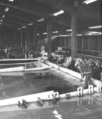
Anthony J. Bowen demonstrating the formation of rip currents in the wave tank of the Hydraulics Laboratory in 1967, for his doctoral committee and audience.
Through these simultaneous measurements, the Shore Processes Study Group has concluded that “the important processes that operate in the nearshore waters of oceans, bays, and lakes are similar. … Moreover, it is becoming increasingly clear that processes in nearshore waters are driven by basic, interrelated forces that are systematic and essentially regular in form. These systematic driving forces lead in turn to the development of coherent processes such as the nearshore circulation cells and the longshore transport of sand that are basically similar the world over.”[16]
The concept of uniformity of the coastal processes, which vary only in relative magnitude from place to place, has made it possible to predict the impact of a particular change — such as a structure — on a particular beach area.
The sediments of the deep sea have drawn the attention of a number of Scripps geologists through the years. These thick layers are derived from several sources and are rearranged by deep currents, by turbidity currents, and by burrowing creatures. Sand, mud, and rocks wash into the sea from rivers (and fall from melting icebergs); undersea volcanoes spew material into the ocean and above-sea volcanoes pour lava and fine ash into it; the winds carry minute dust particles far from land; and always a constant rain of dead organisms drifts downward to the sea floor. Tiny plants and animals of the surface waters occur in such vast numbers in some areas that their hard shells through the millenia pile up into a thick slurry of soft ooze. There are radiolarians, diatoms, and silicoflagellates — with shells of silica — and there are foraminifera, coccolithophores, and pteropods — with shells of calcite. Sponges dwelling on the sea floor at all depths leave siliceous spicules when they die, and from the fishes are left scales and teeth and bits of bone. The sediments in shallow water are rich in calcium carbonate, but many of the calcite shells are dissolved before
One of the first puzzles about the deep-sea sediments was why they formed such a thin layer. In 1946 the Dutch geologist Ph. H. Kuenen estimated that the average thickness of ocean sediment should be three kilometers, if the earth were, as then estimated, two billion years old. On Midpac and Capricorn expeditions seismologist Russell W. Raitt found the sediment column only about 300 meters thick (east-coast seismologists at about that time found the sediments in the Atlantic about 450 meters thick). Cores of older sediments from the sea floor were rarely older than Upper Cretaceous; none were apparently older than Lower Cretaceous (135 million years before present). Where was the rest of the geologic column that should, in the undisturbed floor of the ocean, leave a record to the beginning of time?
It took many years of work by geologists and geophysicists to resolve the puzzle. They concluded that the floor of the ocean was certainly disturbed. The older sediments are now thought to have been systematically destroyed as new crustal material has been forced upward and outward along the sea floor.
The sedimentologists have had plenty of material to work with, however. The early cores, only five meters long, could represent many years of geologic time, and longer cores were soon available.
One of the earliest Scripps workers in this field was Milton N. (“Bram”) Bramlette, who transferred to Scripps from UCLA in 1951. He continued to demonstrate “his ability to throw light upon very large problems by his study of very small objects, the remains of microscopic and sub-microscopic life of ancient seas”[17] — which led to his receiving an LL.D. from the University of California in 1965, the first awarded in ceremonies at UCSD.
Texas-born Bramlette had spent eighteen years with the U.S. Geological Survey before he joined the staff of UCLA in 1940. The Department of the Interior acknowledged his studies with the Distinguished Service Medal in 1963, when they cited “his study of the origin of the siliceous rocks of the Monterey formation, which won for him international recognition; his study of trans-Atlantic deep-sea cores, which resulted in the first trans-oceanic correlation of glacial deposits; and his understanding of the origin of the Arkansas bauxite deposits, which permitted effective exploration that led to the discovery of major sources of aluminum ore.” By then, Bramlette was identifying coccolithophores, discoasters, and calcareous nannoplankton in Pacific cores also, from Capricorn Expedition, in which he had participated, and from later Scripps expeditions.
Fred B Phleger also joined Scripps in 1951, when he made permanent what had been a visiting position while he was on the staff of Amherst College and Woods Hole Oceanographic Institution. Phleger set up and headed the Marine Foraminiferal Laboratory, which has integrated geology and biology in its analysis of fossil foraminiferal shells in marine sediments and in the taxonomy, distribution, and ecology of living foraminifera that eventually add to those sediments. Phleger and Frances L. Parker, when they first arrived at Scripps, began studies of the successions of foraminiferal assemblages in cores from the North Atlantic Ocean and Mediterranean Sea, taken on the Swedish Deep-Sea Expedition in 1947 and 1948. Scripps expeditions were soon providing cores from throughout the Pacific Ocean. Frances L. Parker enlarged the studies of foraminifera to analyze the factors that influenced the assemblages on the sea floor and in the geologic record. She also worked on shallow-water foraminifera, stressing the ecological aspects of their distribution. A great deal of taxonomic revision was required in this complex group of simple animals.
In more recent years Wolfgang Berger has undertaken studies on the solution of foraminifera shells and coccoliths in sea water, and the distribution of carbonate in the deep ocean. He determined that most of the dissolution takes place on the sea floor, not during settling through the water. Berger and colleagues have mapped the distribution of the present-day calcite-compensation depth for comparisons with other periods.
William R. Riedel began at Scripps by joining Northern Holiday Expedition in 1951 and becoming a staff member in 1956. His specialty has been the intricately shelled radiolarians, a complex group of organisms that he has found defies easy classification. They can, however, be used as indicators of geologic age, and by the mid-1960s Riedel was detailing the movement of fossil radiolarians away from the East Pacific Rise, a movement that became one more verification of sea-floor spreading. He has analyzed radiolarians from all the oceans and from marine sediments on land, and has, for example, been able to establish a radiolarian zonation that divides the Cretaceous period into seven parts. Since the mid-1950s Riedel also has been curator of the Scripps collection of sea-floor cores and dredged rocks.
Gustaf O. S. Arrhenius began his studies at Scripps on deep-sea cores and has gone into several other fields as well: chemistry, physics, and space science in particular. Born in Stockholm, Arrhenius was a staff geologist on the Swedish Deep-Sea Expedition of 1947 and 1948, and shortly after receiving his Sc.D. from the University of Stockholm in 1952, he accompanied Capricorn Expedition as a visitor. He joined the Scripps staff the following year.
Arrhenius has delved into theories on the origin of life from organic material that existed before the formation of the earth; on the nature of comets; on asteroids; and on the earth's moon and its composition. In 1966 he helped to establish the Institute for the Study of Matter, and in 1970
Edward L. (“Jerry”) Winterer transferred to Scripps from UCLA in 1962 and has also delved into the ages of sediments. “The ocean basins have a lucid but very short geologic memory — about 200 million years,” Winterer once said, and he has gone also to continental rocks — which he once called “dusty and badly kept archives” — to help extend the geologic record. Winterer and Riedel in 1969 announced the recovery near New Guinea of an unusually complete core by the Deep Sea Drilling Program's Glomar Challenger, a core that contains “an almost complete record” of radiolaria, foraminifera, and nannofossils through 30 million years.
The structure and the topography of the Pacific basin have interested Scripps geologists since 1950, when Midpac Expedition set out. H. W. Menard was then in the Sea-Floor Studies group at Navy Electronics Laboratory, a co-sponsor of the expedition. That group — Robert S. Dietz, Edwin L. Hamilton, Edwin C. Buffington, Robert F. Dill,
In 1955 Menard was appointed to the Institute of Marine Resources at Scripps (see chapter 6). His early interest had been in turbidites, coarse sediments presumably transported from their land source by turbidity currents. He developed a reputation for being able to read echograms faster than anyone else and, in fact, he looked at more of them than anyone else. He soon was describing the topography of the sea floor and the origin of its features — from ripple marks and fan deposits to fracture zones, the Mendocino Escarpment, the East Pacific Rise, and, later, the geometry of tectonic plates.
In 1957, through IMR, Menard set up a bathymetric survey of the northeastern Pacific Ocean, to which the Bureau of Commercial Fisheries also contributed. Their interest was in aiding tuna fishermen, who had long known that tuna, and other fish, congregate near seamounts and submarine banks. Fishermen who came across such a feature usually kept the location secret and returned to it repeatedly. BCF persuaded the fishermen to yield their secrets, for the advantage of all. Gerald V. Howard, then director of the Biological Laboratory of BCF, noted in 1960 that the accidental discovery of Shimada Bank,[*]
[*] Named for Bell Shimada of the Inter-American Tropical Tuna Commission, who was killed in a plane crash in Mexico en route to join the Spencer F. Baird in June 1958. Also killed were Townsend Cromwell of Scripps and three women family members of ship's personnel.
off the west coast of Mexico, led to large catches of yellowfin tuna; this set in motion the cooperative project of analyzing and plotting the large amount of sounding data gathered in the previous decade by Scripps vessels and by those of BCF,The project enlarged, so that by 1961 an equal-area bathymetric chart of the Pacific basin and a physiographic diagram of the northeastern Pacific Ocean had been completed. By the mid-1960s Stuart M. Smith had devised a computer program to handle the formidable task of coordinating the routine ship records of bathymetry, magnetics, and seismic data. These are indexed, correlated with navigation records, and filed in digital form on magnetic tape or on charts of the Pacific Ocean. Under the direction of Thomas E. Chase from 1970 to 1976, the Geological Data Center provides its data and charts to anyone interested — and fills many such requests from fishermen, oceanographers, oil companies, and Sunday sailors. “Eventually,” the compilers say, “all oceans are to be mapped in a painstaking and patient accumulation of bits and pieces of data gathered by the world's oceanographic community.”[18]
As a separate mapping project, Jacqueline Mammerickx (Winterer) has been compiling bathymetric charts of the South Pacific, on which she has identified three fracture zones and a series of magnetic anomalies in that area.
One of the chief problems in compiling a map of the ocean floor is simply knowing where the ship was that recorded the depths. Echosounders may provide precise depths to the sea floor, but a surface reference point is needed. Star and sun sights can be marred for days by overcast, and currents skew the dead reckoning figures calculated from course and speed. On Scripps expeditions, the “discussions” have often been quite sharp between scientists and officers on the bridge as to where the ship has been for a number of hours. “Part of the problem for many years,” said one expedition leader, “was ever getting a captain to admit that any of his sights were less than perfect.” On one
Two-ship operations enlarge the scope of the discussions. Menard gave an example of an attempt by Argo and Horizon in 1967 to find each other 22 hours after they had separated:
Waving to each other we parted [at 0800 hours] and since each could clearly see the other, we absentmindedly assumed that we were at the same point. … I think it a rude awakening to climb out of bed at 0600 hours, pour down half a cup of aging coffee, walk to the bridge to find that the dead-reckoning position is in doubt by ten miles, walk to the laboratory and learn that the depth is almost a mile shallower than expected, and radio Horizon to learn that according to their dead reckoning the ships should be almost side by side. Near us they were not. … I radioed Horizon to ask where it had been when we were last side by side. (Navigators get nervous if you ask them where they thought they had been.) A long pause followed. … The radioed position showed that, as we waved at each other, the navigators on the two ships had differed by about twenty miles in their opinions of our position. … The ships reversed course and somewhere in the mist and rain squall that frustrated our Radar, we hoped that we were headed toward each other for a rendezvous.[19]
Over the years, the development of Loran helped, in those areas within the network, but the greatest improvement has come through satellite navigation, which was released by the Navy for use by civilian ships in 1967. Even this has its limitations, and the sextant is not yet obsolete, nor yet absolute.
Among the sea-floor oddities that attracted the attention of the roving geologists were the manganese nodules, soft rocks that look much like potatoes blackened in a campfire. Menard, under IMR auspices, in the mid-1950s began a survey of the abundance and distribution of manganese nodules throughout the Pacific, using dredges, corers, and deep-sea cameras. Chemical analyses by Edward D. Goldberg and Gustaf O. S. Arrhenius indicated significant amounts of manganese, iron, cobalt, nickel, and copper in the nodules. Goldberg analyzed by the ionium-thorium method the unusually large nodule that had been uniquely acquired on Northern Holiday Expedition (see chapter 15) in 1951; he found that its rate of growth was somewhat less than 0.01 mm per thousand years — “probably one of the slowest reactions occurring in nature in which a measure of the rate of the reaction can be ascertained.”[20] Southeast of Tahiti on Downwind Expedition in 1957, Menard found nodules in sufficient quantity to represent a potentially minable resource, and he compiled photographs from Scripps and Soviet expeditions of the International Geophysical Year to determine the regions of greatest concentrations of these odd rocks. From sea-floor photographs Menard and Shipek in 1958 estimated that twenty to fifty percent of the deep-sea floor in the southwestern Pacific is covered with nodules. John L. Mero joined IMR (on the Berkeley campus) for several years to carry out feasibility studies and soon concluded that mining the nodules for valuable minor minerals was economically sound. He then went off to set up a company to try sea-floor mining.
Exploration of the deep trenches of the Pacific by Scripps began on Capricorn Expedition in 1952, when geologists on the Horizon surveyed the “challenging oceanic complex” known as the Tonga Trench for nearly a thousand miles, with “all of the best instruments and scientific ideas
For several years the declared deepest spot on earth was shifted among four trenches, depending upon which one was last visited by a research ship: the Kurile Trench, northeast of Japan; the Mindanao Trench, off the Philippines; the Tonga Trench, east of the Tonga Islands; and the Mariana Trench, southeast of Guam. Fisher finally resolved the question, from echo-sounding records that he took with precise sounders over the Tonga, Mindanao, and Mariana trenches and from soundings by Soviet oceanographers over the Kurile Trench. Challenger Deep in the Mariana Trench won the contest, with a record depth of 35,810 ± 30 feet; Tonga was second, with a maximum depth of 35,435 ± 6 feet, and Mindanao (or Philippine) third, at 32,910 ± 20 feet.[*]
[*] Cook Deep in the Mindanao Trench briefly held the deepest record, which was cited in some authoritative articles, but a few months after the record depth was announced the echo sounder was found by the Royal Navy Commander of the surveying ship to have been “producing” soundings about one-sixth deeper than it should have.
So the Mariana Trench was selected for the world's deepest dive, by the U.S. Navy-owned submersible Trieste in 1960, when Jacques Piccard and Lt. Don Walsh reached the bottom of the sea.Fisher has returned often to the areas of the deepest trenches and to not-quite-so-deep ones as well, such as the Middle America Trench and the Peru-Chile Trench. He probably holds the record for time at sea among Scripps senior scientists. With the advent of the International Indian Ocean Expedition, he turned his attention to the Indian
After many days at sea, any piece of land looks attractive, and the stunning islands of the Pacific look like paradise indeed. Scripps geologists have never had to struggle for an excuse to get ashore: on Hawaii, to visit Kilauea volcano; on Consag Rock in the upper Gulf of California, because it was rumored to be granitic (it isn't; the light color proved to be guano); on Bayonnaise Rocks, because a submarine eruption had occurred there a year before; on Easter Island, to see the giant carvings; on St. Paul in the southern Indian Ocean, to see the penguins; on the Galápagos, to pay homage to Darwin's isles; on Rapa; on Pitcairn; and more. Capricorn Expedition in 1952 led geologists to Ocean Island, an uplifted atoll with deposits of phosphate:
We were somewhat interested in dating the uplift and inquired about possible fossils [wrote Fisher to Shepard]. The result was most gratifying. While we sat in the shade sipping Melbourne Bitter Ale the inhabitants brought us beautifully preserved fossil echinoids and clams they had been using for doorstops and paperweights.[23]
The explorers paused too at Rotuma Island, in the hope of determining on which side of the andesite line[*]
[*] For some years the basic rocks of the Pacific Ocean basin and the acidic rocks of its continental borders were considered separated by the andesite (from Andes) line. Detailed geologic studies over the years have made this simple demarkation less significant.
the islandA native named George, who had been to school in Suva, knew where there were some outcrops and led us off through some of the lushest jungle I ever saw [wrote Stewart to Shepard]. Cocoanut palms and banana palms, banyan, breadfruit, papaya, and mangoes grew in profusion, frangipanis and hibiscus were the only flowers I could recognise, big land crabs sidled into their holes in the trail as we passed and then came back out to peer after us, birds called. … George led us perhaps a mile back in the jungle where we happily thumped away at the volcanic rocks, much to the amusement of George and the brood of urchins that tagged along after us. …[24]
From such brief island stops, tons of rock have been transported back to home port for analyses (and rock gardens).
Indeed, when Albert E. J. Engel moved from Caltech to Scripps in 1958 he observed that the institution collections of island rocks were enormous but that samples from the floor of the ocean were skimpy. He doubted that island rocks were typical of the Pacific basin, and he set out to gather quantities of sea-floor rocks to test his guess. His wife, Celeste, of the U.S. Geological Survey, carried out the analyses of these samples with him. “To our surprise, and delight,” said Engel, “when we dredged in the Atlantic and the Pacific and the Indian oceans, we found the rocks extraordinarily unique, kindred to achondritic meteorites, and unlike all previous conceptions of basaltic and other mafic rocks of the volcanic edifices built upon the ocean floor. This was, perhaps the most exciting petrological find of its time.”[25] Engel has been particularly interested in the history of the earth's crust. His quest has sent him far afield
Hauling rock samples from the floor of the ocean, which Scripps has been doing for a quarter of a century, is not easy. Such rocks from the walls of trenches or from the slopes of seamounts where they are not covered by sediments can provide clues to the geologic history of the ocean basins and to the reflecting layers that are recorded by seismologists elsewhere beneath the sediments. The collecting method is by dredge, but, as Menard said:
The whole idea of dredging is preposterous. We stop a ship over a spot where we have every expectation that the bottom is irregular solid rock; we then lower a dredge on a steel cable a fraction of an inch thick and a mile or so long and attempt to break the rock without breaking the cable.[26]
Indeed, sometimes all goes awry, as on an early attempt at dredging on Capricorn Expedition:
One incident nearly broke our spirits [wrote Fisher to Shepard]. Running eastward up from a depth of 4800 fathoms, we came upon a seamount 100--120 miles east of Vava'u [Tonga Islands], which reached to within 225 fathoms of the surface. We attempted to dredge. The 1/2-inch line is old and snapped near the bail when the dynamometer hardly registered a serious stress, though it was obvious we were somewhat hung up. Slightly daunted, we assembled and wove up the remaining dredge, put it over, and, after it was on bottom 15 minutes, lost it in the same manner. Considering the experienced personnel — Menard,
― 295 ―[Robert F.] Dill, [Harris B.] Stewart, and Fisher — we prefer to think the fates were against us.[27]
Such near-spirit-breaking is not entirely a thing of the past. On the second leg of Eurydice Expedition in 1974, a dredge was left in the Canton Trough south of the Line Islands, and 8,000 meters of wire followed it to the floor of the trough when the cable snapped. Graduate student Bruce Rosendahl, otherwise always cheerful, didn't smile again until the next day, when another dredging attempt was successful. On the third leg of Eurydice, another scientific party “left one dredge and 367 m of wire on flanks of Combe Bank.”[28]
Nevertheless, Scripps geologists have persisted in collecting, principally by dredging, the hard rock samples that provide “ground truth” for the sea-floor spreading hypotheses about the movements or collisions of crustal plates and the composition of the lower crust. Collections of abyssal rocks available for study at Scripps Institution now are second to none. Fisher in particular has become adept at retrieving well-located and fresh specimens of ultramafic and mafic igneous rocks from the deepest walls of the major trenches of the western Pacific. His work in collaboration with Celeste G. Engel has confirmed not only the chemical and petrographic uniformity of the low-alkali basalts characteristic of the shallow layers of the oceanic crust, but also has established the extraordinary range of igneous rocks that, perhaps as sills or crudely stratiform bodies, comprise the deeper layers of the oceanic crust and possibly upper mantle: lherzolites and other peridotites, gabbros of several varieties, anorthosites and titanium-rich gabbros similar to those that have been found on the moon, and even plutonic rocks rich in silica previously thought to be characteristic of continental areas.
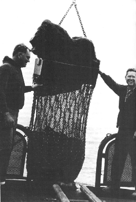
George Hohnhaus (left) and Edward L. Winterer showing off a particularly successful dredge haul in the southern California borderland, in 1964.
The recent trend in marine geological studies is interpreting the history of specific regions. The ships crisscross anomalous areas, bearing questions and drawing out answers.
Menard, for example, planned Nova Expedition in 1967 “to try to determine the development and geologic history of the peculiar Melanesian region in the southwestern Pacific where the sea floor seems to be part continent and part ocean basin.”[29] He summarized the cruise's wonders and woes in Anatomy of an Expedition. Thanks to Harmon Craig, when he was scientific leader on the Argo, that trip put Dixon Seamount and Hohnhaus Seamount on the map, in honor of two Scrippsians who made many an expedition's accomplishments possible. George W. Hohnhaus, sometimes called Big George, because he is, began working for Scripps in 1953, and proved well-nigh indispensable at handling shipboard oceanic equipment. He has spliced wire, rigged equipment, and hoisted more load than one person should. A former underwater demolition expert, he has served as explosives shooter aboard ship, and he was a qualified scientific Scuba diver. Fred S. Dixon, who began at Scripps in 1955, also proved adept at rigging equipment, ingenious at developing and building shipboard gear, and useful as a general expediter. He wrote many sections of the Marine Technician's Handbook, a manual continuously updated by Scripps personnel for shipboard work. Dixon is not quite as big as Hohnhaus, but he was “given” the larger seamount, which was found and surveyed by researchers on the Argo while Dixon was aboard. The two peaks are about halfway between Midway Island and the Fiji Islands. Dixon Seamount measures 38 miles across the tip and is 13,100 feet high; Hohnhaus Seamount is about 32 miles across and 12,400 feet high. The two honorees will never get more than a glimpse by photograph, if that, of their mountains, because the tops are almost a mile beneath the surface. The crew members and scientists then on Nova
The vast Indian Ocean was a new area to peruse and describe after the first Scripps trip there in 1960 (see chapter 15). Robert L. Fisher, who coordinated and led several trips across that ocean, outlined the bathymetry. The Mid-Indian Ocean Ridge, “part of a world-girdling system of earthquake-prone submarine mountain chains where new crust is being created and emplaced as volcanic rock,” was surveyed on Lusiad Expedition (1962--63), Dodo Expedition (1964), Circe Expedition (1968), and again on Antipode Expedition (1971).
Joseph R. Curray and David G. Moore on the latter two expeditions explored one of the world's great natural dumps: The Bengal Deep-Sea Fan in the Bay of Bengal. This pile of sea-floor sediments has been poured into the ocean from the great Himalayan Mountains by way of the Ganges and the Brahmaputra rivers. By surveying and through seismic reflection and refraction profiling carried out by Russell W. Raitt, the fan was found to be 3,226 kilometers long, 1,613 kilometers wide, and 16,460 meters thick at the landward end. Turbidity currents have left meandering and braided channels, rimmed with natural levees, much like river-delta features on land.
In the latter 1960s the trend in geology turned to sea-floor spreading, and fairly quickly every Scripps expedition was bringing in evidence. Menard presaged the turn in a letter to Director Nierenberg on 12 November 1966:
I just returned from a remarkable meeting in New York and I cannot let a month pass before I return from the South Pacific without letting you know my views on the consequences for Scripps. Sea floor creation and spreading centered on the mid-ocean ridge
― 299 ―and rise system is now demonstrated although the mechanism is still in doubt. This means that the history of the ocean basins is capable of being unraveled through mapping and sampling of magnetic anomalies and the rocks of the second crustal layer.…It is my impression that marine geology and geology as a whole are at a turning point comparable to physics when radioactivity was discovered. It will be a very exciting time for participants but a sad time for onlookers. …
The participants — a number of geologists and geophysicists at various institutions, sparked by a dynamic group at Cambridge University in England — were putting together the details of the theory of plate tectonics. In 1967 Dan McKenzie, then at Scripps Institution, devised the idea of using rigid-body rotations to describe plate motions, and with Robert L. Parker, then newly arrived at Scripps, he published a significant paper on tectonics on a sphere.
Graduate student Tanya Atwater was drawn into the theorizing at that time. She later wrote:
Sea floor spreading was a wonderful concept because it could explain so much of what we knew, but plate tectonics really set us free and flying.
…From the moment the plate concept was introduced, the geometry of the San Andreas system was an obviously interesting example. The night Dan McKenzie and Bob Parker told me the idea, a bunch of us were drinking beer at Little Bavaria [in Del Mar]. Dan sketched it on a napkin. “Aha!” said I, “but what about the Mendocino trend?” “Easy!” and he showed me three plates. As simple as that! The simplicity and power of the geometry of those three plates captured my mind that night and has never let go since.
― 300 ―…The best part of the plate business is that it has made us all start communicating. People who squeeze rocks and people who identify deep ocean nannofossils and people who map faults in Montana suddenly all care about each other's work. …[30]
Scripps geological expeditions contributed to the developing theories. Graduate student Dan Karig said that data gathered on Circe Expedition in 1968 indicated that arcs of the western Pacific had migrated away from Asia. Also from Circe Expedition John G. Sclater theorized that Ninetyeast Ridge in the Indian Ocean may have formed as a result of the breakup of the single continent Gondwanaland some 30 to 70 million years ago. Robert L. Fisher and Celeste G. Engel dredged very fresh basaltic rocks from the Mid-Indian Ocean Ridge on Circe Expedition and suggested that these indicated an active spreading center. Graduate student Tanya Atwater on Piquero Expedition in 1969, after surveying back and forth across the Peru-Chile Trench, concluded that the trench represented a collision between two crustal plates. Edward L. Winterer on Seven-Tow Expedition in 1970 determined by magnetic surveys that a long chain of seamounts between Samoa and Honolulu had been transported by crustal shifting as much as 1,500 miles. From that same expedition Sclater and James W. Hawkins determined that the Tonga Islands had been moved eastward from the Fiji and Lau islands. Hawkins returned to the area on Antipode Expedition in 1971 to investigate the spreading apart of the sea floor in the Lau island arc. And so the search continues. …
THE MOHOLE
A project that involved a number of geologists and geophysicists was dramatically announced at the First
Some say that the Mohole idea began in Walter Munk's patio at a champagne breakfast. Well, almost.
According to Willard Bascom, it began in a meeting of the Earth Sciences review panel of the National Science Foundation in March 1957. Somewhat discouraged by the lack of scientific breakthrough in the proposals under review, the committee adjourned. But committee members Walter Munk from Scripps and Harry Hess from Princeton asked themselves, “How could the earth sciences take a great stride forward?” Munk suggested that they should consider what project, regardless of cost, would do the most to open up new avenues of thought and research. He thought that the taking of a sample of the earth's mantle would be most significant.
“…The scope could not then be imagined but obviously such a project would be a heroic undertaking costing a large sum of money and requiring new techniques and monumental equipment. Their own grand ideas, so far from realization, made them a little self-conscious. Hess suggested that it be referred to the American Miscellaneous Society for action.”[31]
That sometimes-maligned and oft-misunderstood society was christened by Gordon Lill and Carl Alexis of the Geophysics branch of the Office of Naval Research in the summer of 1952 over a pile of proposals to that office that could be categorized no more closely than one at a time, i.e., they were all miscellaneous. Bascom described the society:
Any scientist who has business with ONR's Geophysics Branch is likely to claim membership in the American Miscellaneous Society since there are no official membership rolls. In fact, there are no bylaws, officers, publications or formal meetings. Nor are there any dues, for funds are a source of controversy. The membership is largely composed of university professors or scientific researchers but the rumor that only persons can be admitted whose research proposals to ONR have been turned down because they are too far-fetched is completely false — it is merely a coincidence.[32]
Such whimsy and the society's general antics have brought the comment that it is “a mildly loony, invisible college of otherwise mature academicians … exceedingly democratic, but harmlessly anarchic.”[33] Among the rare activities of the group is the occasional awarding of its albatross to deserving oceanographers. The bird is a mounted adult specimen, “a bit scruffy about the tail feathers.” The recipient is obliged to transport home the bulky award, give it house room until the next presentation, and deliver it to the succeeding honoree at a meeting chosen usually for its great distance. Scripps recipients of this acknowledged but awkward honor have been John Knauss, Walter Munk, Victor Vacquier, Roger Revelle, and Sir Edward Bullard.
AMSOC, as the abbreviation goes, met informally for breakfast — with white but not sparkling wine — at Munk's home in La Jolla in April 1957. Among other subjects, the group discussed drilling a hole to the Mohoroviˇić discontinuity, i.e., to the earth's mantle.[*]
[*] The boundary was named for Croatian seismologist Andrija Mohoroviˇić, who discovered it from earthquake records in 1909.
According to“The project sounded so simple and logical at a breakfast meeting on a sunny patio. The members lazily looked down a desert canyon at the sparkling Pacific below and felt pleased with the morning's work. … That afternoon a delegation called on Roger Revelle to inform him about the grand new idea that had blossomed on his campus.”[35]
Later that month William Rubey of the U.S. Geological Survey, Maurice Ewing, director of Lamont Geological Observatory, and Arthur E. Maxwell, chief of oceanography for the Office of Naval Research, were added to the committee.
“It was decided to ask the National Science Foundation for funds to make a feasibility study [continued Bascom]. With genteel horror that august organization declined, politely suggesting that such a distinguished group of scientists might be able to attach themselves to a more reliable group than the American Miscellaneous Society.”
AMSOC applied to the National Academy of Sciences for sponsorship and became a committee of the Academy and National Research Council. The American Geophysical Union voted their support of the drilling idea, and finally the National Science Foundation granted $15,000 to begin a feasibility study of drilling to the Mohoroviˇić discontinuity.
Willard Bascom, “an inventive, restless, cocky oceanographer and mining engineer with long experience and
The drilling ship CUSS I (named for the members of Global Marine Exploration Company that owned it: Continental, Union, Shell, and Superior oil companies) was selected for the test and was modified for one and one-half million dollars to drill in deep water. CUSS I, according to novelist John Steinbeck, had “the sleek race lines of an outhouse standing on a garbage scow.”[38] It, too, worked.
The first hole was drilled 25 miles off La Jolla, in March 1961, and it broke records: the 3,111 feet of water over which the ship floated was ten times greater than water depths previously attempted. Five holes were drilled in two days of testing, the deepest to 1,035 feet in sediments of the San Diego Trough. Then the clumsy rig was towed slowly and laboriously by a tug to a site 40 miles off Guadalupe Island, Baja California, Mexico. The Guadalupe site had been selected on the advice of Russell W. Raitt and George G. Shor, Jr., as an interesting spot geologically in an accessible range for CUSS I (which was based in Los Angeles) but well off shipping lanes. It was hoped that the drilling could reach the “second layer,” a hard reflecting horizon presumed to be volcanic.
At the Guadalupe site, Scripps ships Horizon and Spencer F. Baird stood by to serve as handmaidens on the radar and sonar buoys, and Orca served as a shuttle for a succession of distinguished visitors. Revelle was there, and Walter Munk, Gordon Lill, Sir Edward Bullard, Life photographer Fritz Goro, and John Steinbeck, who wanted to be there because of “some small experience in matters of the sea.”[39] The nervous man in charge of the scientific program was William R. Riedel.
In waves up to 14 feet high and wind gusts up to 20 knots, CUSS I held its position while scientists held their breath. The water depth was 11,672 feet. It took half a day for the drill pipe to reach the floor of the ocean before it could even begin drilling. Excitement went up as the drill bit went down 600 feet into the sediments, to the approximate depth of the “second layer.” Steinbeck felt “a joy like a bright light at having been there to see” and recorded the day in a “casual log”:
Easter Sunday, April 2 [1961] — Delight on the CUSS. We brought up a great core of basalt, stark blue and very hard with extrusions of crystals exuding in lines — beautiful under a magnifying glass. The scientists are guarding this core like tigers. Everyone wants a fragment as a memento. We have broken drilling records every day but now we have broken through to the second layer which no one has ever seen before. We figure this core cost about $5,000 a pound. I asked for a piece and got a scowling refusal and so I stole a small piece. And then that damned chief scientist gave me a piece secretly. Made me feel terrible. I had to sneak in and replace the piece I had stolen.[40]
President John F. Kennedy, in a telegram to the National Academy of Sciences, called the experimental drilling “a
The feasibility of drilling in very deep water and the practicality of dynamic positioning had been successfully demonstrated. CUSS I was returned to Global Marine, and the Mohole project turned to phase two. While that fiasco dragged on, Riedel and dozens of other scientists from several institutions pored over the invaluable cores from the Guadalupe site, a historic first.
As Science commentator Daniel S. Greenberg said: “Clearly, the engineering problems of Mohole were formidable, but they were beginning to pale alongside the organizational and political problems” — which he recounted in a series of articles in January 1964. Briefly: the National Academy of Sciences stepped out of the picture, Willard Bascom went off to other ventures, and the National Science Foundation struggled to find its own role in Mohole. Congressmen questioned the politics behind the choice of Brown & Root as the contractor to carry out the drilling, and before long they even more seriously questioned the spiraling cost estimates for a drilling barge as tall as a thirty-story building. Differences of opinion swirled among geologists as to whether the project should drill one single spectacular hole to the Mohoroviˇić discontinuity with an obviously expensive drilling vessel, or whether it should first drill a number of shallower holes in a variety of interesting places with a not-quite-so-expensive intermediate vessel.
Hollis Hedberg of Princeton, then chairman of AMSOC, spoke effectively for the latter program:
I might say that a major reason for the recommendation of the intermediate vessel has been to save the taxpayer's money while at the same time guaranteeing him a goodly return for a relatively modest
― 307 ―expenditure. Ocean-drilling exploration is inevitably going to be a long-continuing operation for many years into the future. It should be planned carefully with a modest, orderly, and progressive approach to the more difficult aspects, and it should go no faster nor at any greater rate of spending than experience and achievements justify. There is no need for a wastefully expensive crash program when at least equally valuable results can be attained sooner by a more systematic procedure involving relatively modest annual expenditures which need go on no longer than results justify.[41]
While arguments continued and plans were being formulated for a giant drilling vessel, geophysicists pondered a reasonable location for drilling to the mantle. Among the members of the National Academy's site-selection committee were Raitt and Shor at Scripps; the others were J. Brackett Hersey of Woods Hole Oceanographic Institution, John Nafe of Lamont Geological Observatory, and chairman Harry Hess of Princeton. The criteria for choosing a site, said Shor in 1962, were: “The weather must not be too bad, the site must be near an active port. Deep-water currents must not be strong. In addition, we need to find areas where the discontinuity is shallow and the seismic velocities beneath it suggest average conditions.”[42] High temperatures in the ocean floor at the location would also be undesirable.
East-coast scientists explored several promising areas in the Atlantic and, in the spring of 1962, the Mohole project funded Hilo Expedition by Scripps geophysicists to survey possible locations between California and Hawaii. The group completed 33 seismic stations and heat probes in 29 days, at the end of which exercise they reported themselves “all well but tired.” From that expedition, the most favorable
In a flurry of political infighting and concern over costs in 1966, Congress decided that the Mohole project should not be continued. Its cost to that point was estimated at 20 million dollars. Some of that was salvaged in scientific accomplishment and engineering design; some of it was not. Mohole became no-hole.
Greenberg's epitaph called Mohole “the albatross of the scientific community”[43] — and AMSOC two years later varied its custom of honoring oceanographers with its albatross by bestowing the bird on a former member of the Atomic Energy Commission for his “study of the oceans and other liquids after 5 p.m.” Harmlessly anarchic.
DEEP SEA DRILLING PROJECT
The philosophy of the intermediate-drilling program espoused by Hollis Hedberg was picked up by others, even while the Mohole project was still very much in the running. Geologists interested in ocean sediments began advocating a drilling program that would provide a number of samples of the sedimentary column from a variety of different sites, in order to trace the history of the ocean basins and at last to determine why the ocean sediments were so much thinner than predicted.
The success of CUSS I made such a program appear feasible. However, it “would still be too complex and costly for one individual or even one institution to initiate and
Early in 1962, after a proposal of Cesare Emiliani, from the Institute of Marine Sciences, University of Miami, to charter a drilling vessel for work in the Caribbean and western Atlantic, a committee (LOCO) [Long Core] was formed consisting of two scientists each from Miami, Lamont Geological Observatory of Columbia University, Woods Hole Oceanographic Institution, Scripps Institution of Oceanography of the University of California, and Princeton University. The LOCO committee, realizing that a formal organization was needed, considered a nonprofit corporation of individuals or institutions, but failed to agree on its charter. Later that year, Maurice Ewing of Lamont, J. B. Hersey of Woods Hole, and R. R. Revelle of Scripps formed such a corporation (CORE), which, in February 1962, submitted a proposal to carry out a drilling program as visualized in the intermediate phase of Project Mohole. This proposal was not endorsed by LOCO and was not funded, and both groups faded away.
…Finally, in the first half of 1964, scientists from Miami, Lamont, Woods Hole, and Scripps decided to attempt once more to form an organization to initiate and carry out large drilling projects in the ocean. In May of that year, the directors of these four institutions signed a formal agreement called JOIDES (Joint Oceanographic Institutions Deep Earth Sampling) to cooperate in deep-sea drilling. It was the intent that JOIDES should prepare and propose drilling programs based on the ideas of broad segments of the oceanographic community.[45]
Soon after that, Revelle left Scripps to become director of the Center of Population Studies at Harvard; in December 1964 he pointed out that Fred N. Spiess — as the director of Scripps — should become the representative of JOIDES in his place. “As you can imagine, I take this action with great regret,” Revelle wrote to the other members of the committee, “because dealing with the deep sea floor is something I have dreamed about ever since I was a graduate student at Scripps.”[46] When William A. Nierenberg became director in 1965, he also became the Scripps member of the JOIDES executive committee.
A planning committee, consisting of one representative from each of the JOIDES institutions,[*]
[*] Charles Drake from Lamont, J. Brackett Hersey from Woods Hole, Fritz Koczy from Miami, and George G. Shor, Jr., from Scripps (Shor was replaced in May by William R. Riedel and Tjeerd H. van Andel).
during the first half of 1965 “carried out exhaustive consultations with marine scientists within and outside the four institutions.” They concluded that “the most rapid, significant, and generally valuable advances in our understanding of the history of the oceans can be made by examining the sedimentary column, and to a lesser degree the shallow basement, of truly oceanic areas.”[47] Tjeerd H. van Andel and William R. Riedel prepared a draft of a proposal to the National Science Foundation for a three-year program: “drilling of sediments and shallow basement rocks in the Pacific and Atlantic Oceans and adjacent seas.”The first drilling under JOIDES auspices was on the Blake Plateau off southeastern United States from the ship Caldrill. This project, under the direction of Lamont Geological Observatory, during April and May of 1965 drilled six holes in shallow-water areas and whetted the appetites of sedimentologists.
During mid-1965, with the active participation of Nierenberg in his new post as director, the original
In 1966 Scripps Institution was designated the operating institution for the Deep Sea Drilling Project. William W. Rand was appointed project manager; he was succeeded by Kenneth E. Brunot as acting manager in October 1967, then as manager from April 1968 to the end of 1970. The scientific advisers at first were van Andel and Riedel; in December 1967 Melvin N. A. Peterson was appointed chief scientist until 1971, when he became co-principal investigator, and N. Terence Edgar became chief scientist until 1975, succeeded by David G. Moore in 1976. To house the big project, the Deep Sea Drilling building was built in 1970, on the Scripps campus slightly up the hill and across La Jolla Shores Drive from the main center.
In January 1967, Scripps signed a contract with the National Science Foundation to manage a drilling program in the Atlantic and Pacific oceans for at least eighteen months, to begin in mid-1968. A subcontract was let to Global Marine Exploration Company to provide and to operate a drilling ship to be built for the new program. On 23 March 1968, at Levingston Shipbuilding Company in Orange, Texas, “with a bottle of seawater mixed from the Atlantic and Pacific Oceans and symbolic of the far-flung operations scheduled for the scientific program,”[48] Mrs. William A. (Edith) Nierenberg christened the ship Glomar Challenger, a name proposed by van Andel.
The big vessel, which has been in continuous use since 1968, is 400 feet long, and is dominated by a drilling derrick 142 feet high amidships. M. N. A. Peterson and A. J. Field said that the ship “is a low profile hull, quite heavy for its size and designed for maximum mass radius of gyration
As soon as the Glomar Challenger was launched, outfitted, and accepted, she went to work, under the direction of Maurice Ewing and J. Lamar Worzel of Lamont — and struck oil. At least it was determined that the Sigsbee Knolls in the Gulf of Mexico are salt domes like those that sometimes contain oil, and traces of oil were identified before the hole was closed.
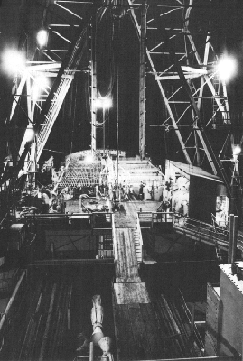
The Glomar Challenger of the Deep Sea Drilling Project, drilling at night.
The early work of the Glomar Challenger was chiefly in the Atlantic Ocean, but in 1969 the ship moved into the Pacific. Scripps expeditions had helped pave the way there, by making detailed surveys of a number of the sites selected for drilling. Scan Expedition in 1969 sailed counter-clockwise around the Pacific, pausing at 33 locations for reflection profiling, magnetometer readings, piston-core samples, heat-flow measurements, and sea-floor photographs. These helped establish the precise location for each
The vessel has gone on around the world and throughout the “seven seas” from the Arctic to the Antarctic and the tropics between. Each leg of its journeys is almost two months long, followed by a short stop in port, allowing a complete crew changeover. A high point in the drilling operation was reached on 25 December 1970, when a wornout drill bit was replaced and re-entered in the same drill hole. This capability has made it possible to drill through the hard chert layers, which seem to be found so commonly throughout the world's oceans.
Preliminary analyses of the cores taken by Glomar Challenger are done aboard ship. “The first analysis is by paleontologists, who determine geologic age. Technicians X-ray cores, determine water content, and measure radio-activity. Then they study a core's composition, grain-size and general mineralogy. Cores are documented photographically, because some properties change in storage. Then the cores are carefully packaged and placed in cold storage.”[50]
Preliminary reports on the cores are published soon after the completion of each leg of the cruise. A year after each leg, the samples become available to qualified researchers for further study. Lamont-Doherty Geological Observatory is the repository for cores from the Atlantic Ocean, the Antarctic area, and the Mediterranean; and Scripps Institution is the repository for cores from the Pacific and Indian oceans, under the curatorship of William R. Riedel. The quantities of cores required building an addition for core storage beside the Deep Sea Drilling building in 1974.
The original drilling contract for 18 months was extended by 30 months, and again by 36 months. Leg 44, “the culmination of over seven successful years of geological exploration,” ended on 30 September 1975, and completed the
The fourth phase of the project commenced on 30 November 1975, as the International Phase of Ocean Drilling (IPOD), the purpose of which is to drill holes deep into the rocks beneath the sea-floor sediments in an attempt to determine their composition, structure, and geologic history, as well as to continue coring in the sediments. International it is, for through the years the member institutions of JOIDES have grown to include: the Bundesanstalt für Geowissenschaften und Rohstoffe, Federal Republic of Germany; the Centre National Pour L'Exploitation des Oceans (CNEXO) of France; the Department of Oceanography, University of Washington; Hawaii Institute of Geophysics of the University of Hawaii; the USSR Academy of Sciences; the Lamont-Doherty Geological Observatory of Columbia University; the National Environmental Research Council (NERC) of the United Kingdom; the Ocean Research Institute of the University of Tokyo; Oregon State University; the Rosenstiel School of Marine and Atmospheric Science of the University of Miami, Florida; Scripps Institution of Oceanography of the University of California at San Diego; Texas A & M University; the University of Rhode Island; and Woods Hole Oceanographic Institution.
To begin the new phase, during 1976 Glomar Challenger traveled more than 20,000 nautical miles, and 44 holes were drilled into the sea floor, to recover more than 1,000 cores. At a site west of Portugal a record penetration of 1,740 meters into the sea floor was attained.
In its eight years of effort, the Deep Sea Drilling Project has retrieved 145,728 feet of sediment (to May 1976). Those columns of sand, silt, volcanic ash, and debris, accumulated from 398 sites in the world's oceans, have “unequivocally established the geological youthfulness of [the oceanic] crust in comparison to most continental rocks and
NOTES
1. Anatomy of an Expedition (New York: McGraw-Hill, 1969), 48. Used with permission of McGraw-Hill Book Co.
2. Ibid., 4.
3. Ibid., 48.
4. Reply to award of Wollaston Medal of the Geological Society of London, Proceedings of the Geological Society of London, No. 1634 (3 October 1966), 140.
5. Scripps Institution Notes, September 1933.
6. Private notes, 15--22 October 1937; SIO Archives.
7. “Terrestrial Topography of Submarine Canyons Revealed by Diving,” Bulletin of the Geological Society of America, Vol. 60 (October 1949), 1599.
8. Ibid.
9. Reply to award of Wollaston Medal of the Geological Society of London, loc. cit., 139.
10. San Diego Union, 23 April 1966.
11. F. P. Shepard, The Earth Beneath the Sea (Baltimore: Johns Hopkins Press, 1959), 210.
12. F. P. Shepard, “Stratigraphic Research That May Pay Off,” Oil and Gas Journal (21 February 1955), 159.
13. In: Francis P. Shepard, Fred B Phleger, and Tjeerd H. van Andel, editors, Recent Sediments, Northwest Gulf of Mexico (Tulsa, Oklahoma: American Association of Petroleum Geologists, 1960), 3.
14. In: Ibid., 365.
15. “Coastal Processes and Long Range Planning,” 8th Annual Conference of Marine Technology Society, Preprints, 1972, 217.
16. Douglas L. Inman and Birchard M. Brush, “The Coastal Challenge,” Science, Vol. 181 (6 July 1973), 21. Copyright 1973 by the American Association for the Advancement of Science.
17. Citation for LL.D. at UCSD, 1965.
18. IMR Annual Report, 1972.
19. Anatomy of an Expedition, 221--22.
20. E. D. Goldberg, “Chemistry in the Oceans,” Oceanography, Washington, D.C., American Association for the Advancement of Science, 1961, 591.
21. Radio message, 1 January 1953.
22. Radio message, 6 January 1953.
23. Letter of 11 December 1952.
24. Letter of 11 December 1952.
25. Letter to the author, 27 November 1974.
26. Anatomy of an Expedition, 170.
27. Letter of 10 January 1953.
28. Radio message, 18 November 1974.
29. Anatomy of an Expedition, 4--5.
30. In Allan Cox, compiler, Plate Tectonics and Geomagnetic Reversals (San Francisco: W. H. Freeman & Co., 1973), 410 and 535--36.
31. Willard Bascom, Hole in the Bottom of the Sea (Garden City, New York: Doubleday, 1961), 47--48. Copyright $ 1961 by Willard Bascom. Reprinted by permission of Doubleday & Company, Inc.
32. Ibid., 30.
33. R. G., “Do Oceanographers Have More Fun?” Science, Vol. 181, No. 4103 (7 September 1973), 926.
34. Willard Bascom, Hole in the Bottom of the Sea (Garden City, New York: Doubleday, 1961), 48.
35. Ibid., 49.
36. D. S. Greenberg, “Mohole: The Project That Went Awry,” Science, Vol. 143, No. 3602 (10 January 1964), 116.
37. Ibid., 118.
38. “High Drama of Bold Thrust Through Ocean Floor,” Life, Vol. 50, No. 15 (14 April 1961), 111. Copyright $ 1961 by John Steinbeck. Originally appeared in Life Magazine. By permission of McIntosh and Otis, Inc.
39. Ibid.
40. Ibid., 122.
41. Letter in Science, Vol. 143, No. 3612 (20 March 1964), 1275. Copyright 1964 by the American Association for the Advancement of Science.
42. News release, 7 March 1962.
43. “Mohole: Aground on Capitol Hill,” Science, Vol. 153, No. 3739 (26 August 1966), 963.
44. “Deep-Sea Drilling for Scientific Purposes: A Decade of Dreams,” Science, Vol. 160, No. 3835 (28 June 1968), 1420. Copyright 1968 by the American Association for the Advancement of Science.
45. Ibid.
46. Letter of 14 December 1964.
47. Draft of proposal to National Science Foundation, 23 June 1965.
48. SIO Annual Report, 1968, 17.
49. “Deep Sea Drilling with D/V Glomar Challenger,” MS of talk for Challenger Expedition Centenary, 13 September 1972, 4.
50. Ibid., 10.
51. “Deep Sea Drilling: Research Lags Exploration,” Science, Vol. 181, No. 4098 (3 August 1973), 428. Copyright 1973 by the American Association for the Advancement of Science.