III. History's
Greatest Fishing Expedition:
The Marine Life Research Program
Sardinops sagax[*]
[*] Formerly Sardinops caerulea, and thus designated throughout most of the sardine study.
— the Pacific sardine, sometimes called the pilchard — is a tasty member of the herring family. It is a glittering dark green to blue above and iridescent silvery below. Only occasionally reaching twelve inches in length, it is a smallish fish to have caused so much furor. But it does seem as if the Pacific sardine since 1945 has spawned more initials than eggs: i.e., MRC, MLR, CalCOFI, DCPG, WWD, IKMT. The search for it poured a great deal of money into studies of California fisheries.The figures are staggering: in the 1936–37 fishing season, 726,000 tons of sardines were hauled into California harbors in wee-daylight hours — one-quarter of the total tonnage of fish caught in the United States that year; in the 1946–47 season, even with more fishermen searching, only 234,000 tons could be found.
Why? Of course, everyone had a pet theory: changing currents were carrying off the eggs; water temperatures were changing; adult sardines were migrating to greener
At stake was the livelihood of three thousand fishermen and one hundred canneries in Monterey Bay, Los Angeles, Newport, and San Diego. So in January of 1947 representatives of the fishing industry called a meeting of experts to look into the problem. To that meeting the Sardine Products Institute sent William C. Moorehead, Irwin Isaacs, David Oliver, and Julian G. Burnette; Montgomery Phister, who acted as chairman, represented the tuna fisheries; Oscar E. Sette and John C. Marr attended from the U.S. Fish and Wildlife Service; Frances N. Clark and Richard Croker represented the California Bureau of Marine Fisheries; Robert C. Miller and Wilbert M. Chapman represented the California Academy of Sciences; and Harald U. Sverdrup attended from Scripps. Sverdrup was essentially nominated by Chapman, who wrote Phister in December 1946: “In regard to a representative from Scripps … Dr. H. U. Sverdrup, Director, is in my opinion the most competent oceanographer now working in the world. … He is the key man in Pacific Oceanography.”[1]
Within a year the California legislature had established the Marine Research Committee (MRC) of nine members, five from the fishing industry, one public representative, one from the California Fish and Game Commission, and two from the California Division of Fish and Game. The legislature also guaranteed $300,000 for the first year of a three-year study to the University of California, to be used by the Scripps Institution (this was increased to $400,000 the next year). The fishermen, through the California Sardine Products Institute, augmented this by persuading the legislature to impose a tax of 50 cents per ton on sardines for four years, to be collected by the
The organizational meetings were not smooth, as each participating group worked within its own restrictions and needs to establish its role in a complex undertaking. Chapman admitted candidly to Don T. Saxby of the California Packing Company after the first MRC meeting: “The whole damned thing is likely to fly apart before it gets started” — and then worked furiously to see that it didn't.
Sverdrup was a vital participant in setting up the study although he had already announced his intention of returning to Norway. He commented at the time that he might not have left Scripps had he known that such an all-encompassing oceanographic project was about to begin.
The following year, 1948, Scripps was represented by its new director, Carl Eckart, at the second meeting of the Marine Research Committee, held in La Jolla, and he was accompanied by colleagues Carl L. Hubbs, Martin W. Johnson, Roger Revelle, John D. Isaacs, and graduate student J. Laurence McHugh. Revelle had just returned to Scripps from his Navy service and was designated as associate director and given charge of the Scripps portion of the sardine project.
Thanks to the groundwork laid by studies that had begun in the 1920s, including those in which Scripps had participated in cooperation with the California Division of Fish and Game (1937) and with the U.S. Fish and Wildlife Service (1938 to 1941) throughout the California Current, the organizations that came to the aid of the sardine fishermen “were able to get to work with little waste motion. They knew what they were after and the best way to get it.” They already knew that “the sardine is a restless and far-traveling creature. When California, Canada, Washington,
But only the larger and older fish drifted far north; their numbers dwindled first, and were not replaced in a succession of poor spawning years. Canneries in Canada, then in Washington and Oregon closed, soon followed by those in San Francisco. Supported by fish from fairly good spawning in 1946 to 1948, Cannery Row in Monterey hung on. But it too was doomed.
The sardine project that began in 1948 was very much a cooperative one. The U.S. Fish and Wildlife Service, through its South Pacific Fishery Investigations, undertook studies on the spawning, survival, and recruitment of sardines, using its ship Black Douglas. The California Division of Fish and Game, which had been studying the slippery sardine for thirty years, set out to determine its availability to fishermen by studies of the animal's abundance, distribution, migration, and behavior, using its ship N.B. Scofield and later also the Yellowfin. The California Academy of Sciences began laboratory studies on the behavior and physiology of sardines, and Stanford University's Hopkins Marine Laboratory joined the project in 1951 to study the oceanography of the Monterey Bay area in detail.
The Scripps Institution — on which we shall concentrate here, with apology to the others — from the beginning was given responsibility for gathering general oceanographic data in the sardine habitat, as well as information on the organic productivity of the ocean. Sverdrup gave the term Marine Life Research program (MLR) to the Scripps part of the project.
There was not space within the walls of the four research and office buildings on the Scripps campus to contain the envisaged project. But the close ties between Scripps and the Navy research groups on Point Loma made it possible to arrange for facilities there. So the Scripps MLR group was first located in Navy barracks buildings at Point Loma in 1948. The personnel were gradually moved onto the Scripps campus as space became available.
A laboratory of the U.S. Fish and Wildlife Service was first located at Stanford University, but in February 1954 Revelle extended an invitation to John C. Marr to move that research group to Scripps, “to facilitate the integration of the California Cooperative Oceanic Fisheries program.” That same summer part of the group moved into the director's house (T-16) at Scripps, and others into facilities at Point Loma, where a branch laboratory of the Fish and Wildlife Service was already located. In 1964 the spectacular Fishery Oceanography Center[*]
[*] Sometimes called the “Fish Hilton” because, Sally Spiess recalls, while it was under construction passing tourists often asked when the new hotel would be open.
was completed on land provided by the university at the north end of the Scripps campus, and the Bureau of Commercial Fisheries of the U.S. Fish and Wildlife Service moved into it. (The building was renamed Southwest Fishery Center in 1970, and the Bureau was renamed the National Marine Fisheries Service, an agency of NOAA, the National Oceanic and Atmospheric Administration.[*][*] When this organization is mentioned throughout this book, its name at the time cited will be used. The building is generally called the Fisheries Building by Scripps people.
)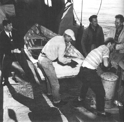
Retrieving the bottom fish-trap, 1950; John D. Isaacs sitting on rail, Lewis W. Kidd second from left.
The statewide research project under the Marine Research Committee was referred to as the California Cooperative Sardine Study until 1953, when it became the California Cooperative Oceanic Fisheries Investigations (at
Thanks to the state's contribution and the Navy's interest in general oceanographic studies, the sardine study could be tackled with a fleet. In addition to the ships of the other participating agencies, Scripps Institution's Horizon and Crest were assigned specifically to MLR, and indeed their conversion to research vessels was mostly accomplished with MRC funds and university money for that purpose. In addition, the Paolina-T and sometimes the E. W. Scripps were used for occasional special investigations or when one of the regulars was laid up.
The plan of attack devised in 1948 (slightly modified in 1950) was a bold one. It was to survey 670,000 square miles of ocean, from the mouth of the Columbia River to halfway down Baja California and extending outward 400 miles. Through this region flowed the California Current, the mass of water from the great clockwise circulation of the North Pacific that moves southeastwardly at a speed of less than half a knot parallel to the American west coast, warming in the sun, until at about 25° north latitude it swings westward to join the North Equatorial Current. The California Current is complicated by countercurrents and eddies, intermittent and permanent, and by regions of upwelling.
To study the region systematically, a grid was laid out by drawing a line roughly parallel to the coast from which right angle lines were drawn at 120-mile intervals. Along
All this was more easily planned on land than carried out at sea, especially during the winter cruises, and the time schedule often had to adapt to nature's whims.
On one early CalCOFI cruise, the U.S. Fish and Wildlife ship, Black Douglas — a former sailing yacht — was called to aid a burning lumber boat in heavy seas. Directed by Coast Guard helicopters, the yacht reached the scene of distress at night, to find that the ship had broken up and its crew were all drifting in two lifeboats. One of the lifeboat occupants was heard to exclaim: “Christ — a goddamned yachat!” In spite of 25-knot winds, the plunging Black Douglas was held steady alongside the first lifeboat, and as waves raised the boat about level with the gunwales, the survivors were yanked onto the deck of the Black Douglas one at a time. The second boat was awash and beginning to founder when finally located, but its wet, cold occupants were quickly pulled aboard the Black Douglas, which cut short its survey to get the rescued back to port.
Results from the monthly cruises began coming in very promptly. “The oceanographic approach to the sardine problem,” said the progress report of 1950, “is the feature which makes the present work unique; it has never been tried on such a scale before anywhere in the world. What — very briefly — the scientists hope to do is to correlate changes in water conditions with sardine spawning, availability, and abundance.”[3]
The talk by the participants was soon of year-classes, upwelling regions, phytoplankton, and weather. Two major centers of spawning were outlined, one near Cedros Island off Baja California, and a larger one off the boundary between California and Baja California. Both were areas of upwelling, separated by an almost barren region. Two other known spawning areas, in the Gulf of California and off southern Baja California, were considered to be outside the sources of the California catch. Water temperatures between 12.5° and 16° C. proved to delimit sardine spawning. There was talk of last year's weather becoming the key to this year's forecast of spawning because of its effect on currents and upwelling. Certain years were found to produce the majority of caught sardines for several years; the year-classes could be readily identified by growth counts on the scales (now the lines of growth on the otoliths, or “ear bones,” are also used). Experiments ashore showed that antibiotics added to sea water greatly increased the hatch of sardine eggs, suggesting that disease might be affecting the numbers. Laboratory tests showed that sardines could be “herded” by electrical currents. The lateral-line system of fishes came under scrutiny. Attempts were made to determine individual races of sardines so that their origin and extent of mingling could be unraveled.
As graduate student J. L. (“Laurie”) McHugh had commented when the project was being established in 1948: “The resources of both the physical oceanography and the recruitment research shore sections will be taxed to the limit in handling the material collected at sea.” Within the first year of the sardine project, the staff of Scripps was increased 42 percent. It was at that time that the Data Collection and Processing Group (DCPG) made its appearance. Their task was to analyze hydrographic data from approximately 1,500 stations each year, quickly enough for the results to be used in planning the next year's program. At
Thanks to the breadth of the sardine project, MLR money supported some projects and personnel in almost every aspect of ocean studies at Scripps, but chiefly, of course, in biology, physical oceanography, and instrumentation, beyond the considerable costs of running the ships.
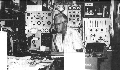
The lifeline to the ships: “Nick” Carter in the campus radio shack, in the mid-1960s. Photo by J. D. Frautschy.
WWD made its appearance too — not an abbreviation in this case, but the call letters of the lifeline to the ships, the radio station. Having learned the usefulness of steady radio communication through the work for UCDWR by the E. W. Scripps, the institution wanted its own voice between home base and the fleet of ships running the station grid. Persistent correspondence led to permission in 1948 for the institution to use the frequencies of the U.S. Fish and Wildlife Service for MLR work and Navy frequencies for other traffic. The Fish and Wildlife Service finally persuaded the Interdepartmental Radio Advisory Committee to assign them a station for the sardine project, to be operated by Scripps personnel, at first in a temporary building south of Scripps Laboratory (where it interfered with campus telephone calls whenever it was transmitting). Frank Berberich opened “Willie Willie Dog” in August 1949, and the voice at first was feeble, limited by edict to 125 watts on the 500-watt Navy equipment obtained, while it reported on storms and new fishes and sometimes troubles at sea, but it did speed the work and was a comfort to those ashore. In 1952 WWD was relocated on the hilltop eastward of the main
The radio shack has been renovated in the 1970s, under the leadership of Donal C. Crouch. For many years it was the domain of Arthur B. (“Nick”) Carter — “a professional of vast experience with the enthusiasm of the most dedicated young ‘ham’ operator.” In those days the quarters were cluttered and noisy, with fragments of code and garbled voices drowning each other out, bells and telephones ringing, and teletype clattering. From the apparent chaos Carter would emerge with a bluff, hearty greeting for a visitor that said you were the one person he most wanted to see. Along with the greeting came an offer of thick coffee in a thick mug. After many years, Carter still marveled at the thousands of miles of ocean that his key could span in an instant and draw a response, so that somehow the ocean seemed smaller in that friendly room. In Navy tradition, the typed messages come out of the radio station in cryptic sentences in block letters, and with little punctuation. The spelling is sometimes startling, but excusable when one takes into account the fading of distant transmission and the technical terms used — polysyllabic scientific names of biological specimens, chemical terms, geological descriptions, names and numbers of parts for gears and engines and winches.
The first years of the sardine project were, of necessity, devoted to defining the problem and collecting data. The
There were special cruises as well. In 1955, MLR, along with other groups at Scripps, participated in “the most ambitious oceanographic survey ever attempted” to that time: Norpac (for North Pacific) Expedition. A cooperative synoptic survey of the Pacific Ocean north of 20° latitude was first proposed by Joseph L. Reid, Jr., in 1953, and it grew to include 19 research vessels of 14 institutions from the United States, Japan, and Canada. From July to September, 1,002 hydrographic stations were occupied, and more than 2,000 plankton samples were gathered, for an almost simultaneous picture of the vast region from Acapulco to Alaska and across to Japan. August had been selected as the time least likely to be disturbed by weather, and indeed the “expeditions were remarkably free from bad weather and breakdowns,” reported coordinator Reid,[5] who also recalls that the Scripps ships were among his headaches. Horizon sailed for Norpac on 3 August 1955, Spencer F. Baird on 8 August, and the newly acquired Stranger finally left on 9 August after delays for repairs. From home base Reid monitored messages requesting permission to return because of minor problems, which he firmly denied, so the ships sailed on. Two of the participating Japanese ships rode out typhoons “but pressed on to complete their planned work.” It appeared to one awed reporter that “the ships are measuring anything that might be pertinent to a better understanding of the mysterious sea,”[6] but the observations and collections were actually of temperature, salinity, dissolved-oxygen content, inorganic phosphate-phosphorus,
In 1957, the Marine Research Committee paused to see what it had done in a decade. A special committee summarized the accomplishments, which included: defining four spawning areas of sardines; developing methods of estimating numbers of eggs, larvae, juvenile, and adult sardines; obtaining information on north-south migrations; studying behavior patterns; determining that common nutrients are not limiting to phytoplankton; defining zooplankton areas; accumulating temperature, salinity, oxygen, and phosphate data; and gathering information on the abundance and location of the eggs, larvae, and adults of anchovy, jack mackerel, Pacific mackerel, saury, and hake.
The special committee, which consisted of John D. Isaacs of Scripps, John Radovich of California Fish and Game, and chairman John C. Marr of the U.S. Fish and Wildlife Service, concluded that further studies of the sardine populations and the oceanography of the spawning region should be continued. CalCOFI, they felt, had “made real contributions toward a better understanding of the fisheries but [lacked] effective coordination.”[7] In a reorganization the members of the “three-Johns committee” became the governing technical committee and Garth I. Murphy was appointed CalCOFI coordinator in 1958 (until 1965). John Isaacs also became in 1958 the director of the MLR program at Scripps. Revelle had included the direction of MLR among his duties as director of Scripps, but various people (for example, Paul L. Horrer) had handled the routine running of the project for several years.
John Dove Isaacs — the big man with the beatific smile and courtly air, distinguished with and by white hair and beard — was the guiding hand of MLR until late 1974, when Joseph L. Reid, Jr., became director of MLR and Isaacs continued with the Institute of Marine Resources (chapter 6). If one were to recommend a training course for a future oceanographer, it could well copy Isaac's. Being a bit of a maverick helps, as does a love of literature and a keen interest in questioning nature. Isaacs has these. He once described himself — accurately — as “a naive, enthusiastic sort of person.”[8] Born in Spokane, Washington, in 1913, he began in oceanography as a commercial fisherman, until his boat tangled with a jetty in the Columbia River and he had to swim ashore. With Willard Bascom during World War II, Isaacs tested crashing breakers and measured beaches in DUKWs and other landing craft until the Coast Guard concluded that it was too dangerous. He graduated in engineering at Berkeley in 1944, worked on wave refraction with Sverdrup and Walter H. Munk, and joined Revelle in Operation Crossroads in 1946 (see chapter 15). Isaacs began at Scripps as an associate oceanographer, at Revelle's invitation in 1948, when the MLR program was just beginning. By 1961 he had become a professor of oceanography. Isaacs is phenomenal in proposing ingenious solutions to old problems. His motto may be “Why not?” And indeed, he is often right.
Considering Isaacs's participation in the special committee of 1957, it is surprising that, in summarizing the results of the first decade, more emphasis was not placed on the major contribution of CalCOFI in developing new instruments for use at sea. The classics of marine biological collecting were invented, tested, and modified during the early years of the California sardine program, many of them in the Scripps unit called Special Developments, headed by Isaacs and James M. Snodgrass.
Equipment at sea is the oceanographers' greatest headache. Of things put over the side, some refuse to go down and others refuse to come up. Towed items flutter to the surface, overhead balloons dive into the waves. Cables kink, winches jam — and suddenly the air turns blue. But, there has to be a way. …
Sam Hinton pointed out one of the problems faced by inventors in the early days of CalCOFI: “A good part of the area under consideration is stormy and rough, and the devisors of new equipment aim for a product that can be operated by a seasick technician who must hold on to a stanchion with both feet and one hand while doing his work!”[9] Help was already on the way; James Snodgrass commented in 1949 that “the ability of a man to do competent work at sea is tremendously improved with the use of … the new motion-sickness drug ‘Dramamine.’ ”[10] Sir Edward Bullard once called seasick pills “probably the greatest scientific contribution of the twentieth century to oceanography.”[11]
On the CalCOFI cruises, plankton samplers were not catching the fleetest of the animals, the ones that darted from the disturbance of the towed cable away from the lagging net. So by 1950 the high-speed plankton collector was devised, with a spherical cable clamp that allowed the net to project forward of the point of attachment. A depthflow meter, which could draw a continuous record of the depth and flow of water through the net, was designed to use with the collector. Also, for underway sampling, a bronze depressor was built to hold the towed cable and collecting equipment steadily and uniformly beneath the surface. But strained cables can snap, so a hydraulic dynamometer was added to measure cable stress.
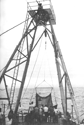
Bringing aboard the Isaacs-Kidd Midwater Trawl, Transpac Expedition, 1953.
The floating fish-larvae trap was another early invention; this was an inverted pyramid of wire mesh, pierced by
California Fish and Game researchers took advantage of equipment developed for wartime — a sonar set and recording echo-sounder — to try locating schools of fish. Although the equipment was considered bulky and expensive and required a trained operator, early tests proved that it could indeed locate schools up to 800 yards away in depths beyond 50 fathoms. The goal was to expand sardine fishing hours, as the custom was to seek the schools only on moonless nights when flashes of phosphorescence betrayed them.
In 1951 another of oceanography's classical tools was being tested, and proving to be a valuable means of exploring ocean depths: the Isaacs-Kidd midwater trawl (IKMT). Although surface fishes and plankton had been regularly collected previously with surface nets, as had some bottom-dwelling fishes and invertebrates with bottom trawls, the vast middle area had only occasionally yielded specimens to science, more by accident than design, and never in the Pacific Ocean. The deep scattering layer that troubled the physicists on their echo-sounders during the war would continue to baffle biologists until a means could be designed to collect within it.
John Isaacs and Lewis W. Kidd took on the design problem, with the experienced advice of Carl L. Hubbs. The trawl consisted of “a net of special design attached to a wide, V-shaped, rigid, diving vane. The vane keeps the
Early tests delighted Hubbs. From the Horizon on Northern Holiday Expedition in August 1951, Isaacs queried by radio:
Took a Macropinna-like fish at 1100 meters in 2400 fathoms X Small fins and entirely flat belly with forward projecting foot suggesting attachment a-la remora X Shall I keep him? X He is not very large X Hauls medium to excellent.
Hubbs replied: “Bring fish back or don't come back yourself.” A few days later he continued:
Macropinna-like fish apparently Opisthoproctus / New for Pacific / One of rarest and strangest types / Two species in Atlantic / Other captures obviously unusual and exciting / Wish I could see them come in / Good luck.
Apart from the novelty of the new species of midwater fishes, all the other common fishes of the sardine region were also under study in the program. For some of the fishes were known to be predators of sardine eggs and young, and others were obviously competitors. There was hope, too, of encouraging other fisheries, particularly the northern anchovy, Engraulis mordax, found in similar numbers and sites as the sardine. The fishermen had little choice, as sardine spawning continued at a low level, and in 1952 the combined catch of “substitute sardines” — anchovy, jack mackerel, and Pacific mackerel — exceeded that of sardines. The tax for research of 50 cents a ton was raised to one dollar and was imposed on those fisheries
More than fishes were under scrutiny. To study the countercurrents along the coast, Paul L. Horrer began a drift-bottle project in 1954. Commercial salad dressing bottles ballasted with sand were released on each CalCOFI station every month in the early years, usually twelve bottles on each station. A red postcard enclosed in the bottle explained in English and in Spanish the purpose of the study and requested the finder to send to Scripps the place, date, time of finding, and finder's name and address. Only a small percentage was returned, most of them released not more than 20 miles from shore. But from these returns Richard A. Schwartzlose was able to define the Davidson Countercurrent, 50 miles wide, from central California north to British Columbia, that began in the fall months, built up to speeds of 0.5 to 0.9 knots for several hundred miles, and disappeared in the spring. Elsewhere, he found short countercurrents and intermittent eddies at irregular times. Drift-bottle releases have been continued. Recoveries vary from zero to 23 percent (average 3.4), from points as distant as Alaska and Acapulco, and in 1971 one was picked up on the island of Hawaii.
The second decade of CalCOFI produced preliminary findings on the region that it called its own, and opened doors to speculation. As John Isaacs noted in a meeting of the MRC, as each question was answered, new ones arose.[13] But questions were being answered, in a multitude of reports, scientific papers, and student dissertations, and in that second decade a new philosophy was emerging in MLR.
Nature stepped in to help — or confound — the scientists in 1957, simply by warming the ocean. Not much, only 2° to 4° C. But — “Hawaii had its first recorded typhoon; the seabird-killing El Niño visited the Peruvian Coast; the
Suddenly, off California, sport fishermen were catching more bonito, yellowtail, barracuda, skipjack, and dolphin-fish than ever before recorded, and farther north. Salmon trollers were catching white seabass; marlin and sailfish were reported, and swordfish were caught off Monterey Bay. Green sea turtles were seen off the Farallon Islands, and many hammerhead sharks were sighted off California beaches.
And the sardines? They moved northward, spawned farther north (but not in greater quantity), and in the 1958–59 season were caught in the greatest numbers since 1951:102,000 tons, vs. 22,000 tons in 1957–58.
Because of the unusual conditions throughout the Pacific Ocean that year, Scripps hosted a symposium on “The Changing Pacific Ocean in 1957 and 1958” at Rancho Santa Fe in June of 1958. Attending were physical, chemical, geophysical, and biological oceanographers, fisheries personnel, meteorologists, and an astrophysicist. They came from east coast and west coast, and one came from Japan. For three days they talked of warmed islands and beaches and shifting currents and fishes, until even expert-in-meteorology Jerome Namias expressed it for all: “It is certainly much more complex than I ever dreamed.”[15]
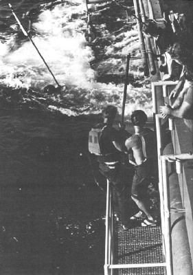
Retrieving a free-vehicle current meter from the Melville on Benthiface Expedition, 1973. Photo by Tom Walsh.
Symposium editors Oscar E. Sette and John Isaacs summarized:
It appears to the Editors that one of the most valuable results of the Symposium is to have pointed out clearly and unequivocally, and from a wide range of evidence, that locally observed changes in ocean conditions, marine fauna, fisheries success, weather, etc., are often the demonstrable result of processes
― 65 ―acting over vast areas. In the case of local Pacific conditions, the changes obviously often are only a part of changes involving the entire North Pacific if not the entire Pacific or the entire planet.It appears that this realization should emancipate many provincial marine investigations and stimulate much thought and inquiry into these vast and critical events that so profoundly influence the local areas of the Pacific.
This is to say, for example, that a basic understanding and subsequent basic forecasting of the fluctuations of a coastal fishery probably can be best achieved by a thoughtfully limited study of the entire ocean, in addition to concentrated concern with the immediate area of the fishery.[16]
The symposium marked a turning point in MLR, carrying its scope beyond the California Current to all of the North Pacific Ocean. CalCOFI in 1960 redefined its objectives:
To acquire knowledge and understanding of the factors governing the abundance, distribution, and variation of the pelagic marine fishes. The oceanographic and biological factors affecting the sardine and its ecological associates in the California Current System will be given research emphasis. It is the ultimate aim of the investigations to obtain an understanding sufficient to predict, thus permitting efficient utilization of the species, and perhaps manipulation of the population.[17]
In line with its broadened goals, the Marine Research Committee adopted the system of awarding contracts to special projects submitted to it by the participating agencies,
The old ships were showing signs of wear. In fact, MLR was an important contributor to wearing out the Crest, the Paolina-T, the Horizon, the Stranger, and the Orca. So, also in 1961, a new ship entered the program, when Scripps acquired a 180-foot light-freight vessel that had previously been operated by the Army Transportation Corps. Following an old tradition, the ship's new name was selected through a contest at Scripps: Alexander Agassiz,[*]
[*] See list of Scripps ships in chapter 14.
in memory of one of Scripps Institution's first ships as well as in honor of the noted oceanographer who had visited the La Jolla marine station in 1905 and had contributed to its library and its morale. Through funds provided by the Regents of the University of California, the Agassiz was outfitted especially for the CalCOFI program, with laboratories and enough deck space for handling the bulky mid-water trawl and other collecting gear, and with glass-covered viewing ports below the waterline.Having acquired many years of oceanographic basic data — in “warm years, cold years, monotonous years, years with strong countercurrents, years with invasion of tropical waters, etc.” — MLR could at last turn to “thoughtful studies of the samples and data already obtained … and
The sardine, which had created CalCOFI and its progeny, was, after all, “a rather minor part of the biomass … like the gold of California, a conspicuous, valuable, easily-harvested element in the midst of less-conspicuous riches of far greater potentialities but requiring painstaking development.”[19]
The phenomenally high catches of sardines during the 1920s and 1930s were historically the result of a major propaganda campaign during the first World War to eat more fish (Ritter had helped on that), at a time when sardines happened to be plentiful, followed by an artificially created market for that same “inexhaustible” resource for fish meal and oil. “What is done with a resource,” pointed out Frances N. Clark and John C. Marr, “is essentially governed by the needs or desires of Man and, in a sense, has little or no connection with the resource per se.”[20] Sardines were caught and canned in tomato sauce originally because it was patriotic — and later because thirty thousand people made their living that way.
But CalCOFI's studies showed that other fishes can gain ascendancy over the sardine, especially the northern anchovy, which appears to have a spawning advantage at lower ocean temperatures, as in the remarkably uniform decade from 1948 to 1957. The larvae of the anchovy, which also spawns farther north than the sardine, also are more likely to be maintained within the California Current and not carried off to unfavorable climes. In 1951 anchovy larvae outnumbered sardine larvae in net hauls on CalCOFI cruises by three to one, but in eight years this had leaped to 45 to one.
The sardine, concluded CalCOFI researchers, “can prosper when there is much variation in the environment, but … under steady conditions, or at least under steady
What may have been the final chapter of the sardine story — but not of the MLR story — came out in the latter 1960s. In an enclosed anaerobic basin off Santa Barbara, cores were drilled through the undisturbed accumulation of sediments that represented a record covering one thousand years. From those cores, Andrew Soutar identified and counted the numbers of fish scales from Pacific sardine, northern anchovy, and Pacific hake, which together constituted 80 percent of all fish scales. The hake, Merluccius productus, already known to be a major component of the biomass, proved to be consistently the most common fish, followed by the anchovy; both were much more uniform in numbers throughout the centuries than was the sardine, which fluctuated through highs and lows. But only once previously, about 800 years ago, did the core record indicate an abundance of sardines like that of the 1920s and 1930s, when California fishermen found their pot of gold.
To adapt to the changing populations, the fishermen changed their ways and, for example, in 1961 landed one million pounds of hake — to feed to mink, to produce fur coats!
Throughout the years, all the varied aspects of the original CalCOFI program continued and expanded. DCPG constantly improved its methods of processing hydrographic data and became the model for all other oceanographic laboratories and for the National Oceanographic Data Center, a credit to the meticulousness of Hans Klein and his training program for technicians. Historical studies were begun, to find documents and records that pertained to
More sophisticated instruments were developed, especially for extreme depths, including the whole family of free-vehicle equipment. The key to this series was simply a link made of magnesium, which, as John Isaacs had noted on 7 April 1947 after conducting laboratory tests, held promise as a release mechanism, as magnesium is corroded by electrolysis in seawater.
Lew Kidd and I [wrote Isaacs in 1967] first worked on autonomous free-fall instruments at Scripps in 1949. Our first model bore a weak but effective light, a piece of yellow phosphorus in a “tea egg” on the mast (this spontaneously ignited after emergence and produced clouds of smoke), a five gallon can of gasoline for buoyancy, a magnesium link timer, and an aluminum mast. Operating around the Channel Islands of Southern California, we had very poor success in retrieval because of the many small boats that also showed masts, lights, and smoke.[23]
One of the early MLR free-vehicle units was a fish trap designed by Isaacs and George B. Schick and put into use in 1959. This device, the benthic trap, is weighted with ballast, and dropped to the sea floor; a gasoline-filled float raises the unit to the surface when the magnesium link on the weight has been corroded through. The trap has proved to be a very effective means of gathering denizens of the deep. For example, Carl L. Hubbs has obtained enough hagfish with free-vehicle traps to identify several new species from the Pacific coast. Hubbs also urged the addition of setlines to the device, by which a number of deep-water fishes have been collected.
By 1966 George Schick and Meredith Sessions had developed the first free-falling camera system, which on its first testing snapped photographs at fifteen-minute intervals down to 3,000 meters. The camera ballast weight carried frozen mackerel to attract potential photogenic models, and suddenly the presumably barren depths proved well populated. MLR's deep-sea cameras have been routinely used down to 7,000 meters, beyond which special housing is necessary because of the extreme pressure. “The thousands of pictures make it clear [wrote Isaacs and Schwartzlose] that much of the deep-sea floor teems with numerous species of scavengers: vigorous invertebrates and fishes, including some gigantic sharks, that are supported by a marine food web whose extent and complexity is only beginning to be perceived.”[24] In the photos have appeared some undescribed deep-sea species and some unexpected ones, such as Greenland sharks, usually found in Arctic waters but caught by the camera in cold depths off Baja California. Sablefish and tanner crabs showed up in sufficient numbers from 600 to 2,000 meters to represent potential large new fisheries.
When the bait and camera reach the sea floor, the authors continue:
Usually the number of fish gathered around the bait increases slowly, reaching a maximum after a few hours. Often the scene develops into one of furious activity, with several species of fish competing for the bait, thrashing and tearing at it and sometimes attacking one another. Shrimps, brittle stars, amphipods and other invertebrates encroach on the melee. In almost half of the sequences from drops down to 2,000 meters the party ends abruptly after three to eight hours, when some creature, usually a large shark, moves in, frightens off the other fish and consumes the
― 71 ―bulk of the bait. In any case the time comes when most of the bait has been eaten. The fish depart, and slowly crabs, sea urchins, snails and other such creatures arrive to complete the task of sanitizing the sea floor.[25]
MLR engineers have also developed a free-vehicle sediment trap, for determining the rate at which surface debris accumulates on the sea floor, and deep-sea current meters. The latter have been used to trace the flow of cold Antarctic bottom water into the Pacific, to measure the flow of water through Drake Passage from the Pacific to the Atlantic, to determine that a slow current flows along the bottom of the Tonga Trench, and in various other deep-water sites. The recovery rate of these meters has been exceptionally high, especially for finicky oceanographic instrumentation. Jery B. Graham, for example, who has methodically readied and lowered at least one hundred current meters, has recovered all except one of them. Various release mechanisms have been developed for the several kinds of free-vehicle equipment, as have been a variety of devices for signaling to and from the surfaced item for retrieving it.[*]
[*] A story, perhaps apocryphal, recounts that someone from Scripps dropped a free-vehicle instrument into Lake Tahoe on a research project — and after waiting long after the release time suddenly recalled that fresh water does not corrode magnesium.
Equipment development continues apace; for example, in the early 1970s:
Daniel M. Brown has developed four new systems for sampling marine organisms. One is a conversion of the Isaacs-Kidd mid-water trawl into an opening-closing net. Another is a closing, vertically towed net
― 72 ―built to reduce the handling and “scarring” problems of this style of sampling. The third is a trap that can capture live fish at great depths, hold them in their own cold water, and keep them under pressure. The fourth is a low-cost free-vehicle, drop-camera system developed to photograph schools of fish detected on sonar, thus providing a simplified method of identifying pelagic fish stocks.[26]
Plankton studies have long been an intensive part of CalCOFI studies. Isaacs noted in 1969 that “there is now in the archives at Scripps the greatest and most complete plankton collection of any area in the world.”[27] Since 1967, Abraham Fleminger has been curator of this vast assemblage — more than 60,000 samples. As the collections have grown, taxonomic studies of individual groups have been completed: calanoid copepods by Fleminger; chaetognaths by Angeles Alvariño; Euphausiacea by Edward M. Brinton; pelagic molluscs by John A. McGowan; and Thaliacea by Leo D. Berner.
For many years the spiritual leader of the researchers on plankton was Martin W. Johnson, who became a staff member at Scripps in 1934 and continued to emeritus status in 1962. Besides his wartime work on identifying snapping shrimp cracklings and other underwater noises and on determining that the deep scattering layer was composed of living creatures (see chapter 2), Johnson became interested in identifying water masses through the composition of the plankton organisms within them. These studies were especially cited by the National Academy of Sciences in 1959, when it awarded to Johnson the Alexander Agassiz medal. His particular specialty has long been the larvae of spiny lobsters and of slipper lobsters; through the years he has identified and described the pelagic larvae of all species of lobsters known from the Pacific coast and Hawaii — no
John A. McGowan joined the Scripps staff immediately after receiving his Ph.D. at the institution in 1960. Born in Oshkosh, Wisconsin, McGowan had received his bachelor's and master's degrees at Oregon State College. For three years beginning in 1956 McGowan was staff marine biologist for the Trust Territory of the Pacific Islands, headquartered in Palau. Under the Marine Life Research program, he has been especially interested in gaining more precision in plankton sampling, in order to determine the detailed structure of plankton communities in time and space. Daniel M. Brown and McGowan designed the Opening and Closing Paired Zooplankton Net, nicknamed the “bongo” net. It consists of two parallel nets (that resemble bongo drums) with no bridle, towline, or cable ahead of them that might warn fleet creatures of the approaching net. The nets can also be opened and closed at any desired depth, instead of the former custom of hauling nets from the start of the tow to the surface. From such precise sampling, McGowan and colleagues were able to conclude that communities of animals are found together in a particular water mass, and that boundaries can be drawn for the animal populations just as they can for the separate water masses. By using a drogue that performed diurnal vertical migrations, McGowan and his coworkers were able to sample for the species structure of individual plankton masses and simultaneously for the physical characteristics of the surrounding water.
The region of intensive study during the 1970s, by McGowan and colleagues — including Elizabeth (“Pooh”) Venrick, Lanna Cheng (Lewin), and members of the Food Chain Research Group — has been the North Pacific Central
Edward M. Brinton, also a Scripps alumnus, joined the staff in 1959 and has also participated in detailed plankton studies, with emphasis on euphausiid and sergestid crustaceans. Euphausiids — also known as “krill” — are a significant food source in the ocean, the chief food of the baleen whales and of various commercially valuable fishes. Brinton's group has devoted considerable effort to the taxonomy of these crustaceans, including the identification of the multi-formed larval and adolescent stages. Brinton has also analyzed plankton samples from two expeditions, Piquero in 1969 and Aries in 1971, that were carried out in the same area of the South Pacific at opposite seasons. Using multiple sets of collecting nets, Brinton and colleagues gathered samples from as many as ten depths simultaneously to determine the vertical distribution of plankton within and along the equatorial currents. In the Peru-Chile Current, Brinton found that the “production of life in the surface waters is so great that, upon its dying, sinking, and then decomposing, oxygen is almost completely depleted from a layer beneath the surface.”[29] A localized group of species has developed in this area that is adapted to migrate up and down through the almost anaerobic layer.
Another aspect of plankton studies has been carried out
A new form of summary publication appeared in 1963: the first volume of the CalCOFI Atlas series, under the direction of Hans Klein, “a man of dignity and loyalty, intensely proud of his association with Scripps,”[30] who headed DCPG from 1956 to 1968. The first atlas presented temperature and salinity data for a depth of ten meters for the California Current region, on the data from 1950 to 1959. Others in the series, which in 1976 had reached 24 volumes, presented summaries on the distribution of several zooplankton groups, on the distribution of the larvae of a number of species of fishes, on geostrophic flow, on zooplankton biomass and volume, on temperatures and salinities, on drift-bottle results, and on seasonal sea-level pressure patterns.
Thanks to the fickle sardine, the CalCOFI committee has felt justified in declaring that “the oceanography, the biology of the California Current system, and the variations in these are now the best documented and best understood of any oceanic area in the world.”[31]
To understand that current in its entirety, it seemed appropriate to look even farther, to the forces that push and shape the California Current that in turn determines where the plankton will be that in turn become food for all the living resources from California waters. MLR since the mid-1960s has enlarged its scope to include studies of
Sophisticated equipment and many years of experience and observations — as well as ingenuity — are bringing us closer to real answers to the fluctuations in the weather and in the ocean, to which the glittering sardine responds without knowing why.
NOTES
1. Letter in MLR archives.
2. CalCOFI Progress Report (1950), Introduction, 7–8.
3. Ibid., 5.
4. Letter in MLR archives.
5. Oceanic Observations of the Pacific: 1955, The NORPAC Data (Berkeley and Tokyo: University of California Press and University of Tokyo Press, 1960), Introduction.
6. New York Herald Tribune, 25 August 1955.
7. Minutes of Marine Research Committee, 19 December 1957.
8. CalCOFI Reports, Vol. VII (1 January 1960), 26.
9. News release, 10 January 1950.
10. Letter to Andrew R. Boone, 14 July 1949.
11. Quoted in T. F. Gaskell, Under the Deep Oceans (London: Eyre and Spottiswoode, 1960), 73.
12. John D. Isaacs and Lewis W. Kidd, “A Midwater Trawl,” SIO Reference 51–51 (November 1951), ii.
13. Minutes of MRC, 4 October 1960.
14. CalCOFI Reports, Vol. VII (1 January 1960), 21.
15. Ibid., 211.
16. Ibid., 214–15.
17. Minutes of MRC, 4 October 1960.
18. CalCOFI Reports, Vol. IX (1 January 1962), 9.
19. CalCOFI Reports, Vol. VIII (1 January 1961), 7–8.
20. CalCOFI Progress Report, 1 July 1953 to 31 March 1955, 13.
21. CalCOFI Reports, Vol. VIII (1 January 1961), 7.
22. Los Angeles Times, 22 June 1949.
23. “Remarks on Some Present and Future Buoy Developments,” Transactions, Second International Buoy Technology Symposium, Marine Technology Society (1967), 504.
24. “Active Animals of the Deep-sea Floor,” Scientific American, Vol. 233 (October 1975), 85.
25. Ibid., 86.
26. SIO Annual Report, 1974, 29.
27. CalCOFI Reports, Vol. XIII (1 January 1969), 8.
28. CalCOFI Reports, Vol. XVII (1 October 1974), 15.
29. SIO Annual Report, 1970, 14.
30. CalCOFI Atlas 17 (June 1972), iii.
31. CalCOFI Reports, Vol. XI (1 January 1967), 5.