Chapter II
Enslavement Traditions: Persecution and Flight
"They [Nguo Ntuni] came wearing red cloth and curved swords, and there was no end to how cruel they could be. . . . The final task they set . . . was to make a spear so long its point would touch the sky."[1]
M'Ikieni M'Itimbere
Murungi age-set Age
Early eighties
The most beloved and widely known among Meru oral traditions are those concerned with a people known only as the Nguo Ntuni (red clothes). They are recalled as the most powerful of those tribes neighboring Mbwaa and the only group without a single identifiable location. Rather, they lived within small log stockades ("walled villages") that were scattered at various points on the mainland and used as trading centers. The Nguo Ntuni also sailed, and islanders could see their ships pass ("like clouds") across their eastern horizon, disappearing in the direction of the rising sun.
Around 1700 ("when the men of Ntangi were warriors"), a group of Nguo Ntuni attacked Mbwaa. They appeared in a large sailing vessel that landed on the mainland, opposite the island's western shore. The ship's crew then crossed the intervening waters on crude wooden rafts.
Nguo Ntuni: The Invaders
The invaders are remembered as taller and lighter skinned than the islanders. They wore a single red cloth tied around their waists and at one shoulder, and bound another around their heads. Each carried a short sword of the scimitar type, of which the blade curved backward and only the outer edge was honed. They also carried several guns.
Informants differ on the nature of the conquest. Some state that there was a single battle in which the use of the guns proved decisive. Others believe that the islanders did not resist. All agree, however, that the
Nguo Ntuni victory was complete and that the pre-Meru entered a period of enslavement.
The Nguo Ntuni proved harsh and efficient masters. They seized existing food and livestock, and then set the islanders to work producing more. To prevent their escape, recalcitrant workers were pierced behind an ankle. A rope was passed through the opening and secured to a post in the ground. Males were also forced to "gather" ivory—whether from their existing stocks or by hunting is unclear—and carry it across the channel to a separate group of Nguo Ntuni on the mainland.
The invaders also brought certain innovations that were considered blessings. One was a type of plow that replaced the islanders' simple digging stick. More significant, the newcomers introduced an iron fish trap, one large enough to entrap the fish that had previously broken their wooden hooks. Finally, a new kind of cow ("like a buffalo, without a hump") was brought onto the island, and the defeated were set to tending what were now their masters' herds.
Contemporary informants refer unanimously to this period in their history as one of outright slavery. More likely, it consisted of an initial theft of whatever wealth was available, followed by the development of some form of tribute relationship. This hypothesis would seem to be substantiated by Nguo Ntuni behavior after the conquest. Evidently, some or all of them returned to the mainland, reappearing only at certain seasons ("they had their times"). They normally lived on the mainland behind a log stockade. They had other slaves whom they used to cultivate their mainland gardens but spoke to them in a language that no islander could understand.
Who Were The Nguo Ntuni?
The Nguo Ntuni were most likely East African coastal Arabs, descendants of one of the earlier Middle Eastern migrant groups that had formed numerous commercial communities along the Kenya-Somalia coast. Descriptions of their appearance, clothes, and weapons tend to confirm this identification, as do the informants themselves.
A variant of the Nguo Ntuni tradition suggests non-African invaders. In some versions the conquerors are recalled as "Nguruntune," a pejorative with the implication of "red legs."[2] In the past, light-skinned non-Africans such as Europeans, Persians, and Arabs were commonly perceived as red by Bantu-speaking peoples. Thus, if the tradition refers
to the invaders' skin color rather than their clothes, they may well have been non-African.
Linguistic data also provide clues to the invaders' origin. Informants state that the Nguo Ntuni did not speak Swahili yet could be quickly understood. In fact subsequent traditions recount considerable and often heated dialogue between victors and vanquished. This would seem to eliminate the possibility of an invading group that had sailed from distant regions in favor of one of the more local Arab communities that had settled adjoining island or mainland areas.
Nor would such a community have spoken Swahili. That language, since its inception, has always been a lingua franca, rather than a mother tongue, for many coastal peoples, including those of the Lamu Archipelago of which Manda Island (Mbwaa) is a part. It seems probable, therefore, that the invaders spoke a seventeenth-century variant of the dialect (Ki-Amu) then current in the archipelago, which islanders could understand.
Further support for this contention can be drawn from examination of a related Meru tradition that deals with the Mbwaa period ("when the men of Ntangi . . ."), the story of Mukuna Ruku. This tradition appears within the oral histories of the Gikuyu, Embu, and Meru peoples of Mount Kenya, as well as the adjacent Tharaka, Kamba, and Mbeere. The Meru version, however, appears at two widely separated points of tribal history. During the first (Ntangi age-set, ca. 1700), Mukuna Ruku is described as having lived behind a log stockade that the Nguo Ntuni had constructed on the mainland. He had red skin, which he kept covered at all times with cloth, a fact the islanders found odd.
Mukuna Ruku was also unique in that he never appeared or spoke to the islanders. Instead, men of Mbwaa who appeared at the barricade with heavy loads of ivory were instructed to drop them at the narrow gate. Then they beat upon a piece of wood that hung nearby (gakuna ruku: to beat a piece of wood). Having drawn attention, they withdrew from view.
The gate then opened, and Mukuna Ruku took the tusks, leaving prescribed amounts of beads in exchange ("placing tucu, marutia , and ngambi [beads] into the horn"). He beat the wood once more to attract the islanders' attention, then left. No word was spoken on either side, and the islanders, never able to learn the identity of the figure within the stockade, may gradually have raised it first to literary and then mythological stature.[3]
The figure of Mukuna Ruku disappears, however, from the traditions of subsequent age-sets. The story recurs only in narrations that deal with the mid-nineteenth century, when interest in ivory was reawakened by the initial appearance of Kamba traders in the Meru region. Men of that era (Kubai age-set) inquired as to where the tusks would be taken. The Kamba replied with a story similar to that which the Meru themselves had brought from Mbwaa. In this version the tusks were taken, by middlemen recalled as the Baruku, once again to Mukuna (or Mukuno) Ruku, this time explicitly identified as an Arab trader who had come from the direction of the sunrise and who required the "silent" trading system to do business.
It seems probable that the Meru, recalling their own experiences with "silent" traders, simply incorporated the Kamba tradition into their own body of folklore, where it has overlaid and perhaps distorted the earlier Mbwaa version. Nonetheless, the fact that the nineteenth-century accounts explicitly identify the figure of this silent trader with the Arabs makes it possible to identify the earlier pre-Meru trading figure with them as well.
The ultimate check on the validity of Meru tradition, of course, is the degree to which it corresponds with other historical data for the area. For instance, informants are unable to identify significant Arab towns, either on the mainland or adjacent islands. At first glance this inability seems hard to understand, in view of the proximity of Lamu, Pate, and other Arabized trading centers, each of which should greatly have influenced their immediate African neighbors. However, the period immediately prior to that in which Meru history begins (1770) was marked by continual conflict between the Arabized populations of all archipelago principalities and the Portuguese, struggles in which the latter were usually successful.
The rulers of Pate, to select only one example, revolted unsuccessfully against Portuguese domination in 1637, 1660, 1678–1679, and 1686–1688. The conflict of 1678–1679 cost the rulers of Pate and Lamu their heads. The battles of 1686–1688 took the life of Pate's next king and twelve of his counselors. Two years later Lamu was ravaged, with the Portuguese taking huge numbers of prisoners.[4] In short, the era was marked by rebellion on one side and repression on the other, a situation that ended only when the Portuguese were defeated at Mombasa in 1698, thus allowing the archipelago communities to regain their strength.
It seems possible, therefore, to accept the Meru assumption that the Nguo Ntuni of this era lived in scattered and heavily fortified stockades rather than in a few large towns that might well have been sacked, evacuated, or destroyed. If we further assume the attack on Mbwaa to have taken place around 1700, as tradition suggests, it would fit in with that period in which Arabized trading centers throughout the archipelago were merely beginning to reorganize their resources and expand.
It also seems possible to assume that the first need of a resurgent commercial community would be the acquisition of sufficient farmland to feed its rising population as well as whatever labor might be needed to till it. These needs would logically be sought on the community's own or adjacent islands, because their population could be more easily controlled than mainland societies with the chance to flee.
This type of speculation fits rather easily into the Meru tradition of their conquest. The Nguo Ntuni may originally have come merely to plunder, perhaps attracted by the occasional tusks the islanders brought to trade. They remained, however, to force their victims to herd, fish, and cultivate. The ultimate goal was production of food.
Persecution And Flight
Further insight into the Arabic nature of the Nguo Ntuni can be found in examination of the Meru tradition describing the invaders' persecution of their people and their own subsequent flight from the island. The earliest version of this tradition was recorded in 1910.[5] Longer versions were gathered by early district commissioners in 1913, 1918, and 1925, as well as by a missionary in 1934.[6] The story has changed surprisingly little throughout the years, with earlier versions corresponding closely to those I recorded in 1969.
After a period of submission to their conquerors the pre-Meru grew increasingly hostile, refusing to herd the flocks and till the fields as commanded. Angered, the Nguo Ntuni summoned the elders' Kiama before them for judgment. Mocking their alleged collective wisdom, the invaders set them a series of increasingly unreasonable tasks. The first called for the elders to drop a small round fruit into a deep hole, then recover it without using either hands or sticks. Baffled, they turned to the community's ritual specialists, as was traditional in times of crisis. In this instance a Muga (curse remover), recalled by the Meru as Koome Njoe, suggested they fill the hole with water, then float the fruit to the top. The 1913 version reads: "The Kiama held a shauri [meeting]
and decided . . . to fill the hole with water until it overflowed and the fruit floated out with the water. This they did, and the Nguntuni [sic ] said yes you have performed the task but now we want you to do something else."[7]
The second task was to provide the Nguo Ntuni with an "eight-sided cloth," a problem that again baffled the Kiama. Koome Njoe responded, however, by providing the council with a cob of maize. The husk, when peeled, had eight sides. A third task called for the provision of a calf that would produce white dung. Koome Njoe reacted by starving the calf for a week, then feeding it milk and lime for four days more. Thereafter, its droppings were white. The Nguo Ntuni then demanded a sandal with hair on both sides. This was accomplished by using the dewlap of an ox, which was cut from the still-living animal and stitched into the desired shape while still sufficiently fresh enough to be flexible.
There were several other tasks, each more difficult than the last as the conquerors grew increasingly angry. One demand was for a "dog with horns," a problem that momentarily baffled even Koome Njoe. In the earliest versions, however, he advised the Kiama as follows: "They [the elders] caught a dik-dik [a tiny antelope], took its horns, then put them into the head of a dog, carefully sewing up the cuts [they had made] in the skin."[8] The elders completed the operation by smearing gum around the base of each horn, placing the animal's hair in the gum to conceal it, then immobilizing the animal until the entire incision had healed.
At this point, according to several versions of the tale, the Nguo Ntuni grew angry, demanding the death of several Kiama elders. The old men responded by withdrawing from the invaders' camp to hold a final feast, at which every family was to present a goat. When the time came, blood from the slaughtered animals was allowed to run into the waters that flowed from the point the elders had chosen for their feasting into the Nguo Ntuni camp. Spokesmen for the islanders' warriors then appeared with the blood of the slain animals still on their spears to report to the Nguo Ntuni that the executions had been carried out.
The Nguo Ntuni then gathered the remaining elders together and assigned what was to prove their final task—the forging of a single spear so long that it would reach the clouds. This time neither the Kiama nor Koome Njoe could offer a solution. In desperation they turned to another ritual specialist, a prophet who claimed in time of crisis to speak for the entire tribe.
The prophet, variously described as a Mururia (foreteller) or Mugwe (transmitter of ancestral blessings), could offer no direct solution to the problem of the spear. He declared, however, that he had been having "dreams of suffering," in which he saw the entire people fleeing their burning homes. Fearful now of the consequences should they fail in this final task, he proposed that the islanders flee.
As a first step the prophet suggested an elaborate scheme to deceive the Nguo Ntuni until preparations for the flight could be made. Initially, elders from the oldest age-set were sent daily to the conquerors, bearing ever longer pieces of rope, which they reported as reflecting the slowly lengthening spear.
In due time these elders informed their masters that the smiths had completed construction of a gigantic forge, which would send a great glow into the sky that same evening. The Nguo Ntuni were warned to keep away from the forge, lest they be burned by the supernatural power of its flame.
At the same time, elaborate plans were made for the flight. Specific clans were designated to carry and protect certain objects while on the march. The yam, for example, was carried by the clan now known as Abwekana (gikana: yam stem). The goat (mburi ) was carried by the clan of Kiniamburi, and so forth. The objects held sacred to the community were carried by the Omo, the clan believed closest to the ancestral spirits and from which the men of Mbwaa drew their Mugwe, the prophet who transmitted all ancestral blessings.
The tribe then divided into three marching bands, with individual clans represented in each "so that if one [band] was lost, all clans would survive." The first unit was composed wholly of warriors and was to act as an advance guard. The second was made up of apprentice elders, men of middle age, but who could fight if needed. The final group consisted solely of the women, aged, and children. It was led by the prophet himself, because only the power of magic and the blessings of ancestors could provide such a group with protection. When night fell, every dwelling in the village was set afire, thereby providing the great glow in the sky that the elders had promised their persecutors. The warrior band set out immediately afterward, leaving by the light of the moon. Thereafter, the descendants of this group would be known by the name Nyaga (moon) or Njiru (darkness, black). The second group set out at dawn, subsequently receiving the name Ntuni (red). The final group left in full daylight and was thereafter called Njeru (white).
The first stage of the flight stopped almost before it began. Whether by miscalculation or chance, the channel between Mbwaa and the
mainland was under water and no one dared to cross. The prophet responded by requesting three men willing to sacrifice themselves for the people. The first of these, Muthetu, was to be a human altar upon which the sacrifice could be performed. The second, Gaita (or Aita), permitted his stomach to be opened by the prophet's knife, so that the latter could read omens from his intestines—the crisis having become too severe for the traditional opening of a goat to have sufficed. The third, Kiuna, stood by in reserve in case Gaita's courage failed. With the sacrifice complete, the prophet placed magic powder on the tail of an animal that he held in his hand, then scattered it onto the waters that barred their way. These moved obligingly to one side—whether by tidal action or the prophet's magic—and the entire community crossed to safety.
Why Did They Flee?
Obviously, an oral tradition concerned with persecution, fulfillment of impossible tasks, and evasion by flight across a conveniently retreating body of water is too similar to biblical themes to be accepted literally. These themes are frequently repeated within both Arabic and Hebrew literature, from which they passed not only to the Western world but to those African peoples with whom the Arabs made contact. Traditions of the Bajun, for instance, a people immediately north of the Lamu-Manda area, describe their own alleged migration from southern Arabia to the Somali coast in a similar manner. Passage across the intervening waters, in this case too, was achieved only after a leading ritual specialist (here, a sheikh) forced the waters to move aside.[9]
It seems possible to assume, therefore, that the ancestral Meru also acquired the basic elements of this tradition through contact with an Arabized people, at a time when their own conquest and enslavement permitted equation of the ancient Hebrew theme of persecution (e.g., "bricks from straw") with their own. Tradition implies that their prophets seized upon the second theme—escape across the receding waters—as a solution to their plight, then led their people into exile. It seems more likely, however, that the pre-Meru initially learned an earlier, more Islamized version of the story from their conquerors, transposing it subsequently into their own cultural context only after completing the escape.
This still leaves the question of why they fled at all. Traditions from other northeastern Bantu tribes, particularly those who are said to have migrated from the Somali coastal regions of Shungwaya, cite pressure
from the southward-moving Galla or the desiccation of farmlands as the cause of their flight. Neither of these possibilities appears in any form within Meru tradition, and it seems we need look no further than the rise of one of the archipelago principalities (most likely Pate) to a position of power over adjacent African peoples. The traumatic shock of conquest and enslavement together with the introduction of an ideology glorifying persecution, prophecy, and flight seem to have been the catalysts that set these people on their way.
The Migration
The similarity to biblical themes continues in the earliest of the migration traditions then fades as the migrants moved inland. As they reached the mainland, informants state that the group was forced to "climb a mountain" and then file across a narrow "gate" to avoid leaving tracks for their pursuers. On descending, they reached the banks of what is remembered as the "red sea" (irea itune ). Informants are unanimous in their descriptions: its waters were red, fresh ("we could drink it"), slow flowing, shallow, and evidently very wide, since the migrants took an unusually long time ("many days") to cross. Tradition records that they thereafter followed the "left" (south) bank of the river, moving steadily "westward."
It seems probable that this second water crossing was made near the mouth of the Tana River. At present the river bank would permit westward migration only between the contemporary communities of Anasa and Kau. At certain seasons the waters in this area become reddish and extend miles beyond the normal river channels, through at a shallow depth.
However, the Tana River mouth has shifted at least once within the last century and its position during the early 1700s may have been different from any we now know. Moreover, detailed maps of the Tana show a series of cliffs or escarpments along the southern portion of the present river mouth and the entire length of the former one. A single "mountain," Milima Kitanga (174 feet), also forms part of the escarpment near the former river mouth. Any of these could conceivably be the height referred to by tradition, since their stony crests would indeed conceal the tracks of refugees. Finally, only a crossing of the Tana during its period of shallow flooding, whether at its current outlet or some former variation, would have permitted the refugees to continue westward while remaining on its left, or southern, bank.
The term westward , however, can be deceiving. Among contemporary Meru informants it carries connotations of both "inland" and "uphill," the consequence of life spent on a steep mountain slope, where all three terms are synonymous. Laughton notes that the Ki-Meru (Meru language) words for "right hand" (urio ), "left hand" (umotho ), and "high" (ruguru ), also mean "north," "south," and "west," respectively.[10] From this he concludes that the Meru language developed at a time when the westerly direction was uphill.
In fact the best translation of the term westward is probably "inland," for tradition records that the migrants spent the next four seasons moving along the Tana River's southern bank. During this period, recalled as one of fear and hardship, they lived primarily from the few goats and sheep they had managed to bring with them, as well as whatever crops they could manage to raise. They also supplemented their diet by fishing, reverting to the traditional wooden hooks they had used prior to their period of conquest. Oddly, no attempt was made to duplicate the Nguo Ntuni's iron-cage method of fish trapping, perhaps because of the lack of iron-bearing sands in the lower Tana region.[11] The migrants developed a new trapping technique, however, using a simple lasso made of tightly woven goat's hair; this could be dropped around a fish in such a way as to snag it by the gills, at least long enough for the fishermen to complete the job.
After four seasons the migrants left the river entirely, turning "westward" into what tradition explicitly calls a "desert." They named this area Ngaaruni (arid place), or Maliankanga (holes of the guinea fowl), which also carries a linguistic implication of aridity. At this point the migrants began to call themselves Ngaa, a word possibly derived from the thorns (migaa ) they used to protect themselves at night, but which may also have referred to the "disappearance" (drying up) of the river they had left behind.[12] In either case the migrants henceforth referred to themselves as the Ngaa until their eventual fragmentation near Mount Kenya.
Why Into The Desert?
The decision of a coastal, water-oriented group of migrants to leave the security of their only known source of water and march into what they perceived as desert is so striking as to require further examination. The existing oral evidence suggests two possible reasons.
Tradition declares the decision was based on their fear of recapture, either by the Nguo Ntuni or by other peoples they might meet along the river route. At the beginning of their flight the migrants were fully conscious of their own military weakness. They had few warriors, and these were armed only with small bows, wood-tipped arrows, and iron knives. They were further burdened by the need to defend their livestock and eventually their growing crops.
The result was a series of half-formed settlements along the river bank. Huts were established, crops sown, and food gathered from the surrounding lands and river. Nevertheless, their fears eventually caught up with them, as their very immobility led them to expect the Nguo Ntuni to reappear. Predictably, one or another of their ritual specialists prophesied their foe's appearance, and the entire group seized their goods and fled, leaving half-ripened crops behind.
A related reason may have come from their reliance on prophecy. Since the first moments of flight every stage of the Ngaa migration had been guided by their prophets, in contact with communal ancestors through the medium of dreams. During the final period of their march along the river, prophetic dreams had shown their former captors searching along its opposite (northern) bank for a crossing that would permit their recapture. Fear of this in turn engendered further prophecies in which the hardships of travel in a "desert" would be followed by entry into a more promising land, where they could live in peace and economic plenty. One of these, recalled only among the elders of Igembe region, is as follows:
Tutigatura rwanda rururu kenya na kenya indi tukauma guntu guku na tukinye nthugure iingi injega nkukuki.
(We shall not be in this desert forever, but shall leave this place and get to better land.)
Gikiri giakwa kia mithega gigantongeria guntu kuu kweru. Tugiita tukauma naja tukamba nthiguru ngeni na antu banao tukabona ndweene iinyingi na tubenge baumeku na n'gombe cia tugataa.
(My magic gourd will direct me to the new place. As we leave, we will settle in a foreign land, whose people we will defeat in battles and whose cattle we will seize.)[13]
Of course, more than fear and prophecy might be required to force a riverine people into a true desert. In fact, no such desert existed. Had the Ngaa moved either north or west from any point on the lowest reaches of the Tana, they would not have encountered desert in the
sense of an ecological wasteland but an area of light bush and scattered trees, broken by several seasonal river systems and a large number of permanent papyrus swamps.
The traditions, when examined closely, suggest precisely this type of terrain, declaring that the first area crossed after leaving the river was open, stony, and nearly treeless but with sufficient foliage ("white" grasses) for livestock to graze. Thus, though the migrants may have been catalyzed by the power of prophecy as tradition suggests, they may equally have decided to follow an existing seasonal waterway. The seasonal river Laga Buna, which drains into the lower Tana at Kibusa, provides one such possible route, and there are several others.
The Fringe Communities
The chronicles state that the migrants fled the island in three distinct bands. Each was named for the time of its departure. Thus, the black, white, and red clans left at night, dawn, and sunset, respectively. The three colors providing one of the tribe's earliest social divisions; these identities are retained today.
A second type of fission, this one economic, began soon after the migration began. Once the Ngaa were well launched on their journey up the Tana River, three increasingly distinct groups emerged. The main body of migrants remained close to the river, using its waters to reestablish their traditional herding, agricultural, and fishing economy. Their political and judicial institutions also stayed unchanged. The system of Kiamas continued to function, resolving conflicts within each age-set precisely as before. The ritual specialists continued to prophecy, curse, divine, and heal, maintaining contact with ancestors through the medium of dreams and providing direction to the flight.
The authority of those institutions, however, did not apply equally to all members of the society. Over time the change in economic conditions forced at least two sections of the community into positions of increasing estrangement. They did not split off from the main body but developed increasingly distinct identities of their own, which forced them gradually onto the community's fringe.
Aturi: The Ironsmiths
This process can be envisioned most clearly by examining the economic evolution of the Aturi, or ironsmiths. While on Mbwaa, traditions
suggest, their craft was considered neither mysterious nor exotic. The iron they used was derived from iron sand, a magnite with a black metallic luster. It was easily visible, thus simple to collect; during heavy rains noticeable quantities were washed out of streambeds, gullies, or even pathways and could be quickly gathered. It also occurred in permanent watercourses, where it could be gathered in sufficient quantities for smelting.[14] Iron ore was thus both abundant and accessible. It was smelted through the use of a triangular goatskin bag, which when filled and compressed formed an adequate bellows.
Like other coastal Bantu, the smiths of Mbwaa did not form a single clan. Rather, each clan had its own ironworkers, often from one family, who drew apprentices from among its own or others' sons. Relations between the smiths and other islanders were evidently cordial, because traditions state they participated in feasts and were allowed to marry whom they pleased. Within an economy of abundance their craft lacked mystery. Land was limited, but every family had its source of iron sand. More important, there was enough for all.
Every one of these conditions changed with the commencement of the migration. Since land was now limitless, boundaries were now unknown. The traditions that had established them, thereby protecting sources of supply, had disappeared. More important, the lower regions of the Tana River area through which the migrants passed revealed no iron sand at all, precisely when the psychological need for iron-tipped weapons must have been strongest.[15] This need was not only military but supernatural. Iron was believed to have a life force of its own, an intrinsic power to either harm or protect men. Without it neither hunters nor warriors could face the wilderness with confidence.
The ironsmiths thus extended their search. Banding together for the first time in tribal history, they moved away from the security of the river and began to search inland. Over time, small, scattered supplies of ore were discovered, but these failed to provide the smiths with their former sense of security. To protect what little had been found, the smiths jointly sought that security within the supernatural, developing rituals and practices that had no precedent in island tradition. In consequence, these rites progressively estranged them from the cultivator/herders that made up the mainstream of the migrants.
A-Athi: The Hunters
The same type of transformation occurred among those families who from the beginning of their migration had chosen to hunt wild game or
gather honey, rather than fish, herd, or farm. Tradition records nothing of either meat or honey hunting in Mbwaa, suggesting it did not occur. Once on migration, however, the lack of grain or livestock must have led men from the poorest clans to seek new sources of food.
Banding together in the same manner as the ironsmiths, they formed themselves into hunting bands (A-Athi; sing: Mwathi or Mu-Athi) sharing whatever was scavenged or speared. As the regions nearest the river were exhausted, they penetrated deeper and deeper inland. As their proficiency grew, they spent more and more time apart from the main community, developing customs, rituals, and even vocabularies known only to themselves.
As their estrangement from the river migrants intensified, the hunters found themselves in the same position as the ironsmiths. Their very successes raised the problem of preserving sources of supply. A-Athi clan traditions speak, even today, of the joy with which the first hives were discovered ("in tree caves"), as well as of the feasts that took place once substantial wild game had been found. Their inevitable second thought, however, was to protect what was found. A beehive could be stripped by any passerby; "mainstream" herders or cultivators could swiftly disperse concentrations of game.
Consequently, both ironsmiths and hunters gradually drifted away from the migrants' communal tradition. For herders and cultivators, people of the migrant mainstream, the patterns of social control could continue unchanged, for the simple reason that land for both farming and grazing was unlimited, thus needed no protection. The same was not true for either hunters or smiths. The commodities they sought, and perceived as prerequisite to their own survival, were undependable, limited, and could be rapidly depleted once found.
Both groups thus reacted by expanding the traditional curse, extending and reshaping it to fit their economic needs. On Mbwaa, cursing was a private affair, used to ritualize and thereby resolve conflicts between individuals. Only the council of ruling elders, acting in concert against a recalcitrant individual, was permitted to intensify the impact of a curse by reciting it collectively.
Now, both smiths and hunters adapted the tradition to their needs. The smiths, drawing on their beliefs in the intrinsic power of iron, adapted a communal form of cursing to its creation. Gathering their entire band around a single blazing fire, they began a chant in time to the systematic pound of their hammers against a single giant forge: "Let he who touches iron be as dry [hot] as this piece that I strike. Let he who
touches iron be as dry [hot] as my hammer itself. No more trouble. No more trouble."
The curse was intended, of course, to be heard by the entire community. It would then strike at anyone who felt guilty. Having "troubled" any member of the smiths in some fashion, individuals would develop appropriate physical and mental symptoms. The community would react by isolating the victims, and the entire process of ritualized reconciliation would begin.
The hunters followed a similar pattern. Successful kills or the discovery of hives would be followed by nighttime feasts of meat or honey. These would ostensibly be set "in the bush." In fact they were always within earshot of the settled community. A curse was chanted by the entire company, followed by a single meaningless sound intended to carry through the night air to every migrant hut.
The words of the hunters' curse followed mainstream tradition. No specific names were mentioned. The proposed punishments were both socially appropriate and physically visible ("he who touches [this hive] . . . let his arm shrivel"). Only the crime had changed, and with it the intent of the curse itself. Formerly an instrument of personal vengeance, it was transformed into one of economic protection, levied by increasingly deviant minorities against the mainstream community itself.
The duplication of other mainstream social institutions occurred in turn, as both hunters and ironsmiths followed the logic of what each had begun. The casting of curses to protect a single group required the emergence of specialists unique to that group to deal with the consequences as well as Kiamas (councils of elders) subsequently to reconcile the persons most concerned.
In consequence hunters and smiths developed a "duplicate" series of councils (Kiama Kia A-Athi: council of hunters; Kiama Kia Aturi: council of ironsmiths) for each of its age-sets, patterned precisely like those of the mainstream but outside of its control. Similarly, each group created its own class of ritualists who prophesied, cursed, divined, and healed only among members of their own subcommunity.
Thus a curse, with its attendant condition of impurity, could be imposed by members of the "mainstream" cultivator-herders, the hunters, or the smiths. Victims had to appeal to specialists from the appropriate group for physical and mental relief and thereafter to that group's ruling council for judgment, restitution, and eventual reconciliation. A honey thief, for example, had to deal with the ritualists and rul-
ing elders of the A-Athi hunters; a livestock thief, with those of the mainstream.
Over time the progressive estrangement among these groups was formalized by the creation of taboos, forbidding members of one occupation to share food and drink with those of the other two, thereby eliminating what is perhaps the single most important act of Bantu hospitality. Men who ate wild game, for example, were forbidden to touch cow's milk or millet, even in the form of beer. Those who did not were forbidden to consume the meat of wild animals. The smiths followed similar patterns. In consequence both groups found themselves ritually barred from the meat feasts and beer drinking that were the core of social interaction within the mainstream community. Although still part of society, they were restricted to its fringes, a development that would significantly affect the evolution of Meru history.
Ngaaruni: Into The Desert
Tradition records that after having left the safety of their river for the uncertainty of what they perceived as desert, the migrants first drew water from the "elephant's footsteps." This phrase, in fact, is an ancient Meru euphemism for areas of shallow papyrus swamp so large they took several days to walk around. These swamps were also seasonal, drying up wholly or partially at the end of each rainy season and thus forcing the migrants to periodically move on.
At the first of these swamps, recalled as Kirorero (dreaming to a purpose; prophecy), the group swore an oath to stand and destroy the Nguo Ntuni, should the latter still pursue them. No enemy appeared, so the migrants dwelt peacefully for several seasons, long enough to initiate a new age-set (Nkuthuku), perhaps in the 1720s. Thereafter, the migrants moved on, always heading either north or west. Several more seasons of wandering elapsed before a second area of swampland large enough to sustain the group was discovered. This was named Thingithu, and it supported them for three seasons. They then moved to a third area (Rurii), a fourth (Tubaranya), and a fifth (Irikinu). Thereafter, still moving either north or west, they passed on to other sites, whose names have since been lost.
At some time in this period of the march, however, the Ngaa passed an area remembered as Kiiru (raised place), where "four white peaks" could be seen. These may possibly refer to the mountains of Kathiliwa, Mutito, Makongo, and Endau, among the highest points in this area,
whose peaks are covered with white mist at certain times of the day.[16] An actual crossing of this area is doubtful, because it would probably have led to encounters with the Kamba groups, which informants deny occurred. Because the "four peaks" can be observed from any point in the lowlands between seasonal swamps formed by the Thua and Hiraman rivers, however, it seems possible to assume that the migrants passed that way.
After leaving the Hiraman River, however, a northwesterly march would have brought the migrants into increasingly arid regions, devoid of swamps, where dry-season water could be found only by digging. Traditions recall such periods, stating that the Ngaa survived later stages of their journey only by digging holes ("to the height of two men") in seasonal riverbeds. In addition only narrations of this "arid" period mention the hunting of Grevey's zebra and the reticulated giraffe, species found only in Kenya's dry northern regions.
Similarly, a continued northwesterly movement from the Hiraman River would have caused the migrants to cross an area where Kamba oral history recalls an old caravan route, which once ran in a rough line between present-day Garissa and Nguni.[17] Meru traditions offer no direct information on the existence of such a route but do mention wild donkeys in the "arid" areas, which were caught by Ngaa scouts. Because donkeys are not indigenous to this region, it seems possible to assume they had been introduced by trading caravans from the north and that the migrants did indeed pass near the place where such caravans once ran.
North of the "caravan route" the terrain changes rapidly to dense bush, a circumstance that may have forced the migrants to turn more sharply west. At this point the name Thingithu (given, according to tradition, to one of the seasonal swamps) is worth recalling. Thingithu is the current name of a river in central Meru. A similar term, however, "Thunguthu," describes a large seasonal river system that flows eastward from the Kamba highlands becoming the Nthunguthu, the Tula, and the Lower Tula before draining into the Tana River. It is the area north of the Lower Tula River that changes swiftly into bush, making a trek northwest along that river an attractive alternative to migrants approaching from the south.
A migrant community that chose to follow the Lower Tula—Tula-Nthunguthu-Thunguthu river system, moreover, would "emerge" from it just southeast of Mount Kenya, near the area of present-day Mbeere. This is precisely what Meru traditions record; clan elders from
every section have declared that their ancestors "passed through" Mbeere and approached Mount Kenya from the south.
Several of the landmarks passed during this stage have also been recalled. One of these, Machanca (come to a point; sharp peak), appears to refer to the single peak of Kiambere Hill, for it is always mentioned in connection with a second, Mbacacca (many peaks), which informants recall as a range of hills along the right bank of the Tana River. This may refer to the Mumoni Hills, because these (along with the Kiambere) would be the first "peaks" that a migrant group would pass after leaving the Nthunguthu waterway. A final landmark, Orimba (papyrus), appears in old European maps in this area as a hill, now known as Kiburu, just north of Mbeere.
This stage in the migration can be said to have ended with a final crossing of another "great river." Traditions refer to this as the Kiluluma, Kinunuma, Kilunkuma, or similar variants—all words used by various central highland peoples to denote the Tana River. On first reaching the river, the Ngaa found themselves unable to cross without losing their livestock. They therefore moved north along the right bank to a point (or several points) where other rivers flowed into the Tana (the Mutonga and Ena rivers have been frequently mentioned), making the waters relatively shallow. Here they remained long enough to unite a new age-set (Mukuruma), perhaps in the 1730s, then crossed the river and moved north beyond its bank toward Mount Kenya, the ice-capped peak of which could be seen clearly in the distance.
Kagairo: The Second Fragmentation
During the 1730s the Ngaa traveled north and west through today's Mbeere region, moving along a line of forested hills that run from the modern Mount Kiburu (then, Orimba Hill), to Mount Kiaga. In so doing, they impinged upon a territory then inhabited by two other peoples, subsequently to be known as the Cuka (or Chuka) and Tharaka.
At that time both those societies were divided into two smaller sections. The early Cuka were then known as Chabugi and Irari; the Tharaka as Mbugi (or Diacho) and Chagala (or Murutu). The sharing of one name between the two societies suggests a long association between them, including frequent intermarriage. This in turn would appear to reflect the growth of economic interdependence between peoples who lived in a mountain forest and those who herded livestock on an arid plain.
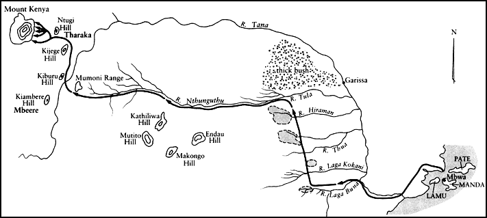
Map 3
Meru migration route: 1700–1730
Initially, the Ngaa appear to have been drawn toward the shelter of Mount Kenya's forest. Tradition states that they first settled at a point along the lower forest fringes, where they encountered the already resident Cuka. After a severe clash, the Cuka drove the migrants off; the Ngaa fled downhill into the plain, then north into the area now known as Tharaka.
Perhaps to their own amazement, they were received there in peace and dwelt for a considerable length of time in that section of the plain which then belonged to the Mbugi/Diacho clans. Traditions from both societies confirm they lived in harmony and that considerable intermarriage occurred. Perhaps for this reason the earlier unity of the Ngaa gradually dissolved, and they entered an era recalled in both Meru and Tharaka tradition as "the time of dividing" (Meru: kagairo ; Tharaka; igaironi ).
During this period, perhaps in the late 1730s, the original Ngaa nucleus separated into two segments, each of which took on an identity of its own. One was known as Mukunga (or Muku Ngaa: people of Ngaa). The other became Murutu, a name that may have been taken because of intermarriage with the Chagala/Murutu section of pre-Tharaka.
Initially, these two sections maintained their traditional (northwestern) direction of march. At a point that tradition places near today's Ntugi Hill, however, they fragmented once more. The Murutu appear to have divided into three smaller sections. One, retaining the name, remained on the plain to become part of the contemporary Tharaka. A second group moved westward toward Mount Kenya, eventually reaching the mountain base at the modern region of Mwimbi. The third segment pressed north into a then heavily wooded plain, known today as Tigania. In the years to come all three groups would remember their period of common identity ("Mwimbi, Tigania, and Murutu were once one") by creating rituals of pretended kinship that would eventually form the basis of military alliances between all three.
The second major segment of the original Ngaa fragmented in similar fashion, dividing into four and possibly five smaller sections. One moved northward toward the heavily forested mountains of the Nyambeni range, which stretches northeast from the base of Mount Kenya. Three others moved west, into the foothills that make up the lowest portions of modern Igoji, Abogeta (South Imenti), and Abothoguchi (North Imenti). The final group drifted south, eventually entering that part of the Mwimbi region that lies adjacent to modern Muthambi—an
area they eventually seized from the Cuka in the 1880s. These groups too would commemorate their period of common identity ("Igoji, Igembe, Imenti, and Muthambi had one father") by establishing rituals of kinship that would evolve into military alliances, bonds that would set them against the clans of Mwimbi and Tigania and form the basis for future internecine war.
Tradition suggests that each migrant group may have adopted the Tharaka name for the mountain regions into which they climbed, a suggestion also advocated by H. E. Lambert. Lambert, using linguistic data, believes the migrants needed only to apply the prefix amu - (people of) or iga - (place of) to the Tharaka root word for each region. Thereafter, the original Ngaa prefix may have been incorporated into the compound word, eventually losing its separate meaning.[18]
Traditions from at least two regions support this theory to the south, the earlier "Amu-imbi," a name still recalled by informants, became "Mwimbi" (or Muimbi) rather than "Aimbi." If one applies the principle elsewhere, "Amu-thambi" becomes "Muthambi," and "Amu-iru" ("black" clans—those who fled Mbwaa at night) becomes "Mwiru," a form by which sections of contemporary Meru were known during the 1890s and which they still use to refer to themselves.
Similarly, tradition declares that the prefix iga - clearly applied to Igembe, whose people were known simply as the Mbe until 1900. When applied elsewhere, the concept suggests that those migrant groups entering Igoji (iga-oji ), Imenti (iga-mente ), and Tigania (iga-nia ) may have followed similar patterns, each adopting the previous Tharaka name as their own. Certainly, tradition emerging from this point in time (1740s) up to the twentieth century says nothing more of the Ngaa; the name disappears entirely from the flow of oral history, which is recounted only from the perspective of these smaller social units (i.e., the lgoji, Imenti, and so forth), until the European conquest.
A question still remains, however, as to the reason for this fragmentation. Why would a band of migrants, sharing language, culture, and a common past trek thirty years through what must have seemed an arid wilderness only to break apart upon reaching more promising land? Neither the Meru nor Tharaka chronicles provide reasons for such fragmentation, other than to confirm it was not caused by war.
The answer, therefore, may be simply that various components of the original migrant group were faced with the lure of a wholly new type of topography. At that time the rugged lower slope of northeastern Mount Kenya and the neighboring Nyambeni Mountains were thickly for-
ested. To the migrants they must have promised cool grazing, virgin cropland, inexhaustible water, and refuge against enemy attack. The choice was whether to seek the more favorable altitude or remain on the Tharaka Plain.
The slopes of this section of Mount Kenya, however, are also divided into steep, precipitous ridges, separated by swift rivers that are frequently in flood. Meru clan traditions invariably declare that their ancestors settled their respective sections by moving up along these rivers.[19] This seems consistent with their behavior throughout the migration and helps to answer the larger question of how a coastal island community settled finally on a forested mountainside. Because every portion of their earlier journey seems to have followed some form of swamp or river system, it is not difficult to imagine fragmentation occurring when they were faced with many smaller water systems emerging from a single mountain.
In their efforts to exploit this new environment, therefore, numbers of the migrants may simply have drifted out of contact with one another, becoming separated by the forest and the rugged ridges that they climbed, until gradually their common identity and even their common name had disappeared. Politically fragmented and demographically few, each band began to climb Kirima Kia Maara (now Kirimaara), the shining mountain, today's Mount Kenya.[20]