Chapter 4—
Calderas and Their Geothermal Systems
Large eruptions of pumice and ash can cause the collapse of rock that overlies shallow magma chambers, thus forming craters called calderas (from the Spanish for "cauldron" or "kettle"). Calderas range from a few kilometers to 60 km in diameter and are associated with eruptions of several cubic kilometers to several thousand cubic kilometers of pyroclastic material. Caldera-forming eruptions are infrequent—occurring perhaps only once every few thousand years.
The very magnitude of the largest calderas has, on occasion, prevented geologists from recognizing them in the field. However, as early as 1885, Verbeek proposed that the crater left after the 1883 eruption of Krakatau was formed by a collapse accompanying the eruption of large volumes of ash and pumice. Other studies, particularly of older, eroded volcanic fields in the British Isles, led to the conclusion that subsidence followed this type of volcanic eruption. The significant study that brought the collapse mechanism for crater formation into mainstream geology was a review of known calderas by Williams (1941). Williams' review was published concurrently with his study of the Crater Lake Caldera in Oregon (Williams, 1942), in which he linked caldera collapse to the eruption of Mt. Mazama ~7,000 yr ago. In other, related work, Ross and Smith (1961) reviewed the available data for tuff deposits found around calderas and Smith and Bailey (1968) developed a model for caldera formation and structural caldera resurgence, concentrating on the Valles caldera of New Mexico (Fig. 4.1). Since that time, the research on calderas and their deposits has accelerated; today, much more is known about eruption phenomena, caldera-collapse processes, magma-chamber evolution, and the evolution and history of caldera hydrothermal
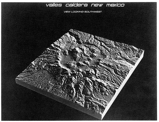
Fig. 4.1
Block diagram of the Valles/Toledo caldera complex in New Mexico. The topographic
depression is 22 km in diameter. The actual collapse crater is 15 km in diameter; its location was
inferred from locations of rhyolite domes erupted after the caldera collapse. The bulbous mountain
near the caldera center is a structural resurgent dome caused by
the buoyant rise of magma after the caldera collapsed.
(Block diagram by Harlan Foote, Pacific Northwest Laboratories).
systems. A particularly useful collection of papers on calderas was published as a special volume of the Journal of Geophysical Research edited by Lipman et al . (1984). In this book chapter, we will briefly review the processes leading to caldera formation, eruption and collapse, and postcaldera activity, including the development of hydrothermal systems.
Intrusion
Silicic calderas are associated with crustal magma bodies, the tops of which are at inferred depths of 4 to 10 km. Geothermal resource evaluation requires information about the depth, shape, size, and age of such bodies that supply heat to geothermal systems. Although most thermal models of these magma bodies are based on cube-, slab-, and cylinder shapes, geological and geophysical evidence indicates that silicic plutons have inverted, tear-drop shapes and are no more than 10 km thick (Bott and Smithson, 1967; Cobbing and Pitcher, 1972). Smith and Shaw (1975) proposed that the pluton diameter is equal to or somewhat greater than that of the caldera ring faults.
Excellent examples of plutonic-volcanic associations, particularly plutonic complexes believed to have underlain calderas, are visible within the Peruvian batholith (Cobbing and Pitcher, 1972; Myers, 1975); these are steep-sided plutons with domical roofs that have intruded into caldera fill and sub-caldera rocks. Collectively, the many various types of plutons emplaced over millions of years make up what is termed a batholith . Thermal metamorphic effects suggest that plutons of the Peruvian batholith were once within 3 km of the surface (Meyers, 1975).
The Uyaijah ring structure of Saudi Arabia consists of a 15- by 20-km oval ring dike, 2 km thick, which surrounds a granite stock and is believed to have underlain a caldera (Dodge, 1979). The pluton appears to have an inverted tear-drop shape similar to those of the Peruvian batholith (Fig. 4.2).
Of the 40 high-level plutons that make up the granitic ring-dike complexes of the Jos Plateau of northern Nigeria, many are believed to have underlain calderas (Jacobson et al ., 1958). Figure 4.3 provides a comparison between this complex and those of the Valles/Toledo complex of New Mexico and the Lake City complex in Colorado. Various periods of pre- and post-collapse intrusion and volcanism that are characteristic of caldera clusters created the Nigerian plutonic complexes. The polygonal shapes of many of these plutons and associated dike systems were controlled by fault and fracture patterns that existed before the plutons were emplaced and before caldera-forming eruptions occurred. Associated with these plutons are glassy, brecciated rhyolitic dikes and uniform rhyolitic rocks that have been interpreted as caldera-fill deposits.
There is increasing evidence, based on geological research and thermal models, that most—or even all—large silicic plutons are underlain, surrounded by, or mixed with basaltic intrusions. Without the heat supplied by hotter mafic magmas, the large, silicic magma bodies cannot rise as crustal diapirs (Lachenbruch et al ., 1976;
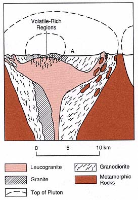
Fig. 4.2
Schematic cross-section of the composite,
subcaldera pluton that makes up the Uyaijah
ring structure in Saudi Arabia. "A" marks the
present-day ground surface. Dodge (1979)
postulated that this pluton once lay
beneath a caldera complex.
(Adapted from Dodge, 1979)
Eichelberger and Gooley, 1977; Hildreth, 1981). The viscosity of a cooling magma body can increase to the point where it stops rising and never reaches the shallow crust to erupt. Many caldera complexes are located in volcanic fields that exhibit bimodal volcanism: the more silicic rocks are in the center of the field overlying a silicic magma body and the basaltic lava fields are located around the flanks. Basaltic magmas trapped beneath a silicic pluton cannot pass through it because they are more dense and thus buoyant rise is suppressed; however, these magmas can rise to the surface along fractures in the brittle crust adjacent to a silicic pluton.
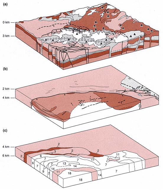
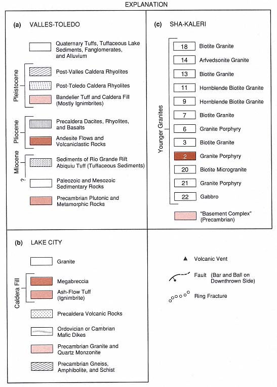
Fig. 4.3
These composite block diagrams schematically represent different levels below a caldera complex and
illustrate an igneous system within the upper 6 km of crust. These examples are from three different areas
where rocks are exposed or have been sampled by drilling. (a) Geologic map and cross-sections of the
north-northeast quarter of the Valles and Toledo calderas of the Jemez Mountains in New Mexico.
The geology is based on data and maps from Smith et al . (1970), Dondanville (1971;1978),
Slodowski (1977) and Hartz (1976).
(Adapted from Heiken and Goff, 1983.)
(b) The Lake City caldera in Colorado is similar to the Valles/Toledo calderas in size
and composition, and its interior has been well exposed by erosion. The upper
surface of the diagram is at a level that was originally ~2 km below the ground
surface present at the time of eruption, 22.5 million years ago.
Tuffs and interbedded breccias of the caldera fill are intruded by a silicic pluton.
(Adapted from Lipman, 1976.)
(c) This diagram is based upon maps of the Sha-Kaleri intrusive complex in northern Nigeria
by Jacobson et al . (1958). Interpreted as a cluster of plutons that were emplaced below a large caldera,
it may be analogous to the plutonic complex that underlies the Jemez volcanic field. The diagram
illustrates the potential complexity of a composite plutonic body below a caldera.
Mount Mazama Volcano, which erupted ~50 km3 of magma 7000 years ago, is a well-documented example of the basalt/rhyolite association required for the rise of a large silicic magma body. Rhyodacitic pumice was erupted first, followed by a mixture of the rhyodacite, crystal-rich andesitic pumice, and mafic-cumulate scoria (Bacon, 1989). When the caldera collapsed during the eruption, Crater Lake caldera was formed. Preeruptive magma temperatures ranged from 880°C for the rhyodacite and early andesite phase to >940°C for the late-erupted scoria phase. Analysis of H2 O in melt inclusions suggests that depth to the magma chamber was 6 km. Using 87 Sr/86 Sr ratios for the eruption products as evidence, Bacon suggested that the magma chamber grew during injection of multiple parent liquids, forming a hot lens between plagioclase-rich cumulates and the overlying rhyodacitic magma. A buoyant, differentiated melt mixed into the overlying rhyodacite and crystal mush to form a new cumulate layer. Basaltic fluids then penetrated the base of the cumulate pile. Had the caldera-forming eruption not occurred, crystallization would have formed a granodiorite pluton overlying a dioritic to gabbroic cumulate.
Large-volume, caldera-forming eruptions usually occur late in the history of a volcanic field. Most of these eruptions have been preceded by smaller scale eruptions of mafic to intermediate magmas—sometimes over periods of millions of years, as was described by Lipman (1984) and depicted in Fig. 4.4. This type of volcanic field may consist of dozens of vents, including those of composite cones, scoria cones, lava domes, and small calderas. Rarely, if ever, has a large, single composite cone collapsed to form a caldera. There are many examples of a complex volcanic field being developed before a caldera is formed, including Crater Lake in Oregon, where Howel Williams developed his caldera models (Bacon, 1983; Druitt and Bacon, 1986), Thira (Santorini) in Greece (Fouqué, 1879; Heiken and McCoy, 1984), and the Valles caldera in New Mexico (Smith et al ., 1970; Gardner et al ., 1986).
Eruption Processes That Lead to Caldera Collapse
Caldera-forming eruptions begin when pressure within the volatile-rich cap of the magma chamber can no longer be contained by the overlying rock. Conduits to the surface may follow faults and fracture systems [see (a) of Fig. 4.5]. In some instances, the main eruption is preceded by phreatic (steam) explosions and by relatively mild explosive eruptions and lava flows. Bacon (1983) described such precursor activity at Crater Lake, Oregon, where a still partly molten lava flow was erupted before the collapse and flowed back into the new crater. Phreatic and phreatomagmatic activity (explained in Chapter 2) may also have been precursors to the main Minoan eruption at Thira, Greece (Heiken and McCoy, 1984), and at Krakatau in Indonesia (Simkin and Fiske, 1983), where there were small ash eruptions for days before the main eruption.
From observation and inferences from field relations, it appears that caldera-forming eruptions last only a few hours or days (for example, at Krakatau in 1883; Simkin and Fiske, 1983), if one does not include smaller ash eruptions or the lava flows that may follow caldera formation. The first and most explosive phase begins with an eruption of volatile-rich magma as pumice and ash, which forms a high eruption column. This phase generally produces fallout or a Plinian pumice-fall deposit (see definitions in Appendix G). Massive or graded pumice beds (with coarser fragments at the base of the bed) drape the countryside. This first phase may erupt from a single conduit or closely spaced conduits, as depicted in part (c) of Fig. 4.5. Plinian eruption phases from a single conduit have been widely documented in isopach and isopleth maps as well as maps of lithic clast distributions (for instance, Hildreth and Mahood, 1986; Heiken and McCoy, 1984; Self et al ., 1986). Volumes of pumice fallout deposits depend upon the overall size of the magma body,
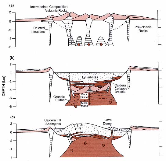
Fig. 4.4
The evolution of a large silicic caldera. (a) Volcanism before caldera collapse. Clusters of composite
cones develop over isolated, small plutons that eventually coalesce to form a large silicic magma
body or heat the shallow crust sufficiently to allow the buoyant rise of a large pluton. The site of
subsequent caldera collapse is marked by dotted lines. (b) Caldera structure immediately after
the eruption of ignimbrites and concurrent caldera collapse. Calderas contain thick tuff deposits
that are interbedded with megabreccias. Dashed lines approximate the compositional zones
developed within the pluton. (c) Caldera resurgence. Welded tuffs and other caldera deposits are
uplifted as a structural dome over the magma body. Postcaldera collapse volcanism and
sedimentation occur mostly along an annulus between the resurgent dome and caldera walls.
Hydrothermal systems develop within the caldera deposits and floor rocks, as well as along
extensional faults that cross the resurgent dome.
(Adapted from Lipman, 1984.)
but when ~20% of the total eruptive volume has been ejected, caldera collapse may be initiated (Smith, 1979). Druitt and Sparks (1984) proposed that when a small fraction of material has been erupted, the pressure within the magma chamber decreases rapidly to values less than that of the lithostatic pressure and the chamber roof begins to collapse catastrophically [parts (c) and (d) of Fig. 4.5].
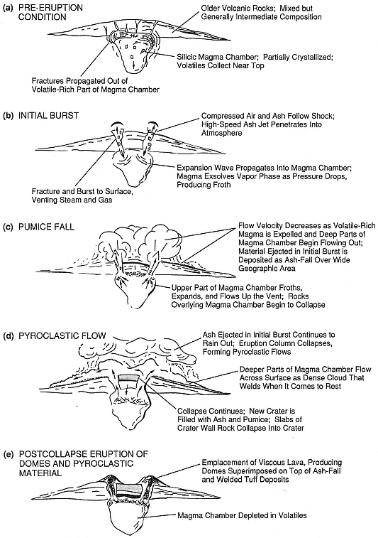
Fig. 4.5
Inferred stages of eruption and collapse of a large silicic magma chamber and caldera.
(After a drawing by T. McGetchin, 1976)
The rocks overlying a magma chamber roof collapse into the partly evacuated chamber and form new fracture systems, which approximately outline the magma body. Complete or piecemeal subsidence may occur along the fractures, creating ring faults with a concentric pattern. During this stage, eruptions may occur continuously or intermittently along the newly formed ring faults [(Fig. 4.5 (d)]. As blocks that make up the caldera roof begin to collapse, the ring faults may open widely and allow large quantities of pyroclastic material to erupt; these same roof blocks can rotate back into place, closing off the fractures and opening other fracture vents. Roof subsidence not only allows eruptions to occur over long sections of ring faults, but also may displace magma and drive it to the surface (Druitt and Sparks, 1984). It is usually during this stage of the eruption that the hotter but more volatile-poor ash and pumice are deposited around the caldera as pyroclastic flow deposits or ignimbrites, as shown in Fig. 4.6 (Self et al ., 1986; Hildreth and Mahood, 1986). Ignimbrite deposits, located around the periphery of a caldera, form plateaus that slope away from the source. These tuff deposits are usually thickest within and along the edges of the caldera, thinnest at the distal plateau margins, and generally absent on steep slopes. Details of facies changes within ignimbrites are discussed in Chapter 2 and by Fisher and Schmincke (1984).
Caldera collapse occurs during and not after an eruption—an important concept to keep in mind when examining caldera structure and seeking caldera-hosted geothermal resources. Perhaps as much as 50% of the erupted pyroclastic material collects within the caldera crater, especially in the largest calderas where many of the pyroclastic flows never surmount the crater wall; these tuff deposits are usually 1 to 3 km thick and can be as much as 5 km thick (Lipman, 1984, and personal communication). Because their depositional temperatures are 500 to 600°C, the rapidly deposited pumice and ash may be compacted, welded, and altered by remnant gases and heated groundwater. For every ignimbrite exposed around caldera margins, there is a texturally different (welded, devitrified, and perhaps hydrothermally altered)—but correlative—thick tuff sequence within the caldera. Table 4.1 presents the lithologic sequences commonly found in such caldera-fill deposits and correlative outflow deposits.
Figure 4.7 provides an example of intra-caldera ignimbrite deposits interbedded with breccias that formed when unstable caldera walls avalanched into the collapsing Lake City caldera (Lipman, 1975; 1984). Mesobreccias consist of concentrations of small lithic clasts interlayered with the middle and upper parts of the caldera-filling tuffs. Megabreccias are made up of clasts that are generally larger than an individual outcrop; they actually are intact slump blocks located near the bottom of the caldera filling (Lipman, 1975). The slumping that forms megabreccias may leave scalloped topographic caldera walls that extend outward from the ring faults for hundreds of meters or several kilometers. Megabreccia blocks occur at different stratigraphic horizons in a caldera fill, which suggests a piecemeal failure of steep caldera walls during collapse (Meyer, 1989). The slumping of large megabreccia blocks may make it difficult to map the actual caldera wall, as defined by ring faults; in many cases, the topographic caldera wall is located well outside the actual structural caldera. The lenslike deposits of caldera-collapse breccia act as heat sinks within the caldera-filling tuffs: they rapidly cool the adjacent hot ash deposits and locally limit the compaction and welding of glassy pyroclasts.
Near the caldera rim, outflow ignimbrites contain concentrations of lithic clasts called lag breccias (Druitt and Sparks, 1982; Druitt and Bacon, 1986). These lithic clast concentrations (shown in Fig. 4.8) may indicate episodes of caldera-wall collapse or vent widening during explosive eruptions. The ability to recognize caldera-collapse breccias and associated nonwelded tuffs within
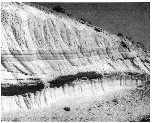
Fig. 4.6
Photograph of a pumice fall and ignimbrite deposit in the Bishop Tuff, Long Valley Caldera,
California. Interstratified surge and pumice fallout deposits are
overlain by a massive ignimbrite.
drillholes and in surface outcrops is important for identifying hydrothermal reservoirs within the calderas because these deposits may be more permeable than the densely welded tuffs that enclose them.
Volcanism, Structural Deformation, and Sedimentation Following Caldera Collapse
Immediately after caldera-forming eruptions, the craters become closed sedimentary basins. Crater lakes may form and the process of fluvial and lacustrine sedimentation begins. If it is adjacent to the sea, the crater is flooded and may eventually be filled with marine sediments. If a caldera wall is breached, the lake drains and a new drainage system is established. Well-bedded lacustrine mudstones and siltstones may eventually fill smaller calderas, but structural resurgence within larger calderas will limit the crater lakes to an annulus between the central structural dome and the caldera wall, like that of the Creede caldera of Colorado, depicted in Fig. 4.9 (Smith and Bailey, 1968; Heiken and Krier, 1987).
Interbedded with the laminated lacustrine mudstones are reversely graded breccias (turbidites from caldera walls), coarse sandstones (fluviatile rocks and small deltas), volcanic ash beds (both ash-fall and pyroclastic-flow deposits), and lavas from postcaldera eruptions.
Mapping and age-dating of caldera-lake sedimentary rocks can provide information
| ||||||||||||||||||
to be used in determining the time and rate of structural resurgence. By employing lake beds as markers, it is possible to measure the amount of deformation during resurgence; for example, Mahood (1980) measured the degree of resurgence of La Primavera caldera in Jalisco, Mexico, by mapping the elevation of caldera lake sedimentary rocks and interbedded tuffs (Fig. 4.10).
The buoyant rise of magma or injection of new magma following a caldera's collapse can be inferred from structural deformation of the caldera floor and postcollapse volcanic activity. Structural resurgence is common in calderas with diameters of 10 km or greater (Smith and Bailey, 1968). Deformation may result in a simple symmetrical dome within the caldera fill, and radial dips within these deposits may
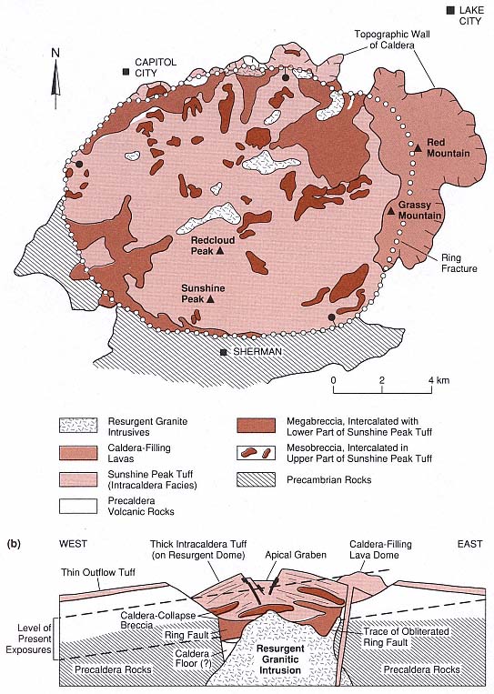
Fig. 4.7
Geologic map and schematic cross-section of the Lake City Caldera of Colorado, showing the
distribution of meso-and megabreccias that are intercalated within thick caldera-fill tuff deposits.
(Adapted from Lipman, 1976.)
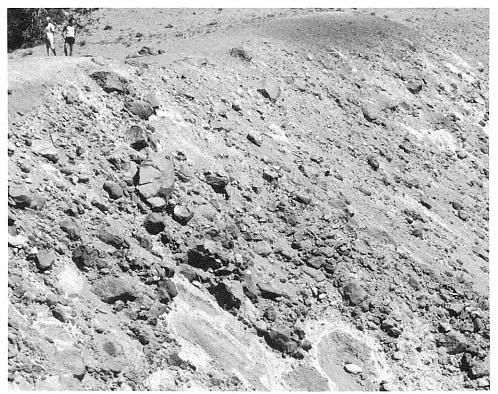
Fig. 4.8
The concentration of boulders and cobbles in the cliff shown here are lava lithic clasts that
make up a lag breccia interbedded with ignimbrites surrounding the Crater Lake caldera in
Oregon. These breccias may have been formed by gravity segregation of the dense lithic
clasts near the crater rim during the caldera-forming eruption of rhyolitic ash. Lag breccias
may be used as markers that indicate periods of caldera collapse during the eruption.
range from a few tens of degrees to 45°, as is shown in Fig. 4.7 (b). However, many resurgent domes are more complex and reflect the precaldera structural control of the caldera's shape. For example, within an asymmetric "trapdoor" caldera (hinged on one side with substantial collapse on the other side), resurgence that takes place adjacent to the bounding faults forms an oval dome parallel to those faults (Nielson and Hulen, 1984). The dome heights relative to the original crater floor range from a few hundred meters to more than a kilometer. Summits of most resurgent domes are broken by "keystone" grabens. The fault orientations of these grabens may be influenced by older structures; for example, they may follow the trend of precaldera faults in rocks underlying the volcanic field, as Nielson and Hulen (1984) noted for the Valles caldera of New Mexico (Fig. 4.11).
The probable resurgent intrusions identified in the deeply eroded calderas of Questa, New Mexico; Turkey Creek, Arizona; and Mt. Aetna, Colorado, rise above the basement rocks and intrude intracaldera tuff deposits (Hon and Fridrich, 1989). Areas of maximum uplift within these calderas are directly above the resurgent plutons. The interface between the fractured caldera floor and the block of densely welded intracaldera tuff allows rising magma to spread out. Hon and Fridrich (1989) inferred
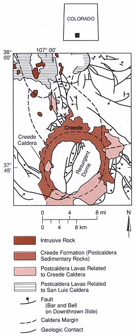
Fig. 4.9
Simplified geologic map of the Creede caldera in
Colorado, showing distribution of the Creede
Formation—tuffaceous sedimentary rocks that
partly filled the annulus (moat) between the
resurgent dome and caldera walls. The same
zone is partly filled by lava domes and flows
erupted after caldera collapse. The Creede
Formation consists of several facies from the
fanglomerate breccias of the caldera walls and
slopes of the resurgent dome, intermediate fluvial
sandstones and gravels, and lacustrine siltstones
of the annulus between caldera walls
and a resurgent dome.
(Adapted from Steven and Eaton, 1975.)
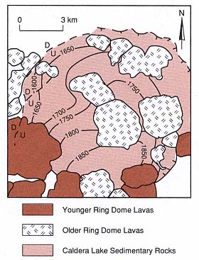
Fig. 4.10
Structural contour map of tuff deposits (known
as the "gaint pumice horizon") interbedded with
caldera lake sediments of the La Primavera
caldera in Jalisco, Mexico; elevation in meters
(from Mahood, 1980). Resurgence was
asymmetrical, with maximum uplift in the
southeastern corner of the caldera.
that initially the resurgent plutons had a laccolithic form but that this form was eventually modified when stoping during subsequent phases produced more or less cylindrical intrusions similar to the central plutons of ring complexes. Those authors also proposed that the resurgence here was more likely related to continued magmatic input (10-2 to 10-3 km3 /year rather than to renewed magmatic pressure caused by vesiculation, as was suggested by Marsh (1984).
Structural resurgence can be a rapid process. At Long Valley caldera of California, Rabaul caldera in Papua-New Guinea, and the Phlegrean Fields of Italy, active deformation of centimeters or meters have occurred over only decades (Newhall and Dzurisin, 1988).
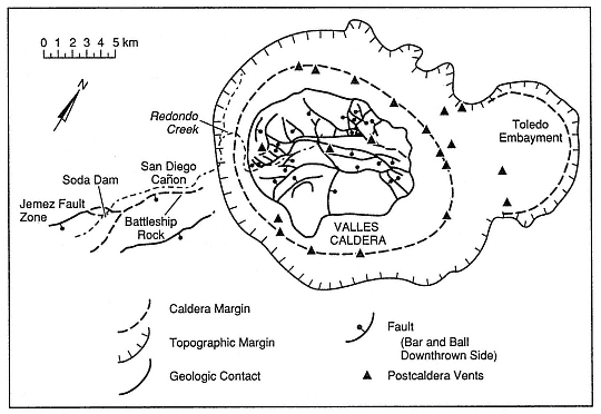
Fig. 4.11
Map of the Valles caldera in New Mexico, showing faults that cross
the caldera complex and faults within the 1-km-high resurgent dome.
(Adapted from Nielson and Hulen, 1984.)
Resurgence can also be an intermittent process in which uplift is followed by alternating subsidence and uplift. Bailey et al . (1976) stated that inferred times for resurgence of older calderas range from <10,000 to ~100,000 years. Although the time required for resurgence obviously varies greatly, for the best-documented modern example, at the largely submarine Iwo-Jima caldera of Japan, the average rate of uplift has been 15 to 20 cm/year since the caldera floor rose above sea level 500 to 700 years ago (Kaizuka et al ., 1989).
Such structural resurgence has a significant effect on the thermal history of a caldera. Thermal gradients within resurgent calderas are higher than in calderas with no resurgence (Zyvoloski, 1987). In addition, hydrothermal systems can develop along faults associated with the keystone grabens that are typical of resurgent domes because fracture permeability is necessary for the meteoric water circulation within densely welded caldera-fill tuffs.
After caldera collapse, small, less explosive eruptions may begin along ring faults or along faults that bisect the caldera. The lavas and pyroclastic rocks erupted are less volatile-rich than the pyroclastic materials of caldera-forming eruptions (Hildreth et al ., 1984). Within most calderas, dacitic or rhyodacitic dome lavas are erupted along the ring faults over periods ranging from a few decades to >1 myr after the initial caldera-forming eruption (Fig. 4.12). Heiken and Wohletz (1987) reported that a variety of pyroclastic rocks are associated with these domes, including hyaloclastic deposits of tuff rings, ash fall beds, and small pyroclastic flow deposits. Postcaldera volcanic activity ranges from eruptions of a few isolated vents to eruptions of postcaldera domes,
cones, and flows that can fill the caldera. Calderas located along volcanic arcs at the plate margins may be partly buried by composite cones that consist of lavas and pyroclastic rocks of intermediate composition; such cones are well-documented throughout Central and South America, in the volcanic fields of Kamchatka in the Kurile islands, and along the Japanese island chain. The magmas supplying postcaldera volcanoes are far less voluminous than the caldera magma body, but they form shallow magma bodies and cause magma-induced fractures that are needed for hydrothermal systems.
Caldera Structure and Shape
The "ideal" caldera, formed during an eruption through homogeneous, unstressed rock units, is circular in plan view and plug or broadly funnel shaped in cross section (Anderson, 1936). However, the upper crust of the Earth is neither physically homogeneous nor unstressed. Caldera structure and shape are affected by prior structural trends, the depth to which the magma body has intruded, the physiographic expression of the precaldera volcanic field, and the energy of the eruption itself. Caldera complexes formed by multiple, overlapping calderas are common.
Figure 4.13 provides a cross-section view for a variety of caldera shapes. The most common caldera type is that of a subsided, semicylindrical block that is marked at the surface by concentric normal faults. In cross-section—shown in (a)—the subsiding block drops along concentric faults piece-meal, resulting in a structure that looks like the step-like seats of a stadium. In most of these calderas, the ring fault marks the actual caldera wall, but the en echelon faults of slump blocks extend out to the topographic rim. Rarely, if ever, are these calderas circular; most are oval or polygonal. The Aira and Ishizuchi calderas of Japan (Aramaki, 1984; Yoshida, 1984) and the Minoan caldera of Greece (Heiken and McCoy, 1984) are polygonal; the caldera walls follow trends of regional faults and fractures present long before those eruptions occurred (Fig. 4.14). Long Valley caldera in California, an east-west-trending oval, is almost polygonal; it is located at the intersection of major north-northwest-trending fault zones that mark the eastern boundary of the Sierra Nevada and an east-west offset in those fault zones. The giant Cerro Galan caldera of Argentina, a north-south-trending elongate oval, is adjacent and parallel to a north-south-trending rift in the Andean altiplano (Francis et al ., 1978). Most calderas exposed by either erosion or drilling fit this general model of a down-dropped block. However, there are variations on the geometry of the down-dropped block or "plug," including those with vertical faults and reverse faults that dip outward rather than inward, as depicted in Fig. 4.13 (c) and (d).
Trapdoor calderas, in plan view, are similar to the plug-like calderas and show the same variation in shape. In cross section, however, they are very different: collapse is asymmetric and one side is much lower than the other [Figs. 4.13(b) and 4.15]. Faults may mark both sides, but one side is more of a flexure or "hinge" than a fault—thus the term "trapdoor."
Nielson and Hulen (1984) and Heiken et al . (1986) interpreted the Valles caldera of New Mexico as a trapdoor caldera. It overlaps the margin of the Rio Grande Rift, where depth to the Precambrian basement is 700 m below the western caldera margin and perhaps as much as 3 km below the eastern caldera margin. In this case, the asymmetric collapse appears to be related to the distribution of underlying rocks and rift margin faults; the competent basement rocks at shallow depths act as the hinge. Many of the intermediate-size calderas in Japan (~10-km diameter), interpreted as funnel shaped, were formed not by the sinking of a cylindrical block but by the piecemeal collapse of roof rock, as is
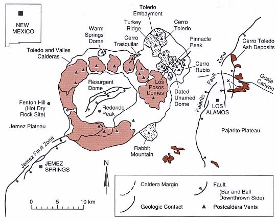
Fig. 4.12
Sketch map of the Valles/Toledo caldera complex, showing postcaldera rhyolite domes.
The stippled pattern represents Toledo-age domes (1.0 to 1.4 myr); the light brown shading indicates
Valles domes that range in age from slightly less than 1 million years to ~100,000 years.
Triangles mark the vents of intracaldera volcanoes.
illustrated in Fig. 4.13(e). An example of this type of caldera is the Shishimuta caldera of the Hohi volcanic zone in Kyushu, Japan (Kamata, 1989). This structure formed during the eruption of the Yabakei pyroclastic flow 1.0 million years ago, during which 110 km3 of tephra were erupted. The Shishimuta caldera is 8 km wide and >3 km deep. Much of the caldera fill is an andesitic breccia made up of fragments and slabs of precaldera rocks, which is overlain by 500-m-thick lacustrine deposits. There is no evidence of structural resurgence at the Shishimuta caldera. Kamata (1989) proposed that the caldera fill is primarily composed of explosively disrupted roof rock and that there is little collapse.
Small calderas, often associated with cones or tuff rings, may form when vent walls collapse into a vent that has widened during an explosive eruption [Fig. 4.13(e)]. Vent wall collapse is common in diatremes, which are the vents for small, explosive eruptions (usually phreatomagmatic) of basaltic, alkalic, or kimberlitic magmas. Such craters, however, are formed by explosive activity and the disruption of vent walls rather than by collapse over shallow magma bodies and therefore rarely have geothermal potential. By strict definition, they should not be termed calderas.
Walker (1984) has proposed that the simplest and most poorly developed
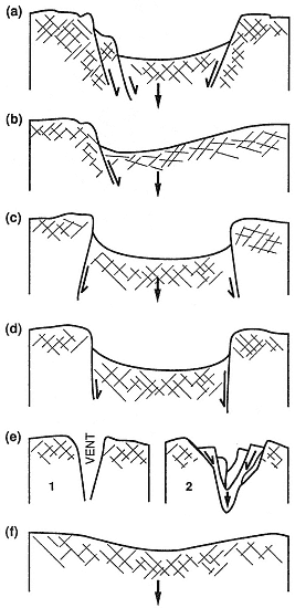
Fig. 4.13
Sketches of possible caldera shapes in cross-
section; both observed and inferred shapes
are presented here. (a) Normally faulted down-
dropped block, observed in most continental
calderas. (b) Trapdoor caldera, in which most of
the collapse occurs along one margin and the
other margin acts as a "hinge." (c) Collapse
along outward-dipping faults, as seen in some
eroded calderas in Great Britain (Anderson, 1937).
(d) Caldera subsidence along piston-like
vertical faults (inferred). (e) Collapse into a small
vent eroded during explosive eruptions, as
exhibited by some maar volcanoes and
kimberlitic diatremes; many volcanologists
would not call these calderas. (f) Simple
downsag, or flexure, without faulting; this
caldera type was proposed by Walker (1984).
(Adapted from Walker, 1984.)
calderas are "downsagged" and have little or no development of ring faults [Fig. 4.13(f)]. Walker's chief example is Lake Taupo in New Zealand, where an enormous eruption, 1800 yr BP, formed a broad, shallow depression 30 km in diameter and 300 to 500m deep. This interpretation must be considered inconclusive because the only evidence is a saucer-shaped surface expression; little is known about the extent or thickness of any possible caldera fill within the Taupo caldera.
Many of the Earth's large calderas are not single features, but caldera complexes, which are composed of adjacent or overlapping craters formed during multiple eruptions. For instance, the Yellowstone region in the United States comprises three overlapping calderas that were formed during three major eruptions that occurred at intervals of ~600,000 years. Calderas of the San Juan Mountains in Colorado, shown in Fig. 4.16, often form clusters with considerable overlap. In many cases, caldera complexes have been mapped earlier as single calderas. One can determine if a crater is composed of one or several calderas by identifying the number and ages of ignimbrites surrounding the crater. If there is only one ignimbrite, it was most likely erupted during formation of a single caldera. If there are multiple ignimbrites with considerable time gaps between eruptions, there is a very high probability of multiple, overlapping calderas. For many years, geologists believed that Toba caldera in Sumatra was formed during one eruption. However, recent work on Toba demonstrated that it is a composite caldera that formed during three major eruptions of silicic ash (Knight et al ., 1986; Chesner, 1988).
Some caldera complexes have formed not as overlapping craters, but through multiple collapses of the same crater. The Valles and Toledo calderas of New Mexico were formed during two major eruptions 400,000 years apart; the eruptions were of similar
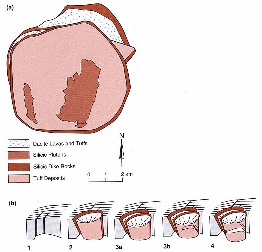
Fig. 4.14
(a) Structural map of the Ishizuchi caldera in Japan. The polygonal shape created during
caldera collapse follows the general structural grain of precaldera rocks. Faults and
fractures present before the caldera-forming eruption often control the caldera shape.
(b) Block diagrams showing stages of development of the Ishizuchi caldera.
(Adapted from Yoshida, 1984.)
magnitude and each deposited pumice falls and pyroclastic flows. These eruptions may have buried several older but smaller calderas. Drilling within the Valles/Toledo caldera complex revealed two main sequences of caldera tuff deposits and several smaller deposits—a pattern that usually correlates with tuff sequences surrounding the calderas. The younger caldera (the Valles) appears to have collapsed along the same faults as the older caldera, so that one lies on top of the other.
Geothermal Systems in Calderas
Large, young calderas and associated volcanic rocks are indicators of potentially immense geothermal resources. Smith and Shaw (1975) estimated that for every cubic kilometer of material erupted, between 3 and 9 km3 of partly molten rock resides below the volcanic field but within the upper 10 km of crust. The geothermal resource beneath a caldera exists as long as eruptive activity continues; in addition, if large silicic crustal magma bodies are
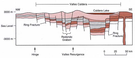
Fig. 4.15
Schematic cross section of the Valles/Toledo calderas of New Mexico. The caldera complex, which
appears to have a trapdoor shape, has a "hinge" on the northwest side where it overlies Paleozoic
sedimentary rocks and Precambrian metamorphic and igneous basement. Most collapse has
occurred along the eastern caldera margin where the caldera overlies the Rio Grande Rift
and a thick sequence of poorly consolidated rift sedimentary rocks.
formed, the resource has a lifetime of several million years after the final volcanic activity (Kolstad and McGetchin, 1978). As will be seen in the case histories discussed here, the magnitude of the accessible hydrothermal system depends entirely on the extent of permeable zones below the caldera or within the caldera deposits. In most calderas containing thick, densely welded tuff deposits, the hydrothermal systems are limited to caldera ring fractures and caldera-crossing faults, which form zones of fracture permeability. Evidence of hydrothermal activity is often seen in the acid-sulfate alteration that occurs at the surface. Acid fluids are formed when H2 S and CO2 escape from the underlying hot water reservoir and are oxidized at shallow depths. Water within these reservoirs is usually heated groundwater from recharge areas within the caldera.
Thermal models of calderas indicate that much of the elevated heat flow is conductive and that convective heat transfer is mostly limited to fault zones. Magma bodies below the larger calderas (>10-km diameter) cool slowly and may be heat sources for up to 2 million years. An example of such a system is the 15-km-diameter Valles caldera of New Mexico, where the most recent major eruption took place 1 million years ago and the most recent intracaldera eruption was 150,000 years ago. Along the keystone graben of the resurgent dome, the temperature is still 341°C at a depth of 3 km (ambient temperatures at a depth of 3 km in this region are ~110°C). Smith and Shaw (1975) estimated that within the uppermost 10 km below the Valles caldera the thermal energy is equivalent to 8425 × 1018 J. For the same caldera, Brook et al . (1975) estimated that the thermal energy of the hydrothermal systems is 81 × 1018 Joule, which is ~1% of the total heat in the system. The remaining heat is present in rock of low permeability (termed hot dry rock ) and in residual magma. For caldera systems, estimates of the amount of heat present as hydrothermal fluid range from 1 to 10%.
Nearly all hot-water circulation within known hydrothermal systems is located along active faults where there is fracture permeability. A comparison of the young Valles caldera and older, well-exposed Lake City and Platoro calderas in Colorado
indicates that hydrothermal alteration within those caldera deposits occurred chiefly along faults and over shallow intrusions (Figs. 4.11 and 4.17). However, in calderas formed during phreatomagmatic eruptions, where the underlying rocks have been highly fractured by hydraulic overpressures and the tuff deposits are nonwelded or only partly welded, there may be considerable formation permeability.
Latium Volcanoes of Italy
The Latium Volcanoes of central-western Italy are a 340-km-long, northwest-trending line of volcanic fields that extends from the Alban Hills near Rome to Bolsena Lake 180 km northeast of Rome (see Fig. 2.49). These fields consist of multiple small vents, including cinder cones, tuff rings, and calderas (De Rita et al ., 1983). Lavas and tuffs are alkalic and consist of trachytes, phonolites, and leucitites that are usually <1 million years old. The Latium volcanic chain is parallel to grabens that were active until mid-Pliocene time (Barberi et al ., 1984). The volcanic fields overlie Triassic and Eocene carbonate rocks, Lower Cretaceous to Eocene flysch deposits, and Miocene to mid-Pliocene clastic rocks. The carbonate rocks have high permeabilities; they served as excellent aquifers that supplied water for large phreatomagmatic eruptions, and now, in several fields, these rocks act as hydrothermal reservoirs. Calderas of the Latium Province were mostly phreatomagmatic; many have low, broad profiles in which the outer slopes are 1 to 1.5°. The thin, extensive ignimbrites surrounding the calderas are made up of fine-grained, nonwelded tuffs. Numerous surge deposits are interbedded with the ignimbrites. Phreatomagmatic eruptions during caldera formation and postcaldera activity within these young calderas is a good indication of the presence of hydrothermal systems.
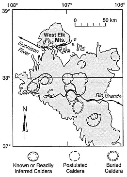
Fig. 4.16
Calderas of the San Juan volcanic field in
Colorado, showing overlap and clustering of
calderas. For every caldera, there is a large-
volume sequence of ignimbrites within
and surrounding it.
(Adapted from Steven et al ., 1974.)
Latera Volcanic Complex
The Latera complex, consisting of a 10- by 8-km caldera that is oriented north-northeast to south-southwest, lies adjacent to the much larger Bolsena Lake, which may also be a caldera. The complex's oldest volcanic rocks are between 0.9 and 0.4 Ma (Barberi et al ., 1984). Sparks (1975) felt that both Latera and Bolsena are calderas because of their shapes and their association with nine major and six smaller ignimbrites.
At Latera, the most voluminous pyroclastic flows were erupted 0.4 million years ago. It is possible there were multiple collapses of the caldera; this theory is consistent with the presence of multiple ignimbrite units that range from 0.3 to 0.15 Ma. Figure 4.18 shows
Fig. 4.17
Comparison of a young caldera (Valles/Toledo), its active hydrothermal systems, and its surface acid
alteration zones with two older, eroded calderas (Platoro and Lake City in Colorado), their intrusions,
and zones of hydrothermal alteration. In all three calderas, most of the hydrothermal activity has
taken place along faults within caldera-fill deposits and above lobes of an intrusion.
(Adapted from Smith et al . 1970, Dondanville, 1978, and Lipman 1975; 1976b.)
the pyroclastic rock sequences exposed on the flanks of Latera; the sequences consist of interbedded surge deposits and massive pyroclastic flow deposits that include lag breccias. These tuffs are composed of very fine grained ash, which is now altered to clays, zeolites, and iron oxides. The vesiculated tuffs and abundant accretionary lapilli present are all indicators of phreatomagmatic activity. Lithic clasts within the tuffs include metamorphosed mudstones (flysch), trachyte, marble, and tephrite.
Strombolian and Vulcanian eruptions followed caldera collapse within and along the caldera margins. D. De Rita (personal communication, 1985) indicated that Latium volcanoes with a history of phreatomagmatic volcanism during caldera formation followed by magmatic volcanism (in this case, Strombolian activity that formed cinder cones) eventually develop hydrothermal systems of the greatest geothermal resource potential. Intensive hydraulic fracturing may accompany phreatomagmatic eruptions when the main source of fluid is groundwater (see discussions in Chapter 2). This activity creates a large-volume system of fractures that, when associated with a thermal source, can become a hydrothermal system.
To test the observations described above, 14 geothermal wells had been drilled into Latera caldera, one of the Latium volcanoes, by 1985. Latera caldera deposits, which range from 250 to 1500 m thick, consist of coarse tuff-breccias and interbedded pyroclastic rocks and lavas (perhaps megabreccias). The caldera is filled with mostly pyroclastic material erupted during the first caldera-forming activity, as is depicted in Fig. 4.19. The caldera tuffs contain up to 50% basement lithic clasts (flysch). Several geothermal wells have been drilled into the carbonate sequence along a structural high located on the eastern caldera margin. Barberi et al . (1984) reported that they encountered a syenite intrusion—potassium-argon data indicate that it is ~0.86 Ma—close to the caldera center, at depths of between 2000 and 2700 m. This intrusion into carbonates underlying the caldera is marked by a thermometamorphic aureole that contains garnet, idocrase, diopside, and phologopite. The thermally metamorphosed rocks are strongly fractured, and the fractures are partly filled with anhydrite, calcite, epidote, and hydrogarnet.
Of the 14 wells drilled in the Latera caldera, 9 are producing hot water and steam from limestone reservoirs and fractures in the overlying flysch units. The temperature is 150°C at a depth of 1 km, and 210 to 240°C at depths of 2 to 3 km. The production wells are located primarily within the area of youngest caldera collapse where basement rocks are highly fractured.
Baccano Caldera
Baccano caldera is one of several calderas, cones, and maar volcanoes of the Sabitini volcanic complex, which has developed within a graben. Figure 4.20 shows the concentric normal faults that bound a low depression 4 km in diameter. Baccano may be located within the older Sacrofano caldera. The eruption and accompanying collapse of the Baccano caldera occurred, perhaps in stages, during multiple hydromagmatic events between 0.36 and 0.08 Ma. Most of this activity was phreatomagmatic; the water was probably supplied from aquifers in limestones underlying the caldera or from nearby Lake Bracciano.
Ignimbrites and surge deposits are exposed on the caldera rim and outer slopes, where they overlie an 85,000-year-old travertine deposit. The ignimbrites consist of small pumice clasts with accretionary coats of fine ash in a matrix of very fine ash. The surge deposits are rich in mineral clasts and subrounded lithic clasts (phonolitic lava, mudstone, and limestone). All of the pyroclastic deposits are partly altered to clays.
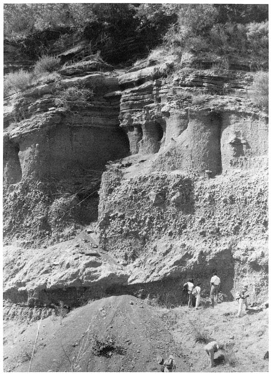
Fig. 4.18
Photograph of the pyroclastic sequence along the flanks of Latera Volcano in Italy, which consists of
interbedded scoria fall, surge, and ignimbrite deposits. The outcrop, along Poggio della Valicella,
follows the western shore of Bolsena Lake.
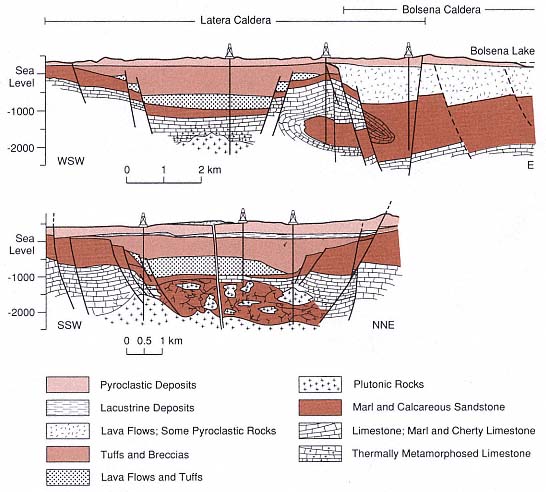
Fig. 4.19
Interpretative cross sections of the Latera and Bolsena calderas in Italy. The caldera-forming
eruptions of these calderas had a large phreatomagmatic component as a result of magmas
interacting with groundwater within permeable limestone units underlying the volcanic field. The main
hydrothermal reservoirs are located within the sedimentary rocks (mostly limestones) beneath
Latera caldera and along one margin within a horst. Cross sections are based upon geologic mapping,
geophysical surveys, and drilling samples. The magma body that provides heat to the hydrothermal
system was intersected by drilling below the center of Latera caldera.
(Adapted from Barberi et al ., 1984.)
Four geothermal wells (C-1 to C-4), with depths of 1400 to 3000 m, have been drilled within the Baccano caldera (Funiciello et al ., 1979). Temperatures of 300°C were measured in drillholes at depths of 3 km. Underlying the caldera are shales, marls, sandstones, and limestones of Middle Cretaceous age; Miocene flysch deposits; Upper Triassic to Oligocene carbonates, including marls, limestones and interbedded chert; and Triassic black limestone. The main hydrothermal reservoir is located in fractured carbonate rocks under a cap of the shaly rocks of the argille scagliose (a thick sheet of chaotic, slickensided clays that was displaced along low angle faults). The reservoir
consists of mixed hydrothermal fluids and shallower groundwater within the caldera deposits (Calamai et al ., 1976).
The Phlegrean Fields in Italy
One of the Earth's more famous volcanic fields is the Phlegrean Fields (Campi Flegrei), which lies adjacent to the city of Naples and forms not only much of the margin of the Bay of Naples but also part of the Campanian Plain. Nearly all the volcanism there has occurred during the past 50,000 years and most of it has been phreatomagmatic. Trachytic magmas rose to the surface to mix with groundwater and/or sea and lake water; this interaction produced volcanic forms that range from small tuff rings to the Phlegrean caldera complex. The information for the following discussion was condensed from papers and reports by Barberi et al . (1978), Cameli et al . (1976), Rosi et al . (1983), Lirer et al . (1987), and Rosi and Sbrana (1987) as well as unpublished work by G. Orsi.
One of the major events in this area was the eruption of the Campanian Ignimbrite 32,500 years ago (Paterne et al ., 1988). This widespread ignimbrite, chemically zoned from phonolite to trachyte, is believed to have had a volume of ~80 km3 (dense rock equivalent). Barberi et al . (1978) and Rosi et al . (1983) proposed that caldera collapse during this eruption left a crater 13 km in diameter that covered what is now the Phlegrean Fields and a portion of the Bay of Naples (Fig. 4.21). Authors have referred to this caldera complex as the "Campanian Ignimbrite caldera" and the "Phlegrean caldera," which we use here. Caldera-fill deposits range from 500 to >3000 m thick and consist of tuffs, tuff-breccias, and nonwelded pyroclastic rocks; these deposits may be partly the Campanian Ignimbrite and partly tuffs from younger explosive eruptions that are interbedded with conglomerates and sandstones (Bruni et al ., 1983).
More recent geophysical research by R. Scandone (personal communication, 1990) interprets a negative gravity anomaly located on the Campanian Plain northeast of Naples near Mount Vesuvius as the source of the Campanian Ignimbrite.
The Neapolitan Yellow Tuff (NYT) and Gauro Yellow tuff (GYT), dated at ~12,000 years BP, are exposed over a large area surrounding the Phlegrean Fields and are also encountered in geothermal drillholes within the caldera complex. Lirer et al . (1987) proposed that the NYT eruption formed a smaller caldera, ~6 km in diameter, that is centered on the town of Pozzuoli and the Gulf of Pozzuoli. These tuff units resulted from the largest multiple, significant phreatomagmatic eruptions since that of the Campanian Ignimbrite. The caldera complex of the Phlegrean Fields is also most likely a composite structure that was formed during several eruptions.
Some of the younger rocks of the Phlegrean fields make up tuff rings, tuff cones, and scoria cones, for which crater diameters range from a few hundred meters to 2 km. The youngest eruption formed Monte Nuovo in 1568 AD, and structural resurgence of the caldera has continued intermittently throughout historical time. The latest activity—between 1970 and 1985 AD—affected much of the Phlegrean Fields. The maximum uplift (240 cm) was centered in the town of Pozzuoli; resurgence is believed to be the result of magma injection at shallow depths. Recent movements along active faults are common throughout the volcanic field. There are numerous surface manifestations of geothermal systems, including the fumaroles and acid alteration found at Solfatara Crater and numerous hot springs.
Drilling within the Phlegrean Fields has revealed a high-temperature hydrothermal system that developed within the siltstones and sandstones of prevolcanic rocks and the tuffs and lavas of the caldera deposits. Temperatures range from 335°C at a depth of 2.5 km to 420°C at a depth of 3.04 km, and the average thermal gradient is 150°C/km.
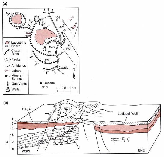
Fig. 4.20
Baccano caldera in Italy. (a) Structural sketch map showing the concentric ring faults around this
small caldera, flow directions of surge deposits and volcanic mudflows (lahars), caldera lake
deposits, and spring and well locations. (b) Cross section through the Baccano caldera (left) into the
larger Sacrafano caldera (right). The caldera is underlain by Mesozoic- and Cenozoic-age limestones
and marls (1 = volcanic rocks; 2 = Neogene-Pleistocene sedimentary rocks; 3 = Argille Scaglisose; and
4 = Mesozoic and Cenozoic sedimentary rocks. a = marl and limestone; b = limestone; c = limestone
and dolomite; d = anhydritic dolomite). Abundant groundwater and permeability within these
units probably provided the water needed for phreatomagmatic activity at Baccano.
(Adapted from Funiciello et al ., 1979.)
Fig. 4.21
The Phlegrean Fields of Campania, Italy. These maps are composites of those by Rosi and Sbrana (1987)
and Lirer et al . (1987). (a) Outlines of the Phlegrean and Neapolitan Yellow Tuff (NYT) calderas within
and around the Bay of Naples and the cities of Pozzuoli and Naples. Submarine topographic contours
are indicated in meters. (b) Volcanic-tectonic sketch map of the Phlegrean and NYT calderas
(the Phlegrean Fields), showing the location of all postcaldera craters and lava domes. Within the
Phlegrean Fields, most of the volcanic activity has been phreatomagmatic; the rising magma
has interacted with groundwater and sea water. The cross section in (c) is based mostly on
data from the deep geothermal wells noted on this map.
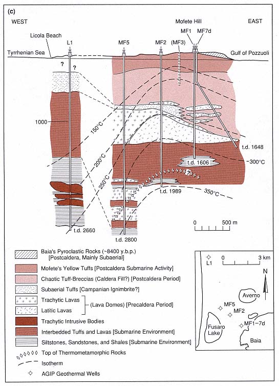
Fig. 4.21
(c) Cross section of the Mofete
geothermal area of the western Phlegrean caldera. The "chaotic tuff-breccias" and
"subaerial tuffs" could be caldera-fill materials that were
deposited during the eruption of the Campanian Ignimbrite.
(Adapted from Rosi and Sbrana, 1987.)
Hydrothermal fluids have risen along the faults bounding caldera structures and those that cross the volcanic field [Fig. 4.21(c)]. With the exception of fluids that rise along these faults, hydrothermal activity has been restricted to deep caldera fill, as is evident from the observation that the upper 500 m of pyroclastic deposits are not altered. These deposits overlie thick zones composed of argillic and illitechlorite alteration products. Hydrothermal fluids circulate within intensely fractured rocks near the caldera center, whereas low vertical permeability is characteristic of the outer caldera margins. Nearly all hydrothermal circulation within the caldera takes place within areas that have fracture permeability. There is no formation permeability except within near-surface aquifers. Thermally metamorphosed tuffs, sandstones, and lavas were found in the deepest wells, where rocks have been replaced by amphibolite-biotite and diopside, scapolite, garnet, and epidote. Similarly metamorphosed rocks have been found as lithic clasts within tuff units of the Phlegrean Fields.
In the Mofete geothermal field located near the western edge of the Phlegrean caldera, Carella and Guglielminetti, (1983) identified three water-dominated reservoirs in which water is the continuous, pressure-controlling system and there is little vapor [Fig. 4.21(c)]. The deepest reservoir, at a depth of 2700 m, contains hypersaline fluids at a temperature of 360°C; the intermediate reservoir, at a depth of 1900 m, contains low-salinity fluids at a reservoir temperature of 340°C; and the shallowest reservoir, between 500 and 1500 m deep, contains low-salinity water at temperatures of 230 to 308°C. The two deep reservoirs are located within thermally metamorphosed pyroclastic and epiclastic deposits; whereas the thick, shallow reservoir is sited within fractured volcanic rocks—mostly lavas—and is capped by tuffs that have been altered to clays.
Taupo Volcanic Zone in New Zealand
Geologic Setting
The Taupo volcanic zone (TVZ) of the North Island of New Zealand is a 250- by 60-km zone of young silicic and andesitic volcanoes that occupies a north-northeast-trending structural depression. The TVZ consists of offshore andesitic composite cones to the northeast, a central section containing at least six caldera complexes, and a southern center consisting of andesitic composite cones. The central part of the TVZ, which is ~125 by 60 km, is mostly made up of silicic calderas and has a geothermal resource of ~2000 MWe Donaldson and Grant, 1978). An assessment of the geothermal resource potential for individual fields in the TVZ is presented in Table 4.2.
The central section of the TVZ reaches elevations of 300 to 600 m and the depth to basement within the graben is 500 to 1000 m below sea level (Healy, 1982). The basement is even lower below the calderas themselves. Rogan (1982) found steep gravity gradients at the TVZ margins and conservatively estimated that the volume of tuffs, lavas, and associated sedimentary rocks within the central TVZ is ~12,000 km3 . Much of the activity responsible for this erupted material occurred during the past 1 million years.
The calderas of the TVZ have been favorable targets for geothermal drilling and development for many decades, but comprehensive volcanological studies of the calderas are more recent (for an excellent summary paper, see Wilson et al ., 1984). We chose to discuss here the well-known Wairakei geothermal field, which is the site of one of New Zealand's largest geothermal generating plants.
| ||||||||||||||||||||||||||||||||||||||||||||||||||||||||||||||||||||||||||||||||||||||||||||||||||||||||||||||||||||||||||||||||||||
Maroa Volcanic Center and Wairakei Geothermal Field
The Wairakei geothermal field is located along the common boundary of the Maroa and Taupo volcanic centers, following north-northeast-trending faults that cross both centers (Fig. 4.22). Maroa has a negative gravity anomaly that Rogan (1982) modeled as a 15- by 10-km basement depression with a volume of 250 km3 below the local base level (-1000 m). Wilson et al . (1984) used magnetic data to interpret the presence of thick caldera deposits in the area.
The Maroa center has developed during the last 250,000 years. Its oldest rocks, the rhyolitic domes of the Western dome belt, appear to have erupted along a basement graben during the same time period in which the central dome complex was erupted. The basin is filled mostly with interbedded rhyolite lavas and poorly to nonwelded ignimbrites. Domes exposed at the surface form north-northeast-trending clusters that are parallel to the normal faults of the area [Figs. 4.22 (a) and (b)] and overlap domes of the Taupo volcanic center. The youngest eruption, (14 to 15 ka) was a small, partly
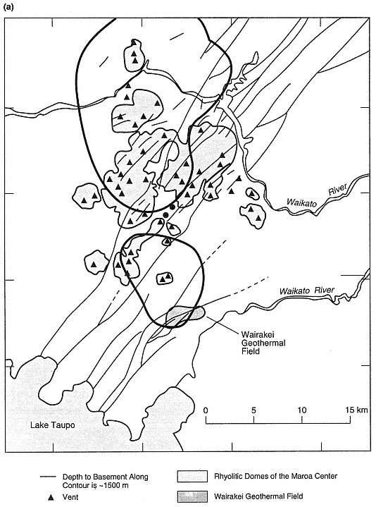
Fig. 4.22
(see also pages 173 and 174) Maroa volcanic center and Wairakei Geothermal field in New Zealand.
(a) Simplified geologic map showing the location of the two basins (calderas?). Depth to basement
along contour line is ~1500 m. The Wairakei geothermal field and rhyolite domes of Maroa are shown.
(Adapted from Wilson et al ., 1984.)
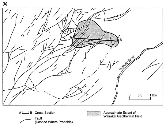
Fig. 4.22
(b)Structural map of the Wairakei geothermal field shows location of the cross-section depicted in (c).
(Adapted from Grindley, 1965)
phreatomagmatic eruption; this explosive activity was followed by a dome eruption. The summary of eruption activity presented in Table 4.3 was compiled by Wilson et al . (1984).
Within the Wairakei geothermal area, ignimbrites and associated rocks thicken from west to east and into a depression bounded by fault scarps. The area now defined as the Wairakei Basin is part of the Maroa volcanic center. The Wairakei Ignimbrites described by Grindley (1965) are more than 520 m thick and consist of several sheets separated by "pumiceous sediments" (perhaps pumice fallout or surge deposits). Grindley also reported that the younger Huka Group, which Wilson et al . (1984) called the Maroa-derived ignimbrites, includes sequences of "pumice breccia," ignimbrites, phreatomagmatic tuffs, and tuffaceous lacustrine sedimentary rocks. This group thickens from 713 m—over the Wairakei fault-bounded horst—to >1.2 km in the Wairakei Basin [Fig. 4.22 (c)]. Overlying the Huka Group is the "Wairakei Breccia" (Grindley, 1965), which was renamed the "Wairakei Formation" by Self and Healy (1987); these deposits, erupted 20,000 years ago, consist of pumice falls, fine-grained ashfalls, and nonwelded ignimbrites.
The rhyolite domes of the Central Dome Complex and the Maroa-derived ignimbrites have been intersected by drillholes along a northeast-trending line from the western perimeter of the Wairakei geothermal field toward the Central Dome complex visible at the surface. The domes are interbedded with tuffs of the Maroa-derived pyroclastic rocks, and the entire section is overlain by thin deposits of the youngest Taupo ignimbrites.
The greatest hydrothermal activity is located along a 3.2- by 3.2-km northeast-trending horst, which is close to the boundary between the Taupo and Maroa volcanic centers. Grindley (1965) found that much of the geothermal fluid movement is along deep-seated faults running parallel to major horsts and grabens (Fig. 4.22b). Some phreatic craters are also located along fault traces. The greatest permeability is found along fault zones, although there may be some formation permeability within non-welded ignimbrites. Drilling along these faults has intersected hydrothermally altered fault breccias that are cemented by hydrothermal minerals. At Wairakei, the most productive wells are sited on the downthrown side of surface fault traces, whereas wells sited on the upthrown side were less productive (Grindley, 1965). Wells drilled away from faults encountered impermeable, cemented pyroclastic rocks and did not produce geothermal fluids.
There is some difference of opinion about the origin of the Maroa and Wairakei basins. Grindley (1965) interpreted them as volcano-tectonic, with emphasis on the tectonic aspects. On the other hand, Wilson et al . (1984) interpreted the center as a caldera that underlies the central rhyolitic dome complex; these authors comment, however,
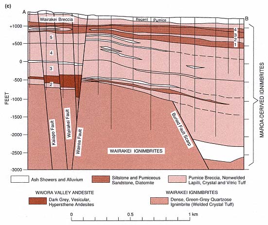
Fig. 4.22
(c) Cross-section through the Wairakei geothermal field, showing increasing thickness of the
Maroa-derived ignimbrites into the Wairakei basin.
(Adapted from Grindley, 1965.)
that there is little surface evidence for such a caldera complex. By examining the data presented by both sets of authors, it is possible to come up with at least one additional interpretation that is based on several points.
· Depths to basement presented by Wilson et al . [Fig. 4.22 (b)] indicate the presence of two overlapping basins: the Wairakei, with a depth to basement graywacke of 2000 m, and the unnamed basin below the central dome complex, with a depth to basement of 2500 m.
· The variety of ignimbrites and associated rocks (the Maroa-derived ignimbrites described by Wilson et al . and the Huka Group and Wairakei Ignimbrite referenced by Grindley) that thicken into the Wairakei basin could be evidence for multiple ignimbrite eruptions and associated caldera collapse.
· There are multiple overlapping calderas in the Maroa volcanic center and two of them correspond to the basins defined by depth to basement.
Whichever the interpretation of the history and makeup of the Maroa volcanic center one accepts, all the indicators for the presence of a geothermal system are here: surface manifestations (including phreatic craters, hot springs, and fumaroles), numerous normal faults, multiple young ignimbrite units, and young silicic domes and flows.
| ||||||||||||||||||||||||||||||||||||||||||||||||||||||||||||