A New Landscape Deal
Eckbo held one of the positions of landscape architect at the San Francisco FSA office (Regions IX and XI) from 1939 until 1942. Vernon DeMars became acting district architect, after the death of Burton Cairns; Herbert Hallsteen was district engineer and Nicholas Cirino, regional engineer. Their official goal was to design the physical framework for shelter, sanitation, education, and care for migrant workers across the western states. The majority of these camps were established in California, which, with its extensive mechanized agriculture and the vast influx of migrant laborers, required the most intensive relief efforts. Thus, the San Francisco office planned communities for Ceres, Gridley, Winters, Thornton, Westley, Firebaugh, Mineral King, Tulare, Shafter, Arvin, Brawley, Marysville, Yuba City, and Coachella. Other sites included Walla Walla, Granger, and Yakima in Washington; Yamhill in Oregon; Caldwell and Twin Falls in Idaho; Yuma, Glendale, Agua Fria, Chandler, Casa Grande, Eleven-Mile Corner, and Baxter in Arizona; Weslaco, Harlingen, Robstown, and Sinton in Texas. As a norm across the states, landscape design concentrated on providing
shade, preventing erosion and dust, and ultimately—to cite Eckbo—expanding and framing the architecture.[22]
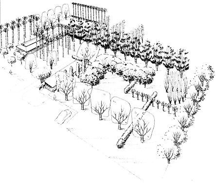
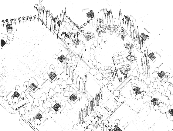
Economic, social, and climatic factors determined the planning of home, trailer, and tent communities for permanent, semi-permanent, and transient residents [figure 93]. The permanent section of the camps housed between one and three hundred occupants; the temporary areas needed to accommodate up to a thousand migrants, who lived in metal shelters—usually replacing the platform-tent units of the early camps—or trailers. The transients' area of the camp was arranged in a linear block pattern, hexagons, or double hexagons, to allow continuity of circulation within controlled borders. In contrast, the permanent residents lived in individual houses or multi-family housing that formed distinct neighborhoods. The site plans usually organized the homes in cul-de-sac pattern and staggered the one- or two-story apartment units to idealize orientation to sun and wind and to ensure privacy. The inhabitants of both houses and apartments maintained private subsistence plots. The park, sports, and recreational facilities complemented the community buildings, usually located close to the temporary residents' lodgings, where the demand for such amenities was greater [figure 94].[23]
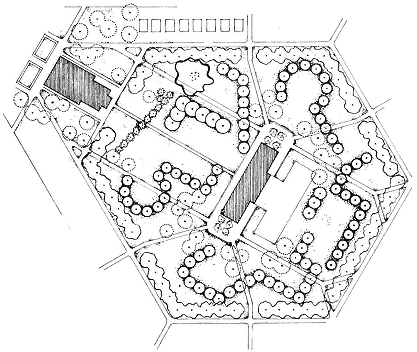
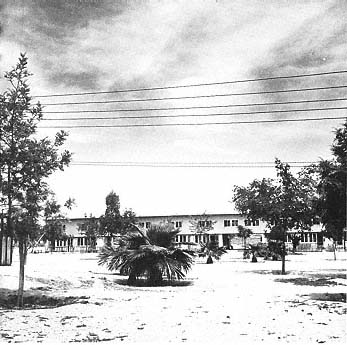
94
Tulare Unit; central open space for the trailer camp. Site plan.
Tulare Basin, San Joaquin Valley, 1937–42. Farm Security Administration.
The assembly hall is at the right of plan with the utility building at left.
[Documents Collection ]
During his FSA years Eckbo experimented with what he termed the "assembly-line-technique" of modern site planning. Site planning integrated all aspects of design, a means to approach the expansive as well as the restrictive nature of landscape. He wrote that comprehensive study was needed to determine the best possible relationships among buildings, utilities, recreation facilities, planting, and open space. Thus, cohesive site planning, regardless of scale should be the "arrangement of environments for people." Its ultimate goal was to "produce the best possible physical pattern within which a group of people can develop a good social pattern."[24] Eckbo described gardens as forming spaces in which the structural elements of ground plane, enclosure, and canopy were interdependent and equally important.[25] But ultimately, the raison d'être of landscape design was to provide a setting for human activity, and the migrant camps were no exception.
The creation of diverse outdoor spaces defined with enclosures of varying heights and density—paired with amenities—fostered social exchange, during "free play" or games of baseball, in hanging laundry or dancing [figure 95]. The park, addressing the community building, served as an outdoor extension for the functions taking place inside—shaded and sheltered from the wind—and as the common green for the garden-less trailers surrounding it and for the colony as a whole. With the active practice of religion officially discouraged by the camp's "constitution," recreational activities would provide the arena for communal interaction.
As Eckbo observed in his article on design in the rural environment, the grouping of agricultural communities offered social and recreational advantages as well as those of cooperative economy: "whereas in the cities the need is for more free space (decentralization)," he wrote, "the rural need is for more intensive use of less space (concentration)."[26] The frontier model of the homesteader—in which the family stood as both the social and the recreational unit—needed revision. So did rural housing and rural recreation. The expansion of territory and scattering of population that characterized the industrialization of agriculture made social contact more essential than ever. Productivity may be a key element in the organization of a rural area, wrote Eckbo, but it still should rely on the understanding of the physical as well as cultural aspects of that area. Hence the need to grasp
95
Ceres Camp. Community recreation space. San Joaquin Valley, 1940. Farm Security Administration.
"Large tree patterns at the baroque scale of cheap rural land."
[Documents Collection ]
the importance of a well developed local road network, in addition to the interstate highway system, of grouped rural housing, and of organized recreation.
Rural recreation may be too novel a field to have established standards, Eckbo continued, but its facilities should foster group activities and competition, including concerts, dance, sports, and drama. But standards did exist, as evidenced by the three-volume Park and Recreation Structures published by the National Park Service in 1938. Formally, these campsites and facilities had little in common with Eckbo's take on the rural landscape—as they complemented forested natural beauties with rustic buildings and campfire circles. Furthermore, their aim also differed, in that the National Park tent and trailer campsites accommodated voluntary, and most likely urban, dwellers and not agricultural refugees. Despite their rather pastoral image, the National Parks exerted some form of control as "the tent camper seem[ed] to exercise (and to get away with!) an inversion of the right of eminent domain. He [held] any attempt to regulate his tenancy and conduct in the public interest to be ultra vires and inhibiting of his ruggedly individualistic prerogatives."[27] It was this very rugged individualism—generally associated with the frontier spirit of farmers—that appears to have warranted the strict arrangement, the supervising administration, and constitution of the FSA settlements. Instead of a layout of cabins, dining lodges, craft shops, and wash houses scattered amidst groves of trees by the Civilian Conservation Corps, the architecture and landscape architecture team of the San Francisco FSA office favored a highly hierarchical plan more akin to the Renaissance new town than to any "delightful informality" so scorned by Eckbo. The latter considered that "we may as well accept the fact that man's activities change and dominate the landscape," although adding, "it does not follow that they should spoil it."[28] Thus he would look toward the ordered patterns of agriculture as theaters for, and models of, design interventions.
Eckbo stated once again his sympathy for a formed landscape, arguing that the "romantic informality" of the countryside was a concept that had long needed overhauling; agricultural fields did not "'blend' with nature" but instead showed human organization of nature. Then,
he concluded, "whence . . . the theory that landscape and building design must go rustic in the rural areas."[29] To sustain his argument, he utilized the modernist architecture of the FSA camps as a possible model for rural housing. Part-time farm colonies that promoted sustainability, such as Chandler, had an edge over the camp dependent on, and an appendage to, the agricultural industry—a trend Carey McWilliams saw as encouraging, if only as a signpost on the road to reform. To McWilliams,
the real solution involves the substitution of collective agriculture for the present monopolistically owned and controlled system. . . . A partial solution will be achieved when subsistence homesteads have grown up about the migratory camps. . . . It is just possible that [the] latest recruits for the farm factories may be the last, and that out of their struggle for a decent life in California may issue a new type of agricultural economy for the West and for America .[30]
The FSA did attempt to stabilize migration patterns within various states. The highly specialized agricultural industry tended to employ a large seasonal labor force that rural communities could not absorb year-round. The relief administration thus experimented with variable-geometry or variable-demography settlements whose plans evolved from sports fields and vice versa. The camp of Woodville, located among the cotton, grapes, asparagus, and citrus fields of the lower San Joaquin Valley of California, was planned as the nucleus of a new small town. The aim was to retire the camp as the seasonal users were replaced with permanent residents—should additional employment arise. Located on a flat bare site, Woodville was praised by architectural critics for the quality of its planning as well as for the design of its community buildings [figure 96].[31] The arrangement balanced the temporary metal shelters with single and row houses that recalled those erected at Yuba City. Lavatory, laundry, and shower facilities served the migrant residents—constituting three-quarters of Woodville's population—while the co-op store, school, and community building joined camp and "town" areas. The tri-alar school and community building was a lesson in economy and flexibility: low prisms linked by exterior corridors opened the various classrooms directly to agricultural fields and orchards; with the assembly room
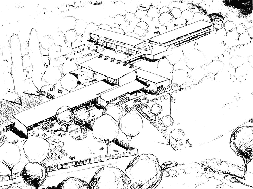
96
Woodville school and community center. Aerial perspective.
Tulare Basin, San Joaquin Valley, 1941. Farm Security Administration.
[Courtesy Garrett Eckbo ]
doubling as the school gymnasium, the complex furnished "areas for child instruction, adult instruction, recreation, and social gatherings, adjustable to almost any use."[32]
Elizabeth Mock, curator of Architecture and Design at New York's Museum of Modern Art, assessed Woodville's "handsome buildings [as] the result of careful and economical design: FSA 's San Francisco office has shown that 'bureaucratic architecture' can also be distinguished."[33] The placement of the gatehouse beyond the center and homes area, "in control of the camp section only," so as "to remove any suggestion of a Government reservation," was perhaps an indicator of the social hierarchy within the settlement itself.[34] In their time-axis conception, such camps reflected similar patterns as those of immigration, for example, the recent arrivals pushing the lower strata upward.[35]
To complement such "touch[es] of European modern [architecture] in the western landscape," Eckbo sought an optimal structuring of outdoor spaces with planting patterns that were distinctly his own [figure 97].[36] At Weslaco, Texas, he designed a dozen variations for the park addressing the gatehouse and garage with modifications of the "grass-shrub-tree relationship."[37] All schemes, modular yet varied, bore a close resemblance to modern art, with formal manipulations of green elements—lines, arcs, and free forms [figures 98–99]. With outdoor rooms, suggestions of enclosure, and rhythmic punctuations of spaces, Eckbo followed the dictum of "blocking off portions so there is a succession of views and to set up movement and circulation."[38]
Throughout his landscapes, he formed space by arranging the elements of surfacing, enclosure, and "enrichment"—that is "pictures, 'compositions,' patterns [and] flower borders." With "enrichment" limited by economic or practical constraints, his equation relied on the possibilities offered by "sensitive and imaginative selection and arrangement of enclosure and surfacing elements." He saw this option as "equally satisfying with no more than the greatest enrichment of all—human life and activity."
Eckbo frequently asserted that open space should be considered the skeleton and controlling form of the site plan, rather than the by-
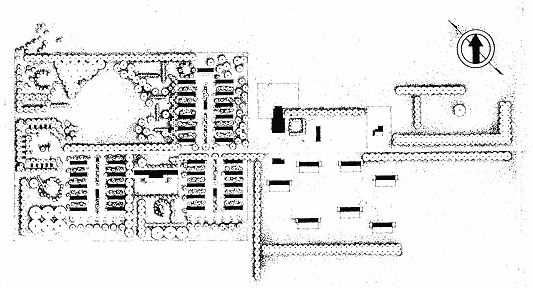
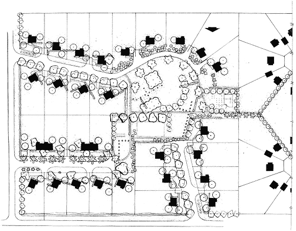
97
Weslaco Unit. Site plan. Texas, 1939. Farm Security Administration. Photostat.
Buildings in upper center frame the site of Eckbo's alternate park schemes, shown at left and opposite.
[Documents Collection ]
98
Weslaco Unit. Park for community building and gatehouse/garage.
Aerial perspective. Texas, 1939. Farm Security Administration. Ink on tracing paper.
[Documents Collection ]
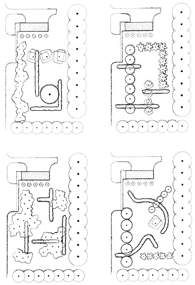
99
Weslaco Unit. Park for gatehouse/garage. Four of twelve plan variations.
Texas, 1939. Farm Security Administration. Ink on tracing paper.
[Documents Collection ]
These studies indicate "the potential variety of grass-shrub-tree
relations which can be developed beyond the standard interpretation
of meadow." [ from Garrett Eckbo , Landscape for Living]
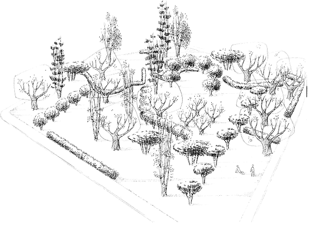
100
Mineral King Co-operative Ranch. Community park. Aerial perspective. Near Visalia, Tulare Basin,
San Joaquin Valley, 1939. Farm Security Administration. Ink on tracing paper.
[Documents Collection ]
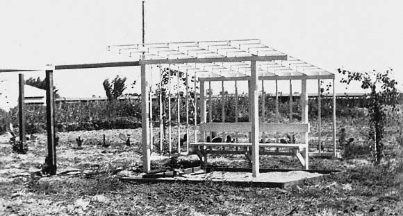
101
Shafter Unit. Shelter/play structure. Tulare Basin, San Joaquin Valley, 1937–41.
Farm Security Administration. Note the combination trellis/bench/sandbox.
[Courtesy Garrett Eckbo ]
product of the buildings arrangement and roadways.[39] As he entered the FSA office relatively late in the operation of the program, however, his major planning investigations were directed toward the design of the parks for permanent homes rather than the overall layout of camps [figure 100]. Built on federal land, the settlements were beyond the control or harassment of state and county agencies, and by private militias. Intended to protect—if not isolate—the residents from the environment and social tensions, the camp design attempted to create a climatic haven and a sense of place for the transients. To counter the aridity and heat of the California valleys, Texas, or Arizona, Eckbo used plantings as shelter and as the spatial structure for life and play [figure 101]. Tree canopies or trellises countered the sun or functioned as outdoor rooms complementing the tent, trailer, or housing units. The allées, screens, and clusters of vegetation defined specific spaces assigned to specific functions: roads, drying yards, common play areas, or individual vegetable gardens. Praising the designs the San Francisco office produced for the migrant workers, the architectural critic Talbot Hamlin hardly commented on the formal landscape improvements, but he remarked on the attention given to, and the necessity for, vegetation:
In all of this site planning the problem has been seen as a human and as an aesthetic problem as well as a problem in serving practical ends. Thus the most careful use has been made of existing trees, and where definite groves or stands of timber exist on the property these areas have been chosen wherever possible for the community buildings, the schools and the more permanent houses, so that the migrant driving in dusty after a day's work in blazing shadeless field or a long run over sunbeaten and windswept highways may find his relaxation in a place dappled with leaf shadows, embowered with trees and with the heartening feel of green and growing things around. Moreover, tree planting and a certain amount of modest landscaping has formed an essential part of all the communities .[40]
The site plan of the camp at Taft favored a centripetal arrangement in which the two-story units not only sought the best orientation but also formed a visual closure that served as a "sheltered oasis" [figure 102]. Heavy plantings of hardy species such as black locust, Siberian
102
Taft Defense Housing. Central open space. San Joaquin Valley,
1941. Farm Security Administration.
[Courtesy Garrett Eckbo ]
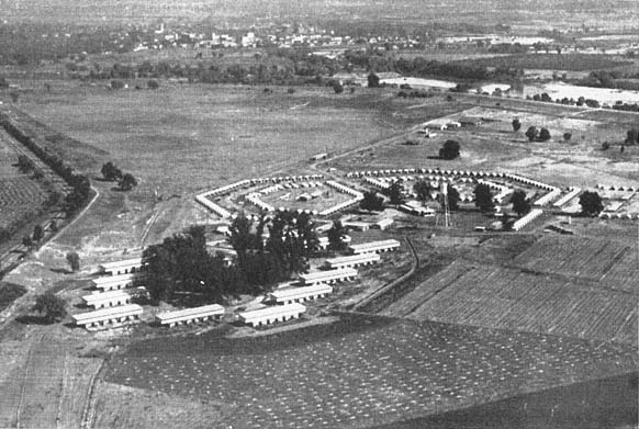
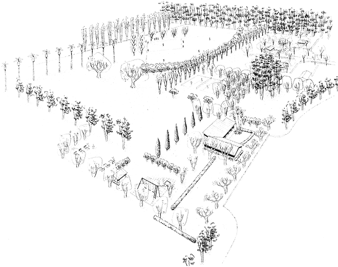
103
Yuba City Unit. Aerial view. Sacramento Valley, 1937–39. Farm Security Administration.
Housing for permanent residents surrounds a grove of existing trees, in the foreground,
with the double hexagon of the migrant workers' trailer camp beyond.
[ from Architectural Forum]
elm, and coast beefwood withstood the extreme temperature range and dry climate of the San Joaquin Valley and structured the landscape scheme.[41] Highly tolerant of wind, drought, and poor soil conditions, these trees were also extremely fast-growing if irrigated. Such perfect subjects for soil conservation or land reclamation fought wind erosion by providing excellent windbreaks and shelter belts. In addition to creating express landscapes in deserts, Eckbo also relied on, or supplemented, vegetation present on the site. His interventions could be thus defined as either adaptations , the creation of oases within the harsh environment; insertions , when he complemented the landscape with a reinforcing vegetal structure; or appropriations , when he integrated entire groves of existing trees to his scheme [figures 103–4]. The planting plan of Winters, west of Sacramento, combined the latter two modes, as Eckbo laid out the Farm Labor Homes within apricot and walnut orchards and subverted their formal order with hedges, groves, and lines of hackberry, Chinese pistachio, and Chinese elm.
Eckbo described plantings not only as providing shade, greenery, color, and general amenity but also as the final refining element in the complete spatial design of the site. The landscape architect should collaborate with the architect and the engineer on site planning from the very beginning, wrote Eckbo, "if he is to be saved from the fate of being an exterior decorator for architecture. The keynote of the planting scheme should be the use of plants as space-organizing elements rather than as decoration."[42] Spines of trees offered protection from wind while enclosing spaces such as baseball fields or other play areas, reinforcing circulation patterns, and implying movement. Lines of shrubs also outlined outdoor rooms and multiplied view-points, thereby suggesting a continuation of space beyond the actual boundaries of the park.
For inspiration, Eckbo saw no better source than the rural landscape itself—the congruence of people and nature.
[With] innumerable definite three-dimensional space forms produced with both structural and natural materials: rectangular or polygonal fields cut from solid natural wildwoods; trees in rows or belts forming planes; the regularity of orchards; straight lines of
104
Yuma Unit; multi-family housing. Site and planting plan. Arizona, 1939. Farm Security Administration. Photostat.
[Documents Collection ]
untrimmed hedges and mixed hedgerows . . . ; free-standing clumps of trees forming natural pavilions; intersecting planes of these lines of trees and hedges and walls forming a fragmentary organization of space. It is seldom completely enclosed; always there is a suggestion of its continuity, something to follow, the stimulating impossibility of seeing all of the space at once .[43]
The landscape design of the Shafter camp appeared as an interpretation of the standard agricultural fields [figure 105–6].[44] Each of the twenty-nine permanent home lots was sufficiently large to raise subsistence crops, a majority of indigenous trees structured the two-acre park, and in the play areas, the "light frame trellis-and-screen structures [stood as] abstractions of typical practical agricultural crop structures." Despite the stringent budget, Eckbo accorded great attention to the spatial definition of house and circulation areas. Announcing the later vegetation codings of postwar projects such as Community Homes, he drew three site plans keyed accordingly to the height of trees and shrubs.
The camps were located strategically along the migratory routes followed by laborers, and within proximity of employment, which allowed Eckbo to take advantage of the extremely rich soil of the Californian agricultural valleys. And being of the opinion that "it has yet to be proven that long plant lists necessarily increase costs," he planted heavily and variedly.[45] He sought to create "large tree patterns at the baroque scale on cheap rural land," using eucalyptus, palm tree, and poplar as the backbone of the layout; oak, olive tree, and magnolia to offer shade; and almond and plum trees for color [figure 107].[46] Thus the geometries that looked rigidly systematic in plan were offset in reality by the variegation of trees and shrubs. This sampling of vegetation could be seen as reminiscent of the gardens Eckbo designed for Armstrong Nurseries—a panoramic range of species that softened the formality of the basic planting schemes [see figures 5–7].
Although simple in manner, Eckbo's schemes for the FSA camps displayed a sophisticated spatial layering—both vertical and horizontal—that recalled the formal variations of his theoretical Small Gardens in the City of 1937. In the landscapes of relief, the lessons of modern architecture were translated into planting designs where architec-
105
Shafter Unit; farm labor homes for permanent residents, with park. Site plan.
Tulare Basin, San Joaquin Valley, 1941. Farm Security Administration. Ink on tracing paper.
[Documents Collection ]
106
Shafter Unit; farm labor homes. Axonometric drawing. Tulare Basin, San Joaquin Valley,
1941. Farm Security Administration. Ink and pencil on tracing paper.
[Documents Collection ]
107
Woodville. The edge of row housing. Tulare Basin, San Joaquin Valley,
1941 Farm Security Administration.
[Courtesy Garrett Eckbo ]
tonic screens were enlarged through vegetation. And these designs, destined for the lowest-income group, shared the same formal investigations as those of his avant-garde private gardens: a rare instance of aesthetics at the service of the expedient.
The shaping of camps into the hexagons of ideal town plans transcribed an inner political order—with its own constitution and higher committee. It revealed an order that strove for humanism against the outside world and its Red-bashing militias.[47] To promote communities that instigated social as well as economic rehabilitation, the architects of the New Deal attempted to create a miniature society whose naïveté in pursuing a democratic and collective spirit was matched only by its fondness for keeping rural folklore. If the first Roosevelt administration had been placed under the sign of planning, the great depression era coincided with the idealization of regionalism. In times of economic and social uncertainty, the longing for a more secure past and a sense of place typically holds the promise of a recoverable order. Perhaps the designs of FSA camps best expressed the tug-of-war between reform and relief, progress and tradition. Their manufacturers put forward the social ideals of modernism—both in landscape and architecture—as a tool for stabilizing the human drift across the land. Such projects acted not only as design exhibits but also as social beacons, as Paul Conkin concluded in Tomorrow a New World:
When a simple farmer, wide-eyed with wonder and expectancy . . . moved into a glittering new subsistence homesteads or resettlement community, he was entering a social show window. Willingly or unwillingly, knowingly or unknowingly, he was a human mannequin in a great exhibit, for the many architects of the New Deal communities, despite varying philosophies, were all striving to create, within the conducive environment of their planned villages, a new society, with altered values and new institutions .[48]
Eckbo's plantings evoked the order of, or sometimes borrowed from, the surrounding orchards; they also superimposed agrarian references and the indigenous with the forms of functionalism and exotic species. More often than not, however, Eckbo subverted the hermetic and controlling order of the camp. At Tulare, the hexagon-forming shelters addressed on one side the grid of an existing wal-
nut orchard and on the other the central open space with its utilities building and assembly hall [figure 108]. The park itself appeared to draw more from patterns of paintings by László Moholoy-Nagy or Kasimir Malevich than from any rural precedent. The dynamic diffractions of space – with overlapping allées and green hemicycles—was enhanced by varied plantings. With the diverse scales and textures of tree of heaven, silver dollar gum, olive, camphor, and bottle tree, the eye of the hexagon seemed independent from the order of the camp. Within the trailer-bound ideal shape, Eckbo inserted another set of rules, just as formal but based on another geometry. Modifying the vertical scale and the degree of usual transparency between the patterns, he completely abolished any remnant of a Cartesian reading. Ultimately his order—totally alien to both surroundings and migrants—became the norm for the central spaces of many of the camps scattered across the west.
Urban, highly educated, secular young men oversaw the daily lives of rural, mostly non-educated, and frequently fundamentalist laborers from Arkansas and Oklahoma.[49] Similarly, in spite of Eckbo's claims that "the country must be redesigned for country people —i.e., neither from the viewpoint of nor for the benefit of the urbanite," his parks for the FSA were, most likely, alien to anything country people might have experienced before.[50] He did succeed in creating spatial identity—albeit architecturally derived, art-referential, and mostly highbrow—within the agrarian landscape of the West. His plantings, which appeared originally so diminutive when photographed next to the ready-made architecture of the camps, have now matured, and form ghost images of their social endeavor throughout the California valleys.
In spite of the higher ideal pursued in the creation of migrant camps—that of a new pattern of community life removed from an individualistic and materialistic society—the quantitative production of the FSA was deemed by many to be at best a stopgap solution. Not only did the sheer volume of exploited farm laborers living in squalor overwhelm the capabilities of the relief agency, but the assistance to migrants remained superficial rather than structural. The government-run camps functioned as a subsidy for farmers that relieved them of responsibility to provide housing or minimal wages.[51]
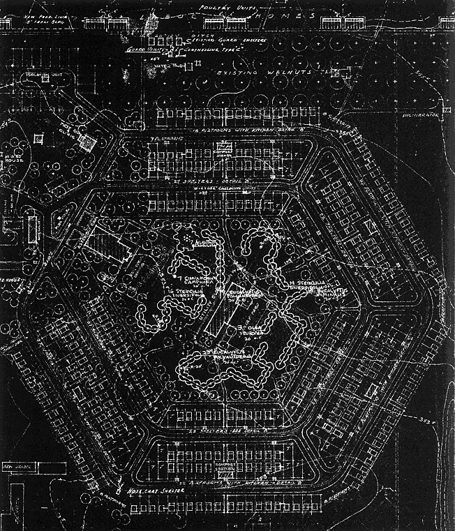
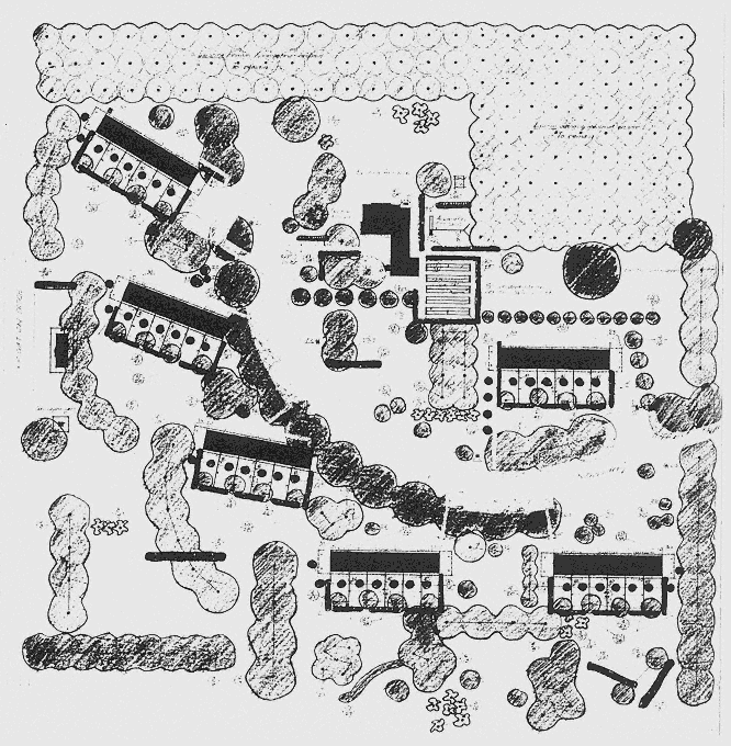
108
Tulare Unit. Site and planting plan, detail (12 December 1941). Tulare Basin, San Joaquin Valley. Farm Security
Administration. Blueprint. The shelters form a hexagon around the park; an existing walnut orchard lies between
the migrant section and the permanent residents' homes.
[Documents Collection ]
The results of such efforts, whose limited scope was perpetually threatened by agribusiness lobbies, are sadly summed up in today's migrant settlements, still inhabited by agricultural laborers—though of a different ethnicity [see plate II].[52] As Cletus Daniels concluded:
Farmworkers in California were poor, uprooted, and powerless people long before Franklin Roosevelt's voice crackled over the radio imploring middle America to have courage in the face of depression and promising a new order of prosperity and economic justice in the days and years ahead. And they were no less poor, uprooted, and powerless after the reformist enthusiasm of the New Deal had waned and the attention of the nation had shifted from domestic to foreign affairs .[53]