Illustrations
Urban Transportation
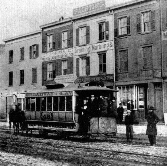
1. Horsecar, 4th Avenue near 10th Street, New York City, ca. 1865. The world's urban transportation revolution began with the introduction of horsecar service by the New York and Harlem Railroad in 1832. Twenty years elapsed before city growth caught up with the innovation, but, by the Civil War, streetcar tracks crisscrossed the streets of every major city in America. The standard specifications: two horses, a driver and a conductor; 40 passengers in comfort, up to 74 in a squeeze, five-cent fare; and an average speed of six miles per hour. New-York Historical Society
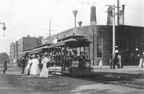
2. Cable Cars at 55th Street and Cottage Grove Avenue, Chicago, ca. 1902. Cable cars, introduced in San Francisco in 1873 to cope with its hills, in the 1880s moved heavy traffic along main streets leading to downtown in other cities. Horsecar networks stretched ten to fifteen miles from the city's center in a feeder system to the faster (ten to twelve miles per hour) cable lines, much as today suburban streets merge with superhighways. Unlike the high-speed highway, this modest innovation did not destroy abutting neighborhoods but rather nourished spines of apartments and stores along its routes. Library of Congress
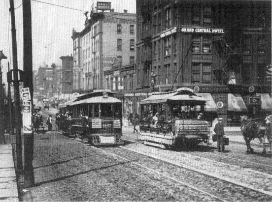
3. Electric Streetcars on Madison Street, Chicago, 1906. For a time, the electric-powered streetcar, first put into practical operation in Richmond, Virginia, in 1887-88, and introduced in every city during the nineties, seemed the answer to big-city traffic problems. Cheaper to install than cable lines and faster than the horsecar, it could reach suburbs, or be linked in tandem and scheduled in steady streams for the central city. Its major failing was its grinding gears and pounding steel wheels, which made it the enemy of sleep on summer nights, and an annoyance all year long. By raising the sound levels of urban streets to intolerable heights the streetcars drove the rich from their customary conspicuous locations on the city's main thoroughfares. Quiet isolation became a fundamental amenity in wealthy neighborhoods and the goal of middle-class homeowners. Chicago Historical Society
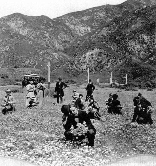
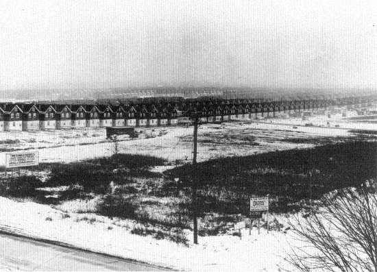
4. A Distant Streetcar Subdivision, Altadena, Los Angeles, ca. 1890. Twelve miles from the core city, then only 50,000 inhabitants, land speculators stretched their electric car lines beyond traffic demand in anticipation of house-lot sales. The automobile, traveling on publicly financed roads, freed land developers from such expenses, thereby perpetuating the small operator in city building. History Division, Los Angeles County Museum of Natural History
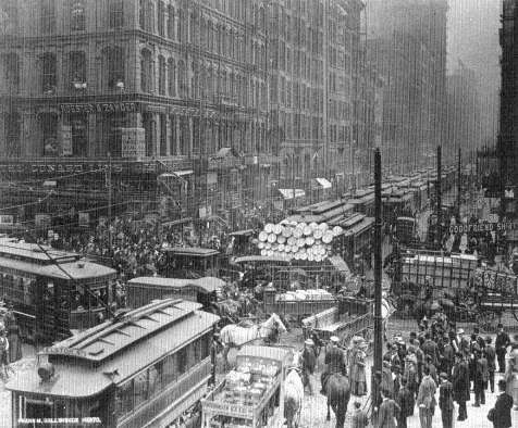
5. Downtown Traffic Jam, Dearborn and Randolph Streets, Chicago, ca. 1910. More and faster service, from horsecars to cable cars to electrics, brought greater downtown traffic and taller buildings. Chicago Historical Society
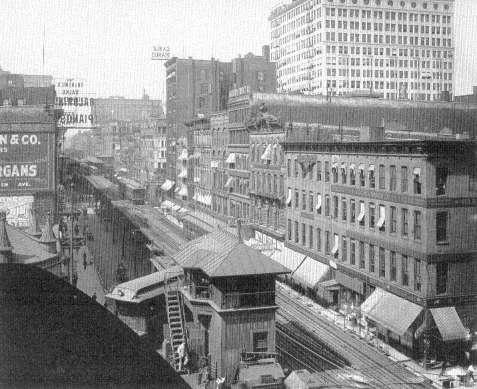
6. Wabash Avenue Elevated Railway, Loop, Chicago, 1907. For a brief period (in Chicago, 1892-1911) the pent-up demand for downtown shopping and business locations in the largest cities made it profitable for private firms to construct enormously expensive elevated networks. But an intown express was also an outbound express. The new els and the motor truck expanded options of location for many firms; thus the densest traffic jams in our cities' history led to the long and steady process of decentralization. Library of Congress
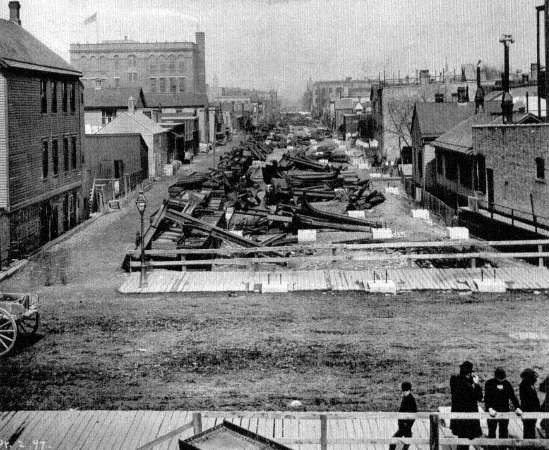
7. Elevated Construction, Willow Street near Sheffield Avenue, Chicago, 1897. Environmental choices for rapid transit were all bad. Who was to suffer the sensory destruction of darkness, noise, and dirt? The elevated placed the passenger in fresh air, above the noise, with an occasional spectacular view. Below, it spread a pall over the street, abutting houses, and workrooms. Here, a new elevated through a Near North Side working-class district. Chicago Historical Society
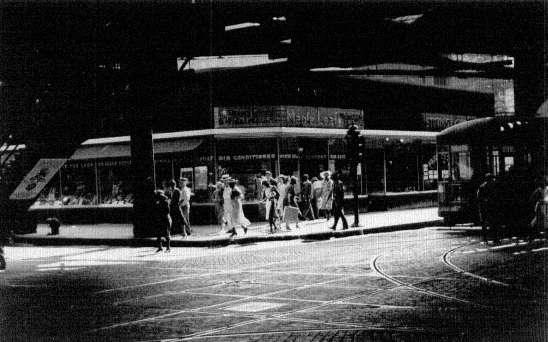
8. Underneath the Elevated, Downtown Chicago, 1940. No neighborhood defense committees rose against the elevateds—in a business-dominated age, landowners anticipated higher rents from retail stores crowding the new routes to capture pedestrian trade. The alternative solution, the subway, saved the street, but cost so much to build it required municipal subsidies and shifted the discomfort of noise, dirt, and bad air to the passengers. Library of Congress
9. Dezendorf's Delightful Dwellings, Queens, New York, ca. 1920. For the mass of city dwellers abundant residential land opened up by streetcars and rapid transit brought light, air, and yards, but atrocious land planning caused by private profit maximization foreclosed the benefits of good low-density design (even room for off-street parking). This photograph was used by the New Deal's Resettlement Administration as a prime exhibit of commonplace abuses of private subdivisions. Library of Congress
10. Automobile Subdivision, Whittier Boulevard near Atlantic Boulevard, East Los Angeles, 1930. Given wide streets and extensive car ownership, the price of residential land fell sufficiently to allow even marginal home buyers to obtain their long-standing goal—a free-standing house and small yard. Vacant lots along Whittier Boulevard, reserved for subsequent retail development, foretell the dreary routinization caused by new zoning ordinances of the twenties, which simply separated retail and industrial strips from interior residential grids. Historical Collections, Security Pacific National Bank
11. Whittier Boulevard and Lindsay Avenue, Pico Rivera, Los Angeles, 1961. The automobile main street is perhaps the ugliest feature of the modern city. In the late twenties, the concept of a limited-access highway triumphed for traffic control. State legislatures foreclosed the common-law right of abutting landowners to connect to the superhighway. Although the shopping center represents the logical next step, the automobile city awaits a similar organization of retail land for public benefit. California Division of Highways, District VII
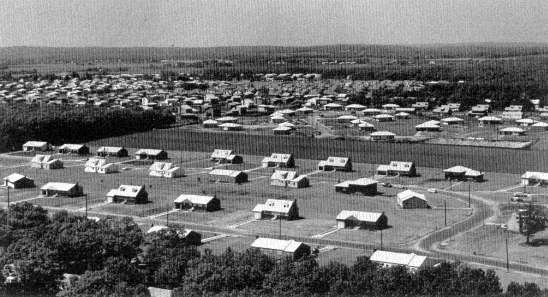
12. Hawthorne Boulevard, Artesia Boulevard, and San Diego Freeway, Los Angeles, 1961. Los Angeles traffic flows comparatively easily because its freeways were built to supplement an already generous network of wide streets, unlike the narrower street grids of older Eastern cities. Here, Hawthorne Boulevard, running north and south, shows maximum development of an automobile city street—six traffic lanes, median strip division, and one- and two-lane left-turn pockets. California Division of Highways, District VII
13. Long Island Single-Family Houses, 40 Miles from New York City, 1967. The automobile brought the Los Angeles growth pattern to the old New York metropolis, as elsewhere. Without voter authorization of new metropolitan subdivisions with green spaces, retailing organized, highways isolated from abutting houses, and homes appropriate to all classes, races, and ages, this highway and suburban pattern encompasses the metropolis in the same antisocial, environmentally destructive way as Los Angeles. Regional Plan Association, Louis B. Schlivek
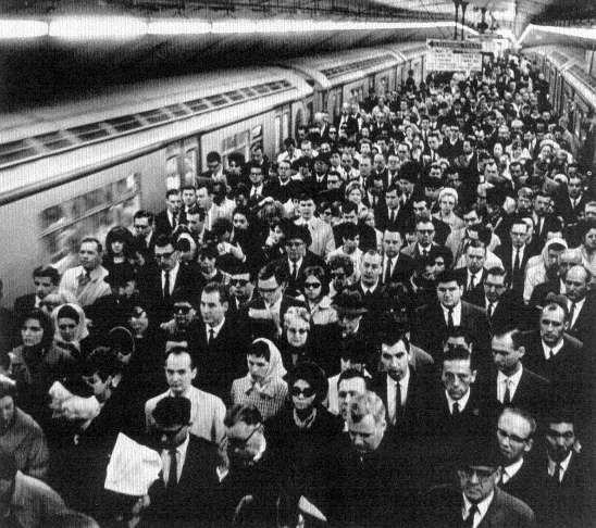
14. Grand Central Commuters, New York, 1969. There is no way to humanize the traffic caused by extreme population densities. Our experience shows only choices among evils. The most elaborate nineteenth-century designs demanded crowded trains, underground rides, dense pedestrian tides, even for wealthy suburban commuters. Regional Plan Association, Louis B. Schlivek
1.
Horsecar, New York City, ca. 1865
2.
Cable Cars, Chicago, ca. 1902
3.
Electric Streetcars, Chicago, 1906
4.
A Distant Streetcar Subdivision, Los Angeles, ca. 1890
5.
Downtown Traffic Jam, Chicago, ca. 1910
6.
Elevated Railway, Loop, Chicago, 1907
7.
Elevated Construction, Chicago, 1897
8.
Underneath the Elevated, Downtown Chicago, 1940
9.
Queens, New York, ca. 1920
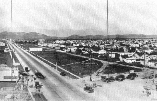
10.
Automobile Subdivision, East Los Angeles, 1930
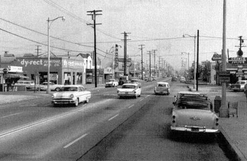
11.
Pico Rivera, Los Angeles, 1961
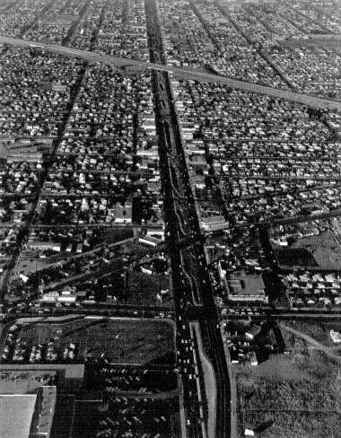
12.
Los Angeles, 1961
13.
Long Island Single-Family Houses, 1967
14.
Grand Central Commuters, New York, 1969
The systematic traffic research of the 1930s and its incorporation into the criteria for highway design governed the layout of the interstate highways that entered American cities in the late 1950s and 1960s. A succession of studies revealed the logic of highway traffic. In the twenties it was generally agreed that most of the traffic entering a city from outside its boundaries was passing through to destinations beyond it, an impression that nicely confirmed the wisdom of the contemporary policy of building roads between cities while more or less ignoring city congestion. Traffic engineers, however, began to station men at city intersections to ask motorists their origin and destination and learned that 80 percent of the traffic entering even a small city of twenty-five to fifty thousand inhabitants was bound for destinations within that city; for large cities the proportion rose to 90 to 95 percent.[37] Accordingly the city came to be recognized as a place of rising vehicular pressure, where the demand for driving room grew more intense as the streets approached the center. This perspective of course ran precisely counter to the availability of urban land, and it had somehow to be reconciled with the competing needs of stores, pedestrians, offices, and factories.
Further traffic counts, coupled with the discovery of reliable methods of sampling the population of a city to determine the routes most preferred, revealed the logic of intracity movement. In the central business districts, 50 to 60 percent of the entering vehicles were bound for destinations beyond the downtown core but were nevertheless forced to pass through it by the radial arrangement of the main arteries of most cities. Such information suggested that traffic jams could be eased and the demand for street space reduced if highways were planned as a belt around the downtown areas; no car then need enter the center if its destination lay elsewhere.[38]
Taken as a whole, the studies of the thirties suggested a new model for basic urban highway design—the pattern of the wheel. The downtown area would stand inside the hub, untouched by superhighways but surrounded by the new inner belt. As many radial highways as the size of the city required would be constructed like spokes from the inner-belt hub, two or three for a small city, five or six for a large one. Finally, at the outer edge of settlement, ready to accommodate the future growth of
[37] . U.S. Public Roads Administration, Highway Practice in the United States of America , Washington, 1949, pp. 53-55.
[38] . Public Roads Administration, Highway Practice , pp. 56-59.
Figure 1.
Atlanta Interstate Wheel
source: U.S. Geological Survey, The National Atlas of the
United States of America, Washington, 1970.
the city and to handle light intercity traffic, would be the outer-belt, or circumferential, highway.[39]
Just as traffic studies led highway engineers to the wheel model for
[39] . American Association of State Highway Officials, Committee on Planning and Design Policies, A Policy on Arterial Highways in Urban Areas , Washington, 1967, pp. 66-83.
urban roads, so studies of passenger-car speeds led them to the design specifications for the highways themselves. Tests at manufacturers' proving grounds showed the average top speed of low-priced American cars climbing rapidly. From forty-seven miles per hour in 1924 it rose to seventy-two by 1937 and 1938, and more expensive cars were capable of speeds of eighty or more. Further studies showed that the average motorist drove on the open highways at an average of forty-nine miles an hour, the overwhelming majority at less than sixty. Taking into consideration the trend toward faster cars as well as the fact that a highway represents so costly a capital investment that it should serve for twenty or more years, the engineers of the late 1930s concluded that superhighway speed limits should be set at fifty miles an hour in urban areas of heavy traffic and at seventy through open country.[40]
The decision on speed limits was the eventual determinant of the physical layout of the highway. It would have no intersections, and curves would be gentle enough to be negotiated at high speed. Traffic moving in opposite directions would be separated by median strips to prevent head-on collisions, and a breakdown lane or safety shoulder would lie at the outer edges of the lanes on each side. Lines of sight would be long and uninterrupted, and to this end grades would be moderate. Logical requirements indeed, but they were requirements that quite naturally led to the two- and three-hundred-foot right-of-way and to a wide-sweeping geometry that would inevitably conflict with the rectangular grid fabric of urban streets and buildings. Quite apart from the constraints of the topology of cities, which made the interstate highway a greedy competitor for space along the rivers and in the valleys, high speed limits made it an alarmingly disruptive force in city construction.[41]
Previously only the railroads had approached a geometry of such proportions, and their construction had preceded much American city growth; railroads had not been introduced into urban patterns already set, and subsequent city expansion could readily conform to their lines.
[40] . Public Roads Administration, Highway Practice , pp. 64-66.
[41] . The East River Drive in New York City, which dodges the amenities of its abutting neighborhoods, is a noteworthy exception to the usual insensitive practice of urban highway design. M. R. Werner, "A Reporter at Large: Through Thick and Thin," The New Yorker , 17 (April 5, 1941), 40-49; Joseph R. Passonneau, "Full Compensation and Transportation Corridor Analysis," American Society of Civil Engineers and American Society of Mechanical Engineers, Conference on Socio-Economic Impact of Urban Freeways and Rapid Transit Systems , Seattle, July 1971, pp. 5-6.
Nevertheless the railroads introduced an ominous precedent; peninsulas and islands of houses, factories, and warehouses were often isolated from the rest of the city by the tracks, so blighted by smoke and noise that the spaces were "lost." A survey showed that many old-time residents were not even aware of the location of these areas as the geometry of the tracks moved obliquely and indefinitely through the organization of city streets. Examples were Boston's South End and Chicago's southwest industrial districts, and indeed most cities had such railroad wastelands. Now a similar problem would be faced by more big cities and they would be dealing with mammoth transportation lines.[42]
Just before World War II, the studies made by traffic engineers in respect to the logic of the superhighway found mature expression in an analysis of a national system of turnpikes by the U.S. Bureau of Public Roads. This 1939 report, Toll Roads and Free Roads , compiled at the request of Congress, was the first of a series that led directly into the interstate highway program of 1956.[43] The pilot report set forth the design criteria for the restructuring of urban traffic and for the high-speed linkages of intercity movement. Also in 1939 the Futurama exhibit for General Motors at the New York World's Fair appeared and captured the public imagination as a model of the coming superhighways. Designed by the theatrical-set designer and city planner Norman Bel Geddes (1893-1958), this three-dimensional representation of a miniature countryside crisscrossed with effortless motoring impressed millions of Americans who stood in long lines for the chance to inspect it. Industry leaders and public officials pronounced the General Motors exhibit tremendous publicity for the sort of road experience that had greeted motorists only at the approaches to San Francisco's Golden Gate Bridge, on the Pennsylvania Turnpike, or on Connecticut's Merritt Parkway.[44]
World War II halted highway construction except for the building of roads to military bases and to new war plants. These strategic highways, though often hurriedly planned, did add to the nation's list of examples of limited-access superhighways, and they also broke the old formula for
[42] . Kevin Lynch, The Image of the City , Cambridge, 1960, pp. 22, 46-62.
[43] . U.S. Public Roads Administration, Toll Roads and Free Roads. House Document No. 272 , 76th Congress, 1st Session, Washington, 1939.
[44] . General Motors Corporation, "Dinner for American Association of State Highway Officials Given by Alfred P. Sloan, Jr., Chairman of General Motors Corporation, Terrace Club, New York World's Fair, Saturday Evening, October 14, 1939," Pamphlet, Transportation Library, University of Michigan.
matching federal-state funds for financing. They set the precedent for the 90 percent federal contribution that would become the final interstate financing formula.[45]
After the war, automobile registrations leapt forward to 41,086,000 in 1948 and climbed relentlessly year after year to 65,154,000 in 1956, the year in which the interstate bill finally passed Congress. Urban traffic jams lengthened, and in the densely settled corridors of the Northeast, Midwest, and West Coast, intercity traffic pile-ups occurred daily. It was found that in sections such as these, privately financed turnpikes could profitably be built. So substantial was the saving in time for the turnpike user that he willingly paid a toll for the privilege, just as travelers had on the toll roads of the late eighteenth and early nineteenth centuries. Maine, Massachusetts, Connecticut, New York, New Jersey, Ohio, and Illinois all authorized and built turnpikes in the 1950s, and their success increased the demand for a national network of superhighways. At the same time it became clear that the toll roads carried the most remunerative traffic and that they would scarcely serve to finance a full set of national roads. Nation-wide coverage required such diverse elements as the fabulously expensive urban inner-belt and radial roads, the lightly traveled linkages of the South and West, and the intercity ties to small cities throughout the nation. Finally, after rejecting several measures which were strongly pressed by President Eisenhower, state highway officials, and groups who used the highways or supplied the automotive industry, in 1956 Congress enacted a basic Federal Aid Highway Act.[46]
The 1956 act created the interstate system. Forty-one thousand miles of limited-access highways were to be built between 1956 and 1972, and these would link all the major cities and reorganize their internal traffic according to the hub-and-wheel analogue. An exception was made for the few cities already spread out into a number of centers instead of having a single downtown area; these were to receive highways in the form of a giant grid, not a modified wheel. Los Angeles is the most dramatic example of the grid alternative.[47] In any case the total effect of the interstate program, now nearing completion, has been
[45] . U.S. Bureau of Public Roads, Highway Needs of the National Defense. House Document No. 249 , 81st Congress, 1st Session, Washington, 1949.
[46] . AASHO, Story of the Achievements of the AASHO , pp. 181-97.
[47] . California Department of Public Works, Division of Highways, The California Freeway System. Report to the Joint Interim Committee on Highway Problems of the California Legislature in Conformity with Senate Concurrent Resolution No. 26 , Sacramento, September 1958.
to accelerate other existing tendencies toward the dispersion of the American city.
City planners, architects, sociologists, and urbanists of every sort have been debating the merits of decentralization for the past twenty-five years. Some of them argue that the loss of the dense single-centered city will be the end of our brand of civilization; others that low-density settlement will save us from the evils of urbanization. This is an important controversy, but to understand its relation to the American tradition of land management the governing factor is not centralization or decentralization but the ways in which the new roads were located. The highway program of 1956-72 could have been used to promote or to degrade new forms of centralization, but it was so radical an introduction into the urban land maps that it soon became certain that the highways would in fact create a new reticulation of their own. Regardless of whether or not we approve of the traffic relationships now emerging in every city, we can acknowledge that the interstate highways dramatized the complete failure of our land-management tradition in the face of the new challenge.
When highway engineers prepared to lay out the new urban roads, they confronted land regulations that were totally ineffective as guidelines for decisions at the metropolitan scale and equally ineffective for protecting the liberties of the city dwellers whose lives and homes would be disrupted by their work. Because city planning had been so closely tied to municipalities and their political boundaries, in 1956 no metropolitan planning agency existed for any American city. There were, to be sure, some consultative bodies—private ones such as the New York Regional Plan Association, and a few public agencies as in Atlanta, Cincinnati, Detroit, St. Louis, and Los Angeles—but no one of them had the requisite power to allocate metropolitan land for highway uses or for development by highway services.[48] Moreover, no rationale of metropolitan regional economics existed, and there was no popular consensus on what a metropolis ought to be or how it ought to function. Thus there was no way to calculate the costs and benefits of a metropolitan highway system or to set realistic goals for it. At a moment when city planning was most needed it had neither the knowledge, technique, procedures, nor power to guide the massive reworking of American urban land. There were not even any metropolitan transportation agencies to
[48] . Mel Scott, American City Planning Since 1890 , Berkeley, 1969, pp. 430-52.
Figure II.
Regional Interstates of Boston
SOURCE: U.S. Geological Survey, The National Atlas
of the United States of America, Washington, 1970.
coordinate highway planning with bus routes, rapid transit, rail commuting, or airport service. Indeed, so reluctant and ill-equipped were the cities to cooperate in planning that the Federal Aid Highway Act was amended in 1962 to the effect that after 1965, transportation planning agencies were to be created in all cities having more than fifty thousand population as a condition of state participation in the interstate highway program.[49] This meant that for the first decade of its operation the interstate program dealt with state highway departments familiar with intercity road construction but faced a multitude of metropolitan civil
[49] . Title 23, United States Code , Section 134; Scott, City Planning , pp. 580-85.
jurisdictions for intracity construction. Most cities were made up of ten, twenty, or even hundreds of separate zoning maps, each with a distinct land policy, for each borough, town, city, and incorporated and unincorporated settlement in the county or counties that huddled within the megalopolis. In practice, then, highway planners faced the choice either of following precedents by retracing the paths of the old state and U.S. routes which ran through the cities or of establishing new paths whose alignment would be determined by their own professional judgment. They did both.
The engineers did not consciously attempt to produce a new city form, although their work had such an effect, but sought only to use the conventional practices that had emerged in their past cooperation with state highway departments and adapt these to current patterns of urban land use. The intracity goal of the new interstate highways was to relieve congestion in the central business districts according to the strategy suggested by the research of the 1930s. The inner belt, the radials, and the circumferentials of the wheel pattern were to be so placed as to cause the least possible disruption to accepted land values rather than to lead each city toward a rational new solution to the automotive era.
In the American city of the 1950s and 1960s the accepted values were the inherited values of the private market in land, according to which commercial and industrial properties were the ones that sold for the highest prices and paid the largest taxes. Hence the old order of values ordered that these properties should be shored up in worth by new highways and not be seized for the two- to three-hundred-foot rights-of-way needed to insert superhighways into existing blocks. Moreover, the areas that were least developed and often had no commercial value at all—open spaces, parks, river margins, and undeveloped farmland and woodland became prime locations for the new roads. The fact that such land had indeed high public value as open space or as beauty spots of the city had no relevance for the engineers. In rejecting such use and value they were responding only to the pricing system of the private land market.[50] Even today, after the devastation of many urban open spaces and after fifteen years of research into highway economics, there is no accepted criterion for assessing the worth of parks, views, and land of low market value in the calculation of the costs and benefits accruing from differing highway locations.
[50] . AASHO, Arterial Highways in Urban Areas , pp. 89-91.
Thus the wheel design for urban interstate highways was the product of purely commercial values. Its first duty was seen as the alleviation of traffic pressure on the central business districts; its next to assist, by means of radial and circumferential roads, the existing shopping centers and industrial parks and to encourage the development of new ones. It was this shortsighted objective of causing the least disruption to established commercial values of the private land market that made the metropolitan zoning maps the instruments of planning. The zoning districts, which after all represented only the building uniformities of the past, became the principal determinants of the form of the new automotive megalopolis.
Interstate engineers also inherited the confusions and inadequacies of the public housing program and the inequalities of compensation law. Successive campaigns of city building had laid down concentric rings of houses in which the oldest homes naturally lay closest to the original site of the city. As time passed and the cities grew, downtown areas came to be surrounded by a thickening band of the homes of the white and black poor. The poor concentrated even more in these districts after World War II because rents were lowest there and public transportation to work most abundant. These areas were popularly denigrated by being classified as slums and legally defined as "blighted areas," with no discrimination as to the condition of individual houses or consideration of the social functions of poor neighborhoods. In these districts New Deal public housing began its clearance work, tearing down the "blight" and replacing it with new housing projects. Working in a climate of many vacancies and empty crumbling houses, the small-scale projects of the thirties and early forties ignored the effects that the razing of slums would have upon the social structure of the neighborhoods of the poor. They could afford to do so because at most they disturbed a few blocks. Nevertheless these were the projects that thenceforth stigmatized these areas, both by publicity and law, as blighted and fit only for destruction.
By an unhappy convergence of history, the interstate highway program passed Congress in an era of political reaction, so that the seizure of poor urban neighborhoods coincided with a cutback in public housing. Since the location of roads just outside the urban center was implicit in the wheel strategy of the highway engineer, the cry of "blight" urged on him the merits of taking as much of the land of the poor as he wished. Thus to rip out the houses of the poor was a transportation principle that became a public contribution rather than an act
of social irresponsibility. It might have been expected that a rational and humane society would confront the repercussions of highway building on the metropolitan scale by the erection of enough public housing to compensate for the units plowed under by the highways and to place these units so that the new transportation routes could conveniently be used for job access. Instead such American housing as still went forward was confined to the political boundaries of each zoning unit. Center-city projects remained in the center city; they could not, as in London, be used to relocate the poor to give them the benefit of the new roads in reaching their new work areas. Because of the convergence, then, of the political mood, the transportation explosion, and the traditional fragmented American city, poor neighborhoods came to bear a disproportionate share of the costs and suffering that attended the reconstruction of the metropolis.
In short, the land needs of the highways were so enormous as to upset the urban housing market to the strong disadvantage of the poor. A 1968 study of Baltimore reveals how relentlessly highway construction costs there bore down upon the poor of the central city. The old core city lacked vacant land or new residential building, yet it was the principal—and indeed for blacks the only—area where low-income families could find decent housing within their price range. At the same time, racial pressures were driving an increasing number of blacks back to the central city from the suburbs, and no public housing programs were planned for the city or region to relieve the shortage of shelter. On the contrary, in ten years' time, from 1965 to 1974, Baltimore was scheduled to lose 10 percent of its existing housing to public works, equivalent to the loss from a siege or repeated bombing attacks. The prognostication therefore was for rising rents but no improvement in housing conditions.[51]
The Baltimore Urban Design Concept Team was able to loosen the vise to some extent by moving the proposed inner-belt highways a mile farther from the downtown district than had originally been planned.[52] No justice could be done, however, in respect to the poor, black or white, since neither the Department of Transportation nor the Department of Housing and Urban Development was prepared to undertake new housing projects or to compensate displaced families for the real
[51] . Charles Abrams, The Role and Responsibilities of the Federal Highway System in Baltimore , Baltimore, 1968, pp. 3, 8.
[52] . Passonneau, "Full Compensation," p. 12.
costs of their removal. There is some evidence from the Baltimore study and others like it that in many cities the inner-belt highways have been placed too close to their centers for traffic efficiency simply because the costs of recompensing displaced families have not been fully paid.[53] In these cases the cost estimates for land and structure takings are falsely low because the compensatory payments as specified do not include all the damage suffered by tenants, small businesses, land-contract home buyers, and owner-occupiers of substandard homes.
The specific provisions of land condemnation when considered as a whole have meant that much of the cost of urban highways has been pushed off on those who live in their path. The long period that elapses between the first rumors of the road location and the final taking of the land inevitably depresses the market value of such informally earmarked property. Sales dwindle to a trickle, public services decline, businesses leave as their leases expire, vandals attack unused buildings. In short, the neighborhood deteriorates rapidly and with it the values upon which compensation will ultimately be measured. Those who, unlike conventional-mortgage home buyers, are trying to purchase homes on a land contract—a popular method in poor neighborhoods whereby sellers retain the property title as security until the full price is paid—can lose their homes without any compensation at all. For a number of years tenants, the most numerous group of the poor, were made to vacate their premises without aid or compensation since they legally held no private property. Small businessmen did receive aid for moving expenses, but common law specifically exempted compensation for good will, even though the reputation of a business might constitute its very raison d'être . A 1962 amendment to the federal statute tried to alleviate this inequality by calling for states to institute relocation programs for those displaced by interstate highways, but the lack of effective coordination among social agencies which could deal with the social problems of displaced families, the low moving allocations, and the shortage of decent housing at comparable rents or prices crippled this benign goal. Finally in 1968 Congress passed a law allowing additional compensation of up to $5,000 for homeowners to help them buy new houses, and grants for two years of up to $1,500 to tenants to help them pay higher rents, but such aid could not guarantee a new home in a nearby neighborhood or make any headway against the urban low-income
[53] . Ibid., p. 13.
housing shortage.[54] Moreover, public-interest lawyers have charged that in the rush to initiate projects callous local authorities have ignored many of these protective measures and that the federal government has not enforced its own rules.[55]
The individual and class injustices that have marked land practices relating to the interstate highways since their inception in 1956 were an inevitable consequence of the violent disparity between the metropolitan scale of the highways and the parcel-by-parcel justice of the old law. For the well-to-do, a good lawyer and the wide choice of other homes makes relocation a comparatively harmless matter. For the poor, in whose neighborhoods highways were located with the precise aim of minimizing the disruption of high-value property, both the traditions of the property law and the workings of the free-enterprise housing market meant suffering without adequate redress. As angry citizens discovered in meeting after meeting, no mechanism in which their interests could receive adequate weight controlled highway siting. The law and the political structure of the metropolis could create city councils, condemnation hearings, and courts in which the individual or neighborhood might be heard, but at no point was the neighborhood powerful enough to achieve its goals in the face of the gigantic highway program. Occasionally an informal league of neighborhoods could arouse public anger to such a pitch that a highway would be halted, as happened in San Francisco and in Cambridge, Massachusetts, but such victories only underlined the irrationality of the whole procedure.[56]
The huge scale of the interstate highways requires national and multistate planning decisions that should be made on the basis of national goals for full employment, regional economic growth and land development, and human-resource potentials. So far no democratic method of planning appropriate to such decisions has appeared at the national, state, or metropolitan level. We have seen that city planning never developed such procedures, and when in 1965 metropolitan planning became a compulsory adjunct to highway design, no other agencies or rules for adjudicating the opposing economic and land-development
[54] . Anthony Downs, Urban Problems and Prospects , Chicago, 1970, pp. 192-227; Wallace F. Smith, "The Relocation Dilemma," The Appraisal Journal , 37 (July 1969), 424-32.
[55] . Edgar S. Cahn et al., The Legal Lawbreakers, A Study of the Nonadministration of Federal Relocation Requirements , Citizens Advocate Center, Washington, 1970.
[56] . Gordon Fellman and Barbara Brandt, "Working-Class Protest Against an Urban Highway," Environment and Behavior , 3 (March 1971), 61-79.
interests were forthcoming. Instead power was handed over to administrative bodies of mixed government and business interests. Perhaps it is not surprising that no democratic planning procedures for dealing with the highways had emerged in a society that has clung for three hundred and fifty years to the concept that government was supposed to aid private property and not to allocate land for the general benefit of society.
As the late Charles Abrams has so ably pointed out, dealing fairly with the displaced and the adjoining neighborhoods could have been an easy task, well within the capabilities of our society, since such action lay within the reach of conventional city planning. Both the Department of Transportation and the Department of Housing and Urban Development have sufficient authority to build housing that will relieve the shortages caused by urban-renewal and highway projects. Legal precedents for the joining of housing to other public works abound in the war workers' housing of World Wars I and II, and whole towns have even been built as in the instances of Greenbelt, Maryland, Oak Ridge, Tennessee, and much of Cape Kennedy. Instead Congressional antipathy toward the urban poor has joined with administrative callousness to aggravate housing shortages. Highway programs, by taking responsibility for an entire project instead of for isolated parts of it, could have included the needs of neighborhoods adjoining the highway alignments. It would have been necessary only to move the boundary of responsibility beyond the planting and the chain-link fence into the affected areas.[57]
The raising of such neighborhoods to modern urban standards—in most cases at present they conform only to the standards of 1900—is a legitimate function of highway construction and a proper use of Highway Trust Funds; neglect of this function has meant that adjacent homes have been forced to pay the costs of the benefits enjoyed by motorists. The standards for a decent neighborhood in regard to noise, air, traffic, public and commercial services, and housing are well established. Such specifications lie in the dusty files of every local city planning office, in the desks of city inspectors and engineers. These norms, so well documented and widely agreed upon, could serve as the basis for a democratic planning process, and abutting neighborhoods could deal with issues on which they have knowledge and competence, and over which they have appropriate jurisdiction. In disputes between neighborhoods and planning officials the standards could serve to decide civil suits.
[57] . Abrams, Role and Responsibilities , pp. 13-22.
Furthermore, such documentation and its relative uniformity would enable courts to act with dispatch without having to assume the impossible task of balancing the equities between an aggrieved landowner and the logic of a metropolitan highway.[58]
Because such opportunities have never been realized, local groups have served only in an obstructive role. They have never been able to insist that the building of a highway, which after all involves the rebuilding of a city, include neighborhood reconstruction. Both city and neighborhoods have suffered. From the city's point of view, the outworn values of the private land market and the outmoded traditions of seventeenth-century land law have fixed its form for a long time to come.
Long lines of disparate historical trends, including private land speculation, attempts at regulation, private controls over public building, and the Balkanization of metropolitan political units, all came together after World War II to create in American cities the worst of all possible worlds. The freedom of the individual, which had been the dominant concern of our land-law tradition, disappeared with the growing scope of the influence of all manner of highway, urban renewal, and housing officials.[59] At the same time, the benefits of mass housing and of rational urban investment, both inherent in European socialism, were rejected by an unshakable commitment to the private land market.
[58] . Frank I. Michaelman, "Property, Utility, and Fairness: Comments on the Ethical Foundations of 'Just Compensation' Law," Harvard Law Review , 80 (April 1967), 1171, 1193-95, 1224-26, 1248-58.
[59] . Allison Dunham, "Property, City Planning, and Liberty," and David W. Craig, "Regulation and Purchase: Two Governmental Ways to Attain Planned Land Use," in Charles M. Haar, ed., Law and Land, Anglo-American Planning Practice , Cambridge, 1964, pp. 28-43, 181-211.