Identifying Buguias in the Ethnographic Landscape
The indigenous inhabitants of the Cordillera, collectively referred to as Igorots (a term some groups find offensive), were never hispanicized, and they retain a limited cultural autonomy to this day.

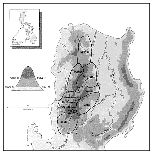
Map 2.
The Standard Ethnographic Map of the Cordillera of Northern Luzon.
Western ethnographers have divided these highland peoples into seven or eight major groupings, once considered tribes, now usually termed ethnolinguistic groups (LeBar 1975, Keesing 1962; see map 2). But the categories employed here reflect a convoluted history of academic misconceptions (for an indigenous scholar's as-
sessment of the standard ethnographic classification, see Magannon 1988).
In the nineteenth century, Spanish and German observers partitioned the Cordillera by entirely different schemes; these may have been less accurate but they were no more misconceived than those later perpetrated by the Americans. The American ethnographic map originated with the outrageously sloppy scholarship of Dean C. Worcester, self-styled white deity of the archipelago's non-Christians (see Hutterer 1978). Finding the Spanish and German classifications cumbersome, Worcester (1906) took it upon himself to define new groups among the highlanders. Unfortunately, he seriously misunderstood the foreign-language sources he was criticizing.[2] In classifying the various Cordilleran peoples, Worcester ultimately relied on visually distinctive cultural features casually observed by himself and his friends.[3]
Competent ethnographers later modified Worcester's system. In Benguet, Moss (1920a , 1920b ) successfully insisted that the linguistic groups called Kankana-ey (or Kankanay) and Nabaloi (or Ibaloi), long recognized by all able observers, deserved separate "tribal" status. But Worcester's overall scheme prevailed, distorting subsequent ethnographic perceptions. Some of his so-called tribes, such as the Kalinga, were but melanges of dissimilar cultural groups (some of which have since coalesced to a degree); other more coherent groupings, most notably the Kalanguya (or Kallahan), received no recognition at all, simply because neither Worcester nor any colonial anthropologist happened to visit them.[4] Recently linguists have begun to devise a more accurate classification system, but many geographic subtleties continue to elude cultural taxonomists (see, for example, Wurm and Hattori 1983; for the best work on southern Cordilleran linguistic and cultural groupings, see Afable 1989).
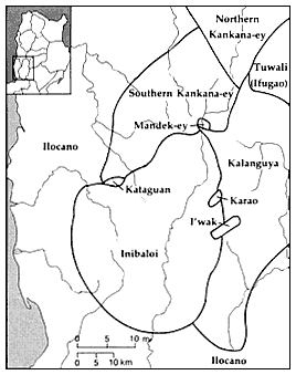
The case of Buguias reveals the inadequacies of the standard classificatory scheme. The community lies in the interstice of three linguistic or cultural groups; two of these, the Ibaloi and the Southern Kankana-ey, are now recognized, but the third, the Kalanguya (or Kallahan), remains virtually ethnographically invisible (see map 3). Although Buguias was probably an Ibaloi settlement originally, its residents today are most closely related (genealogically) to

Map 3.
The Languages and Dialects of the Southern Cordillera.
Mandek-ey, or I-Buguias, is at present spoken only
in the southernmost hamlets of Buguias Village.
the Kalanguya; the village dialect (called Mandek-ey, or I-Buguias), while containing elements of all three neighboring tongues, is also most closely affiliated with Kalanguya. Over the past sixty years, however, Kankana-ey has penetrated southward into the village, and today Mandek-ey survives only in the southernmost hamlets of Buguias. As a result, outsiders generally classify Buguias as a Southern Kankana-ey community.
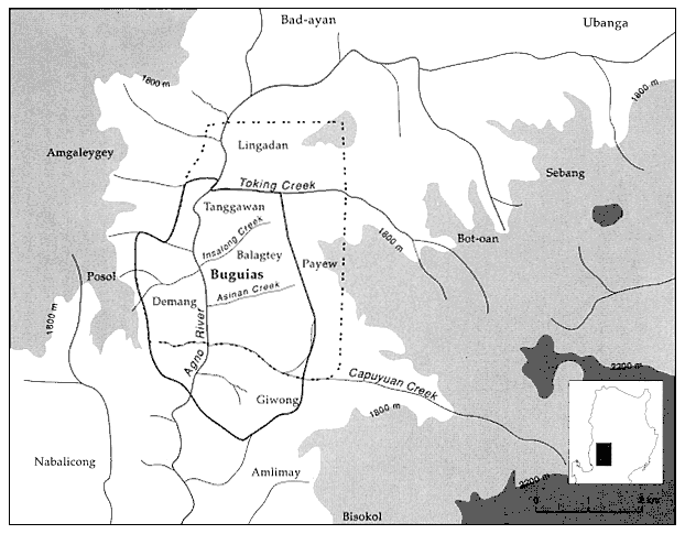
The geographic referent of the term "Buguias" is also equivocal. It originally referred to a single territorially based village, in some respects an indigenous microstate. Like other sizable Cordilleran villages, Buguias was accorded a vague political status under the Spanish colonial regime; gradually this solidified, and today Buguias forms a barangay , the smallest political territory in the Philippines. The modern barangay, called Buguias Central, corresponds

Map 4.
Buguias Village. The dashed line encloses the modern barangay of Buguias Central; the solid line encloses the
traditional village, or ili , of Buguias. The traditional village was divided into four constituent units (Tanggawan,
Balagtey, Giwong, and Demang) during the American period. These smaller ili function today
imperfectly to the old village, since over the years some hamlets have been grafted to the original community while others have been deleted from it (see map 4). Only in the ritual realm does the old communal structure survive, and even here it was significantly transformed when the village elders, sometime in the American era, split the old village into four constituent sacerdotal units.
But "Buguias" also refers to an area larger than the barangay, or village, of that name. The southern Cordilleran peoples have long classified their neighbors according to several partly overlapping ethnographic systems, based respectively on language, environment, and proximity to large, older settlements. Since Buguias has long been an important community, its name is applied to a region extending well beyond the boundaries of the village itself. To their Cordilleran neighbors, "the Buguias people" includes not only the inhabitants of Buguias village but also the residents of surrounding communities—individuals who would identify themselves as being from Buguias when visiting distant places.
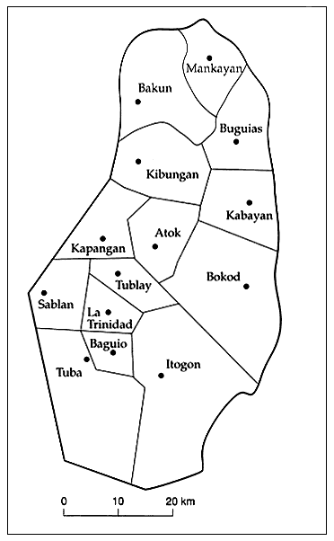
Roughly corresponding to this region is Buguias municipality in the imposed political hierarchy (see map 5). Both the Spanish and the American colonialists administered sections of the southern Cordillera through the larger villages, first designated rancherias , later townships, then municipal districts, and finally municipalities. Since the Americans continually sought to economize by consolidating these units, municipal boundaries remained unstable. Early in the century, for example, "greater" Buguias annexed its northern neighbor, Lo-o. Even under the postcolonial Philippine regime, Cordilleran municipal boundaries have shifted as municipalities have vied for several tax-rich border zones. At the same time, villages within the same municipality have sometimes contended for the seat of local government, further reworking geographical alignments. Buguias municipality, in fact, has for some years been administered not from Buguias Central but from the more accessible crossroads community of Abatan.
In this work, "Buguias" will refer both to the indigenous ritual village (now divided into four units) and to the modern barangay. Although the boundaries of these two divisions are not exactly coincident, ambiguity is minimal. When the larger regional unit is intended, it will be designated either as Buguias municipality or as greater Buguias.

Map 5.
The Municipalities of Benguet Province. (Refer to map 1 for relative
location.) The city of Baguio forms an enclave, independent from the
surrounding province.