Composite Cone Geothermal Systems
As discussed earlier in this chapter, many of the geothermal systems that were believed to be part of composite cones are actually located below the mature cones or are linked to other structures such as calderas and recent extensional faulting. Within the
Cascade Range of the U.S., there are few surface manifestations of hydrothermal activity at young composite cones (Duffield, 1983). Basaltic and andesitic volcanoes are generally not underlain by large, shallow crustal magma reservoirs. Only the most mature of these cones contain known geothermal reservoirs: for example, Crater Lake and Newberry volcanoes in Oregon, where there are young, voluminous, silicic magmas and small calderas.
For many composite cones, the traditional exploration methods such as measuring shallow heat flow, examining surface manifestations (hot springs, fumaroles, acid alteration, etc.), and evaluating electrical geophysical data are not successful (LaFleur, 1983; Wright and Ward, 1983). In most cases, high infiltration rates for rainfall and snowmelt near volcano summits can hydrologically mask any geothermal systems because the summit and slopes are saturated with cold water to depths of 500 m to 1 km. Within the Cascade Range of the western U.S., this phenomenon is known as the "rain curtain" (Swanberg et al ., 1988). Groundwater heated by plutons below Quaternary-age volcanoes of the Oregon Cascades flows laterally into the upper zones of older volcanic rocks on the flanks of the volcanic chain. The result is an area of near-zero shallow conductive heat flow around the young volcano as well as shallow high thermal gradients in the older rocks (Ingebritsen et al ., 1989). In this environment, the only effective exploration/evaluation methods are (a) a search for indirect clues such as youthful silicic tuffs and lavas and phreatic craters, (b) the qualitative maturity index (Fig. 7.6), and (c) intermediate to deep thermal gradient holes.
Proven (Drilled) Geothermal Fields
Meager Mountain
Meager Mountain in British Columbia, Canada, with a volume of 70 km3 and a cone height of 1500 m, comprises nine overlapping andesitic and dacitic volcanic assemblages that range from late Pliocene to 2440 years BP (Souther, 1985). Its multiple vents are aligned along a north-south trend. The volcano overlies a high-relief surface of older plutonic and metamorphic rocks (late Mesozoic to early Tertiary Coast Plutonic complex and late Miocene epizonal plutons). The older rocks consist of andesitic flows and volcanic breccias, and the younger rocks are dacitic flows and domes, ashfall deposits, and ignimbrites.
Warm springs of ~60°C issue from faults within the basement rocks at the base of the volcano. Much of the anomaly is masked by near-surface meteoritic water. Fifteen
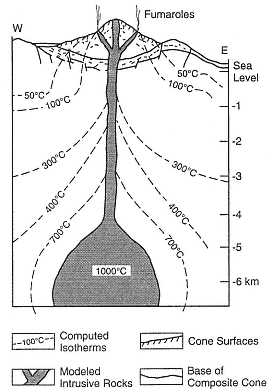
Fig. 7.20
This computed temperature profile of
Hakone volcano in Japan was created for a
composite cone located within a small caldera.
(Adapted from Iriyama and Oki, 1978.)
coreholes were drilled on the northern and southern flanks of the volcano (Adams et al ., 1985). Argillic alteration of the basement rocks was detected on the northern slope, but no hydrothermal fluids were found. Below the southern slopes, a plume of hot water (~200°C) rises along north-south-trending faults and along fractures within basement rocks; 233 to 264°C fluids were encountered at depths of 3 to 3.5 km in fractured plutonic rocks.
The hydrothermal resource is fracture-dominated and follows the Meager Creek fault zone, where the host rocks have low permeability and porosity. It is likely that the fluids are heated by subvolcanic intrusive rocks, but the amount of thermal energy contributed by cooling dikes and plugs is not known. The system may be related to deep circulation of fluids along the Meager Creek fault zone. Souther (1985) reported on two drilled reservoirs; the shallow, low-temperature (<140°C) reservoir has been clogged with authigenic minerals and forms a barrier for deeper, hotter fluids; the deeper reservoir, in fractured basement rocks, has temperatures >200°C.
Momotombo
The Nicaraguan Depression in Central America, which lies parallel to a northwest-southeast-trending plate boundary, encompasses most of the Quaternary-to-historical volcanic fields of Nicaragua. Momotombo Volcano, located on the northwestern shore of Lago de Managua, is a 1258-m-high symmetrical cone, with a volume of 12 km3 (Fig. 7.21 and cover photo). Momotombo is a submature composite cone within a northwest-southeast-trending graben and adjacent to a 4-km-diameter caldera. The somma ridge of an undated but older cone is located ~900 m above the base of Momotombo. The youngest rocks here are andesitic lavas that were erupted in 1905 AD (Mooser et al ., 1958).
Surface geothermal manifestations include active fumaroles in the summit crater and hydrothermally altered ground over a 4 km2 area along the southern slope of the volcano. This altered ground follows hydrothermally active, northwest-trending fractures (Figs. 7.21 and 7.22). Drillholes up to several kilometers deep were sited in interbedded andesitic lavas, welded tuffs and ashes, basaltic lavas and ashes, and dacitic lava; the most common rock type is andesitic lithic tuff (Moore et al ., 1982). Some of the rocks have been interpreted as phreatomagmatic—which is certainly possible because Momotombo sits on the shore of Lake Managua.
Maps of the alteration aureoles suggest structural control and fracture permeability within the reservoir and have provided an excellent basis for siting both exploration and production drillholes. Most of the wells with high permeability are within 100 m of a high-angle reverse fault and a right-lateral strike-slip fault. Some of the fractures show signs of secondary brecciation and may have formed by hydraulic fracturing (Moore et al ., 1982). Drilling has determined that there is good correspondence between surface and subsurface structure. The highest temperatures (225°C) are within a lens-shaped reservoir at depths of 244 to 366 m. In 1979, six production wells supported a 30-MWe plant; Rowley (1982) estimated field capacity is 800 MWe , although that is an optimistic estimate.
Ahuachapán
The Ahuachapán geothermal field in El Salvador Central America is associated with the Laguna Verde volcanic complex, which consists of north-northeast-trending lines of craters and small cones. The 500- to 600-m-diameter craters at the summit of these composite cones may be phreatomagmatic. These volcanoes are composed of interbedded andesitic tuffs, lavas, and agglomerates that range from Pliocene to Holocene (a very general estimate by Romagnoli et al ., 1976).
Also associated with the Laguna Verde volcanic complex and north-northwest-trending
normal faults are two major hot spring areas and three fumarolic fields with temperatures as high as 123°C. The geothermal wells located in this area are producing fluids from interbedded pyroclastic rocks and lavas with temperatures of 228°C at a depth of 900 m. Production wells have been drilled to average depths of ~800 m. The fumaroles, hot springs, and most of the drillholes are located near intersections between north-northwest-trending faults and east-northeast-trending faults. Two 30-MWe - and one 35-MWe -capacity electrical generating plants were completed by 1987.
Ohnuma
The Ohnuma geothermal field of Japan is located on the flank of Hachimantai Volcano, an 800-m-high, flat-topped lava shield composed of mafic andesitic lava flows (Kuno, 1962). This immature composite cone, where lavas range from 0.5 to 1.0 Ma, has a volume of ~13 km3 .
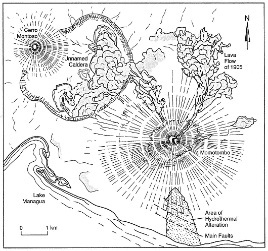
Fig. 7.21
Map of Momotombo Volcano in Nicaragua shows the main faults and
areas of alteration, which are marked with a stippled pattern.
(Adapted from Mooser et al ., 1958; Moore et al ., 1982.)
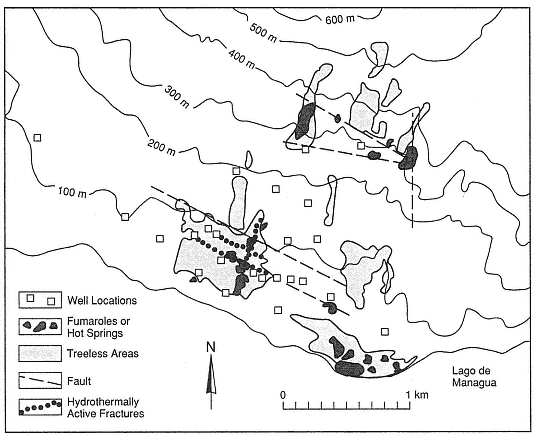
Fig. 7.22
The Momotombo geothermal field is located on the southern slopes of
Momotombo volcano and on the edge of Lake Managua.
(Adapted from Moore et al., 1982.)
Thermal areas marked by geysers, mudpots, fumaroles, and hot springs cover 5 km2 . The hydrothermal system may not be directly related to the composite cone, but rather to an older caldera and a north-south-trending graben. The reservoir is located within highly fractured dacitic and andesitic lavas and interbedded pyroclastic rocks (Nakamura et al ., 1981; Kimbara, 1986). Production wells have been drilled to depths of 1.3 to 1.7 km.
Matsukawa
The Matsukawa geothermal area of Japan is located between the Maru Mori and Iwate volcanoes. The area's largest cone is 800 m high and the volcanic complex has an approximate volume of 45 km3 . This complex includes composite cones, a dome, and a 1.8- by 3.0-km-diameter summit caldera. Kuno (1962) reported that its lava flows and volcanic breccias consist of augite-hypersthene andesite (in the older part of the cone) and olivine andesite (in the main cone). The summit crater contains fumaroles and small areas of acid alteration. This complex is believed to be of Pleistocene and Holocene age.
The geothermal area is marked by a 0.5- to 1- by 7.0-km east-northeast-trending zone of argillization, silicification, and hot springs. The zone overlies a geothermal reservoir at a depth of 1.0 to 1.2 km in fractured welded tuff and shale; there is a caprock of welded tuff (Nakamura et al ., 1981; Kimbara, 1986).
Because the geothermal system is located on the rim of a caldera, it may be only partly related to the cone.
Tamagawa Spa
The Tamagawa Spa of Japan is a group of acidic hot springs located at the western foot of Mount Yake (Yakeyama). Mount Yake is a 750-m-high mature composite cone with a volume of 10 km3 (Kuno, 1962); the cone's 600-m-diameter summit crater contains a small dome and four small explosion craters. There is also a parasitic dome on the southern flank of the main cone. Mount Yake is composed of mostly hypersthene-olivine andesitic lava flows and pyroclastic rocks, and the domes are andesitic. The most recent eruption products are Holocene. This cone may overlie the rim of an older caldera and the hydrothermal system could be associated with that caldera.
The geothermal area (spa) comprises lines of fumaroles, hot springs, and deposits of silica sinter, all of which are oriented east-west and north-south. The springs have temperatures up to 98°C and pHs of <1.2. The main geothermal area is located in a depression that has been interpreted as both a phreatic crater and a landslide. The reservoir is located within fractured Tertiary-age tuff, shale, and andesitic lava (Nakamura et al ., 1981).
Bouillante
The volcanoes of Guadeloupe, in the Lesser Antilles, include composite cones and domes and are located along the north-south-trending spine of Basse-Terre (the high, volcanic portion of the island). Soufrière de Guadeloupe is a dacitic dome with a summit 1467 m above sea level and is the site of historic eruptions that included explosive phreatic activity 1976 to 1977 AD. Eruptions of Soufrière de Guadeloupe have produced phreatic deposits, pyroclastic fall deposits, ignimbrites (mostly nonwelded), andesitic lavas, laharic breccias, and dacite domes. Vatin-Perignon et al . (1984) documented ages from 0.3 Ma to the present.
The summit region of Soufrière, site of the youngest cones and domes, is cut by northwest- and northeast-trending faults, along which there are surface manifestations of the geothermal system such as summit fumaroles and large areas of acid alteration. Hot springs are located around the base of the most recent dacite dome, which was recently modified by phreatic eruptions (Heiken et al ., 1980).
A commercially developed hydrothermal system is located on the island's west coast along a northwest-trending fault and a line of small cones that extends from Soufrière de Guadeloupe down to the coastline (Fig. 7.23). At Bouillante, there are areas of hydrothermal alteration and silicification as well as a 98°C spring. The geothermal reservoir, located within Tertiary tuffs and andesitic lava flows, has both fault (fracture) and formation permeability. Temperatures at a depth of 500 m are >240°C (Demians et al ., 1972; Vatin-Perignon et al ., 1984). Epidote appears in rocks below 100 to 300 m.
Kawah Kamodjang
The fumarole field of Kawah Kamodjang in Indonesia is located in western Java, where its specific association with a composite cone or cones is not clear. The nearby volcanoes of Rakutak, Chihara, Danou, Pangkaban, Gandapura, Masagit, and Guntur are part of a 15-km-long, 4- to 5-km-wide volcanic chain, which is parallel to a graben that trends west-southwest and east-northeast; most faults strike N60°E. The highest cones have elevations of ~1500 m and are composed of well-bedded, massive pyroclastic rocks that are interbedded with thick andesitic flows (Neuman van Padang, 1951; Robert et al ., 1983). Robert et al . (1983) postulated that the geothermal area may be located within a small (2-km-diameter, 500-m-deep), poorly defined caldera.
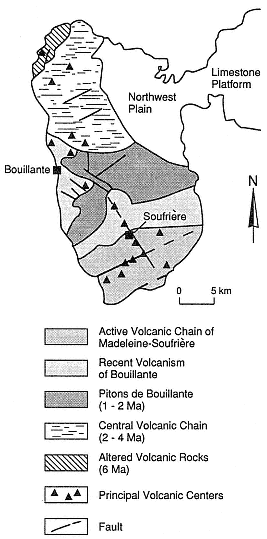
Fig. 7.23
Sketch geologic map of the western part of the
island of Guadeloupe (Basse-Terre) in the
Lesser Antilles. The Bouillante geothermal
area is located along northwest-trending
faults that extend downslope from the active
volcanic chain of Madeleine-Soufrière.
(Adapted from Gérard et al. 1981.)
Within the 2-km-wide depression is a 1200-m-long, 100- to 700-m-wide zone of fumaroles, mudpots, phreatic craters, and hot springs with temperatures of 80 to 105°C. Six production wells supplying a 30-MWe generator were drilled in small grabens within the larger graben. The drilled reservoir is located within hydrothermally altered, fractured tuffs and lavas, where temperatures reach 200 to 230°C, at a depth of 900 m (Robert et al ., 1983). The main caprocks are hydrothermally altered pyroclastic deposits.
Composite Cones with Possible Geothermal Potential—As Yet Unproven by Deep Drilling
Mount Shasta
Mount Shasta, one of the southernmost of the Cascade volcanoes, is located in northern California. With a volume of 350 km3 and an elevation of 3050 m, this mature composite cone is also the largest Cascade volcano. The summit crater, two older central vents, and a line of flank vents are located along north-south trends (Christiansen et al ., 1977). Large dacitic cones and flows have erupted from both summit and flank vents. A 450-km2 area northwest of the volcano is covered by a hummocky debris avalanche deposit, which Crandell et al . (1984) interpreted as a sector collapse of the main cone ~300,000 years BP.
The cone is made up of equal portions of lava flows and blocky pyroclastic debris, including pyroclastic flow deposits and volcanic mudflows (Christiansen et al ., 1977), most of which are composed of pyroxene-andesite and hornblende-bearing andesite. Basalt is found only below an altitude of 2100 m in cinder cones and small lava flows. Mount Shasta formed during the last 500,000 years, and four periods of cone-building activity have occurred during the last 250,000 years (Christiansen, 1985).
There are summit fumaroles and areas of intense local hydrothermal alteration on each of Mount Shasta's four main cones, but nowhere else. Theoretically, there should be a small hydrothermal system within or below this large composite cone; however, there is no evidence for such a system because of the effective shield established by high flux of cold water from rain and
snow on the mountain. To date, there has been no drilling on Mount Shasta to test for a geothermal system.
Mount Hood
Mount Hood, also in Oregon, is located within a broad graben that follows the summit of the north-south-trending topographic high, which is the backbone of the high Cascades of the Pacific Northwest. Mount Hood was an obvious target for geothermal exploration and research, and a cooperative effort was begun in 1976 by a consortium of federal and state agencies (Williams et al ., 1982).
Mount Hood is a 2200-m-high mature composite cone with an approximate volume of 188 km3 . Eruptions have occurred there over the past 700,000 years; the most recent was less than 200 years ago (Wise, 1969; Crandell and Meyer, 1977). Mount Hood is composed of interbedded thin lava flows and pyroclastic debris (ashfall deposits, ignimbrites, and laharic breccias). Little is known or has been inferred about intrusive rocks in Mount Hood (shown in cross section in Fig. 7.24) except for the "plug" dome that comprises andesitic and hornblende andesitic lava; peripheral cones are composed of basalt.
The only surface manifestations of a hydrothermal system on Mount Hood are summit fumaroles, at temperatures of 50 to 85°C, and areas of hydrothermal alteration surrounding the plug dome. Although 25 shallow wells have been drilled on the flanks of Mount Hood, no shallow magma chamber or large hydrothermal systems were detected; the shallow wells did not penetrate the near-surface outflow zone of cold groundwater.
The deepest geothermal gradient hole drilled at Mount Hood is located on the lower flanks of the volcano near faults in basalt flows that predate Mount Hood; the bottomhole temperature of this well is 120°C at a depth of 1.8 km (Priest, 1982). The thermal gradient of ~60°C/km in this corehole could be related to magmas in the cone, but it also can be explained solely by the high heat flow in this tectonically active area.
Because of the enormous terrain corrections required for analysis, and the presence of a cold groundwater shield below the slopes of Mount Hood, most traditional geophysical
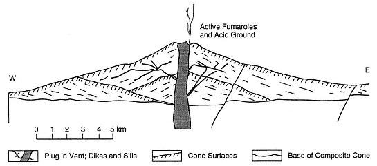
Fig. 7.24
Composite cross section of Mount Hood in Oregon.
(Based on work by Wise, 1968; Williams et al. , 1982; Priest, 1982.)
exploration methods did not reveal the presence or absence of a hydrothermal system. Shallow drilling penetrated some zones of warm water, but most drillholes never reached beyond the cold, near-surface groundwater. There may be a hydrothermal system below this large, young composite cone, but it has not yet been observed.
Mount Adams
Located east of the main Cascade trend, Mount Adams in Washington is a large (~200-km3 ) composite cone with an elevation of 3743 m. The composite cone is near the center of a basalt-to-rhyodacite volcanic field with more than 60 vents of Quaternary age. Flank vents, which occur at elevations of 2000 to 2500 m, are composed of mafic andesitic to dacitic lava flows and block-and-ash flows (Hildreth and Fierstein, 1985). Peripheral basaltic cinder cones and lava flows erupted on the lower flanks have a volume of 70 km3 . Volcanic activity began about 500,000 years ago, and the youngest eruptions took place 3500 years ago; most of the composite cone was constructed between 20,000 and 10,000 years ago.
There are summit fumaroles and warm springs near the base of the volcano. The breccia and scoria core of this cone has been severely altered by acid waters. The 4-km2 area of altered core is a source of avalanches and debris flows because of the gravitational instability of the clay alteration products (Hildreth and Fierstein, 1985).
On the basis of the petrology of erupted materials, Hildreth and Fierstein concluded that it is unlikely there is any significant magma reservoir within Mount Adams. High precipitation (3500 mm/year) makes the mountain an important recharge site and the extremely permeable carapace is saturated with cold water that does not remain long enough to be heated.
Mount Fuji
One of the Earth's most famous composite cones, Japan's Mount Fuji is composed of a group of 3 overlapping cones and 100 peripheral cones. Most of these vents are located along a north-northwest-south-southeast-trending line that is parallel to regional structures (Kuno, 1962; Tsuya et al ., 1981). The 1.5- × 0.7-km summit crater is 750 m deep. Older lavas at Fuji are olivine basalts, whereas the younger cones are composed of andesite and peripheral cones of olivine basalt. The cones comprise interbedded ashfall deposits, lahar deposits, ignimbrites, and lava flows. The complex is ~80,000 years old, and the most recent activity occurred in 1707 AD (Kuno, 1962).
All thermal anomalies on Fuji are masked by movement of shallow groundwater. Yuhara (1974) reported that each year 77% of the precipitation flows out at the foot of the cone and another ~20% is lost by evaporation. Tritium analyses have revealed that water emerging near the base is not old. Shallow aquifers follow scoria-lapilli beds and fractures in lava flows. Impermeable units are mudflow deposits and older basement rocks. Very little of the recharge water enters the volcano's interior to be heated. Mount Fuji has not been drilled for geothermal resource evaluation.
From Yuhara's (1974) observations at Fuji and Mount Yotei (also in Japan), it was determined that recharge into the hydrothermal system of a composite cone may not be adequate to maintain a hydrothermal system. Conditions necessary for adequate recharge will most likely depend upon the structural framework of the individual volcano, its maturity, fault patterns, and the degree of intrusion and hydraulic fracturing associated with dike-sill systems and small plutons. As described earlier, eroded, mature volcanoes in areas with thick continental crust expose large volumes of hydrothermally altered lava and pyroclastic rock.
Discussion
Techniques for the exploration and development of geothermal resources associated with composite cones are still in their
infancy. With the exception of ancient hydrothermal systems within composite cones, which have been studied chiefly in relation to their porphyry copper deposits, we have yet to determine if there are useful geothermal resources associated with most mature composite cones. In the earlier parts of this chapter, we proposed a general concept of composite cone maturity and its application to geothermal exploration and resource evaluation. To determine if reservoirs are present, intermediate to deep drilling will be required for a mature composite cone. Cold groundwater outflow within these cones often mask surface geothermal manifestations as well as the heat flow measurements in shallow drill-holes.
With good reason, successful geothermal sites have been drilled on the lower slopes of (or adjacent to) composite cones at sites where there are surface manifestations of a hydrothermal system. Healy (1976) points out that hot springs occur where heated meteoric water intersects the basal contact between the cone and older rocks. This phenomenon implies the presence of a convective plume within the cone—an inference confirmed by examination of hydrothermal alteration aureoles within eroded composite cones (for instance, see Sillitoe, 1973).
For many the examples cited here, it is not clear if the hydrothermal systems described are related to the nearby older volcanoes or to the overlying composite cones. In each of these instances there are still other interpretations. Several of the cones are sited along caldera rims, where they were formed by postcaldera eruptions, and nearly all of the cones are located along active faults. It is most likely that magma feeding the cones is contributing to the elevated heat flow in the area and that the high cones serve as major recharge areas. It is not clear if the plumbing (intrusions) within these cones is the major heat source for their hydrothermal systems.
In any case, all the tested geothermal systems associated with composite cones that were cited here have the following common features:
· all are located near or below the base or the lower slopes of the cone;
· all have ample surface manifestations of the hydrothermal system, including argillic and acid alteration, silica sinter deposits, hot springs, fumaroles, mudpots and/or geysers; and
· all have reservoirs in highly fractured basement rocks along active normal, reverse, and strike-slip faults.
In addition, some of the cones are located along the rims of underlying calderas and some have phreatic craters or phreatic breccia deposits (Fig. 7.25).
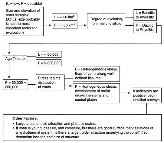
Fig. 7.25
Flow chart for exploration and evaluation of the geothermal potential of composite cones.